
شواطئ السرقة


شواطئ السرقة هي شواطئ تمتد على طول الجانب الشمالي من شبه جزيرة بايرز ، وجزيرة ليفينغستون في جزر شيتلاند الجنوبية ، في القارة القطبية الجنوبية بين نقطة إسيكس غرباً ونقطة نيديليا شرقاً. ويخترقها نهرا إريدانوس وبديك .
استخدم جيمس ويدل اسم "شاطئ السرقة" في الفترة ما بين 1820 و1823. وقد نشأ هذا الاسم من سرقة الإنجليز لجلود الفقمة التي جمعتها السفينة الأمريكية "تشارتي" (بقيادة الكابتن تشارلز إتش. بارنارد) من نيويورك في يناير 1821. وشهدت المنطقة منافسة شرسة بين صيادي الفقمة البريطانيين والأمريكيين خلال أوائل عشرينيات القرن التاسع عشر.
موقع
تقع الشواطئ في مركز 62°36′57.6″S 61°04′58.8″W / 62.616000°S 61.083000°W / -62.616000; -61.083000 (الخرائط البريطانية في عام 1968، والخرائط الإسبانية المفصلة في عام 1992، والخرائط البلغارية في عامي 2005 و2009).
خرائط
- خريطة لجنوب شتلاند، بما في ذلك جزيرة كورونيشن، وغيرها، من رحلة استكشافية قامت بها السفينة الشراعية دوف في عامي 1821 و1822 بقيادة جورج باول، قائد السفينة نفسها. مقياس الرسم 1:200000 تقريبًا. لندن: لوري، 1822.
- شبه جزيرة بايرز، جزيرة ليفينغستون. خريطة طبوغرافية بمقياس 1:25000. مدريد: Servicio Geográfico del Ejército، 1992. (صورة الخريطة في الصفحة 55 من الدراسة المرتبطة)
- إل إل إيفانوف وآخرون. القارة القطبية الجنوبية: جزيرة ليفينغستون وجزيرة غرينتش، جزر شيتلاند الجنوبية . خريطة طبوغرافية بمقياس 1:100000. صوفيا: لجنة أسماء الأماكن في القارة القطبية الجنوبية في بلغاريا، 2005.
- إل إل إيفانوف. القارة القطبية الجنوبية: جزيرة ليفينغستون وجزر غرينتش وروبرت وسنو وسميث. مؤرشفة في 24 أبريل 2008 على موقع Wayback Machine . خريطة طبوغرافية بمقياس 1:120000. ترويان: مؤسسة مانفريد فورنر، 2009. ISBN 978-954-92032-6-4
- Antarctic Digital Database (ADD). Scale 1:250000 topographic map of Antarctica. Scientific Committee on Antarctic Research (SCAR). Since 1993, regularly upgraded and updated.
- L.L. Ivanov. Antarctica: Livingston Island and Smith Island. Scale 1:100000 topographic map. Manfred Wörner Foundation, 2017. ISBN 978-619-90008-3-0

In fiction
Robbery Beaches are part of the mise-en-scène in the Antarctica thriller novelThe Killing Ship authored by Elizabeth Cruwys and Beau Riffenburgh under their joint alias Simon Beaufort in 2016, and are shown on a sketch map of Livingston Island illustrating the book.[1][2]
Gallery
 Eastern Byers Peninsula in Livingston Island with left to right Lair Hill, Robbery Beaches, Sparadok Point, Tsamblak Hill and Negro Hill in the middle ground; and Rowe Point, Cutler Stack, Ivanov Beach, Nedelya Point, Urvich Wall surmounted by the slopes of Rotch Dome, and Clark Nunatak in the background
 Topographic map of Antarctic Specially Protected AreaASPA 126 Byers Peninsula
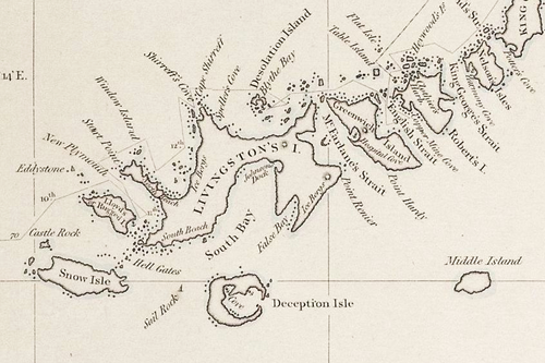 Fragment of George Powell's 1822 chart of the South Shetland Islands and South Orkney Islands featuring Robbery Beaches (as 'North Beach')
 Topographic map of Livingston Island and Smith Island
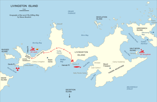 Geography of the novel The Killing Ship by Simon Beaufort
Notes
- ↑S. Beaufort. The Killing Ship. Sutton, Surrey: Severn House Publishers, 2016. 224 pp. ISBN 978-0-7278-8639-2
- ↑The Killing Ship. Susanna Gregory Website, 2019
References
 This article incorporates public domain material from "Robbery Beaches". Geographic Names Information System. United States Geological Survey.
- Beaches of Livingston Island
- Livingston Island geography stubs