
رادار بحري

الرادارات البحرية هي رادارات تعمل بنطاقي X و S ، مثبتة على السفن، وتُستخدم لرصد السفن الأخرى والمخاطر البرية، وتحديد الاتجاه والمسافة لتجنب الاصطدامات والملاحة في البحر. [ 1 ] وهي أجهزة ملاحة إلكترونية تستخدم هوائيًا دوارًا لمسح شعاع ضيق من الموجات الدقيقة حول سطح الماء المحيط بالسفينة حتى الأفق، حيث ترصد الأهداف من خلال الموجات الدقيقة المنعكسة منها، مما يُنتج صورة لمحيط السفينة على شاشة العرض . يتميز رادار النطاق X ورادار النطاق S بخصائص وقدرات رصد مختلفة. [ 1 ] تحمل معظم السفن التجارية رادارًا واحدًا على الأقل من كل نوع لضمان رصد الأهداف والاستجابة لها بشكل مناسب. [ 1 ] على سبيل المثال، يعمل رادار النطاق S بكفاءة أعلى في ظروف البحر المضطربة والمطر مقارنةً برادار النطاق X، ومع ذلك، يتميز رادار النطاق X بدقة ووضوح أكبر في الطقس الصافي. [ 1 ]
يُعدّ الرادار عنصرًا حيويًا للملاحة من أجل السلامة في البحر وبالقرب من الشاطئ. فهو يُتيح الحفاظ على "مراقبة" مستمرة، ويُعتبر أحد الوسائل المعتمدة والمتاحة للامتثال للقاعدة 5، التي تنص على ضرورة الحفاظ على مراقبة مناسبة بموجب اللوائح الدولية لمنع التصادم في البحر . [ 2 ] يجب أن يكون قادة السفن وفرق القيادة على متنها قادرين على مناورة سفنهم بالقرب من المخاطر الملاحية في أسوأ الظروف. [ 3 ] ويشمل ذلك الحاجة إلى الملاحة "العمياء"، عندما تكون الرؤية ضعيفة أو معدومة ليلًا أو بسبب سوء الأحوال الجوية كالضباب. [ 3 ] بالإضافة إلى الرادارات البحرية المثبتة على السفن، في الموانئ، تُستخدم أنظمة رادار خدمة حركة السفن الساحلية من قِبل مسؤولي الموانئ وخفر السواحل لمراقبة وتنظيم حركة السفن في المياه المزدحمة.
تجنب الاصطدام
As required by COLREGS, all ships shall maintain a proper radar lookout if it is available on board to obtain early warning of risk of collision. Radar plotting with the use of an EBL and VRM, or the ARPA should be used to determine the information of movement and the risk collision of other ships in vicinity.[4] Information given to the user includes bearing, distance, CPA (closest point of approach) and TCPA (time of closest point of approach).[4]
Navigation
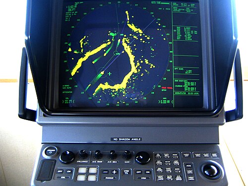
Marine radar systems can provide very useful radar navigation information for navigators on board ships. The ship's position could be fixed by the bearing and distance information of a fixed, reliable target on the radar screen.
Radar controls
Marine radar has performance adjustment controls for brightness and contrast, also manual or automatic adjustment of gain, tuning, sea clutter and rain clutter suppression, and interference reduction. Other common controls consist of range scale, bearing cursor, fix/variable range marker (VRM) or bearing/distance cursor (EBL).
Errors
Marine radars are subject to similar errors of other types of radar.[5] These include radar plotting errors such as range errors, errors in bearing and the incorrect use of own vessel's data.[5]
Use with other equipment
Radars are rarely used alone in a marine setting. A modern trend is the integration of radar with other navigation displays on a single screen, as it becomes quite distracting to look at several different screens. Therefore, displays can often overlay an electronic GPSnavigation chart of ship position, and a sonar display, on the radar display. This provides a combined view of surroundings, to maneuver the ship.
In commercial ships, radars are integrated into a full suite of marine instruments including chartplotters, sonar, two-way marine radio, satellite navigation (GNSS) receivers such as the US Global Positioning System (GPS), and emergency locators (SART). With digital data buses to exchange data, these devices advanced greatly in the early 21st century. For example, some have 3D displays that allow navigators to see above, below and all around the ship, including overlays of satellite imaging.
References
روابط خارجية
- Calculatoredge.com
- Radartutorial.eu
- Earth.esa.int
- تمت أرشفة موقع Alphalpha.org بتاريخ 13 أكتوبر 2011 على موقع Wayback Machine .
- Macuait.com
- الرادار في القرن الحادي والعشرين
- رادارات بحرية
- وسائل الملاحة