
وادي بينغهام، يوتا
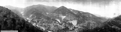
كانت بينغهام كانيون مدينة تقع سابقًا في جنوب غرب مقاطعة سولت ليك بولاية يوتا الأمريكية، في وادٍ ضيق على الجانب الشرقي من جبال أوكير . ازدهرت منطقة بينغهام كانيون خلال السنوات الأولى من القرن العشرين، مع بدء استغلال رواسب النحاس الغنية في الوادي، وبلغ عدد سكانها في ذروتها حوالي 15000 نسمة. إلا أن نجاح المناجم المحلية كان سببًا في زوال المدينة: فبحلول منتصف القرن العشرين، بدأ منجم بينغهام كانيون الضخم ذو الحفرة المكشوفة بالتعدي على أراضي المدينة، مما أجبر السكان على النزوح. وبحلول سبعينيات القرن العشرين، كان المنجم قد التهم معظم أراضي المدينة، وصوّت السكان القلائل المتبقون على إلغاء صفة البلدية والتخلي عن المدينة. لم يبقَ أي أثر لبينغهام كانيون اليوم. [ 2 ]
تاريخ

استمدت منطقة بينغهام كانيون اسمها من أول مستوطنين لها، وهما الأخوان توماس وسانفورد بينغهام، اللذان وصلا إلى الوادي عام 1848. في البداية، استُخدمت المنطقة لرعي الماشية وقطع الأشجار، لكنّ التركيز الاقتصادي للمنطقة تغيّر مع اكتشاف رواسب غنية من خامات الذهب والفضة في الوادي عام 1863. ازدهرت أنشطة التعدين في بينغهام كانيون بعد أن أكملت شركة سكة حديد بينغهام كانيون وكامب فلويد خطها إلى الوادي عام 1873، ومع نمو المنطقة، تحوّل التركيز إلى خامات النحاس عالية الجودة في المنطقة. [ 3 ] ومع نمو المناجم، توسّعت بلدة بينغهام أيضًا، وامتدّت على طول قاع الوادي الضيّق والمنحدر أسفل المناجم.

شهدت مناجم بينغهام كانيون أزهى عصورها خلال السنوات الأولى من القرن العشرين، حيث تم دمج المناجم الصغيرة في المنطقة تحت ملكية شركات كبرى. وكان أهم تطور حدث في عام 1903، عندما أسس دانيال سي. جاكلينغ شركة يوتا كوبر لبدء التعدين السطحي في بينغهام كانيون. ازدهر منجم شركة يوتا كوبر، مما أدى إلى تدفق هائل من السكان الجدد إلى الوادي. وتم تأسيس بلدة بينغهام كانيون رسميًا في 29 فبراير 1904. [ 2 ]


By the 1920s, the city of Bingham Canyon was at its peak, with perhaps 15,000 inhabitants. Urban development spread for some seven miles along the single, narrow road winding up the steep canyon floor.
As with many western mining towns, the Bingham Canyon area evolved into a collection of diverse neighborhoods, many with pronounced ethnic affiliations. Many Scandinavians lived in the Carr Fork area, while southern and eastern Europeans congregated in Highland Boy, which was in another branch canyon toward the top of the main city. As the mainstreet in the bottom of the canyon grew, Copperfield became the name of the upper section of the main town. Bingham itself attracted British, French, Irish, Puerto Rican, Mexican, and other immigrants and ethnicities. Numerous other small neighborhoods and communities also existed. Most took the name of the mine where they were located. Commercial, Boston Con, and "the Niagara" were the first three communities to be mined away or covered, as the last one was by Galena Gulch waste dumps. Others were the Galena, Old Jordan, and Silver Shield (these three found in Galena Gulch), along with Niagara. Telegraph was in the upper part of the canyon, along with Copperfield, which was threatened when the mining excavating was expanded and a long one-way tunnel was built before 1940 to allow traffic to reach the upper communities. Many names were colorful: Terrace Heights, Dinkeyville, Jap Camp, and Greek camp were sections of Copperfield. The Frisco, Yampa, Phoenix, and Apex were in Carr Fork along with Highland Boy. Further down the canyon were Markham, Freeman, and Frog Town (lower Bingham).

The size and importance of the Bingham community began to fade as early as the 1920s. The canyon's difficult geography made urban development difficult, while exposing the town to the hazards of fire and avalanche. The first effort to reduce settlement in the canyon came in 1926, when Utah Copper established the town of Copperton on the flats east of the canyon mouth. This was a lovely community with many copper products used in the building of the houses, and the low rent encouraged company employees to live there. In 1956, Kennecott sold the homes to employees for $4,800 to $6,000. Increasing mechanization at the mine also reduced local employment—and hence, Bingham Canyon's population.
On 17 February 1926, seventy-nine people were killed when a snow avalanche destroyed a mining camp in the area.[5]
By the 1930s it was becoming apparent that the most significant threat to the town of Bingham was the mine itself, whose ever-expanding open pit began encroaching on lands formerly occupied by miners' neighborhoods. The mine continued to eat away at Bingham throughout the middle years of the twentieth century, and by 1971 little of the town remained. That November, Bingham Canyon's 31 remaining residents voted 11–2 to disincorporate the town,[2] and the last buildings at Bingham were razed in 1972. Today, most of the land once occupied by Bingham has been consumed by the Bingham Canyon Mine.
Notable people
- Keith Conners, psychologist, best known for establishing the first standards for the diagnosis of attention deficit hyperactivity disorder (ADHD)[6]
- David Daniel Marriott, former U.S. Representative[7]
- John Saltas, founder of alternative weekly Salt Lake City newspaper Salt Lake City Weekly[8]
See also
References
- 12U.S. Geological Survey Geographic Names Information System: Bingham Canyon
- 123"City of Bingham Canyon". Utah Division of State Archives. Salt Lake City, UT. July 2, 2003. Retrieved May 5, 2017.
- ↑Hilton, George W. American Narrow Gauge Railroads, p. 530, Stanford University Press, Stanford, California, 1990.
- ↑"Niagara Mining and Smelting Co". Bingham Canyon, UT. Retrieved August 29, 2024.
- ↑""Disasters"". Powell Valley News. January 7, 1927. Retrieved August 21, 2023.
- ↑Carey, Benedict (July 13, 2017). "Keith Conners, Psychologist Who Set Standard for Diagnosing A.D.H.D., Dies at 84". Retrieved August 23, 2017– via NYTimes.com.
- ↑Haymond, Jay M. "David Daniel Marriott". Utah.gov. Retrieved February 1, 2020.
- ↑"City of Bingham Canyon". Miner Details: The official site of Bingham High School Alumni & Friends. Retrieved September 2, 2023.
http://www.ghosttowns.com/states/ut/copperfield.html
http://eldonbray.blogspot.com/2012/04/small-towns-in-bingham-canyon.html
http://www.kennecott.com/library/media/2007_Educators_Brochure.pdf
Bibliography
- Carr, Stephen L. The Historical Guide to Utah Ghost Towns. Salt Lake City: Western Epics, 1972. ISBN 978-0-914740-30-8.
- Sillitoe, Linda. A History of Salt Lake County. Salt Lake City: Utah State Historical Society, 1996. ISBN 0-913738-04-2.
Further reading
- (1994) "Bingham Canyon" article in the Utah History Encyclopedia. The article was written by Scott Crump and the Encyclopedia was published by the University of Utah Press. ISBN 9780874804256. Archived from the original on December 3, 2023 and retrieved on April 13, 2024.
- (1994) "Copper Mining" article in the Utah History Encyclopedia. The article was written by Philip F. Notarianni and the Encyclopedia was published by the University of Utah Press. ISBN 9780874804256. Archived from the original on November 3, 2022 and retrieved on April 12, 2024.
External links
 Media related to Bingham Canyon, Utah at Wikimedia Commons
- Ghost towns in Utah
- Populated places in the United States established in 1863
- Populated places disestablished in 1971
- Mining communities in Utah
- Ghost towns in Salt Lake County, Utah
- Company towns in Utah
- Former cities in Utah
- 1863 establishments in Utah Territory
- 1971 disestablishments in Utah