
بلاتوبولجيوم

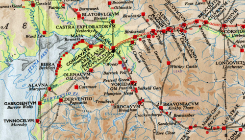


كان بلاتوبولجيوم حصنًا رومانيًا ، يقع في الموقع الحديث المعروف باسم بيرنز، في دومفريشير ، اسكتلندا . وكان يحمي الطريق الغربي الرئيسي المؤدي إلى اسكتلندا.
كانت واحدة من "حصون المواقع الأمامية" خارج الإمبراطورية الرومانية عندما كانت الحدود على جدار هادريان، وتقع على بعد حوالي 11 ميلاً من حصن كاسترا إكسبلوراتوروم (نيذربي، كمبريا).
اسم
ذُكرت بلاتوبولجيوم في دليل أنطونين . يُشتق الاسم من الجذور البريتونية *blāto- بمعنى "زهرة، إزهار" أو *blāto- (من *mlāto- الأقدم ) بمعنى "دقيق"، و *bolgo- بمعنى "كيس، انتفاخ". قد يعني الاسم "تلة مزهرة" أو "منخفض مزهر". مع ذلك، ونظرًا لوجود مخازن حبوب في الحصن، فقد يكون بلاتوبولجيوم لقبًا يعني " أكياس الدقيق ". [ 1 ]
تاريخ
There are several camps near Birrens[2] at least one of which was first occupied in the Flavian period from 79 AD onwards probably during the Agricolan campaigns, when its internal buildings were presumably of timber.[3] Under Hadrian when the frontier was established on Hadrian's Wall soon after 122, a new fort was constructed as an outpost fort on the site of a late 1st century fortlet with central timber buildings and a large western annexe.[4] The visible fort and its internal buildings date from the Antonine period around 142 after the reconquest of the Scottish Lowlands when the earlier fort was rebuilt and enlarged to protect the western road to the Antonine Wall and to accommodate a nominally 1,000-strong milliaria equitata garrison of the 1st Cohort Nerviana Germanorum,[5] a mixed unit of cavalry and infantry of the auxiliary army. It was destroyed perhaps by enemy action around 155 and the replacement stone buildings, although of much poorer quality, in the second Antonine period dating to 159 onwards were for the new garrison of the 2nd Cohort of Tungrians, likewise milliaria equitata. From about 163 it was again an outpost of Hadrian's Wall and was finally abandoned by about 184.
The later fort formed the northern terminus of the Roman-era Watling Street (using an extended definition of this road), or more simply Route 2 of the Antonine Itinerary. It was located in the territory of the Selgovae.
Finds
There have been more inscribed and sculptured stones found at Birrens than anywhere else in Scotland.[6] An altar stone dedicated to the Celtic goddess Ricagambeda was found at Birrens.[7]
References
- ↑Rivet, A. L. F.; Smith, Colin (1981) [1979]. The Place-Names of Roman Britain. London: Book Club Associates. pp. 268–269.
- See also Rivet, A. L. F.; Jackson, Kenneth (1970). "The British Section of the Antonine Itinerary". Britannia. 1: 69. JSTOR 525833.
- يلخص جيمس، آلان ج. (2014) تفسيرات الاسم في كتابه " اللغة البريتونية في الشمال القديم: دليل لأدلة أسماء الأماكن" (ملف PDF) . المجلد 2: دليل العناصر. الصفحات 39، 42. مؤرشف من النسخة الأصلية (ملف PDF) بتاريخ 11 سبتمبر 2014.
- ↑ حصن بيرنز (بلاتوبولجيوم) الروماني https://www.roman-britain.co.uk/places/blatobulgium/
- ↑ بيرنز https://canmore.org.uk/site/67099/birrens
- ↑ بيرنز https://canmore.org.uk/site/67099/birrens
- ^ Cohors Primae Nervana Germanorum milliaria equitata https://www.roman-britain.co.uk/regiments/coh1ger/
- ↑ كيبي، لورانس (1994). "النقوش والمنحوتات الرومانية من بيرينز: مراجعة" (ملف PDF) . معاملات جمعية دومفريشير وغالاوي للتاريخ الطبيعي والآثار . 69 : 35-51 . مؤرشف من الأصل (ملف PDF) في 10 يوليو 2018. تم الاطلاع عليه في 9 يوليو 2018 .
- ↑ هنتر، فريزر؛ كاروثرز، مارتن. "تقرير موجز عن الوجود الروماني" (ملف PDF) . مركز التراث الاسكتلندي . مؤرشف من الأصل (ملف PDF) بتاريخ 22 أبريل 2016. تم الاطلاع عليه بتاريخ 28 أبريل 2018 .
55°03′54″ شمالاً 3°13′28″ غرباً / 55.0651° شمالاً 3.2244° غرباً / 55.0651; -3.2244
- تاريخ مقاطعة دومفريشير
- الحصون الرومانية المساعدة في اسكتلندا
- المعالم الأثرية المسجلة في دومفريز وغالاوي
- بقايا روما القديمة
- سكوتلاند ستابس