Bracondale was the name of a former Toronto suburb that was annexed by the city in 1909;[2] and north of Davenport Road, constituted the northern part of what eventually became the provincial electoral district. It was part of the northwestern expansion of the city that included Wychwood Park, and the City of West Toronto (now known as The Junction).[2] The constituency was first contested during Ontario's 17th general election on 1 December 1926.[3]Arthur Russell Nesbitt, was elected its first Member of the Legislative Assembly (MLA).[4] He was a member of Ontario Conservative Party.[4] The constituency's first Ontario Liberal MLA was Lionel Conacher, a famous Canadian athlete that retired from the National Hockey League to start a career in politics.[5] He was elected on 6 October 1937 in a very close race with the constituency's incumbent MLA, Nesbitt.[6] Nesbitt claimed that two ballot boxes were missing and one was filled with fraudulent ballots.[7] The constituency's returning officer was arrested, and denied bail because he had a quantity of ballots stuffed in his pockets.[7] Soon after Conacher was elected as an MLA, the legislature changed the designation for its members to Member of Provincial Parliament (MPP) in 1938.
Bracondale's most notable event came in 1943. Its residents elected Rae Luckock, one of two Co-operative Commonwealth Federation (CCF) female MPPs to share the title "first-female MPP"; the other was Agnes Macphail in York East.[8] Luckock lost the 4 June 1945 provincial election to Conservative Harry Hyland Hyndman, which saw the Conservatives sweep into a majority government, by gaining most of the extra seats from the CCF.[9]
Boundaries
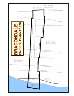
The original boundaries for Bracondale, used for the 1926 and 1929 elections
1926 to 1934 boundaries
Bracondale was a long and narrow constituency, ranging from the Canadian National Exhibition Grounds in the south to the city limits at St. Clair Avenue in the north, in Toronto's west-end. It included parts of the present-day neighbourhoods of Bracondale Hill, Davenport, Dovercourt Park, Dufferin Grove, Little Portugal, and Liberty Village. Its southern boundary was Lake Ontario. Its eastern boundary started on the west side of Strachan Avenue. It went north on Strachan to Queen Street West and jogged westward along Queen's south side to Crawford Avenue. It then went north on Crawford's west side until Dundas Street West, where it went eastward along the northern section of Dundas to Beatrice Street. It went north on Beatrice's west side straight through to Bloor Street West. It then jogged east on Bloor's north side to Christie Avenue. It then went along Christie to the northern boundary, the city limits just north of St. Clair Avenue West. It jogged westward along the city limits to Oakwood Avenue. It then went south along Oakwood's eastside to Davenport Road. It then jogged along Davenport's south-side to Dovercourt Road. It then went south on Dovercourt's east-side to Atlantic Avenue. On Atlantic's east-side to Lake Ontario.[10][11]
1934 to 1967 Boundaries
Bracondale in context with the other Toronto districts in 1926 and 1929
Bracondale was a long and narrow constituency, ranging from the Canadian National Exhibition Grounds in the south to the city limits immediately north of St. Clair Avenue, in Toronto's west-end. It included parts of the present-day neighbourhoods that belong to Bracondale Hill, Davenport, Dovercourt Park, Dufferin Grove, Little Portugal, and Liberty Village. Its southern boundary was Lake Ontario. Its eastern boundary started on the west-side of Strachan Avenue. It went north on Strachan to Queen Street West and jogged westward along Queen's south side to Crawford Avenue. It then went north on Crawford's westside until Bloor Street West. It then jogged east on Bloor's north side to Christie Avenue. It then went along Christie to the northern boundary, the city limits just north of St. Clair Avenue West. It jogged westward along the city limits to Oakwood Avenue. It then went south along Oakwood's eastside to Davenport Road. It then jogged along Davenport's south-side to Dovercourt Road. It then went south on Dovercourt's east-side to Atlantic Avenue. On Atlantic's east-side to Lake Ontario.[10][11]
In 2012, the historic boundaries are approximately part of the south-east portion of the present-day Davenport constituency,[12] a portion of the southern section of St. Paul's constituency,[13] and most of the western portion of the Trinity–Spadina constituency.[14]
↑Federal and provincial electoral district boundaries are the same in Toronto.
12"Bracondale and Wychwood given special terms by the City Council--West Toronto Annexation passed--Legislature asked to help re street railway lines". Toronto Daily Star. Toronto. 15 December 1908. p.7.
12Forsyth, Robert (11 September 1963). "The Province of Ontario general election 1963 the Voters' List ACT III: Bracondale". The Toronto Star. Toronto. Elections Ontario. p.31.
↑"Davenport"(PDF). 2011 Electoral District Maps. Toronto: Elections Ontario. 2011. Archived from the original(PDF) on 13 November 2011. Retrieved 30 August 2011.
↑"St. Paul's"(PDF). 2011 Electoral District Maps. Toronto: Elections Ontario. 2011. Archived from the original(PDF) on 13 November 2011. Retrieved 30 August 2011.
↑"Trinity–Spadina"(PDF). 2011 Electoral District Maps. Toronto: Elections Ontario. 2011. Archived from the original(PDF) on 13 November 2011. Retrieved 30 August 2011.
↑ للاطلاع على قائمة السير الذاتية لكل عضو من أعضاء البرلمان الإقليمي في كوينز بارك ، انظر أدناه:
للاطلاع على معلومات عن آرثر راسل نيسبيت في الجمعية التشريعية، انظر: "آرثر راسل نيسبيت، عضو البرلمان الإقليمي" . التاريخ البرلماني . تورنتو: الجمعية التشريعية لأونتاريو. 2016.
للاطلاع على معلومات حول ليونيل كوناشر في الجمعية التشريعية، انظر: "ليونيل كوناشر، عضو البرلمان الإقليمي" . التاريخ البرلماني . تورنتو: الجمعية التشريعية لأونتاريو. 2016.
للاطلاع على معلومات عن راي لوكوك في الجمعية التشريعية، انظر "راي لوكوك، عضو البرلمان الإقليمي" . التاريخ البرلماني . تورنتو: الجمعية التشريعية لأونتاريو. 2016.
للاطلاع على معلومات حول هاري والترز في الجمعية التشريعية، انظر: "هاري ليندلي والترز، عضو البرلمان الإقليمي" . التاريخ البرلماني . تورنتو: الجمعية التشريعية لأونتاريو. 2016.
للاطلاع على معلومات عن آرثر فروست في الجمعية التشريعية، انظر: "آرثر جورج فروست، عضو البرلمان الإقليمي" . التاريخ البرلماني . تورنتو: الجمعية التشريعية لأونتاريو. 2016.
للاطلاع على معلومات حول جوزيف غولد في الجمعية التشريعية، انظر: "جوزيف م. غولد، عضو البرلمان الإقليمي" . التاريخ البرلماني . تورنتو: الجمعية التشريعية لأونتاريو. 2016.
للاطلاع على معلومات عن جورج بن في الجمعية التشريعية، انظر "جورج بن، عضو البرلمان الإقليمي" . التاريخ البرلماني . تورنتو: الجمعية التشريعية لأونتاريو. 2016.
↑ "اكتساح المحافظين يُعيد 15 مقعدًا للمحافظين في تورنتو". صحيفة تورنتو ديلي ستار (الطبعة الإضافية الأخيرة) . تورنتو. 1 ديسمبر 1926. ص 1. النتائج بعد فرز 98 مركز اقتراع من أصل 99.
↑ "قائمة الناخبين وأعضاء الهيئة التشريعية الجديدة في أونتاريو". صحيفة تورنتو ديلي ستار . تورنتو. 31 أكتوبر 1929. ص 43.
↑ "نتائج الانتخابات بالتفصيل". صحيفة ذا غلوب . تورنتو. 21 يونيو 1934. ص 3.
↑ "أونتاريو تُصوَّت حسب الدوائر الانتخابية". صحيفة تورنتو ديلي ستار . تورنتو. 7 أكتوبر 1937. ص 5.
↑ وكالة الصحافة الكندية (8 يونيو 1948). "كيف صوّت ناخبو أونتاريو في جميع الدوائر الانتخابية التسعين". صحيفة تورنتو ديلي ستار . تورنتو. ص 24.
↑ وكالة الصحافة الكندية (23 نوفمبر 1951). "كيف صوّت ناخبو أونتاريو في جميع الدوائر الانتخابية التسعين". صحيفة تورنتو ديلي ستار . تورنتو. ص 10. النتائج بعد الإبلاغ عن 101 مركز اقتراع من أصل 109.