
Naples, Maine
Naples is a town in Cumberland County, Maine, United States. It is part of the Portland-South Portland-Biddeford metropolitan area. The population was 3,925 at the 2020 census,[4] and it is home to part of Sebago Lake State Park. Naples is a resort area. Naples is included in the Lewiston-Auburn, Maine metropolitan New England City and Town Area
History
The area was settled in 1774. Farming in Naples, Maine was limited by the soil, which consisted of gravelly loam, its surface strewn with glacial erraticboulders. The uplands, however, provided good grazing for livestock, and hay became the principal crop.[5]
Named for Naples, Italy,[6] the town was incorporated on March 4, 1834,[7] from parts of Otisfield, Harrison, Raymond and Bridgton. Between 1845 and 1856, it annexed more land from Sebago, Otisfield and Bridgton. The Songo Lock, completed two years before town incorporation, linked Long Lake and Brandy Pond with Sebago Lake, allowing passage of boats from Harrison, Maine to Portland through the Cumberland and Oxford Canal in Standish. A canning factory and cooperage were established at Naples village. The community also produced carriages, men's and boy's clothing, boots and shoes.[8]
The scenery of the lakes, however, would make tourism the dominant industry. Visitors in the 19th century included Henry Wadsworth Longfellow and Nathaniel Hawthorne. To accommodate his passengers, Charles L. Goodridge of the Sebago Lake, Songo River & Bay of Naples Steamship Company built a hostelry on a knoll at the southern end of Long Lake. On July 26, 1899, the Bay of Naples Inn opened with 80 bedrooms. It was designed by John Calvin Stevens, who reduced by two-fifths a plan originally created for the ill-fated Metallak Hotel in Colebrook, New Hampshire. While under construction, the Metallak was destroyed in April 1893 during a violent windstorm, and its investors abandoned the project. The Bay of Naples Inn, which faced Mount Washington and the east side of the White Mountains, was a popular resort during the early 20th century. Automobile tourists began arriving after designation of the Theodore Roosevelt International Highway in 1919 (identified as United States Route 302 since 1935).[9] The Bay of Naples Inn remained open through the 1951 season, but in 1964 was deemed unprofitable and razed.[10]
 Naples village c.1920
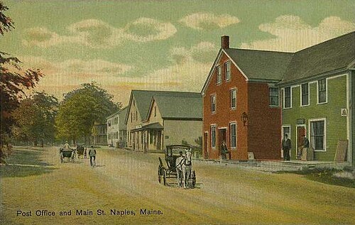 Post Office in c.1910
 The Casino in 1911
 Bay of Naples Inn, 1913
Geography

According to the United States Census Bureau, the town has a total area of 37.25 square miles (96.48 km2), of which 31.82 square miles (82.41 km2) is land and 5.43 square miles (14.06 km2) is water.[2] Naples is drained by the Songo River.
Water bodies that are adjacent to, or within Naples include:
Demographics
| Census | Pop. | Note | %± |
|---|---|---|---|
| 1840 | 758 | — | |
| 1850 | 1,025 | 35.2% | |
| 1860 | 1,219 | 18.9% | |
| 1870 | 1,058 | −13.2% | |
| 1880 | 1,007 | −4.8% | |
| 1890 | 846 | −16.0% | |
| 1900 | 813 | −3.9% | |
| 1910 | 736 | −9.5% | |
| 1920 | 514 | −30.2% | |
| 1930 | 641 | 24.7% | |
| 1940 | 676 | 5.5% | |
| 1950 | 747 | 10.5% | |
| 1960 | 735 | −1.6% | |
| 1970 | 956 | 30.1% | |
| 1980 | 1,833 | 91.7% | |
| 1990 | 2,860 | 56.0% | |
| 2000 | 3,274 | 14.5% | |
| 2010 | 3,872 | 18.3% | |
| 2020 | 3,925 | 1.4% | |
| U.S. Decennial Census[11] | |||

2010 census
بحسب تعداد عام 2010 [ 12 ] ، بلغ عدد سكان البلدة 3872 نسمة، موزعين على 1579 أسرة و1094 عائلة. وبلغت الكثافة السكانية 121.7 نسمة لكل ميل مربع (47.0 نسمة/كم² ) . كما بلغ عدد الوحدات السكنية 3004 وحدة، بمتوسط كثافة 94.4 وحدة لكل ميل مربع (36.4 وحدة/كم² ) . أما التركيبة العرقية للبلدة فكانت كالتالي: 97.4% من البيض ، 0.3% من الأمريكيين من أصل أفريقي ، 0.2% من السكان الأصليين ، 0.5% من الآسيويين ، 0.2% من أعراق أخرى ، و1.4% من أعراق مختلطة. وشكّل المنحدرون من أصول إسبانية أو لاتينية، بغض النظر عن العرق، 0.7% من السكان.
بلغ عدد الأسر 1579 أسرة، منها 30.4% تضم أطفالًا دون سن 18 عامًا، و53.8% عبارة عن أزواج يعيشون معًا، و10.6% ترأسها امرأة بدون زوج، و4.9% يرأسها رجل بدون زوجة، و30.7% لا تُصنف كأسر. وشكّل الأفراد 23.1% من إجمالي الأسر، بينما بلغت نسبة الأسر التي تضم شخصًا واحدًا يعيش بمفرده يبلغ من العمر 65 عامًا أو أكثر 6.6%. وبلغ متوسط حجم الأسرة 2.45 فردًا، ومتوسط حجم العائلة 2.83 فردًا.
كان متوسط العمر في المدينة 42.9 عامًا. 22.2% من السكان كانوا دون سن 18 عامًا؛ و6.8% تتراوح أعمارهم بين 18 و24 عامًا؛ و24.4% تتراوح أعمارهم بين 25 و44 عامًا؛ و33% تتراوح أعمارهم بين 45 و64 عامًا؛ و13.6% تبلغ أعمارهم 65 عامًا فأكثر. أما التوزيع الجنسي للسكان فكان 51.2% ذكورًا و48.8% إناثًا.
تعداد عام 2000
بحسب تعداد عام 2000 [ 13 ] ، بلغ عدد سكان البلدة 3274 نسمة، موزعين على 1297 أسرة و931 عائلة. وبلغت الكثافة السكانية 102.9 نسمة لكل ميل مربع (39.7 نسمة/كم² ) . كما بلغ عدد الوحدات السكنية 2381 وحدة، بكثافة متوسطة قدرها 74.9 وحدة لكل ميل مربع (28.9 وحدة/كم² ) . أما التركيبة العرقية للبلدة فكانت كالتالي: 98.20% من البيض ، 0.15% من الأمريكيين من أصل أفريقي ، 0.31% من السكان الأصليين ، 0.31% من الآسيويين ، 0.21% من أعراق أخرى ، و0.82% من أعراق مختلطة. وشكّل المنحدرون من أصول إسبانية أو لاتينية، بغض النظر عن العرق، 0.21% من السكان.
بلغ عدد الأسر 1297 أسرة، منها 32.1% تضم أطفالًا دون سن 18 عامًا، و58.6% عبارة عن أزواج يعيشون معًا، و8.3% ترأسها امرأة بدون زوج، و28.2% لا تُصنف كأسر. وشكّل الأفراد 21.7% من إجمالي الأسر، بينما بلغت نسبة الأسر التي تضم شخصًا واحدًا يعيش بمفرده يبلغ من العمر 65 عامًا أو أكثر 8.9%. وبلغ متوسط حجم الأسرة 2.52 فردًا، ومتوسط حجم العائلة 2.90 فردًا.

In the town, the population was spread out, with 24.6% under the age of 18, 5.6% from 18 to 24, 29.8% from 25 to 44, 25.3% from 45 to 64, and 14.7% who were 65 years of age or older. The median age was 40 years. For every 100 females, there were 102.3 males. For every 100 females age 18 and over, there were 97.2 males.
The median income for a household in the town was $38,141, and the median income for a family was $40,825. Males had a median income of $31,458 versus $24,596 for females. The per capita income for the town was $18,176. About 6.9% of families and 7.6% of the population were below the poverty line, including 10.4% of those under age 18 and 2.3% of those age 65 or over.
Arts and culture
Site of interest
- Naples Historical Society Museum
Education
The town is home to the Lake Region High School.
Notable people
- Augustus Bove, state legislator
- Richard Cebra, state legislator with the Maine Republican Party
- Major Knight, state legislator with the Greenback Party (1880)
- Daniel Merriam, watercolorist
- Richard Thompson, state legislator (1994-2000)
- Mark Walker, state legislator[14]
References
- ↑"Town of Naples, Maine". Town of Naples, Maine. Retrieved August 26, 2012.
- 12"US Gazetteer files 2010". United States Census Bureau. Retrieved December 16, 2012.
- 12U.S. Geological Survey Geographic Names Information System: Naples, Maine
- ↑"Census - Geography Profile: Naples town, Cumberland County, Maine". United States Census Bureau. Retrieved January 15, 2022.
- ↑Coolidge, Austin J.; John B. Mansfield (1859). A History and Description of New England. Boston, Massachusetts: A.J. Coolidge. pp. 220–222.
coolidge mansfield history description new england 1859.
- ↑"Profile for Naples, Maine, ME". ePodunk. Archived from the original on November 9, 2018. Retrieved August 26, 2012.
- ↑"Naples, Maine". City-Data.com. Retrieved August 26, 2012.
- ↑George J. Varney, "History of Naples, Maine" (1886)
- ↑ تريسي، أ. و. (ديسمبر 1996) [1921]. "عرض الطريق السريع: أمجاد أمريكا". طريق ثيودور روزفلت الدولي، مونتانا (ملف PDF) . وزارة النقل في مونتانا . ص 7. تاريخ الاطلاع: 21 أغسطس 2008 .
- ↑ براينت ف. تولز الابن، فنادق المنتجعات الكبرى في الجبال البيضاء ؛ ديفيد ر. جودين، الناشر؛ بوسطن 1998
- ↑ "تعداد السكان والمساكن" . Census.gov . تم الاطلاع عليه في 4 يونيو 2015 .
- ↑ "موقع مكتب الإحصاء الأمريكي" . مكتب الإحصاء الأمريكي . تم الاطلاع عليه بتاريخ 16 ديسمبر 2012 .
- ↑ "موقع مكتب الإحصاء الأمريكي" . مكتب الإحصاء الأمريكي . تم الاطلاع عليه في 31 يناير 2008 .
- ↑ "ووكر مارك - الجمهوريون في مجلس نواب ولاية مين" . mainehousegop.org . تم الاطلاع عليه بتاريخ 22 فبراير 2024 .
روابط خارجية
- نابولي، مين
- بلدات في مقاطعة كمبرلاند، ولاية مين
- منطقة بورتلاند الحضرية، ولاية مين
- مدن في ولاية مين