
نيوكاميرون
5° شمالاً 16° شرقاً / 5° شمالاً 16° شرقاً / 5؛ 16
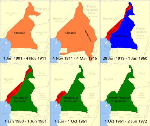
كانت نيوكاميرون اسمًا للأراضي الواقعة في وسط أفريقيا والتي تنازلت عنها الجمهورية الفرنسية الثالثة للإمبراطورية الألمانية في عام 1911. عند توليه منصبه في عام 1907، دعا ثيودور سيتز ، حاكم الكاميرون ، إلى الاستحواذ على أراضٍ من الكونغو الفرنسية . [ 1 ]
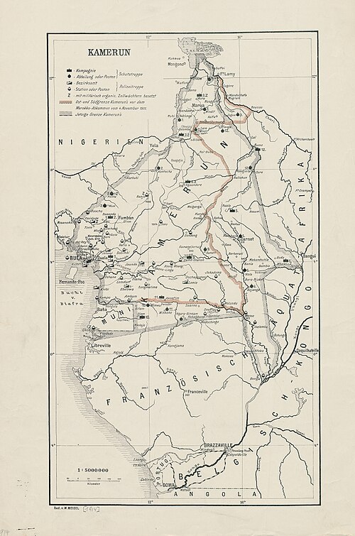
في عام ١٩١١، اندلعت أزمة أغادير بسبب مسألة النفوذ الفرنسي في المغرب . اتفقت فرنسا وألمانيا على التفاوض في ٩ يوليو ١٩١١، وفي ٤ نوفمبر، وقعتا اتفاقية. في مقابل اعتراف ألمانيا بحقوق فرنسا في المغرب [ ٢ ] وشريط أرض في شمال شرق الكاميرون بالقرب من فورت لامي بين نهري لوغون وشاري ، وافقت فرنسا على التنازل عن جزء من الكونغو الفرنسية لألمانيا. كان نهر الكونغو هو المنفذ النهري الرئيسي الوحيد لألمانيا من ممتلكاتها في وسط أفريقيا ، وكان الألمان يأملون أن تتيح لهم المزيد من الأراضي شرق الكاميرون وصولاً أفضل إلى هذا الممر المائي. [ ٣ ]
وبناءً على ذلك، ارتبطت الكاميرون بنهر الكونغو عبر نهر سانغا ، وبمنطقة أوبانغي عند بلدة زينغا ؛ وحُصر شريط صغير من الأراضي الفرنسية بين هذين المنفذين. كما شملت المنطقة شريطًا من شمال الغابون ، مما أدى إلى محاصرة مستعمرة ريو موني الإسبانية. [ 4 ] إجمالًا، نمت مستعمرة الكاميرون من 465,000 كيلومتر مربع إلى 760,000 كيلومتر مربع . [ 2 ] كان أوتو غليم حاكمًا للكاميرون آنذاك. عُرفت المستعمرة الموسعة باسم كاميرون الكبرى. [ 5 ] استغرقت عملية النقل عامين، واكتملت بنقل منطقة أوهام التابعة لأوبانغي-شاري في 1 يونيو 1913. [ 6 ]
The exchange sparked debate in Germany; opponents argued that the new territories presented little opportunity for commercial exploitation or other profit. The German colonial secretary eventually resigned over the matter.[2]
During World War I, France was eager to regain the territories.[7] In 1916, France seized the territories after the fall of German forces in western Africa. After the war, France administered Cameroun as a League of Nations mandate which was distinct from French Equatorial Africa. Neukamerun ceased to exist as the boundary was placed back at its pre-1911 line (except for the strip of land between the Logone and Chari rivers, which remained part of French Equatorial Africa). The territory today forms part of Chad, the Central African Republic, the Republic of the Congo, and Gabon.[8]
Notes
References
- DeLancey, Mark W., and DeLancey, Mark Dike (2000). Historical Dictionary of the Republic of Cameroon (3rd ed.). Lanham, Maryland: The Scarecrow Press. ISBN 0-8108-3775-7.
- Hoffmann, Florian (2007). Okkupation und Militärverwaltung in Kamerun. Etablierung und Institutionalisierung des kolonialen Gewaltmonopols. Göttingen: Cuvillier. ISBN 978-3-86727-472-2
- Marquardsen H., et al. (1914). "Die Grenzgebiete Kameruns Im Süden Und Osten; Hauptsächlich Auf Grund Der Ergebnisse Der Grenzexpeditionen. Mitteilungen Aus Den Deutschen Schutzgebieten. Ergänzungsheft," No. 9a. Ross Archive of African Images, Yale University Art Gallery. Yale University Open Community Collections, JSTOR, https://jstor.org/stable/community.36673070. Accessed 11 Oct. 2024.
- Neba, Aaron (1999). Modern Geography of the Republic of Cameroon, 3rd ed. Bamenda: Neba Publishers. ISBN 0-941815-02-1.
- Ngoh, Victor Julius (1996). History of Cameroon Since 1800. Limbé: Presbook. ISBN 0-333-47121-0.
- Map of KamerunArchived 2007-07-11 at the Wayback Machine
- Bradshaw, Richard., & Fandos-Rius, J. (2016). Historical dictionary of the Central African Republic New edition. ISBN 0810879913.

- الولايات والأقاليم التي تأسست عام 1911
- تم إلغاء تأسيس الولايات والأقاليم في عام 1916
- الكاميرون
- عام 1911 في المغرب
- المستعمرات السابقة في أفريقيا
- 1911 منشأة في أفريقيا
- عمليات حلّ المؤسسات في أفريقيا عام 1916