
تسجيل السياق الواحد
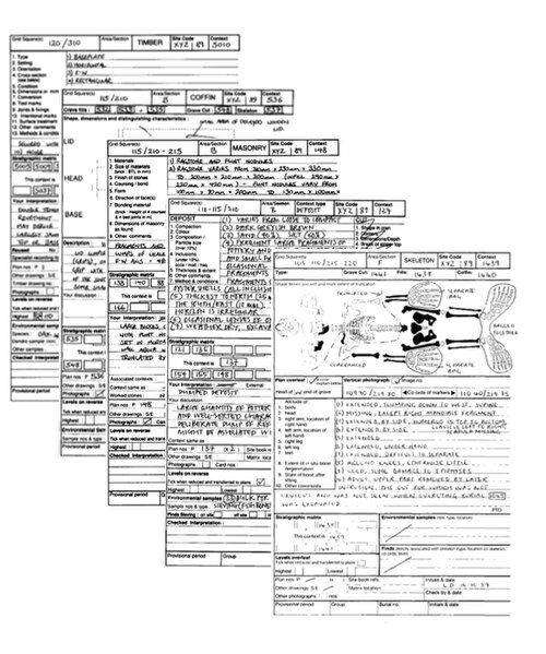
طُوِّر نظام تسجيل السياق الفردي في البداية على يد إد هاريس وباتريك أوتاواي عام ١٩٧٦، بناءً على اقتراح من لورانس كين . ثم طُوِّر لاحقًا من قِبَل قسم الآثار الحضرية (متحف لندن)، ومنه نُقل في منتصف ثمانينيات القرن الماضي على يد بيت كلارك إلى الصندوق الاسكتلندي للآثار الحضرية، ونيك بيرسون إلى صندوق يورك الأثري. وقد أصبح هذا النظام شائعًا في التسجيل والتخطيط، ويُستخدم في العديد من الدول الأوروبية ولبنان، وهو مناسب بشكل خاص لتعقيدات علم الآثار العميق، وخاصةً في المناطق الحضرية. يُمنح كل سياق مُنقَّب عنه "رقم سياق" فريد، ويُسجَّل حسب نوعه على ورقة سياق، وربما يُرسم على مخطط و/أو مقطع . وبحسب ضيق الوقت وأهمية السياقات، قد تُصوَّر أيضًا، ولكن في هذه الحالة، يكون الغرض من التصوير هو تجميع السياقات وارتباطاتها. تُغلَّف المكتشفات من كل سياق وتُعلَّم برقم السياق ورمز الموقع لتسهيل أعمال الربط المرجعية التي تُجرى لاحقًا بعد التنقيب . يُقاس ارتفاع النقاط المهمة في الموقع، مثل أعلى وأسفل الجدار، فوق مستوى سطح البحر، ويُضاف إلى مقاطع المخططات وجداول البيانات. تُسجل الارتفاعات باستخدام جهاز تسوية أو محطة رصد متكاملة، وذلك بالرجوع إلى نقطة مرجعية مؤقتة للموقع . كما تُؤخذ أحيانًا عينات من الرواسب من المواقع، لإجراء تحليلات بيئية لاحقة أو لتحديد العمر العلمي.
عملياً
تُسجَّل السياقات التي يجري التنقيب عنها في جداول خاصة، تختلف في أسلوبها باختلاف الباحثين، ولكنها تشترك عمومًا في خصائص معينة. تحتوي معظم هذه الجداول على أقسام لتكوين التربة أو مقاطع عرضية للقطع. ومن الممارسات الشائعة توفير جداول خاصة لتسجيل السياقات المشار إليها بـ: البناء، والخشب، والهياكل العظمية، مع سرد المتغيرات العديدة التي تهم علماء الآثار في الموقع وبعد التنقيب . كما تُعدّ خطة تتوافق مع مربعات الشبكة (عادةً ما تكون شبكة 5 أمتار).
الكشف عن التسلسل
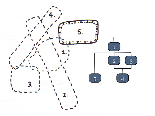
Single context recording of a stratigraphically excavated sequence evolves into an overlay of planned contexts that build a Harris matrix during excavation. (see Stratification (archeology) and Harris matrix) This is demonstrated in the gallery below of a hypothetical and abstract 5 step sequence of contexts. The excavation starts with the planning and removal of a deposit in step 1 and continues down through a sequence of 4 cutfeatures. Note how only the stratigraphic relationships build into the matrix as the excavation progresses rather than all the physical relationships. (For planning convention styles see archaeological plan)
 Step 1
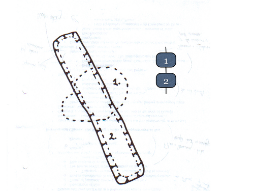 Step 2
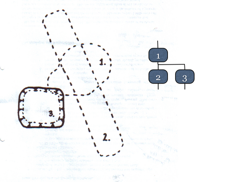 Step 3
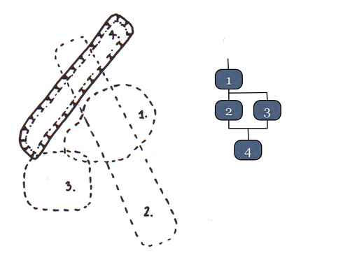 Step 4
 Step 5
In reality the process is more complex and involves many more contexts for the series of features shown in the diagram. This is because the contexts representing the fills have been omitted for simplicity and the matrix shown is more akin to a Carver matrix (Not to be confused with the military term also named CARVER matrix).
Critics
Critics of single context recording point out that it encourages a lazy attitude towards attempts to phase the site while excavation is in progress, and that it diminishes the incentive for archaeologists to interpret what they are digging beyond the boundaries of the context being excavated rather than trying to understand it using the entire area of the site for insight. It is argued that this lack of interpretation leads to a thoughtless use of the law of superposition, creating chronological anomalies from features and contexts of a tunnelling nature such as drain backfills, buried waterfront tiebacks or natural processes. Counter-critics argue that, while this is a possibility, no archaeologist needs to be transfixed by the applied recording system if faced with a stratigraphic conundrum, and that deviation from a pure single context recording regime is not a sin. Furthermore, single context recording is not an excuse for not attempting to view the site as a whole during excavation.
See also
References
- The MoLAS archaeological site manual MoLAS, London 1994. ISBN 0-904818-40-3. Rb 128pp. bl/wh
External links
 Media related to Archaeology at Wikimedia Commons
- Adrian Chadwick - Archaeology at the Edge of Chaos: Further Towards Reflexive Excavation Methodologies
- Methods in archaeology