
Kota Marudu
Kota Marudu (Malay: Pekan Kota Marudu) is the capital of the Kota Marudu District in the Kudat Division of Sabah, Malaysia. Its population was estimated to be around 81,300 in 2019.[1] It is located 130 kilometres north of the state capital, Kota Kinabalu, along the federal highway linking Kota Kinabalu with the town of Kudat, near the northern tip of Borneo.
Places of interest in Kota Marudu include Sorinsim Waterfall, located 40 kilometres from the main town, and Sagabon Park, an agriculture research station on Buyut Lake. Kota Marudu also boasts Southeast Asia's largest solar power station. The town celebrates an annual Maize Festival in honour of the agricultural product's contribution to the district's socio-economic development. The line-up of activities includes a variety of exhibitions, competitions, traditional sports and a beauty pageant.
History
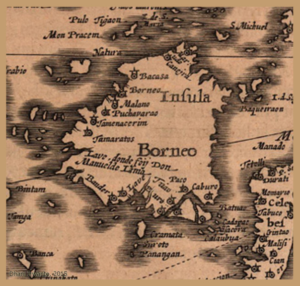
It is not very clear when Kota Marudu was established but it is appeared on the 15th century map of borneo by Johannes Cloppenburgh (circa 1632)[2] and map by Benjamin Wright (1601)[3][4] with name of "Marudo". It is also referred as "Malloodoo" in other old maps.
Etymology
In some other old maps it is also referred to as Bandau. According to the legend, Bandau is a derivative of the word 'Mondou' from the Rungus dialect which means "the head (leader) of all the beasts". Mondou was once believed to have been founded by Aki Rungsud in the area along the Bandau River. The town was renamed 'Kota Marudu' after a fort (kota) built by local warrior named Sharif Usman at Marudu Bay to protect the area from the British North Borneo colonial authorities, where he was considered by the latter as a pirate.[5]
Climate
Kota Marudu has a tropical rainforest climate (Af) with heavy to very heavy rainfall year-round.
| Climate data for Kota Marudu | |||||||||||||
|---|---|---|---|---|---|---|---|---|---|---|---|---|---|
| Month | Jan | Feb | Mar | Apr | May | Jun | Jul | Aug | Sep | Oct | Nov | Dec | Year |
| Mean daily maximum °C (°F) | 29.6(85.3) | 29.8(85.6) | 30.6(87.1) | 31.5(88.7) | 31.9(89.4) | 31.5(88.7) | 31.2 (88.2) | 31.3 (88.3) | 30.8 (87.4) | 30.7 (87.3) | 30.4 (86.7) | 29.9 (85.8) | 30.8 (87.4) |
| متوسط درجة الحرارة اليومية بالدرجة المئوية (الفهرنهايت) | 26.1 (79.0) | 26.3 (79.3) | 26.8 (80.2) | 27.5 (81.5) | 27.9 (82.2) | 27.5 (81.5) | 27.2 (81.0) | 27.2 (81.0) | 26.8 (80.2) | 26.9 (80.4) | 26.8 (80.2) | 26.4 (79.5) | 27.0 (80.5) |
| متوسط الحد الأدنى اليومي °م (°ف) | 22.7 (72.9) | 22.8 (73.0) | 23.1 (73.6) | 23.6 (74.5) | 23.9 (75.0) | 23.5 (74.3) | 23.2 (73.8) | 23.2 (73.8) | 22.9 (73.2) | 23.2 (73.8) | 23.2 (73.8) | 23.0 (73.4) | 23.2 (73.8) |
| متوسط هطول الأمطار بالمليمتر (بوصة) | 409 (16.1) | 233 (9.2) | 152 (6.0) | 111 (4.4) | 174 (6.9) | 143 (5.6) | 128 (5.0) | 107 (4.2) | 154 (6.1) | 196 (7.7) | 228 (9.0) | 318 (12.5) | 2353 (92.7) |
| المصدر: Climate-Data.org [ 6 ] | |||||||||||||
مراجع
- ↑ "السكان حسب المجموعة العرقية، ومنطقة السلطة المحلية، والولاية، ماليزيا" (ملف PDF) . دائرة الإحصاء، ماليزيا. 2010. مؤرشف من الأصل (ملف PDF) بتاريخ 27 فبراير 2012. تم الاطلاع عليه بتاريخ 5 نوفمبر 2017 .
- ↑ "خريطة بورنيو القديمة" .
- ↑ "خريطة بورنيو القديمة من تصميم بنيامين رايت عام 1601" .
- ^ "كارت فان هيت آيلاند بورنيو، 1601، بنيامين رايت" .
- ^ “لاتار بيلاكانج داراه” (في لغة الملايو). مكتب منطقة كوتا مارودو. أرشفة من الأصلي في 7 نوفمبر 2017 . تم الاسترجاع في 7 نوفمبر 2017 .
- ^ "المناخ: كوتا مارودو" . مناخ البيانات.org . تم الاسترجاع في 30 أكتوبر 2020 .


روابط خارجية
 الوسائط المتعلقة بكوتا مارودو في ويكيميديا كومنز
- مقاطعة كوتا مارودو
- مدن في صباح
- مقالات جغرافية قصيرة عن صباح