
Parliamentary Triangle, Canberra
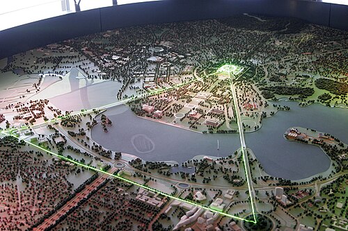
The National Triangle, also known as the Parliamentary Triangle, is the ceremonial precinct of Canberra, containing some of Australia's most important buildings. The Triangle is formed by Commonwealth, Kings and Constitution Avenues. Buildings within the National Triangle have been located and designed intentionally for visual effect, and those of national significance are popular tourist attractions.
The National Triangle was a significant feature of Walter Burley Griffin's Plan for Canberra. The apices of the triangle are Parliament House, the seat of government; the Defence Headquarters at Russell; and City Hill, representing the civilian part of Canberra. Griffin planned the city around two axes which converge in the centre of the National Triangle. The land axis connects Mount Ainslie, Capital Hill and Red Hill and extends off towards Mount Bimberi the Australian Capital Territory's highest mountain. The water axis runs at right angles to the land axis along the length of Lake Burley Griffin.
The southern shore of Lake Burley Griffin bisects the National Triangle forming a smaller Triangle known as the Parliamentary Zone bounded by Kings and Commonwealth Avenues.
Consistent with Walter Burley Griffin's Garden City design, the National Triangle is characterised by streets lined with large deciduous trees, and buildings set in expanses of grassed parkland. Consequently, it has a very open feel and buildings are located several minutes walk away from one another. It was Griffin's original intention for more grand government buildings to be located within the precinct, but these have not eventuated as yet.

Development within the National Triangle is strictly controlled by the National Capital Authority, an agency of the Commonwealth Government (not the ACT Government) within the Department of Infrastructure, Transport, Regional Development, Communications, Sport and the Arts.
Significant buildings and monuments
تتطابق المنطقة التي يغطيها المثلث الوطني إلى حد كبير مع ضاحية باركس . ويُعدّ مبنى البرلمان ومبنى البرلمان القديم أبرز معالم المثلث الوطني. ومن المباني الأخرى المهمة لتصميم المثلث وتناسقه: المحكمة العليا والمعرض الوطني ، الواقعان بالقرب من بحيرة بيرلي غريفين، أمام مبنى البرلمان القديم وإلى الشرق منه، والمكتبة الوطنية ومركز كويستاكون الواقعان أمام مبنى البرلمان القديم وإلى الغرب منه. ويقع ميدان الكومنولث في وسط ضفة البحيرة، بينما يمتد منتزه الكومنولث ومنتزه كينغز على الضفة المقابلة للبحيرة.
تشمل المباني الهامة الأخرى في المنطقة وزارة الخزانة ومبنى جون غورتون . تقع الأجراس الوطنية ، وهي هدية من الحكومة البريطانية بمناسبة مرور 50 عامًا على تأسيس كانبرا، في جزيرة الملكة إليزابيث الثانية . [ 1 ] تقع حديقة الورود الوطنية بجوار مبنى البرلمان القديم، وتقع سفارة الخيام للسكان الأصليين أمامه. يقع ميدان المصالحة ، وهو نصب تذكاري للمصالحة بين السكان الأصليين لأستراليا والمستوطنين، بالقرب من المحكمة العليا. يقع الأرشيف الوطني و"المبنى الغربي" - وهو عبارة عن مكاتب وزارية قديمة - خلف مبنى البرلمان القديم بالقرب من شارع كينغز أفينيو وشارع كومنولث أفينيو على التوالي. تقع وزارات حكومية أخرى، مثل وزارة العدل ووزارة رئيس الوزراء ومجلس الوزراء، في ضاحية بارتون القريبة.
التواصل مع واشنطن العاصمة وبرازيليا

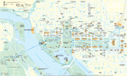
توجد أوجه تشابه بين تصميم كانبرا وتصميم واشنطن العاصمة وبرازيليا . تتكون المدن الثلاث من محاور مثلثة تربط مقرات الحكومة بالمعالم الأثرية الأخرى والأماكن المهمة.
انظر أيضاً
مرجع خارجي
- قانون البرلمان لعام 1974
- سيتي هيل - الخدمات الحضرية
- توسع العاصمة الوطنية - هيئة العاصمة الوطنية
- صحيفة معلومات المنطقة البرلمانية
35°18′ جنوبًا 149°08′ شرقًا / 35.300 درجة جنوبًا 149.133 درجة شرقًا / -35.300; 149.133
مراجع
- ↑ "الكاريلون الوطني" . هيئة العاصمة الوطنية . تم الاطلاع عليه بتاريخ 5 يونيو 2022 .
- الأماكن الحضرية في كانبرا
- معالم بارزة في كانبرا
- المعالم السياحية في كانبرا