
Settegast, Houston
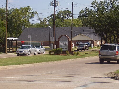
Settegast is a neighborhood in northeast Houston; it has an average population density between one and five.[1] The community is bordered by the 610 Loop, the Union Pacific Railroad Settegast Yard,[2][3] and the old Beaumont Highway. The community has many small, wood-framed houses and empty lots. Habitat for Humanity has a prominent stake in the area,[4] and a community garden is underway. There are few commercial and industrial uses within Settegast.[5] Also, contemporary housing has started to arise within new construction in the area. The City of Houston designated Settegast as a Houston HOPE neighborhood.[6]
History
Settegast was first developed in 1892 by German immigrants William J. and Julius J. Settegast, who had become interested in land speculation back in 1872.[7]
Settegast was further developed as a planned community in the 1940s, and had streets and lots that were platted during the same decade.[8] Settegast was settled by African Americans seeking land on the northeast side of Houston.[5]
The City of Houston annexed Settegast in 1949 and began providing sewer trunk lines in 1965.[9]
In 1966, the Houston-Harris County Economic Opportunity Organization (H-HCEOO) conducted a survey of the Settegast neighborhood termed "The Settegast Report", which was conducted to "gain a better understanding of the problems and issues in one of the city's poorest neighborhoods".[10]
Surveyors found, "though 80% of respondents in Settegast owned their homes, the term 'ownership' must be used in the loosest possible sense...[because] contracts for deed were designed in such a way that borrowers found it impossible to reach the agreed-upon amount because of a multitude of hidden fees and exorbitant finance charges,".[11]
Surveyors found that streamlined sanitation was nonexistent as, "70% of residents received their water from shallow wells that were often contaminated from septic tanks and sewage backups from outhouses". After neighbors found that contaminated well water was being sold to residents, residents, "went to City Hall and demanded a city water supply to replace their contaminated one".[12]
Similarly, surveyors found Settegast was a food desert and that two-thirds of the population did not have a high-school education.[13]
According to Wesley G. Phelps' book A People's War on Poverty: Urban Politics and Grassroots Activists in Houston, an arsonist set fire to the H-HCEOO community center in Settegast on January 17, 1967; moreover, "two thousand completed voter registration forms that had yet to be turned over to the tax assessor-collector" were found.
In 1967, a deputy constable ordered a pregnant resident out of her home due to an eviction order, which the resident claimed the deputy constable, "shoved, cursed, and handcuffed" her and "unfairly booked [her] for aggravated assault".[14] About 2000 Settegast residents met at a local Baptist church and signed a petition "calling for the immediate dismissal of the said deputy constable".[15] The deputy constable was not dismissed, though a protest had happened as a response to the resident's eviction[16]
When Mayor Welch and Congressman Bush "erroneously charged H-HCEOO with using federal funds to stage the protest, the local newspaper repeated the charge and provoked a firestorm of criticism aimed at the organization...[which made] Settegast suff[er] a major setback".[17] "In the wake of the demonstration at City Hall against the treatment of Betty Gentry, members of the Settegast Civic Club, an organization that had existed longer than the poverty program and included several business and religious leaders, expressed fear that protest activity in Settegast was going too far and Earl Allen and his staff were encouraging violence".[18]
Cityscape
Settegast is bounded to the south by the 610 Loop and the Beaumont Freeway, and to the west by a Union Pacific Railroad switching yard.[6]
Rafael Longoria and Susan Rogers of the Rice Design Alliance said that Settegast could be described as "rurban", a word coined in 1918 to describe an area with a mix of urban and rural characteristics.[19] Longoria and Rogers said that the original frame houses, described by the two as "modest," are "sparsely" distributed throughout Settegast. As of 2008, much of the area remained undeveloped, and guinea hens and horses graze on the open fields.[8] Many churches are located in the neighborhood; as of 2008, it had one church per 60 residents.[20]
Economy
Union Pacific operates the Settegast Yard, an intermodal terminal.[21]
Government and infrastructure
Settegast is in Houston City Council District B.[22]
Harris Health System (formerly Harris County Hospital District) operates the Settegast Health Center.[23] The center opened on January 28, 1967.[24] The designated public hospital is Lyndon B. Johnson Hospital in Northeast Houston.[25]
The county commissioner who represents Settegast is Rodney Ellis, Precinct One Commissioner,[26] while Jerry Davis serves as Settegast's council member, District B.[27] Settegast is also a Super Neighborhood and has merged with East Houston, Super Neighborhood #49.[28]
Settegast is under Texas House 142,[29] and is represented by Harold V. Dutton Jr., a native of Fifth Ward.
Sherman Eagleton is the constable for Settegast (Precinct 3).[30]
Education
The area is within the Houston Independent School District. Residents are zoned to Bennie Carl Elmore Elementary School,[31][32]Key Middle School,[33] and Kashmere High School.[34]
Elmore Elementary School has 39 teachers with an average of four years' experience, and the school has all four performance index indicators with one distinction designator, "Top 25% Student Progress".[35]
Key Middle School has 45 teachers with an average of three years' experience, and the school has three out of four performance index indicators with no distinction designators.[36]
تضم مدرسة كشمير الثانوية 39 معلماً بمتوسط خدمة تسع سنوات، وقد حصلت المدرسة على مؤشرين من أصل أربعة مؤشرات أداء دون أي تصنيفات امتياز. [ 37 ]
تاريخ التعليم
قبل الأول من يوليو 2013، [ 38 ] كانت منطقة مدارس نورث فورست المستقلة (التي كانت تُعرف سابقًا باسم منطقة مدارس شمال شرق هيوستن المستقلة) تخدم المجتمع. [ 5 ]
عندما كانت منطقة شمال شرق هيوستن التعليمية منفصلة عنصريًا، كان لمدينة سيتيغاست مدرستها الثانوية الخاصة. [ 5 ] افتُتحت مدرسة سيتيغاست الثانوية، التي تضم الصفوف من الأول إلى الثامن، عام 1951 لخدمة الطلاب السود، وكان عدد طلابها 300 طالب. افتُتحت مدرسة بي سي إلمور الثانوية عام 1957. [ 39 ] بعد افتتاح مدرسة إلمور الثانوية، عملت مدرسة سيتيغاست ومدرسة هيليارد كمدارس ابتدائية مجتمعية. [ 40 ] حُوّلت مدرسة إلمور الثانوية إلى مدرسة إعدادية عند افتتاح مدرسة فورست بروك الثانوية عام 1972. هُدم المبنى واستُبدل بمبنى جديد للمدرسة الإعدادية عام 1999. [ 39 ]
افتُتح مبنى مدرسة إلمور المتوسطة الجديد عام 2000. [ 41 ] وقد بلغت تكلفة هذا المبنى، الذي يضم 40 فصلاً دراسياً وتبلغ مساحته 130 ألف قدم مربع (12 ألف متر مربع ) ، ملايين الدولارات. [ 42 ]
اعتبارًا من عام 2010باعتبارها منطقة تابعة لمنطقة مدارس نورث فورست المستقلة (NFISD)، تم تخصيص منطقة سيتغاست لمدرسة هيليارد الابتدائية، ومدرسة بي سي إلمور المتوسطة، ومدرسة نورث فورست الثانوية . [ 43 ] انضمت مدرسة إلمور إلى منطقة مدارس هيوستن المستقلة (HISD) وتم تحويلها إلى مدرسة ابتدائية خلال عملية دمج منطقة مدارس نورث فورست المستقلة (North Forest ISD) مع منطقة مدارس هيوستن المستقلة (HISD) في 1 يوليو 2013. [ 44 ]
الحدائق والترفيه
تُدير مدينة هيوستن حديقة سيتغاست. [ 45 ] ويخدم فرع جمعية الشبان المسيحية في شمال شرق هيوستن سكان سيتغاست. [ 46 ] وتقع كنيسة ليكوود السابقة في الجزء الشمالي الشرقي من سيتغاست. [ 6 ] وقد تأسست في مخزن أعلاف مُحوّل. وفي 16 يوليو/تموز 2005، انتقلت الكنيسة إلى مبنى هيوستن ساميت السابق . [ 47 ]
انتهاكات بيئية
بحسب تقرير برنامج ECHO التابع لوكالة حماية البيئة الأمريكية لعام 2018، فإن منشأة استعادة غاز مكب النفايات في طريق مكارتي (الواقعة في 9416 لي، هيوستن، تكساس 77078) مصنفة ضمن فئة "المخالفات ذات الأولوية العالية"، حيث تبلغ غراماتها 27,282 دولارًا. [ 48 ]
وبالمثل، وجد برنامج ECHO التابع لوكالة حماية البيئة أن مصنع Queen Ready Mix (الواقع في 8702 Liberty Rd، هيوستن، تكساس 77028) لديه حالة امتثال "عدم امتثال كبير". [ 49 ]
كما وجد برنامج ECHO التابع لوكالة حماية البيئة الأمريكية أن محطة ماجلان إيست هيوستن (الواقعة في 7901 طريق واليسفيل، هيوستن، تكساس 77029) مصنفة ضمن فئة "عدم الامتثال الكبير". [ 50 ] وقد شهدت ماجلان نموًا إيجابيًا في انبعاثات المركبات العضوية المتطايرة، مقاسة بالرطل سنويًا (2008: 65,829؛ 2011: 138,238.40؛ 2014: 167,801.20). [ 51 ]
انظر أيضاً
مراجع
- ↑ "COH, PDD: Council District B: Person/Acre" (PDF) . مارس 2017.
- ↑ "هيوستن (سيتغاست) - شارع كيركباتريك، هيوستن، تكساس" . www.up.com . تم الاطلاع عليه بتاريخ 18 يوليو 2018 .
- ↑ "الخراب والخلاص: البيئة العمرانية في هيوستن" (ملف PDF) . ويلكم ويلسون، فريق هيوستن التاريخي التعاوني . 15 : 14. خريف 2017.
- ↑ "مدينة هيوستن > CitizensNet" . www.houstontx.gov . تم الاطلاع عليه بتاريخ 18-07-2018 .
- 1 2 3 4 " SN#50 ." مدينة هيوستن. تم الاطلاع عليه بتاريخ 20 فبراير 2010.
- 1 2 3 " Settegast ". ( أرشيف ) هيوستن هوب. تم الاطلاع عليه في 20 فبراير 2010.
- ↑ "هيوستن هوب سيتغاست" . مدينة هيوستن . تم الاطلاع عليه بتاريخ 29-05-2013 .
{{cite web}}: CS1 maint: deprecated archiveal service ( link ) () - 1 2 لونغوريا، رافائيل وسوزان روجرز. " حدوة الحصان الريفية الحضرية ". ( أرشيف ) مرجع 73. تحالف رايس للتصميم، (نصف الكرة الشمالي) شتاء 2008. صفحة 20. تم الاطلاع عليه في 24 فبراير 2010.
- ↑ فيشر، روبرت. " السياسة الحضرية في هيوستن، تكساس ". دراسات حضرية ، 1989. 150. تم الاطلاع عليه في 24 فبراير 2010.
- ↑ فيلبس، ويسلي (مايو 2010). "حرب شعبية على الفقر: العمل المجتمعي والسياسة الحضرية في هيوستن، 1964-1976" (ملف PDF) . بروكويست، جامعة رايس : 325.
- ↑ فيلبس، ويسلي (مايو 2010). "حرب شعبية على الفقر: العمل المجتمعي والسياسة الحضرية في هيوستن، 1964-1976" (ملف PDF) . بروكويست، جامعة رايس : 127.
- ↑ فيلبس، ويسلي (مايو 2010). "حرب شعبية على الفقر: العمل المجتمعي والسياسة الحضرية في هيوستن، 1964-1976" (ملف PDF) . بروكويست، جامعة رايس : 132.
- ↑ فيلبس، ويسلي (مايو 2010). "حرب شعبية على الفقر: العمل المجتمعي والسياسة الحضرية في هيوستن، 1964-1976" (ملف PDF) . بروكويست، جامعة رايس : 128.
- ↑ فيلبس، ويسلي. حرب الشعب على الفقر: السياسة الحضرية والناشطون الشعبيون في هيوستن ، ص 152.
- ↑ فيلبس، ويسلي. حرب الشعب على الفقر: السياسة الحضرية والناشطون الشعبيون في هيوستن ، ص 153.
- ↑ فيلبس، ويسلي. حرب الشعب على الفقر: السياسة الحضرية والناشطون الشعبيون في هيوستن ، ص 154.
- ↑ فيلبس، ويسلي. حرب الشعب على الفقر: السياسة الحضرية والناشطون الشعبيون في هيوستن ، ص 154-5.
- ↑ فيلبس، ويسلي. حرب الشعب على الفقر: السياسة الحضرية والناشطون الشعبيون في هيوستن ، ص 156.
- ↑ لونغوريا، رافائيل وسوزان روجرز. " حدوة الحصان الريفية الحضرية " مؤرشفة في 7 فبراير 2016 على موقع Wayback Machine . المرجع 73. تحالف رايس للتصميم، (نصف الكرة الشمالي) شتاء 2008. الصفحات 18-19. تم الاطلاع عليه في 24 فبراير 2010.
- ↑ لونغوريا، رافائيل وسوزان روجرز. " حدوة الحصان الريفية الحضرية " مؤرشفة في 7 فبراير 2016 على موقع Wayback Machine . المرجع 73. تحالف رايس للتصميم، (نصف الكرة الشمالي) شتاء 2008. الصفحات 21. تم الاطلاع عليه في 24 فبراير 2010.
- ↑ " هيوستن، تكساس (سيتغاست) ". ( أرشيف ) يونيون باسيفيك . تم الاطلاع عليه في 20 فبراير 2010.
- ↑ مدينة هيوستن، خرائط دوائر المجلس، الدائرة ب . مدينة هيوستن. تم الاطلاع عليه بتاريخ 5 نوفمبر 2011.
- ↑ " مركز سيتغاست الصحي، مؤرشف بتاريخ 21-09-2008 في أرشيف الإنترنت ." مقاطعة مستشفى هاريس . تم الاطلاع عليه بتاريخ 20 فبراير 2010.
- ↑ " تاريخٌ عريقٌ من الرعاية لأكثر من 45 عامًا " (رابطٌ قديمٌ مؤرشفٌ بتاريخ 6 ديسمبر 2012 على archive.today ). مستشفى مقاطعة هاريس . تم الاطلاع عليه بتاريخ 9 فبراير 2012.
- ↑ "دليل العيادات/مراكز الطوارئ/مراكز التسجيل حسب الرمز البريدي" . منطقة مستشفيات مقاطعة هاريس . ١٩ نوفمبر ٢٠٠١. مؤرشف من الأصل في ١٩ نوفمبر ٢٠٠١. تم الاطلاع عليه بتاريخ ٨ أبريل ٢٠٢١ .- انظر الرمز البريدي 77028. انظر هذه الخريطة للرموز البريدية ذات الصلة .
- ↑ "مقاطعة هاريس، الدائرة الأولى - نبذة عن الدائرة الأولى" . hcp1.net . تم الاطلاع عليه بتاريخ 18-07-2018 .
- ↑ "مجلس مدينة المنطقة ب" . www.houstontx.gov . تم الاطلاع عليه بتاريخ 18-07-2018 .
- ↑ "أفضل حي رقم 50 - سيتغاست" . www.houstontx.gov . تم الاطلاع عليه بتاريخ 18-07-2018 .
- ↑ "الدائرة الانتخابية رقم 142" (ملف PDF) .
- ↑ "خريطة مراكز شرطة مقاطعة هاريس" . www.harriscountytx.gov . تاريخ الاسترجاع: 19 يوليو 2018 .
- ↑ " جدول أعمال اجتماع مجلس التعليم بتاريخ 18 يوليو 2013 ". منطقة مدارس هيوستن المستقلة . حدود الحضور الحالية، الملحق هـ-1، يونيو 2013 (20 من 77). تم الاطلاع عليه بتاريخ 10 يوليو 2013. مؤرشف من الأصل بتاريخ 10 يونيو 2013.
- ↑ " جدول أعمال اجتماع مجلس التعليم بتاريخ 18 يوليو 2013 ". منطقة مدارس هيوستن المستقلة . مناطق الحضور المقترحة لمرحلة الانتقال في نورث فورست، الملحق هـ-1 (21 من 77). تم الاطلاع عليه بتاريخ 10 يوليو 2013. مؤرشف من الأصل بتاريخ 10 يونيو 2013.
- ↑ " جدول أعمال اجتماع مجلس التعليم بتاريخ 18 يوليو 2013 ". منطقة مدارس هيوستن المستقلة . حدود الالتحاق المقترحة، الملحق هـ-2، يونيو 2013 (26 من 77). تم الاطلاع عليه بتاريخ 10 يوليو 2013. مؤرشف من الأصل بتاريخ 10 يونيو 2013.
- ↑ " جدول أعمال اجتماع مجلس التعليم بتاريخ 18 يوليو 2013 ". منطقة مدارس هيوستن المستقلة . حدود الالتحاق المقترحة، الملحق هـ-3، يونيو 2013 (31 من 77). تم الاطلاع عليه بتاريخ 10 يوليو 2013. مؤرشف من الأصل بتاريخ 10 يونيو 2013.
- ↑ "مدرسة إلمور الابتدائية" . www.har.com . تم الاطلاع عليه بتاريخ 18-07-2018 .
- ↑ "مدرسة كي المتوسطة" . www.har.com . تم الاطلاع عليه بتاريخ 18-07-2018 .
- ↑ "مدرسة كشمير الثانوية" . www.har.com . تم الاطلاع عليه بتاريخ 18-07-2018 .
- ↑Barajas, Erik. "North Forest ISD officially closes today." KTRK-TV. July 1, 2013. Retrieved on July 1, 2013.
- 12"The History of B.C. ElmoreArchived 2012-09-21 at the Wayback Machine." B.C. Elmore Middle School. Retrieved on December 13, 2016.
- ↑Volumes 1-2 of "Public hearing at San Antonio, Texas, September 12, 1966 [and at 3 other cities in Texas, through Oct. 13-14, 1966]." Texas Finance Commission Consumer Credit Study Committee. p. 25. (See Google Search page text) - "The children of Settegast attend schools in their immediate vicinity. B. C. Elmore is the Senior High School, while the lower grades attend Hilliard School and Settegast School."
- ↑"Chapter 5 FACILITIES USE AND MANAGEMENT NORTH FOREST INDEPENDENT SCHOOL DISTRICT." (Archive) Texas Comptroller of Public Accounts. Retrieved on November 21, 2011.
- ↑"The History of B.C. Elmore." (Archive) B.C. Elmore Middle School. Retrieved on November 14, 2011.
- ↑"Settegast." (Archive) Houston HOPE. Retrieved on February 25, 2010. "North Forest ISD Hilliard Elementary offers an Accelerated Reading program, and the 21st Century Mayor’s After School Program. B.C Elmore Middle School has a summer enrichment program for students who want to get a head start on the next school year. North Forest High School offers after-school tutorials for students."
- ↑"Principals selected, changes proposed for North Forest schools." (Archive) Houston Independent School District. Retrieved on June 14, 2013.
- ↑"Our Parks O-Z." City of Houston. Retrieved on February 25, 2010.
- ↑McTaggart, Brian. "Fernandez fails to bolster status with Astros." Houston Chronicle. April 3, 2004. Retrieved on July 17, 2013. "The Northeast Family YMCA was built in 1960 and services 370 households from the neighborhoods of the Fifth Ward, Scenic Woods, Fontaine, Settegast, Lakewood, Wood Glen, Shady Timbers and Riverwood."
- ↑Hlavaty, Craig. "8 years ago today: Lakewood Church moves into Compaq Center." Houston Chronicle. July 16, 2013. Retrieved on July 17, 2013.
- ↑ "تقرير مفصل عن المنشأة | ECHO | وكالة حماية البيئة الأمريكية" . echo.epa.gov . تم الاطلاع عليه بتاريخ 18-07-2018 .
- ↑ "تقرير مفصل عن المنشأة | ECHO | وكالة حماية البيئة الأمريكية" . تم الاطلاع عليه بتاريخ 18-07-2018 .
- ↑ "تقرير مفصل عن المنشأة | ECHO | وكالة حماية البيئة الأمريكية" . تم الاطلاع عليه بتاريخ 18-07-2018 .
- ↑ "تقرير ملوثات الهواء | إيكو | وكالة حماية البيئة الأمريكية" . تم الاطلاع عليه بتاريخ 19-07-2018 .
روابط خارجية
- سيتيغاست - هيوستن هوب
- مدرسة إلمور الابتدائية في مقاطعة كولومبيا البريطانية
- مدرسة إلمور المتوسطة في مقاطعة بي سي (موقع نورث فورست الإلكتروني)
29°50′30″ شمالاً 95°17′35″ غرباً / 29.8416° شمالاً 95.2931° غرباً / 29.8416; -95.2931
- أحياء في هيوستن