
منتزه تومبستون الإقليمي
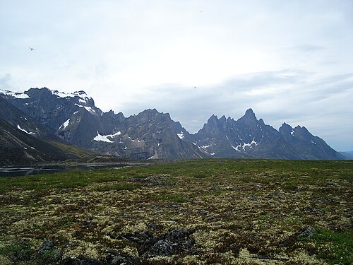


منتزه تومبستون الإقليمي هو منتزه إقليمي في يوكون ، أحد الأقاليم الثلاثة في كندا . يقع في وسط يوكون، بالقرب من الطرف الجنوبي لطريق دمبستر السريع ، ويمتد من علامة الكيلومتر 50.5 إلى علامة الكيلومتر 115.0. يحمي المنتزه أكثر من 2100 كيلومتر مربع من القمم الوعرة، والتضاريس المتجمدة، والحياة البرية، بما في ذلك أجزاء من مرتفعات بلاكستون وجبال أوجيلفي . [ 1 ] سُمي المنتزه بهذا الاسم نسبةً إلى تشابه جبل تومبستون مع شاهد قبر.
تتميز المنطقة بتكوين جيولوجي فريد وتنوع بيئي غني. يقسمها خط تقسيم المياه الذي يفصل المياه المتدفقة إلى نهر يوكون، ومن ثم إلى بحر بيرينغ، عن تلك المتدفقة إلى نهر ماكنزي، ومن ثم إلى بحر بوفورت . يُعد خط تقسيم المياه جزءًا من حزام ناري من الصخور الجرانيتية والسيانيتية ، يُعرف باسم مجموعة تومبستون الطباشيرية ، ويمتد من فيربانكس، ألاسكا ، إلى نهر روس . [ 2 ] توغلت عدة عصور جليدية في المنطقة من الشرق، ففصلتها عن المناطق الواقعة شمالًا وغربًا، والمعروفة باسم بيرينجيا ، والتي لم تتعرض للتجلد، مما أدى إلى تكوين جيب من التضاريس الوعرة. شمال خط تقسيم المياه، تفسح هوامش العصور الجليدية السابقة المجال لتكوينات أرضية من التربة الصقيعية الدائمة أكثر انحدارًا، والتي نجت من التجلد، مع تكوينات هوامش جليدية مثل البينغو ، والمورينات ، والأوتاد الجليدية، والمضلعات، وتلال الصقيع.
تحمي الحديقة تنوعًا بيولوجيًا غنيًا من النباتات والحيوانات، بما في ذلك خمسة أنواع من الطرائد الكبيرة: خروف دال ، ونوعان من الرنة ، والأيائل ، والدببة السوداء ، والدببة الرمادية ، والعديد من الثدييات الصغيرة. كما تُعدّ الحديقة جنةً لهواة مراقبة الطيور، حيث تمّ رصد حوالي 150 نوعًا من الطيور فيها.
Conservation efforts began in 1972 when scientists identified two sensitive sites.[2] Two years later Canada's Department of Indian and Northern Affairs identified an area to be protected from development, in light of the building of the Dempster Highway, to protect the views of Tombstone Mountain.[2] By 2000 the Park was created, a legacy of the land settlement agreement with the Trʼondëk Hwëchʼin First Nation, with a mandate to preserve and enhance its "physical, biological, archaeological and cultural values." The park is jointly administered by the territorial government and the Tr’ondëk Hwëch’in First Nation.
Notable features are Mount Monolith, Tombstone Mountain, and Glissade Pass. The scenic attractiveness of the Park, in particular, has attracted growing numbers of visitors from all parts of the world, with tourism operators now offering excursions through, and into, the Park. Numerous hiking trails intrude into the park from the Dempster corridor (a 1-km strip alongside the highway exempt from the park). Along this strip is an interpretive centre, open in summer, which provides visitors with necessary resources for accessing the backcountry and interpretive programs for understanding it, as well as several car camping sites. There are three designated backcountry campgrounds: Grizzly, Divide, and Talus Lakes.
The park's most imposing feature, Mt. Tombstone, was first climbed by Martyn Williams, Jurg Hofer, and Liz Hofer on June 21, 1973.[3]
References
- ↑"Tombstone Territorial Park - Klondike parks and places - Yukon Territory things to do". www.ehcanadatravel.com. Retrieved 2017-04-03.
- 123"Tombstone Map"(PDF).
- ↑Williams, Martyn; Yukon Conservation Society (1984-01-01). The Yukon wilderness travellers guide. Whitehorse: Yukon Conservation Society. OCLC 16059489.
External links
 Tombstone Territorial Park travel guide from Wikivoyage
- Tombstone Territorial Park at Yukon.ca
- Tombstone Backcountry Camping and Hiking
- Dempster Travelogue
- West Adventures Itinerary
- Parks in Yukon
- Protected areas established in 2000
- 2000 establishments in Canada