
جبل راسك
جبل راسك هو قمة تقع في بلدتي جويت وليكسينغتون في مقاطعة غرين ، نيويورك ، الولايات المتحدة الأمريكية. يبلغ ارتفاعه 1120 مترًا (3680 قدمًا) ، وهو يحتل المرتبة العشرين بين أعلى قمم جبال كاتسكيل ، ويُعتبر عضوًا في مجموعة قمم كاتسكيل العالية . لا يوجد مسار مُمهد، ولكن الوصول إلى القمة عبر الأدغال يُعتبر سهلًا نسبيًا، وهو شرط أساسي لعضوية نادي كاتسكيل ماونتن 3500 .
الجغرافيا
يُعدّ جبل راسك أعلى قمة (والقمة العالية الوحيدة) فيما يُطلق عليه مؤرخ غابات كاتسكيل، مايكل كوديش، اسم سلسلة جبال ليكسينغتون ، وهي السلسلة الشمالية من سلسلتين تتفرعان من جبل هنتر القريب ، ثاني أعلى قمة في كاتسكيل. بين راسك وتايلور هولو، الممر الجبلي الفاصل بينها وبين هنتر شرقًا، تقع قمة غير مُسماة يبلغ ارتفاعها 1110 أمتار (3640 قدمًا) تُعرف باسم إيست راسك . تمتد السلسلة الجبلية غربًا إلى جبلي إيفرغرين وباكسادل قبل أن تنتهي عند ليكسينغتون .
يقع الجبل ضمن مستجمع مياه نهر شوهاري . تُصرف مياه منحدراته الجنوبية بواسطة جدول صغير غير مُسمى يتدفق عبر وادي أوكس إلى جدول هانتر فوق نقطة التقائه بنهر ويست كيل ، الذي يصب بدوره في نهر شوهاري. أما منحدراته الشمالية فتصب مياهها مباشرة في منابع نهر شوهاري أسفلها مباشرة. وتُساهم مياه الجريان السطحي في تغذية خزان شوهاري ، وهو جزء من نظام إمداد المياه لمدينة نيويورك .
رغم أن جبل راسك يبدو صغيرًا مقارنةً بجبل ويست كيل الذي يبلغ ارتفاعه 1180 مترًا (3880 قدمًا) من منظور وادي سبروستون ، إلا أنه أكثر إثارة للإعجاب نظرًا لارتفاعه الشاهق عن قاع الوادي. ويمكن رؤية واجهته الشمالية بالكامل من الطريق السريع NY 296 شمال تقاطعه مع الطريق السريع NY 23A .
يرتفع هذا المنحدر بثبات وانحدار حاد نحو قمة الجبل. ويُحدّ الجنوب منه وادي أوكس هولو، والنتوء الجبلي الواقع جنوبه هو المسار الأكثر استخدامًا لتسلق الجبل. ويؤدي نتوء القمة إلى نتوء صخري جنوبي عند رأس النتوء.
تُعدّ ولاية نيويورك مالكةً لجزء كبير من الجبل، وهو جزء من محمية غاباتها ، ويُصنّف حاليًا ضمن وحدة غابة جبل هنتر البرية التابعة لمنتزه كاتسكيل . إلا أن هناك اقتراحًا لتعديل تصنيف الأراضي الواقعة على جبل راسك ومعظم القمم المجاورة له، وتحويلها إلى وحدة جديدة تُسمى منطقة هنتر-ويست كيل البرية ، مع الحفاظ على ممر يمتد صعودًا على جبل هنتر تحت مسمى غابة جبل راسك البرية (مع العلم أن جبل راسك لن يكون جزءًا منها). وتقع الملكية الخاصة الكبيرة الوحيدة على سفوح الجبل في الجهة الجنوبية الغربية.
تاريخ
أطلق أرنولد هنري غيوت اسم راسك على المنطقة نسبةً إلى صموئيل راسك، الذي ساعد أستاذ الجيولوجيا في جامعة برينستون في أول مسح دقيق لجبال كاتسكيل في سبعينيات وثمانينيات القرن التاسع عشر. ومع ذلك، تشير بعض الأدلة إلى أن غيوت كان ينوي تسمية ما يُعرف اليوم باسم إيست راسك نسبةً إلى راسك، مع الإبقاء على اسم إيفرغرين لراسك الحالية، لكنه أخطأ في خرائطه.
ربما قام غيوت بأول صعود مسجل للجبل خلال مسحه، لكن من غير المعروف ما إذا كان أي شخص آخر قد وصل أولاً.
التاريخ الطبيعي
بحسب كوديش، تفتخر راسك، في أعالي وادي أوكس هولو، بوجود واحدة من الغابات البكر القليلة المتبقية من أشجار الشوكران الشرقي التي رصدها حتى الآن في جبال كاتسكيل. يشير هذا إلى أن قاطعي لحاء الأشجار في أواخر القرن التاسع عشر، الذين أزالوا مساحات شاسعة من المنطقة بحثًا عن التانين ، لم يصلوا إلى هذه المنطقة قط. مع ذلك، فقد استُكشفت القمة جيدًا من قِبل صناعة الأخشاب المحلية، إذ لا تزال طرق جرّ الأخشاب وطرق نقلها موجودة في الغابات اليوم، بعضها على ارتفاع يزيد عن 910 أمتار . أما الغابة الواقعة أسفل هذا الارتفاع، فتُهيمن عليها أشجار الزان والقيقب التي تُعدّ من الأشجار الثانوية الشائعة في جبال كاتسكيل.
فوق تلك الارتفاعات، تستمر تلك الأشجار في النمو، وإن كانت أصغر حجماً وأكثر تقزماً مع ازدياد الارتفاع، حتى تتشارك في النهاية قمة الجبل مع أشجار التنوب الأحمر والتنوب البلسمي التي تنمو في غابات كاتسكيل الشمالية. ومع ذلك، فإن جبل روسك أكثر انفتاحاً وسهولة في العبور من بعض الجبال المجاورة.
الأساليب
لطالما فضّلت ملكية الأراضي والطرق القائمة في المنطقة المسار الجنوبي الشائع صعودًا على طول التلال المؤدية إلى القمة من أوكس هولو، على الرغم من وجود مسارات أسهل نظريًا. إجمالًا، توجد أربعة مسارات للصعود إلى الجبل.
أوكس هولو
Hikers taking this route park at the Spruceton trailhead along Spruceton Road (Greene County Route 7) six miles (9.7 km) east of NY 42 at West Kill. They follow the Spruceton Trail, the old road to the fire tower on Hunter, for roughly 0.5 miles (800 m) until it makes a sharp curve shortly after crossing Hunter Brook.
At that point, an old wood road can be seen intersecting from the southwest. This is followed, making for easy crossings of Hunter's unnamed tributary and the intermittent Ox Hollow drainage brook. A short distance afterward it is at the center of the ridge.
From this point, it is very easy to follow the wide ridge's line straight up to the promontory. A stone wall left over from past attempts to farm this land runs nearly parallel to the route at first, and then it is necessary to either cut across a corner of private property or drop slightly down into the Ox Hollow side to remain on public land. Most hikers choose the former.
The woods here remain fairly open, although stinging nettles flourish here in wetter summers. Above approximately 3,200 feet (980 m), after the last wood road has been crossed and the land belongs to the state once again, the climb becomes more difficult. Not only does the slope becomes steeper and rockier, immature seedlings become denser in the forest understory, making it necessary to gently shove them away and duck underneath or step around them.
Hikers who reach the 3,500-foot (1,100 m) cutoff elevation for High Peak status will find themselves at the base of the shalecliffs around the promontory. This is the crux of the Ox Hollow route. While they are not very sheer and present a number of safe routes to a climber willing to use his or her hands, it can take some time to find one and reach the top. A comparatively easy traverse through the cliffs exists, but is not immediately evident, especially in warmer weather when vegetation limits the view.
Once atop the promontory, the ground is level. Climbers who turn due north at this point, towards the obvious higher ground, invariably find the herd path that leads toward the 3500 Club summit canister. At the point where it climbs up onto the summit cap, there is in all seasons of year an excellent view east and southeast toward Kaaterskill High Peak, Hunter and Southwest Hunter. Next to the top of the short scramble, there is a somewhat limited view across the valley to West Kill's summit nunatak.
Total vertical gain via this route is 1,597 feet (487 m). Approximate distance to the summit from Spruceton Road is 2 miles (3.2 km)
Drainage variant
A small number of hikers prefer to follow the creek at the bottom of Ox Hollow instead of the ridge and climb the hollow's steep headwall to the summit or the connecting ridge to East Rusk. This requires more effort later on but avoids the cliffs.
East from Taylor Hollow
When Hunter and Rusk are climbed on the same outing it is common to follow the ridgeline from the Spruceton Trail at Taylor Hollow between the two peaks. This is a gentler rise that also allows for a visit to East Rusk.
Southwest
Since open land, and driveable roads that run off Rusk Mountain Road, climb a good distance up the mountain in this direction it could, if used, provide a relatively easy hike until just before the promontory. However, this land is privately owned and it would be necessary to get permission to cross it.
North face
While this slope is on public land, it is also necessary to get permission to cross private property to reach its base. Some hikers have taken this approach, mainly for variety's sake. Total gain via this route would be 2,180 feet (660 m). There is no herd path in this direction. Some hikers report views to the Blackhead Range exist but are not significantly different or better than the many found in more accessible locations.
Summit
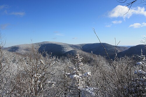
As with many other Catskill peaks, it is difficult to determine where the true high ground on Rusk is as the top is fairly flat. The herd path from the promontory is fairly strong (though some sections near its start can be almost imperceptible in summer when the surrounding ferns grow waist-high) and gets wider and easier to follow as it gets closer to the canister, located near the northwest corner of the summit. There is ample room for a party of hikers to relax and have lunch around it, as many do.
هناك مناظر قليلة تضاهي نقطة المراقبة في بداية مسار القطيع، على الرغم من أن بعض المناظر المحدودة لغرب كيل والمناطق المجاورة لها متاحة لأولئك الذين يبحثون في الأحراش جنوب العلبة، خاصة إذا كانت الأوراق متساقطة.
تشير الروايات غير الموثقة من قراءات نظام تحديد المواقع العالمي (GPS) على القمة إلى أن الجبل قد يكون أعلى مما تم الإبلاغ عنه رسميًا.
مراجع
- ↑ ارتفاع القمة يتراوح بين 3680 و 3700 قدم (1120 و 1130 متر).
- ↑ ارتفاع الممر الرئيسي في نطاق يتراوح بين 2920 و 2940 قدمًا (890 و 900 متر).
روابط خارجية
- قمم كاتسكيل العالية
- جبال مقاطعة غرين، نيويورك
- جبال ولاية نيويورك