
Withlacoochee River (Suwannee River tributary)


The Withlacoochee River originates in Georgia, northwest of Nashville, Georgia. It flows south through Berrien County where it joins the New River and forms part of the boundary between Berrien and Cook counties. It then flows south into Lowndes County, Georgia. At Troupville, Georgia the Little River joins the Withlacoochee River flows continues to flow south and forms part of the boundary between Lowndes and Brooks counties in Georgia. The river then flows into Florida for 1.34 miles before returning into Georgia for an additional 2.44 miles. It then returns to Florida, forming the northeast boundary of Madison County, Florida and the western boundary of Hamilton County, Florida and eventually merges with the Suwannee at Suwannee River State Park west of Live Oak. The river is 115 miles (185 km) long.[1]
A river in central Florida is also named the Withlacoochee.
Etymology
The Withlacoochee River received its name from the indigenous Muscogee and Seminole people. It comes from the compound Creek word ue-rakkuce [IPA: wiɬakːut͡ʃi], from ue "water", rakko "big", and -uce "small", with the rough translation "little river."[2][3] English speakers then changed the Muskogee voiceless lateral spelled r to "thl".
Crossings
| Crossing | River Miles | Carries | Image | Location | ID number | Coordinates |
|---|---|---|---|---|---|---|
Georgia | ||||||
| SP4 Derrell Danforth Bridge | ~115 |  SR 354 SR 354 | Lenox, Georgia to Alapaha, Georgia | 31°19′21″N83°17′51″W / 31.322594°N 83.297435°W / 31.322594; -83.297435 | ||
| Oak Ford Bridge | ~106 |  SR 125 SR 125 | Tifton, Georgia to Nashville, Georgia | 31°12′54″N83°16′09″W / 31.215092°N 83.269252°W / 31.215092; -83.269252 | ||
| Georgia and Florida Railroad (Abandoned 1967) Line was formerly known as the Nashville and Sparks Railroad | 31°12′20″N83°16′22″W / 31.205501°N 83.272724°W / 31.205501; -83.272724 | |||||
| POW Fred L. Belcher Bridge | ~105 |  SR 76 SR 76 | Adel, Georgia to Nashville, Georgia | 31°11′50″N83°16′18″W / 31.197289°N 83.271790°W / 31.197289; -83.271790 | ||
| Shellie W. Parrish Memorial Bridge aka Williams Bridge | 97.65[4] |  SR 37 SR 37 | Adel, Georgia to Ray City, Georgia | 31°07′13″N83°19′17″W / 31.120233°N 83.321272°W / 31.120233; -83.321272 | ||
| B Williams Bridge | Old Lois Road (Closed) | 31°07′58″N83°18′45″W / 31.132777°N 83.312516°W / 31.132777; -83.312516 | ||||
| Futchs Bridge/Ferry | 95.2 | Coffee Road | 31°05′46″N83°19′00″W / 31.096088°N 83.316711°W / 31.096088; -83.316711 | |||
| Hagan Bridge | 84.7 |  SR 122 SR 122 |  | Hahira, Georgia to Lakeland, Georgia | 31°00′50″N83°18′06″W / 31.013867°N 83.301798°W / 31.013867; -83.301798 | |
| Tyler Bridge | 79.8 | Franklinville Road (Closed) | 30°58′53″N83°16′04″W / 30.981372°N 83.267727°W / 30.981372; -83.267727 | |||
| Skipper Bridge | Reed Road (Defunct) | 30°57′25″N83°16′11″W / 30.957000°N 83.269800°W / 30.957000; -83.269800 | ||||
| New Skipper Bridge | 76.3 | Skipper Bridge Road | 30°56′57″N83°16′19″W / 30.949038°N 83.271902°W / 30.949038; -83.271902 | |||
| Staten Road Bridge | 74.3 | Staten Road | 30°55′59″N83°17′20″W / 30.932936°N 83.289006°W / 30.932936; -83.289006 | |||
| Fender Bridge | Staten Road (Defunct since before 1990s) | 30°55′59″N83°17′21″W / 30.933004°N 83.289189°W / 30.933004; -83.289189 | ||||
| Double Bridges | 69.1 |  US 41 US 41 SR 7 SR 7 | Valdosta, Georgia | 30°53′34″N83°19′08″W / 30.892708°N 83.318815°W / 30.892708; -83.318815 | ||
| Norfolk Southern Railway Line formerly known as Georgia Southern and Florida Railway | Valdosta, Georgia | 30°51′48″N83°19′18″W / 30.863285°N 83.321587°W / 30.863285; -83.321587 | ||||
| 63.5 |  Interstate 75 Interstate 75 | Troupville, Georgia | 30°51′18″N83°20′04″W / 30.855028°N 83.334319°W / 30.855028; -83.334319 | |||
| 62.6 |  SR 133 SR 133 | Troupville, Georgia | 30°51′00″N83°20′22″W / 30.849994°N 83.339580°W / 30.849994; -83.339580 | |||
| Valdosta, Moultrie and Western Railroad (Closed 1923, now defunct) | 30°50′28″N83°21′12″W / 30.841114°N 83.353470°W / 30.841114; -83.353470 | |||||
| 51.8 |   US 84/221 US 84/221 SR 38 SR 38 | 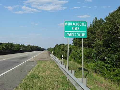 | Ousley, Georgia to Quitman, Georgia | 30°47′37″N83°27′13″W / 30.793568°N 83.453476°W / 30.793568; -83.453476 | ||
| Spook Bridge | 51.7 | Old Quitman Highway (Closed) | Blue Springs, Georgia | 30°47′23″N83°27′06″W / 30.789828°N 83.451651°W / 30.789828; -83.451651 | ||
| 51.7 | CSX Transportation Line was formerly known as the Atlantic and Gulf Railroad | 30°47′34″N83°27′12″W / 30.792882°N 83.453391°W / 30.792882; -83.453391 | ||||
| Spains Bridge/Ferry | Historically Spains Ferry Road (Defunct) | Spains Ferry | 30°44′57″N83°28′57″W / 30.749137°N 83.482455°W / 30.749137; -83.482455 | |||
| Knights Bridge/Ferry | Historically Knights Ferry Road (Defunct) | Knights Ferry | 30°42′40″N83°27′17″W / 30.711146°N 83.454755°W / 30.711146; -83.454755 | |||
| Rocky Ford Bridge | 36.7 | Rocky Ford Road/Clyattville-Nankin Road | Rocky Ford | 30°40′30″N83°23′40″W / 30.674944°N 83.394416°W / 30.674944; -83.394416 | ||
Georgia – Florida | ||||||
| 31.1 | Valdosta Railway (Closed 1973) |  | 30°38′12″N83°21′02″W / 30.636634°N 83.350468°W / 30.636634; -83.350468 | |||
Georgia | ||||||
| Horns Ferry Bridge | 27.8 |  SR 31 SR 31 |  | Clyattville, Georgia to Pinetta, Florida | 30°38′07″N83°18′42″W / 30.635379°N 83.311598°W / 30.635379; -83.311598 | |
| Old Horns Ferry Bridge | 27.7 | (Built 1895, closed 1940, defunct) | Clyattville, Georgia to Pinetta, Florida | 30°38′07″N83°18′35″W / 30.635298°N 83.309595°W / 30.635298; -83.309595 | ||
Florida | ||||||
| 22.4 |  SR 150 SR 150 |  | Bellville, Florida | 30°35′48″N83°15′35″W / 30.596707°N 83.259861°W / 30.596707; -83.259861 | ||
| 22.3 | (Defunct) | Bellville, Florida | 30°35′45″N83°15′34″W / 30.595830°N 83.259471°W / 30.595830; -83.259471 | |||
| (Defunct) | Madison Blue Spring State Park | 30°28′58″N83°14′37″W / 30.482897°N 83.243676°W / 30.482897; -83.243676 | ||||
| 12.0 |  SR 6 SR 6 | Madison Blue Spring State Park | 320016 | 30°28′56″N83°14′36″W / 30.482288°N 83.243448°W / 30.482288; -83.243448 | ||
| West Bridge | 2.3 |  SR 141 SR 141 |  | 30°24′37″N83°10′48″W / 30.410215°N 83.179994°W / 30.410215; -83.179994 | ||
Notes
- ↑U.S. Geological Survey. National Hydrography Dataset high-resolution flowline data. The National Map, accessed April 18, 2011
- ↑Simpson, J. Clarence (1956). Mark F. Boyd (ed.). Florida Place-Names of Indian Derivation. Tallahassee, Florida: Florida Geological Survey.
- ↑Martin, Jack B.; Mauldin, Margaret McKane (2004-12-01). A Dictionary of Creek/Muskogee. U of Nebraska Press. p. 183. ISBN 0803283024.
- ↑"Sponsors up and down I-75 on Water Trail Brochures | WWALS Watershed Coalition (WWALS) is Suwannee RIVERKEEPER®".
External links
- Withlacoochee River (North) Canoe Trail at Florida Department of Environmental ProtectionArchived 2017-10-20 at the Wayback Machine
- Rivers that flow north at EcoFlorida
- Withlacoochee River (North): Georgia State Line to Suwannee River State Park at Trails.com
30°23′14.2″N83°10′17.9″W / 30.387278°N 83.171639°W / 30.387278; -83.171639
- Rivers of Georgia (U.S. state)
- Rivers of Florida
- Rivers of Brooks County, Georgia
- Rivers of Berrien County, Georgia
- Rivers of Cook County, Georgia
- Bodies of water of Suwannee County, Florida
- Rivers of Lowndes County, Georgia
- Tributaries of the Suwannee River
- Georgia (U.S. state) river stubs
- North Central Florida geography stubs
- Florida river stubs