
معركة كولم



[[Siege of Danzig (1813)]] from 16 January to 29 November 1813
\", \"description\": \" ([https://geohack.toolforge.org/geohack.php?params=54.37;18.63_dim:2000 54.37,18.63])\", \"marker-symbol\": \"-number-F654\", \"marker-size\": \"medium\", \"marker-color\": \"#000080\" }, \"geometry\": {\"type\": \"Point\", \"coordinates\": [18.63,54.37] } }, { \"type\": \"Feature\", \"properties\": { \"title\": \"2
[[Battle of Möckern]] on 5 April 1813
\", \"description\": \" ([https://geohack.toolforge.org/geohack.php?params=52.14;11.95_dim:2000 52.14,11.95])\", \"marker-symbol\": \"-number-F654\", \"marker-size\": \"medium\", \"marker-color\": \"#000080\" }, \"geometry\": {\"type\": \"Point\", \"coordinates\": [11.95,52.14] } }, { \"type\": \"Feature\", \"properties\": { \"title\": \"3
[[Battle of Lützen (1813)]] on 2 May 1813
\", \"description\": \" ([https://geohack.toolforge.org/geohack.php?params=51.22;12.18_dim:2000 51.22,12.18])\", \"marker-symbol\": \"-number-F654\", \"marker-size\": \"medium\", \"marker-color\": \"#800000\" }, \"geometry\": {\"type\": \"Point\", \"coordinates\": [12.18,51.22] } }, { \"type\": \"Feature\", \"properties\": { \"title\": \"4
[[Battle of Bautzen (1813)]] from 20 to 21 May 1813
\", \"description\": \" ([https://geohack.toolforge.org/geohack.php?params=51.18;14.42_dim:2000 51.18,14.42])\", \"marker-symbol\": \"-number-F654\", \"marker-size\": \"medium\", \"marker-color\": \"#800000\" }, \"geometry\": {\"type\": \"Point\", \"coordinates\": [14.42,51.18] } }, { \"type\": \"Feature\", \"properties\": { \"title\": \"5
[[Battle of Haynau]] on 26 May 1813
\", \"description\": \" ([https://geohack.toolforge.org/geohack.php?params=51.27;15.93_dim:2000 51.27,15.93])\", \"marker-symbol\": \"-number-F654\", \"marker-size\": \"medium\", \"marker-color\": \"#000080\" }, \"geometry\": {\"type\": \"Point\", \"coordinates\": [15.93,51.27] } }, { \"type\": \"Feature\", \"properties\": { \"title\": \"6
[[Battle of Luckau]] on 4 June 1813
\", \"description\": \" ([https://geohack.toolforge.org/geohack.php?params=51.85;13.72_dim:2000 51.85,13.72])\", \"marker-symbol\": \"-number-F654\", \"marker-size\": \"medium\", \"marker-color\": \"#000080\" }, \"geometry\": {\"type\": \"Point\", \"coordinates\": [13.72,51.85] } }, { \"type\": \"Feature\", \"properties\": { \"title\": \"7
[[Battle of Großbeeren]] on 23 August 1813
\", \"description\": \" ([https://geohack.toolforge.org/geohack.php?params=52.35;13.3_dim:2000 52.35,13.3])\", \"marker-symbol\": \"-number-F654\", \"marker-size\": \"medium\", \"marker-color\": \"#000080\" }, \"geometry\": {\"type\": \"Point\", \"coordinates\": [13.3,52.35] } }, { \"type\": \"Feature\", \"properties\": { \"title\": \"8
[[Battle of the Katzbach]] on 26 August 1813
\", \"description\": \" ([https://geohack.toolforge.org/geohack.php?params=51.1;16.1_dim:2000 51.1,16.1])\", \"marker-symbol\": \"-number-F654\", \"marker-size\": \"medium\", \"marker-color\": \"#000080\" }, \"geometry\": {\"type\": \"Point\", \"coordinates\": [16.1,51.1] } }, { \"type\": \"Feature\", \"properties\": { \"title\": \"9
[[Battle of Dresden]] from 26 to 27 August 1813
\", \"description\": \" ([https://geohack.toolforge.org/geohack.php?params=51.03;13.73_dim:2000 51.03,13.73])\", \"marker-symbol\": \"-number-F654\", \"marker-size\": \"medium\", \"marker-color\": \"#800000\" }, \"geometry\": {\"type\": \"Point\", \"coordinates\": [13.73,51.03] } }, { \"type\": \"Feature\", \"properties\": { \"title\": \"10
Battle of Kulm from 29 to 30 August 1813
\", \"description\": \" ([https://geohack.toolforge.org/geohack.php?params=50.69;13.94_dim:2000 50.69,13.94])\", \"marker-symbol\": \"-number-F654\", \"marker-size\": \"medium\", \"marker-color\": \"#000000\" }, \"geometry\": {\"type\": \"Point\", \"coordinates\": [13.94,50.69] } }, { \"type\": \"Feature\", \"properties\": { \"title\": \"11
[[Battle of Dennewitz]] on 6 September 1813
\", \"description\": \" ([https://geohack.toolforge.org/geohack.php?params=51.97;13_dim:2000 51.97,13])\", \"marker-symbol\": \"-number-F654\", \"marker-size\": \"medium\", \"marker-color\": \"#000080\" }, \"geometry\": {\"type\": \"Point\", \"coordinates\": [13,51.97] } }, { \"type\": \"Feature\", \"properties\": { \"title\": \"12
[[Battle of the Göhrde]]on 16 September 1813
\", \"description\": \" ([https://geohack.toolforge.org/geohack.php?params=53.15;10.84_dim:2000 53.15,10.84])\", \"marker-symbol\": \"-number-F654\", \"marker-size\": \"medium\", \"marker-color\": \"#000080\" }, \"geometry\": {\"type\": \"Point\", \"coordinates\": [10.84,53.15] } }, { \"type\": \"Feature\", \"properties\": { \"title\": \"13
[[Battle of Altenburg]] on 28 September 1813
\", \"description\": \" ([https://geohack.toolforge.org/geohack.php?params=50.99;12.43_dim:2000 50.99,12.43])\", \"marker-symbol\": \"-number-F654\", \"marker-size\": \"medium\", \"marker-color\": \"#000080\" }, \"geometry\": {\"type\": \"Point\", \"coordinates\": [12.43,50.99] } }, { \"type\": \"Feature\", \"properties\": { \"title\": \"14
[[Combat of Roßlau]] on 29 September 1813
\", \"description\": \" ([https://geohack.toolforge.org/geohack.php?params=51.83;12.25_dim:2000 51.83,12.25])\", \"marker-symbol\": \"-number-F654\", \"marker-size\": \"medium\", \"marker-color\": \"#000080\" }, \"geometry\": {\"type\": \"Point\", \"coordinates\": [12.25,51.83] } }, { \"type\": \"Feature\", \"properties\": { \"title\": \"15
[[Battle of Wartenburg]] on 3 October 1813
\", \"description\": \" ([https://geohack.toolforge.org/geohack.php?params=51.81;12.78_dim:2000 51.81,12.78])\", \"marker-symbol\": \"-number-F654\", \"marker-size\": \"medium\", \"marker-color\": \"#000080\" }, \"geometry\": {\"type\": \"Point\", \"coordinates\": [12.78,51.81] } }, { \"type\": \"Feature\", \"properties\": { \"title\": \"16
[[Battle of Leipzig]] from 16 to 19 October 1813
\", \"description\": \" ([https://geohack.toolforge.org/geohack.php?params=51.33;12.38_dim:2000 51.33,12.38])\", \"marker-symbol\": \"-number-F654\", \"marker-size\": \"medium\", \"marker-color\": \"#800000\" }, \"geometry\": {\"type\": \"Point\", \"coordinates\": [12.38,51.33] } }, { \"type\": \"Feature\", \"properties\": { \"title\": \"17
[[Battle of Hanau]] from 30 to 31 October 1813
\", \"description\": \" ([https://geohack.toolforge.org/geohack.php?params=50.13;8.92_dim:2000 50.13,8.92])\", \"marker-symbol\": \"-number-F654\", \"marker-size\": \"medium\", \"marker-color\": \"#800000\" }, \"geometry\": {\"type\": \"Point\", \"coordinates\": [8.92,50.13] } }, { \"type\": \"Feature\", \"properties\": { \"title\": \"18
[[Battle of Sehested]] from 10 December 1813
\", \"description\": \" ([https://geohack.toolforge.org/geohack.php?params=54.37;9.82_dim:2000 54.37,9.82])\", \"marker-symbol\": \"-number-F654\", \"marker-size\": \"medium\", \"marker-color\": \"#000080\" }, \"geometry\": {\"type\": \"Point\", \"coordinates\": [9.82,54.37] } }, { \"type\": \"Feature\", \"properties\": { \"title\": \"19
[[Siege of Hamburg]] from 24 December 1813 to 12 May 1814
\", \"description\": \" ([https://geohack.toolforge.org/geohack.php?params=53.58;9.98_dim:2000 53.58,9.98])\", \"marker-symbol\": \"-number-F654\", \"marker-size\": \"medium\", \"marker-color\": \"#000080\" }, \"geometry\": {\"type\": \"Point\", \"coordinates\": [9.98,53.58] } } ] } ]"}}">
دارت معركة كولم بالقرب من بلدة كولم ( بالتشيكية : Chlumec ) وقرية بريستانوف (التي كانت تُسمى آنذاك بريستن) في شمال بوهيميا . وقعت المعركة في الفترة من 29 إلى 30 أغسطس 1813، خلال حرب التحالف السادس . هاجم فيلق فرنسي بقيادة الجنرال دومينيك فاندام الفيلق الروسي بقيادة ألكسندر أوسترمان تولستوي في 29 أغسطس. وفي اليوم التالي، هاجم الفيلق البروسي بقيادة فريدريك فون كلايست فاندام من الخلف، بينما هاجمت التعزيزات الروسية والنمساوية الجبهة الفرنسية وانسحبت. هُزم فاندام بخسائر فادحة تراوحت بين 13000 و25000 رجل و82 مدفعًا. أنشأ فريدريك ويليام وسامًا تكريميًا لمن برزوا في المعركة، وهو صليب كولم .
خلفية
بعد انتصار الفرنسيين في دريسدن ، طارد فاندام الحلفاء المنسحبين. أرسل نابليون المارشالين غوفيون سان سير وأوغست مارمون لدعم فيلق فاندام. ومع تقدم فاندام، تولى فيلقا سان سير ومارمون مهمة مؤخرة الجيش. لحق فاندام بقوات ألكسندر إيفانوفيتش أوسترمان تولستوي بالقرب من بلدة كولم، على بُعد 8 كيلومترات (5 أميال) شمال غرب أوسيغ (التي تُعرف الآن باسم أوستي ناد لابم في جمهورية التشيك).
معركة
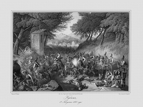
On 29 August, Vandamme, with 34,000 soldiers and 84 guns at his disposal, attacked Russian formations forming a rearguard for the retreating Coalition army, at 14,700 to 16,000[3] strong, under the command of Russian general Ostermann-Tolstoy. The situation was very dangerous for the allies; if Vandamme won the battle, the French would take the passes in the mountains, and the retreating Coalition army could be trapped by Napoleon. However, Ostermann-Tolstoy rallied all of his troops for a stiff defense; he was seriously wounded, losing his left hand, but was replaced by his subordinate Aleksei Petrovich Yermolov. By the end of the day the Allies had 20,000 men.[3] All of Vandamme's attacks were repulsed, and his situation got worse on the next day. A Prussian army corps commanded by Friedrich von Kleist attacked Vandamme's rearguard. Kleist then received help from a combined Russian and Austrian attack on his front, under the command of Generals Mikhail Bogdanovich Barclay de Tolly and von Colloredo-Mansfeld. In an attempt to repulse simultaneous attacks on his front and rear, Vandamme ordered his forces to form squares. The inexperienced French troops were unable to fend off the allies, and soon withdrew from the battlefield, with heavy losses, including Vandamme himself as a captured prisoner of war.
Casualties
The French lost between 13,000 and 25,000 of the pursuing force of 34,000, including Vandamme, and almost all of his artillery, 82 of his 84 guns, were captured. The allies lost approximately 11,000 soldiers killed or wounded.[5]
In Vandamme's corps there were two Polish regiments of Uhlans, part of cavalry divisions under the command of General Jean Corbineau. These regiments were used by Vandamme to defend against enemy cavalry charges. One regiment, commanded by Colonel Maximilian Fredro (brother of playwright Alexander Fredro), was attacked after withdrawing to a defile and surrendered. The other regiment of Uhlans, under the command of Count Tomasz Łubieński (generally known in English as Thomas Lubienski) successfully withdrew.
Aftermath
رغم أن هزيمة المارشال ماكدونالد في كاتزباخ تزامنت مع انتصار نابليون في دريسدن، إلا أن نجاح قوات التحالف في كولم قد أبطل انتصاره في نهاية المطاف، نظرًا لأن قوات نابليون لم تتمكن من سحق العدو تمامًا. وهكذا، بفوزه في هذه المعركة، نجح أوسترمان تولستوي وقواته في كسب الوقت اللازم لجيوش التحالف لإعادة تنظيم صفوفها بعد معركة دريسدن استعدادًا لمعركة فارتنبورغ ، ثم لاحقًا لمعركة لايبزيغ .
إهانات
بحسب رواية فرنسية، بعد المعركة، أُحضر فاندام إلى الإمبراطور ألكسندر الأول إمبراطور روسيا واتهمه بأنه قاطع طريق وناهب. فردّ فاندام قائلاً: "لستُ ناهباً ولا قاطع طريق، ولكن على أي حال، لن يلومني معاصريّ ولا التاريخ على قتل والدي". ويبدو أن هذا التصريح كان يُلمّح إلى الاعتقاد السائد آنذاك بأن ألكسندر الأول كان متورطاً في مقتل والده، الإمبراطور بول الأول . [ 6 ]
ساحة المعركة اليوم
معظم ساحة المعركة مبنية. يوجد نصب تذكاري كبير يعلوه تمثال أسد بجوار فندق نابليون.
ملحوظات
مراجع
- 1 2 3 4 5 6 7 بودارت 1908 ، ص. 456.
- 1 2 3 4 5 كلودفيلتر 2008 ، ص 178.
- 1 2 3 فيليشكو وآخرون. 1915 ، ص 384-388.
- ↑ إيجنبرجر 1985 ، ص 224.
- 1 2 3 ليجير 2015 ، ص. 9.
- ↑ ماربوت 2011 ، ص 375.
مصادر
- بودارت، جاستون (1908). Militär-historisches Kriegs-Lexikon (1618–1905) . تم الاسترجاع في 4 يونيو 2021 .
- كلودفيلتر، م. (2008). الحرب والنزاعات المسلحة : موسوعة إحصائية للخسائر البشرية وغيرها من الأرقام، 1494-2007 . جيفرسون، كارولاينا الشمالية: ماكفارلاند. ISBN 978-0786433193.
- ليجير، مايكل ف. (2015). نابليون والصراع من أجل ألمانيا: الحرب الفرنسية البروسية عام 1813. مطبعة جامعة كامبريدج.
- ماربو ، جان بابتيست أنطوان مارسيلين (2011). مذكرات الجنرال البارون دي ماربو . المجلد الثاني. مؤرشف من الأصل في 19 مايو 2011. تم الاطلاع عليه في 20 مايو 2021 .
- إيجنبرجر، ديفيد (1985). موسوعة المعارك . نيويورك: منشورات دوفر. ISBN 0-486-24913-1تم الاطلاع عليه بتاريخ 3 أغسطس 2023 .
- فيليشكو، كونستانتين؛ نوفيتسكي، فاسيلي؛ شوارتز، أليكسي؛ أبوشكين، فلاديمير؛ شولتز، غوستاف (1915). موسوعة سيتين العسكرية (بالروسية). المجلد. 14. نصيحة. Т-ва I.D. سيتينا . تم الاسترجاع في 1 يونيو 2023 .
للمزيد من القراءة
- نادزيجا، جادويجا (1998). ليبسك 1813 . وارسو: بيلونا. ص 57 – 59. ISBN 83-11-08826-8.
روابط خارجية
- معركة كولم
- مذكرات الدوق روفيجو
 الوسائط المتعلقة بمعركة كولم على ويكيميديا كومنز
| سبقتها معركة دريسدن | حروب نابليون معركة كولم | وتلتها معركة سان مارسيال |
- الحملة الألمانية عام 1813
- معارك حرب التحالف السادس التي شاركت فيها النمسا
- معارك حرب التحالف السادس التي شاركت فيها بروسيا
- معارك حرب التحالف السادس التي شاركت فيها روسيا
- التاريخ العسكري لجمهورية التشيك
- تاريخ منطقة أوستي ناد لابم
- معارك عام 1813
- أغسطس 1813
- القرن التاسع عشر في بوهيميا
- عام 1813 في الإمبراطورية النمساوية
- 1813 في فرنسا
- مقاطعة أوستي ناد لابم