
برج بارنابي
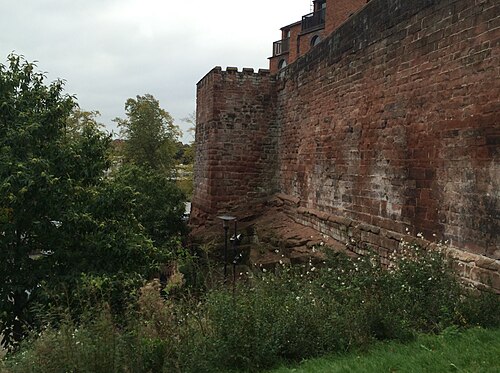
يقع برج بارنابي في الركن الجنوبي الشرقي من أسوار مدينة تشيستر ، تشيشاير ، إنجلترا. وهو مسجل في قائمة التراث الوطني لإنجلترا كمبنى مدرج من الدرجة الأولى . [ 1 ]



[[Bonewaldesthorne's Tower]]
[[File:Bonewaldesthorne's Tower.jpg|250px]]\", \"description\": \" ([https://geohack.toolforge.org/geohack.php?params=53.19267;-2.89892_dim:2000 53.19267,-2.89892])\", \"marker-symbol\": \"-number-F502948\", \"marker-size\": \"medium\", \"marker-color\": \"#1c559e\" }, \"geometry\": {\"type\": \"Point\", \"coordinates\": [-2.89892,53.19267] } }, { \"type\": \"Feature\", \"properties\": { \"title\": \"2
Spur Wall and [[Water Tower, Chester|Water Tower]]
[[File:Chester Water Tower 2.jpg|250px]]\", \"description\": \"The Water Tower is outside the northwest corner of the walls, and is joined to Bonewaldesthorne's Tower by a spur wall. ([https://geohack.toolforge.org/geohack.php?params=53.19257;-2.89957_dim:2000 53.19257,-2.89957])\", \"marker-symbol\": \"-number-F502948\", \"marker-size\": \"medium\", \"marker-color\": \"#1c559e\" }, \"geometry\": {\"type\": \"Point\", \"coordinates\": [-2.89957,53.19257] } }, { \"type\": \"Feature\", \"properties\": { \"title\": \"3
Wall between Bonewaldesthorne's Tower and Pemberton's Parlour
[[File:The city walls over the railway - geograph.org.uk - 632785.jpg|250px]]\", \"description\": \" ([https://geohack.toolforge.org/geohack.php?params=53.19288;-2.8978_dim:2000 53.19288,-2.8978])\", \"marker-symbol\": \"-number-F502948\", \"marker-size\": \"medium\", \"marker-color\": \"#1c559e\" }, \"geometry\": {\"type\": \"Point\", \"coordinates\": [-2.8978,53.19288] } }, { \"type\": \"Feature\", \"properties\": { \"title\": \"4
[[Pemberton's Parlour]]
[[File:Goblin Tower on the City Walls - geograph.org.uk - 562240.jpg|250px]]\", \"description\": \" ([https://geohack.toolforge.org/geohack.php?params=53.193;-2.89723_dim:2000 53.193,-2.89723])\", \"marker-symbol\": \"-number-F502948\", \"marker-size\": \"medium\", \"marker-color\": \"#1c559e\" }, \"geometry\": {\"type\": \"Point\", \"coordinates\": [-2.89723,53.193] } }, { \"type\": \"Feature\", \"properties\": { \"title\": \"5
Wall between Pemberton's Parlour and St Martin's Gate
[[File:Chester City Walls on the appropriately named City Wall Street (geograph 4875174).jpg|250px]]\", \"description\": \" ([https://geohack.toolforge.org/geohack.php?params=53.19307;-2.89684_dim:2000 53.19307,-2.89684])\", \"marker-symbol\": \"-number-F502948\", \"marker-size\": \"medium\", \"marker-color\": \"#1c559e\" }, \"geometry\": {\"type\": \"Point\", \"coordinates\": [-2.89684,53.19307] } }, { \"type\": \"Feature\", \"properties\": { \"title\": \"6
St Martin's Gate
[[File:St Martin's Gate, Chester (geograph 4381912).jpg|250px]]\", \"description\": \" ([https://geohack.toolforge.org/geohack.php?params=53.19319;-2.89633_dim:2000 53.19319,-2.89633])\", \"marker-symbol\": \"-number-F502948\", \"marker-size\": \"medium\", \"marker-color\": \"#1c559e\" }, \"geometry\": {\"type\": \"Point\", \"coordinates\": [-2.89633,53.19319] } }, { \"type\": \"Feature\", \"properties\": { \"title\": \"7
Wall between St Martin's Gate and Morgan's Mount
[[File:Water Tower Street and a bench mark (geograph 4699846).jpg|250px]]\", \"description\": \" ([https://geohack.toolforge.org/geohack.php?params=53.19319;-2.89603_dim:2000 53.19319,-2.89603])\", \"marker-symbol\": \"-number-F502948\", \"marker-size\": \"medium\", \"marker-color\": \"#1c559e\" }, \"geometry\": {\"type\": \"Point\", \"coordinates\": [-2.89603,53.19319] } }, { \"type\": \"Feature\", \"properties\": { \"title\": \"8
[[Morgan's Mount]]
[[File:Morgan's Mount on the city walls - geograph.org.uk - 694425.jpg|250px]]\", \"description\": \" ([https://geohack.toolforge.org/geohack.php?params=53.19328;-2.89588_dim:2000 53.19328,-2.89588])\", \"marker-symbol\": \"-number-F502948\", \"marker-size\": \"medium\", \"marker-color\": \"#1c559e\" }, \"geometry\": {\"type\": \"Point\", \"coordinates\": [-2.89588,53.19328] } }, { \"type\": \"Feature\", \"properties\": { \"title\": \"9
Wall between Morgan's Mount and Northgate
[[File:Chester City Walls (geograph 4382189).jpg|250px]]\", \"description\": \" ([https://geohack.toolforge.org/geohack.php?params=53.19351;-2.89474_dim:2000 53.19351,-2.89474])\", \"marker-symbol\": \"-number-F502948\", \"marker-size\": \"medium\", \"marker-color\": \"#1c559e\" }, \"geometry\": {\"type\": \"Point\", \"coordinates\": [-2.89474,53.19351] } }, { \"type\": \"Feature\", \"properties\": { \"title\": \"10
[[Northgate, Chester|Northgate]]
[[File:Northgate, Chester.jpg|250px]]\", \"description\": \" ([https://geohack.toolforge.org/geohack.php?params=53.1938;-2.89333_dim:2000 53.1938,-2.89333])\", \"marker-symbol\": \"-number-F502948\", \"marker-size\": \"medium\", \"marker-color\": \"#1c559e\" }, \"geometry\": {\"type\": \"Point\", \"coordinates\": [-2.89333,53.1938] } }, { \"type\": \"Feature\", \"properties\": { \"title\": \"11
Wall between Northgate and Phoenix Tower
[[File:Chester city wall and Shropshire Union Canal - geograph.org.uk - 1128122.jpg|250px]]\", \"description\": \" ([https://geohack.toolforge.org/geohack.php?params=53.1941;-2.89153_dim:2000 53.1941,-2.89153])\", \"marker-symbol\": \"-number-F502948\", \"marker-size\": \"medium\", \"marker-color\": \"#1c559e\" }, \"geometry\": {\"type\": \"Point\", \"coordinates\": [-2.89153,53.1941] } }, { \"type\": \"Feature\", \"properties\": { \"title\": \"12
[[Phoenix Tower, Chester|Phoenix Tower]]
[[File:King Charles Tower, City Walls, Chester - geograph.org.uk - 9695.jpg|250px]]\", \"description\": \" ([https://geohack.toolforge.org/geohack.php?params=53.19416;-2.89041_dim:2000 53.19416,-2.89041])\", \"marker-symbol\": \"-number-F502948\", \"marker-size\": \"medium\", \"marker-color\": \"#1c559e\" }, \"geometry\": {\"type\": \"Point\", \"coordinates\": [-2.89041,53.19416] } }, { \"type\": \"Feature\", \"properties\": { \"title\": \"13
Wall between Phoenix Tower and Kaleyard Gate
[[File:Chester City Wall (geograph 3656923).jpg|250px]]\", \"description\": \" ([https://geohack.toolforge.org/geohack.php?params=53.19363;-2.89014_dim:2000 53.19363,-2.89014])\", \"marker-symbol\": \"-number-F502948\", \"marker-size\": \"medium\", \"marker-color\": \"#1c559e\" }, \"geometry\": {\"type\": \"Point\", \"coordinates\": [-2.89014,53.19363] } }, { \"type\": \"Feature\", \"properties\": { \"title\": \"14
[[Kaleyard Gate, Chester|Kaleyard Gate]]
[[File:Kaleyard Gate 1.jpg|250px]]\", \"description\": \" ([https://geohack.toolforge.org/geohack.php?params=53.1926;-2.88963_dim:2000 53.1926,-2.88963])\", \"marker-symbol\": \"-number-F502948\", \"marker-size\": \"medium\", \"marker-color\": \"#1c559e\" }, \"geometry\": {\"type\": \"Point\", \"coordinates\": [-2.88963,53.1926] } }, { \"type\": \"Feature\", \"properties\": { \"title\": \"15
Wall between Kaleyard Gate and Eastgate
[[File:City walls and blocked doorway - geograph.org.uk - 667897.jpg|250px]]\", \"description\": \" ([https://geohack.toolforge.org/geohack.php?params=53.1914;-2.88907_dim:2000 53.1914,-2.88907])\", \"marker-symbol\": \"-number-F502948\", \"marker-size\": \"medium\", \"marker-color\": \"#1c559e\" }, \"geometry\": {\"type\": \"Point\", \"coordinates\": [-2.88907,53.1914] } }, { \"type\": \"Feature\", \"properties\": { \"title\": \"16
[[Eastgate, Chester|Eastgate]]
[[File:Eastgate.jpg|250px]]\", \"description\": \" ([https://geohack.toolforge.org/geohack.php?params=53.19087;-2.8888_dim:2000 53.19087,-2.8888])\", \"marker-symbol\": \"-number-F502948\", \"marker-size\": \"medium\", \"marker-color\": \"#1c559e\" }, \"geometry\": {\"type\": \"Point\", \"coordinates\": [-2.8888,53.19087] } }, { \"type\": \"Feature\", \"properties\": { \"title\": \"17
Wall between Eastgate and Thimbleby's Tower
[[File:A view along Chester's Walls - geograph.org.uk - 12054.jpg|250px]]\", \"description\": \" ([https://geohack.toolforge.org/geohack.php?params=53.18998;-2.88845_dim:2000 53.18998,-2.88845])\", \"marker-symbol\": \"-number-F502948\", \"marker-size\": \"medium\", \"marker-color\": \"#1c559e\" }, \"geometry\": {\"type\": \"Point\", \"coordinates\": [-2.88845,53.18998] } }, { \"type\": \"Feature\", \"properties\": { \"title\": \"18
[[Thimbleby's Tower]]
[[File:Thimbleby's Tower.jpg|250px]]\", \"description\": \" ([https://geohack.toolforge.org/geohack.php?params=53.1894;-2.88816_dim:2000 53.1894,-2.88816])\", \"marker-symbol\": \"-number-F502948\", \"marker-size\": \"medium\", \"marker-color\": \"#1c559e\" }, \"geometry\": {\"type\": \"Point\", \"coordinates\": [-2.88816,53.1894] } }, { \"type\": \"Feature\", \"properties\": { \"title\": \"19
Wall between Thimbleby's Tower and Old Newgate
[[File:Chester City Walls - geograph.org.uk - 1152340.jpg|250px]]\", \"description\": \" ([https://geohack.toolforge.org/geohack.php?params=53.18927;-2.88822_dim:2000 53.18927,-2.88822])\", \"marker-symbol\": \"-number-F502948\", \"marker-size\": \"medium\", \"marker-color\": \"#1c559e\" }, \"geometry\": {\"type\": \"Point\", \"coordinates\": [-2.88822,53.18927] } }, { \"type\": \"Feature\", \"properties\": { \"title\": \"20
Old Newgate
[[File:Old Newgate, Chester.jpg|250px]]\", \"description\": \" ([https://geohack.toolforge.org/geohack.php?params=53.18918;-2.88831_dim:2000 53.18918,-2.88831])\", \"marker-symbol\": \"-number-F502948\", \"marker-size\": \"medium\", \"marker-color\": \"#1c559e\" }, \"geometry\": {\"type\": \"Point\", \"coordinates\": [-2.88831,53.18918] } }, { \"type\": \"Feature\", \"properties\": { \"title\": \"21
[[Newgate, Chester|Newgate]]
[[File:Newgate, Chester.jpg|250px]]\", \"description\": \" ([https://geohack.toolforge.org/geohack.php?params=53.18902;-2.88819_dim:2000 53.18902,-2.88819])\", \"marker-symbol\": \"-number-F502948\", \"marker-size\": \"medium\", \"marker-color\": \"#1c559e\" }, \"geometry\": {\"type\": \"Point\", \"coordinates\": [-2.88819,53.18902] } }, { \"type\": \"Feature\", \"properties\": { \"title\": \"22
Wall between Newgate and Barnaby's Tower
[[File:Chester's City Walls - Bridgegate to Eastgate ^10 - geograph.org.uk - 375008.jpg|250px]]\", \"description\": \" ([https://geohack.toolforge.org/geohack.php?params=53.1886;-2.88797_dim:2000 53.1886,-2.88797])\", \"marker-symbol\": \"-number-F502948\", \"marker-size\": \"medium\", \"marker-color\": \"#1c559e\" }, \"geometry\": {\"type\": \"Point\", \"coordinates\": [-2.88797,53.1886] } }, { \"type\": \"Feature\", \"properties\": { \"title\": \"23
[[Barnaby's Tower]]
[[File:BarnabysTower.JPG|250px]]\", \"description\": \" ([https://geohack.toolforge.org/geohack.php?params=53.18763;-2.8875_dim:2000 53.18763,-2.8875])\", \"marker-symbol\": \"-number-F502948\", \"marker-size\": \"medium\", \"marker-color\": \"#1c559e\" }, \"geometry\": {\"type\": \"Point\", \"coordinates\": [-2.8875,53.18763] } }, { \"type\": \"Feature\", \"properties\": { \"title\": \"24
Wall between Barnaby's Tower and the Drum Tower
[[File:The walls, Chester - geograph.org.uk - 215859.jpg|250px]]\", \"description\": \" ([https://geohack.toolforge.org/geohack.php?params=53.18712;-2.88781_dim:2000 53.18712,-2.88781])\", \"marker-symbol\": \"-number-F502948\", \"marker-size\": \"medium\", \"marker-color\": \"#1c559e\" }, \"geometry\": {\"type\": \"Point\", \"coordinates\": [-2.88781,53.18712] } }, { \"type\": \"Feature\", \"properties\": { \"title\": \"25
[[Recorder's Steps]]
[[File:Recorder's Steps.jpg|250px]]\", \"description\": \" ([https://geohack.toolforge.org/geohack.php?params=53.18733;-2.88746_dim:2000 53.18733,-2.88746])\", \"marker-symbol\": \"-number-F502948\", \"marker-size\": \"medium\", \"marker-color\": \"#1c559e\" }, \"geometry\": {\"type\": \"Point\", \"coordinates\": [-2.88746,53.18733] } }, { \"type\": \"Feature\", \"properties\": { \"title\": \"26
Drum Tower
[[File:Drum Tower (cropped).jpg|250px]]\", \"description\": \" ([https://geohack.toolforge.org/geohack.php?params=53.18637;-2.88869_dim:2000 53.18637,-2.88869])\", \"marker-symbol\": \"-number-F502948\", \"marker-size\": \"medium\", \"marker-color\": \"#1c559e\" }, \"geometry\": {\"type\": \"Point\", \"coordinates\": [-2.88869,53.18637] } }, { \"type\": \"Feature\", \"properties\": { \"title\": \"27
Wall between the Drum Tower and Bridgegate
[[File:River Dee and City Wall, Chester - geograph.org.uk - 3227693.jpg|250px]]\", \"description\": \" ([https://geohack.toolforge.org/geohack.php?params=53.18629;-2.88896_dim:2000 53.18629,-2.88896])\", \"marker-symbol\": \"-number-F502948\", \"marker-size\": \"medium\", \"marker-color\": \"#1c559e\" }, \"geometry\": {\"type\": \"Point\", \"coordinates\": [-2.88896,53.18629] } }, { \"type\": \"Feature\", \"properties\": { \"title\": \"28
[[Bridgegate, Chester|Bridgegate]]
[[File:Bridgegate.jpg|250px]]\", \"description\": \" ([https://geohack.toolforge.org/geohack.php?params=53.18621;-2.88928_dim:2000 53.18621,-2.88928])\", \"marker-symbol\": \"-number-F502948\", \"marker-size\": \"medium\", \"marker-color\": \"#1c559e\" }, \"geometry\": {\"type\": \"Point\", \"coordinates\": [-2.88928,53.18621] } }, { \"type\": \"Feature\", \"properties\": { \"title\": \"29
Wall between Bridgegate and the former County Hall
[[File:Chester's City Walls - Grosvenor Road to Bridgegate ^13 - geograph.org.uk - 370045.jpg|250px]]\", \"description\": \" ([https://geohack.toolforge.org/geohack.php?params=53.18606;-2.8897_dim:2000 53.18606,-2.8897])\", \"marker-symbol\": \"-number-F502948\", \"marker-size\": \"medium\", \"marker-color\": \"#1c559e\" }, \"geometry\": {\"type\": \"Point\", \"coordinates\": [-2.8897,53.18606] } }, { \"type\": \"Feature\", \"properties\": { \"title\": \"30
Wall between former County Hall and Grosvenor Road
[[File:Chester's City Walls - Grosvenor Road to Bridgegate ^5 - geograph.org.uk - 368978.jpg|250px]]\", \"description\": \" ([https://geohack.toolforge.org/geohack.php?params=53.18496;-2.89345_dim:2000 53.18496,-2.89345])\", \"marker-symbol\": \"-number-F502948\", \"marker-size\": \"medium\", \"marker-color\": \"#1c559e\" }, \"geometry\": {\"type\": \"Point\", \"coordinates\": [-2.89345,53.18496] } }, { \"type\": \"Feature\", \"properties\": { \"title\": \"31
Wall between Grosvenor Road and Watergate
[[File:Chester racecourse - geograph.org.uk - 641229.jpg|250px]]\", \"description\": \" ([https://geohack.toolforge.org/geohack.php?params=53.18714;-2.89599_dim:2000 53.18714,-2.89599])\", \"marker-symbol\": \"-number-F502948\", \"marker-size\": \"medium\", \"marker-color\": \"#1c559e\" }, \"geometry\": {\"type\": \"Point\", \"coordinates\": [-2.89599,53.18714] } }, { \"type\": \"Feature\", \"properties\": { \"title\": \"32
[[Watergate, Chester|Watergate]]
[[File:Watergate, Chester.jpg|250px]]\", \"description\": \" ([https://geohack.toolforge.org/geohack.php?params=53.18936;-2.89739_dim:2000 53.18936,-2.89739])\", \"marker-symbol\": \"-number-F502948\", \"marker-size\": \"medium\", \"marker-color\": \"#1c559e\" }, \"geometry\": {\"type\": \"Point\", \"coordinates\": [-2.89739,53.18936] } }, { \"type\": \"Feature\", \"properties\": { \"title\": \"33
Wall between Watergate and Bonewaldesthorne's Tower
[[File:Chester City Walls from City Walls Road - geograph.org.uk - 450410.jpg|250px]]\", \"description\": \" ([https://geohack.toolforge.org/geohack.php?params=53.19086;-2.89793_dim:2000 53.19086,-2.89793])\", \"marker-symbol\": \"-number-F502948\", \"marker-size\": \"medium\", \"marker-color\": \"#1c559e\" }, \"geometry\": {\"type\": \"Point\", \"coordinates\": [-2.89793,53.19086] } }, { \"type\": \"Feature\", \"properties\": { \"title\": \"[[Chester Amphitheatre]]
\", \"description\": \" ([https://geohack.toolforge.org/geohack.php?params=53.1892;-2.887_dim:2000 53.1892,-2.887])\", \"marker-symbol\": \"-number-F502948\", \"marker-size\": \"medium\", \"marker-color\": \"#444433\" }, \"geometry\": {\"type\": \"Point\", \"coordinates\": [-2.887,53.1892] } }, { \"type\": \"Feature\", \"properties\": { \"title\": \"[[Chester Castle]]
[[File:Chester Castle - geograph.org.uk - 7346747.jpg|250px]]\", \"description\": \" ([https://geohack.toolforge.org/geohack.php?params=53.18529;-2.89261_dim:2000 53.18529,-2.89261])\", \"marker-symbol\": \"-number-F502948\", \"marker-size\": \"medium\", \"marker-color\": \"#777755\" }, \"geometry\": {\"type\": \"Point\", \"coordinates\": [-2.89261,53.18529] } }, { \"type\": \"Feature\", \"properties\": { \"title\": \"[[Chester Cathedral]]
[[File:Chester Cathedral ext Hamilton 005.JPG|250px]]\", \"description\": \" ([https://geohack.toolforge.org/geohack.php?params=53.1919;-2.8905_dim:2000 53.1919,-2.8905])\", \"marker-symbol\": \"-number-F502948\", \"marker-size\": \"medium\", \"marker-color\": \"#777755\" }, \"geometry\": {\"type\": \"Point\", \"coordinates\": [-2.8905,53.1919] } }, { \"type\": \"Feature\", \"properties\": { \"title\": \"\", \"description\": \" ([https://geohack.toolforge.org/geohack.php?params=1;1_dim:2000 1,1])\", \"marker-symbol\": \"-number-F502948\", \"marker-size\": \"medium\", \"marker-color\": \"#444433\" }, \"geometry\": {\"type\": \"Point\", \"coordinates\": [1,1] } } ] } ]"}}">
يُرجّح أن يعود تاريخ البرج إلى القرن الثالث عشر، وقد تضرر خلال الحرب الأهلية في الفترة ما بين عامي 1644 و1646 . وعندما حُوّلت أسوار المدينة إلى ممر مرتفع بين عامي 1702 و1708، أُضيف البرج ليصبح معلمًا بارزًا في هذه الزاوية. وقد خضع البرج للترميم في مناسبات متفرقة منذ ذلك الحين، وفي عامي 1879 و1880 أُجريت عليه تعديلات على نفقة أحد أعضاء مجلس المدينة. [ 1 ]
شُيّد البرج من حجارة رملية حمراء متراصة ، ويقع على نتوء صخري . ويشكل بروزًا ثلاثي الجوانب من الجدران، حيث يكون سطحه العلوي بمستوى الممر، وهو مزين بزخارف تحاكي الشرفات . ولا يوجد دليل على وجود أي حجرة في مستوى أدنى. [ 1 ]
انظر أيضاً
مراجع
- 1 2 3 هيئة التراث الإنجليزي ، "برج بارنابيز، تشيستر (1376168)" ، قائمة التراث الوطني لإنجلترا ، تم الاطلاع عليه في 7 أبريل 2012
- ↑ "أسوار وأبراج وبوابات وأبواب مدينة تشيستر" . هيئة التراث الإنجليزي . تم الاطلاع عليه بتاريخ 19 نوفمبر 2025 .
روابط خارجية
 الوسائط المتعلقة ببرج بارنابي على ويكيميديا كومنز
53°11′15″ شمالاً 2°53′15″ غرباً / 53.18763° شمالاً 2.88750° غرباً / 53.18763; -2.88750
- المباني والمنشآت في تشيستر
- مبانٍ مصنفة من الدرجة الأولى في تشيستر
- أبراج مصنفة من الدرجة الأولى
- أبراج في تشيشاير
- مخلفات المباني المدرجة في تشيشاير