
NG postcode area
Template:Attached KML/NG postcode area
KML is from Wikidata
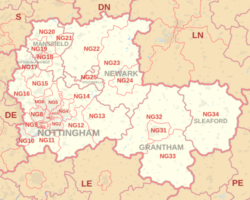
The NG postcode area, also known as the Nottingham postcode area,[2] is a group of 29 postcode districts in the East Midlands of England, within seven post towns. These cover southern and central Nottinghamshire (including Nottingham, Mansfield, Sutton-in-Ashfield, Newark-on-Trent and Southwell), parts of south-west Lincolnshire (including Grantham and Sleaford) and small parts of Derbyshire and Leicestershire. The NG postcode area is one of six with a population above 1 million.[3]
Mail for the NG postcode area is processed at Nottingham Mail Centre, along with mail for the DE postcode area.
Coverage
The approximate coverage of the postcode districts:
رسم خريطة
قالب:منطقة الرمز البريدي KML/NG المرفقة
ملف KML مأخوذ من ويكي بيانات

انظر أيضاً
مراجع
- ↑ "ملاحظات إصدار دليل الرموز البريدية الصادر عن مكتب الإحصاءات الوطنية" (ملف مضغوط) . منتجات الرموز البريدية للإحصاءات الوطنية . مكتب الإحصاءات الوطنية . مايو 2020. الجدول 2. تاريخ الاسترجاع: 19 يونيو 2020 .إحداثيات من متوسط نقاط الرموز البريدية للوحدة، "Code-Point Open" . بيانات مفتوحة من هيئة المساحة البريطانية . فبراير 2012. تم الاطلاع عليه في 21 أبريل 2012 .
- ↑ البريد الملكي، دليل إدارة العناوين ، (2004)
- ↑ "طلب حرية المعلومات: عدد السكان لكل منطقة بريدية في إنجلترا وويلز" . الأرشيف الوطني . مؤرشف من الأصل في 5 يناير 2016. تم الاطلاع عليه في 26 أبريل 2021 .
{{cite web}}: CS1 maint: bot: حالة عنوان URL الأصلي غير معروفة ( رابط )
فئات :
- نوتنغهام
- المناطق البريدية التي تغطي شرق ميدلاندز