
Umnak
Umnak (Aleut: Unmax, Umnax;[2][3]Russian: Умнак) is one of the Fox Islands of the Aleutian Islands. With 686.01 square miles (1,776.76 km2) of land area, it is the third largest island in the Aleutian archipelago and the 19th largest island in the United States. The island is home to a large volcanic caldera on Mount Okmok and the only field of geysers in Alaska. It is separated from Unalaska Island by Umnak Pass.[4][5] In 2000, Umnak was permanently inhabited by only 39 people and by 2010, around 18, placing the settlement of Nikolski in difficulty.
History
The earliest known settlement on Umnak Island is at Anangula and is 8,400 years old.[6] Anangula was later abandoned and the Sandy Beach site became occupied, along with Idaliuk and Chaluka. Most of the early settlements on Umnak were located along the streams. A major geologic event was the cutting of strand flats during the Hypsithermal period, about 8250 to 3000 years ago, which led to a greater natural food supply on the island for the settlers.[7]
Umnak Island was first reached by independent Russian fur traders in the 1750s. Abuses by the Russians led to an alliance among Aleuts in the Fox Islands. During the winter of 1761–1762, the crews of four Russian ships were massacred.[8] This included one entire crew on Umnak which was completely wiped out. Russian traders responded with a scorched-earth campaign in 1764 that essentially ended the Aleuts' independence.
Modern history
The modern history of Umnak Island is linked to the military bases established by the United States during World War II. The purpose of the forward air bases in the Aleutian Islands was not only to defend the Dutch Harbor but also to launch attacks against the Japanese mainland.[4]
On August 28, 1942, a USAAFB-17E bomber disappeared near Umnak Island, while returning from a bombing mission. The last radio contact from the crew stated that they had only one hour of fuel left. The entire crew of nine are officially listed as MIA, as no wreckage or remains were ever located.[9]
The US Navy considered Umnak as exclusive and their own. They created a camouflage in the "Blair Fish Packing Co," to build airports and bases to be used by the US Army Air Force during World War II.[4] After getting clearance from General John L. DeWitt, Simon Bolivar Buckner Jr. built airbases at Umnak (eventually known as Fort Glenn) and at Cold Bay. By the time the Japanese attacked in the summer of 1942, the US garrison at Umnak had a combined strength of 4000, including engineer companies complemented by infantry, as well as field and antiaircraft artillery units. The Japanese planned to attack and capture the island in June to maintain aerial patrols over North Pacific waters. Umnak was to be an outpost in a new area of dominance that would later include the Samoan and Fiji Islands and New Caledonia. The Japanese were unaware of the covert preparations being made by the United States as they believed that the island was only protected by a few ships operating in Aleutian waters.[4]

Geography and climate
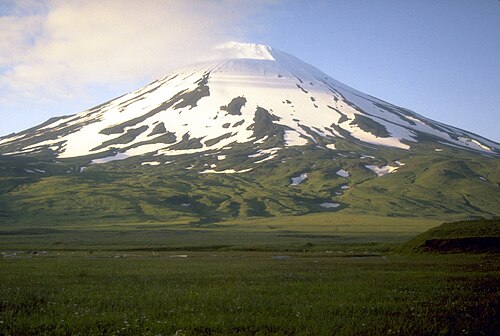
تقع جزيرة أومناك، ثالث أكبر جزر ألوشيان بعد أونيمك وأونالاسكا ، ضمن جزر فوكس في بحر بيرينغ ، جنوب غرب جزيرة أونالاسكا الأكبر . يبلغ طولها حوالي 113-116 كيلومترًا (70-72 ميلًا) وعرضها 26 كيلومترًا (16 ميلًا ) في المتوسط. [ 10 ] [ 11 ] انفصلت الجزيرة خلال العصر الجليدي الأخير ، وتقع الآن على بعد حوالي 300 كيلومتر (190 ميلًا) من سواحل أمريكا الشمالية. وهي جزيرة بركانية نشطة، تبلغ مساحتها 1793.2 كيلومترًا مربعًا (692.4 ميلًا مربعًا ) ، ويمتد ساحلها على مسافة تزيد عن 330.2 كيلومترًا (205.2 ميلًا) . ويبلغ ارتفاعها 2132 مترًا (6995 قدمًا) . [ 5 ] الجزيرة جبلية للغاية ذات غطاء نباتي منخفض. لا يوجد بها ميناء، على الرغم من وجود خليج كبير في الجزء الغربي منها، ويضم جزيرة أدوجاك . [ 4 ] [ 12 ] تُعرف النقطة الجنوبية للجزيرة باسم رأس ساجاك . [ 13 ]
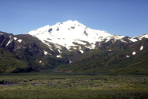
تقع أعلى قمة في الجزيرة، وهي بركان فسيفيدوف الطبقي ، في الجزء الجنوبي الغربي منها. يرتفع مخروطه المتناظر فجأة من محيطه، مشكلاً فوهة بركانية يبلغ عرضها 1.2 كيلومتر (0.75 ميل) على ارتفاع 2149 مترًا (7051 قدمًا) . [ 10 ] كان آخر ثوران له نتيجة زلزال في 9 مارس 1957. ثار البركان في 11 مارس 1957، وانتهى الثوران في اليوم التالي. [ 14 ] إلى الشرق من جبل فسيفيدوف يقع وادي خليج روسيان وبركان طبقي آخر، هو جبل ريتششنوي، الذي يتميز أيضًا بتضاريسه الوعرة وارتفاعه البالغ 1984 مترًا (6509 قدمًا) . تقع مستوطنة نيكولسكي في الجنوب الغربي، وإلى الجنوب منها تقع بحيرة أومناك التي يبلغ طولها ما يزيد قليلاً عن كيلومترين ( 1.2 ميل). [ 15 ] تقع مستوطنة تشالوكا القديمة بين هذه البحيرة ونيكولسكي. [ 16 ] تُعرف هذه المنطقة باسم ممر سامالغا ، وكانت مركزًا للنشاط القديم على الجزيرة، وتقع على بُعد حوالي 24 كيلومترًا (15 ميلًا) من الطرف الجنوبي الغربي للجزيرة (رأس ساغاك). [ 17 ]
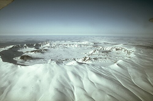
The north-northeastern part of the island contains tholeiitic basaltic rocks and is characterized by tension faulting, lava flows, and fragmental deposits of igneous rocks.[18][19] The volcano of Mount Okmok, characterized by its 5.8 miles (9.3 km) wide circular caldera, it located in the northwestern part of the island. This generally flat central basin has an average elevation of 370 m above sea level, with the rim of the caldera reaching a height of 1,073 metres (3,520 ft).[10] Following the formation of the caldera, numerous satellite cones and lava domes have formed on the flanks of the volcano. They include Mount Tulik (1,253 metres (4,111 ft)) on the caldera's southeastern slope, Mount Idak (585 metres (1,919 ft)) to the northeast, and Jag Peak.[10][20] A crater lake once filled much of the caldera to a depth of over 500 feet (150 m), but the lake ultimately drained through a notch eroded in the northeast rim. The prehistoric lake attained a maximum depth of about 150 metres (490 ft) and the upper surface reached an elevation of about 475 metres (1,558 ft), at which point it overtopped the low point of the caldera rim. Small, shallow remnants of the lake remained north of Cone D at an altitude of about 1,075 feet (328 m): a small shallow lake located between the caldera rim and Cone D; a smaller lake (named Cone B Lake) farther north near the caldera's gate. After the 2008 eruption, the hydrogeology of the caldera was greatly changed with five separate sizable lakes now emplaced. In addition to the caldera lakes, Cone A, Cone E, and Cone G and the new 2008 vent on Cone D contain small crater lakes. The volcano is currently rated by the Alaska Volcano Observatory as Aviation Alert Level Green and Volcanic-alert Level Normal.
To the north of Mount Recheshnoi, in the valley of Geyser Creek are located geothermal fields with geysers. In 1988 there were active 5 geysers up to 2 m high and 9 natural fountains up to 0.7 m high.[21]
Umnak has a subarctic climate (Köppen: Dfc), which borders on a subpolar oceanic climate (Köppen: Cfc) with short, mild to warm summers and long, cold, snowy winters.
| Climate data for Umnak, Alaska | |||||||||||||
|---|---|---|---|---|---|---|---|---|---|---|---|---|---|
| Month | Jan | Feb | Mar | Apr | May | Jun | Jul | Aug | Sep | Oct | Nov | Dec | Year |
| Record high °F (°C) | 46(8) | 49(9) | 46(8) | 50(10) | 59(15) | 64(18) | 70(21) | 74(23) | 64(18) | 60(16) | 55(13) | 46(8) | 74(23) |
| Mean daily maximum °F (°C) | 36.9(2.7) | 33.2(0.7) | 37.9(3.3) | 40.6(4.8) | 45.1(7.3) | 50.0(10.0) | 54.9(12.7) | 55.6(13.1) | 52.0(11.1) | 44.9(7.2) | 39.3(4.1) | 36.8(2.7) | 43.9(6.6) |
| Daily mean °F (°C) | 33.3(0.7) | 28.9(−1.7) | 33.8(1.0) | 36.2(2.3) | 40.3(4.6) | 45.2(7.3) | 49.4(9.7) | 50.1(10.1) | 45.9(7.7) | 39.9(4.4) | 35.2(1.8) | 32.4(0.2) | 39.2(4.0) |
| Mean daily minimum °F (°C) | 29.6(−1.3) | 24.6(−4.1) | 29.6(−1.3) | 31.8(−0.1) | 35.4(1.9) | 40.3(4.6) | 43.8(6.6) | 44.7(7.1) | 39.8(4.3) | 33.8(1.0) | 31.1(−0.5) | 27.9(−2.3) | 34.4(1.3) |
| Record low °F (°C) | 8(−13) | 10(−12) | 8(−13) | 18(−8) | 24(−4) | 30(−1) | 34(1) | 32(0) | 26(−3) | 18(−8) | 20(−7) | 16(−9) | 8(−13) |
| Average precipitation inches (mm) | 4.05(103) | 1.86(47) | 2.04(52) | 2.00(51) | 2.97(75) | 2.37(60) | 3.49(89) | 5.40(137) | 4.85(123) | 5.78(147) | 4.35(110) | 2.87(73) | 42.02(1,067) |
| Average snowfall inches (cm) | 5.2(13) | 12.0(30) | 10.3(26) | 4.9(12) | 1.7(4.3) | 0.0(0.0) | 0.0(0.0) | 0.0(0.0) | 0.1(0.25) | 2.9(7.4) | 6.1(15) | 9.6(24) | 52.8(134) |
| Source: WRCC[22] | |||||||||||||
Eruptions
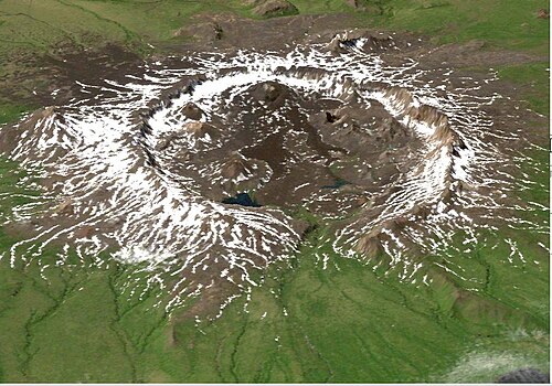
On Saturday, July 12, 2008, Okmok Volcano on Mount Okmok, located on Umnak, erupted for several days, through a fresh vent sending wet, ash, and gas-rich plume that reached an altitude of 50,000 feet (15,000 m) in the air and forcing the evacuation of Fort Glenn, a private cattle ranch located on the island. Ash fell not only on the eastern part of the island but also on a fishing village 65 miles (105 km) on the northeast. However, the Aleut village, Nikolski, on the opposite side of Umnak Island with a population of about 40 people to the west of Okmok Volcano escaped from the southeasterly path of the ash clouds. The ash plume also disrupted the operation of flights to the Dutch Harbor airport as it spread across many miles of the North Pacific.[23][24]
Okmok Caldera itself had been formed and reshaped in two major eruptions which occurred 12,000 and 2,000 years ago. Direct observations of later volcanic activity are known since 1805, with 16 eruptions recorded every 10 to 20 years.[23] The 1817 eruption deposited several feet of ash and "scoria" rock debris on the northeastern caldera rim, with ash falling on Unalaska Island. Floods that occurred during this destroyed an Aleut village at Cape Tanak on the northeast Bering Sea Coast of the island.[24] In the recent 1997 eruption, the ash clouds traveled 6 miles (9.7 km) across the volcano's caldera floor.[23]
Demographics

In 1941, when the island was being used as a military base by the United States, the population of the province consisted of only 50 Aleutians. As of the 2000 census,[1] the island's population further declined to 39 persons. Its only remaining community, Nikolski, comprised the island's entire population. Fort Glenn, a former major military facility on the northeast shore of the island, played an instrumental role in the North Pacific Theater in World War II.
As of the census of 2000,[25] there were 15 households and 12 families residing on the island. The population density was 0.3 inhabitants per square mile (0.1/km2). There were 28 housing units at an average density of 0.2 per square mile (0.08/km2). The racial makeup of was 30.77% White and 69.23% Native American.
There were 15 households, out of which 40.0% had children under the age of 18 living with them, 53.3% were married couples living together, 20.0% had a female householder with no husband present, and 20.0% were non-families. 20.0% of all households were made up of individuals, and none had someone living alone who was 65 years of age or older. The average household size was 2.60 and the average family size was 2.92.
In 2000, the median age was 40 years, with 35.9% under the age of 18, 30.8% from 25 to 44, 23.1% from 45 to 64, and 10.3% who were 65 years of age or older. For every 100 females there were 105.3 males. For every 100 females of age 18 and over, there were 92.3 males.
The median income for a household was $38,750, and the median income for a family was $40,250. Males had a median income of $26,250 versus $11,875 for females. The per capita income was $14,083. There were 23.5% of families and 20.7% of the population living below the poverty line, including 13.6% of under eighteens and 55.6% of those over 64.
Education
The only school on the island is in Nikolski, part of the Aleutian Region Schools. The Nikolski School serves grades K-12. Schools in rural Alaska must have at least 10 students to retain funding from the state. For the 2009–2010 school year, the Nikolski School had only nine students including a Samoan family who subsequently relocated, and was closed in 2010.[26][27] The school reopened in 2024.[28]
Transport

Umnak does not have a harbor. It does, however, have an airstrip, Nikolski Airport. Building an airport runway in the hilly terrain was a unique engineering achievement of the Army Engineers, commanded by Colonel Benjamin B. Talley. The construction work of the runway was proposed at Otter Point on the northeastern end of Umnak. Construction was started in the middle of January 1942 and was commissioned by April of the same year, being given the name Fort Glenn. Three hundred thousand square feet (28,000 square metres) of Marston Matting, a perforated-steel plating (PSP), was assembled along with other steel plates and created a flat surface for aircraft to take off and land. The runway was completed on March 31, 1942, by the 807th Unit of the Army Engineers. It was 3,000 feet (910 m) long with a width of 100 feet (30 m) sufficient for Capt. John S. Chennault's P-40 fighter aircraft in the 11th Fighter Squadron to land.[4]
The Naval Air Facility Otter Point was built next to Fort Glenn.[29]
After the war ended, Fort Glenn remained open as a refueling stop for transient aircraft in the Aleutians along with Military Air Transport Service flights using the Great Circle Route from Japan to the United States. The main runway was extended to 8,300 feet long to accommodate large, long-range aircraft. By 1946, the base maintained only a skeleton staff due to the rapid demobilization of the Army Air Forces. The last AAF personnel were withdrawn by 30 September 1947, and the base was put on inactive status and was effectively abandoned.[30] It was decommissioned in 1950 and the site was excessed between 1952–55 to the Bureau of Land Management. Many years later the airfield was added to the National Register of Historic Places as Cape Field at Fort Glenn. Some distance away, Nikolski is still served by a gravel airstrip.
See also
- Mount Vsevidof, the highest point of Umnak
- Umnak Airport
References
- 123Umnak Island: Blocks 1070 thru 1076, Census Tract 1, Aleutian Islands West Census Area, Alaska United States Census Bureau
- ↑William Bright Native American placenames of the United States, University of Oklahoma Press, 2004, ISBN 0-8061-3598-0 p. 347
- ↑K. Bergsland (1994). Aleut Dictionary. Fairbanks: Alaska Native Language Center. ISBN 1-55500-047-9.
- ١ ٢ ٣ ٤ ٥ ٦ "أين تقع قاعدة المقاتلات؟" . الصفحة الرئيسية لـ "أومناك". مؤرشف من الأصل في ١٦ مارس ٢٠١١. تم الاطلاع عليه في ٢٢ نوفمبر ٢٠١٠ .
- 1 2 "جزر الولايات المتحدة الأمريكية" . أومناك [447] . برنامج الأمم المتحدة للبيئة . تم الاطلاع عليه في 22 نوفمبر 2010 .
- ↑ روبرت ف. بلاك (1976). "جيولوجيا جزيرة أومناك، جزر ألوشيان الشرقية وعلاقتها بالأليوت". مجلة البحوث القطبية والألبية . 8 (1): 7-35 . doi : 10.2307/1550607 . JSTOR 1550607 .
- ↑ آر إف بلاك (1975). "العمليات الجيومورفولوجية في أواخر العصر الرباعي: آثارها على سكان أليوت القدماء في جزيرة أومناك في جزر ألوشيان" (ملف PDF) . القطب الشمالي . 28 (3): 159. doi : 10.14430/arctic2830 . مؤرشف من الأصل (ملف PDF) بتاريخ 30 يونيو 2020. تم الاطلاع عليه بتاريخ 31 ديسمبر 2007 .
- ↑ ليديا بلاك (2004). الروس في ألاسكا . فيربانكس: مطبعة جامعة ألاسكا. ISBN 1-889963-05-4.
- ↑ PacificWrecks.com. "حطام المحيط الهادئ" . pacificwrecks.com . تم الاطلاع عليه بتاريخ 30 أغسطس 2024 .
- 1 2 3 4 "أومناك" . أوشن دوتس، موسوعة الجزر. مؤرشف من الأصل في 23 ديسمبر 2010. تم الاطلاع عليه في 22 نوفمبر 2010 .
- ↑ دليل الملاحة الساحلية للولايات المتحدة. ألاسكا. الجزء الثاني. من خليج ياكوتات إلى المحيط المتجمد الشمالي . هيئة المسح الساحلي والجيوديسي الأمريكية، BiblioBazaar, LLC. 2009. ص 216. ISBN 978-1-113-48946-3.
- ↑ الموسوعة البريطانية؛ أو قاموس الفنون والعلوم والأدب المتنوع، المجلد 9. الموسوعة البريطانية ، بيل وماكفاركوهار. 1797. ص 433.
- ↑ "رأس ساغاك" . أسماء جغرافية . تم الاسترجاع في 22 نوفمبر 2010 .
- ↑ تم الإبلاغ عن نشاط Vsevidof . avo.alaska.edu
- ↑ كالفن ج. هيوسر (1973). الغطاء النباتي بعد العصر الجليدي في جزيرة أومناك، جزر ألوشيان، ألاسكا . قسم علم الأحياء، جامعة نيويورك.
- ↑ ميلفين إمبر وبيتر ن. بيرغرين، محرران. (2001). موسوعة ما قبل التاريخ: القطب الشمالي وشبه القطب الشمالي . المجلد 6: القطب الشمالي وشبه القطب الشمالي. سبرينغر. ص 10. ISBN 0-306-46256-7.
- ↑ كريستي جينتري تيرنر (1967). أسنان شعوب القطب الشمالي . جامعة ويسكونسن . ص 15-16 .
- ↑ فيكتور فاكير (1963). تفسير الخرائط المغناطيسية الجوية، المجلد 47 من الجمعية الجيولوجية الأمريكية . الجمعية الجيولوجية الأمريكية . ص 11.
- ↑ النشرة، المجلد 72، الجزء 1. الجمعية الجيولوجية الأمريكية . 1961. ص 124.
- ↑ أوكموك ، البرنامج العالمي للبراكين — قسم علوم المعادن — المتحف الوطني للتاريخ الطبيعي — مؤسسة سميثسونيان
- ↑ "حقول ينابيع جبل ريششنوي الحارة، أومناك" . وندرموندو. 4 مايو 2012. مؤرشف من الأصل في 7 يناير 2014. تم الاطلاع عليه في 4 مايو 2012 .
- ↑ "أومناك، ألاسكا (509551)" . المركز الإقليمي الغربي للمناخ . تم الاطلاع عليه في 8 يوليو 2022 .
- 1 2 3 "ثوران بركان في ألاسكا؛ إجلاء سكان الجزيرة" . رويترز . 13 يوليو/تموز 2008. تم الاطلاع عليه بتاريخ 22 نوفمبر/تشرين الثاني 2010 .
- 1 2 "ثوران بركاني هائل لبركان أوكموك في ألاسكا" . ساينس ديلي. 21 يوليو 2008. تم الاطلاع عليه بتاريخ 22 نوفمبر 2010 .
- ↑ "موقع مكتب الإحصاء الأمريكي" . مكتب الإحصاء الأمريكي . تم الاطلاع عليه بتاريخ 31 يناير 2008 .
- ↑ ويليام ياردلي (25 نوفمبر 2009). "مدارس ألاسكا الريفية تقاوم الانقراض" . صحيفة نيويورك تايمز . تم الاطلاع عليه بتاريخ 22 نوفمبر 2010 .
- ↑ إريك أولسن (25 نوفمبر 2009). "قرية ألاسكية في أزمة" . صحيفة نيويورك تايمز . مؤرشف من الأصل في 25 يونيو 2012. تم الاطلاع عليه في 22 نوفمبر 2010 .
- ↑ ستيوارت-راسي، صوفيا (10 يونيو 2025). "يقول مدير مدرسة نيكولسكي إن عام إعادة افتتاح المدرسة كان "ناجحًا للغاية" . KUCB . تم الاطلاع عليه بتاريخ 4 أبريل 2026 .
- ↑ وثيقة AFHRA رقم 00001996
روابط خارجية
- الصفحة الرئيسية لأمناك
- العمليات الجيومورفولوجية في أواخر العصر الرباعي: آثارها على سكان أليوت القدماء في جزيرة أومناك بجزر ألوشيان. مؤرشف بتاريخ 30 يونيو 2020 في أرشيف الإنترنت (Wayback Machine).
- ثوران بركان ناءٍ في ألاسكا، يقذف الصخور والرماد
53°13′26″ شمالاً 168°25′55″ غرباً / 53.22389° شمالاً 168.43194° غرباً / 53.22389; -168.43194
- أومناك
- جزر فوكس (ألاسكا)
- منطقة تعداد غرب جزر ألوشيان، ألاسكا
- جزر مقاطعة غير منظمة، ألاسكا
- جزر ألاسكا
- منشآت سابقة تابعة للبحرية الأمريكية