
Imereti
Imereti (Georgian: იმერეთი, pronounced[imeɾetʰi]) is a region of Georgia situated in the central-western part of the republic along the middle and upper reaches of the Rioni River. Imereti is the most populous region in Georgia. It consists of 11 municipalities and the city of Kutaisi, which is the capital of the region.
Subdivisions
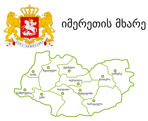
The Imereti region has one self governing city (Kutaisi) and 11 municipalities with 163 administrative communities (temi), totalling to 549 populated settlements:
- Eleven cities: Baghdati, Chiatura, Khoni, Kutaisi, Sachkhere, Samtredia, Terjola, Tkibuli, Tsqaltubo, Vani and Zestaponi;
- Three dabas: Kharagauli, Kulashi and Shorapani;
- Villages: 535
Economy
Aside from the capital Kutaisi, significant towns and regional centres include Samtredia, Chiatura (manganese production centre), Tkibuli (coal mining centre), Zestaponi (known for metals production), Vani, Khoni, and Sachkhere. Traditionally, Imereti is an agricultural region, known for its mulberries and grapes.
Demographics
The Imeretians (Georgian: იმერლები) are one of the ethnographic groups of Georgians, inhabiting Imereti. Imeretians are Orthodox Christians and speak the Imeretian dialect, one of the Northwest dialects of the Georgian language.[5] It is itself subdivided into Upper and Lower Imeretian.[6]
| Demographic history of the Imereti region[7] | ||||||||||||||||||
|---|---|---|---|---|---|---|---|---|---|---|---|---|---|---|---|---|---|---|
| 1959 | 1970 | 1979 | 1989 | 2002* | 2002** | 2014 | 2021 | |||||||||||
| Imereti |  651,959 651,959 | 718,558 | 739,189 | 772,251 |  699,410 699,410 | 632,126 | 533,906 | 481,473 | ||||||||||
| City of Kutaisi | 128,203 | 162,787 | 194,297 | 234,870 | 185,965 | - | 147,635 | 134,378 | ||||||||||
| بلدية بغدادي | 29,560 | 30,973 | 30,056 | 29,053 | 29235 | - | 21,582 | 18363 | ||||||||||
| بلدية شياتورا | 64,562 | 72,059 | 69,582 | 68,501 | 56,341 | - | 39,884 | 38,231 | ||||||||||
| بلدية خاراجولي | 36,486 | 35,591 | 31,948 | 28,702 | 27885 | - | 19473 | 18,571 | ||||||||||
| بلدية خوني | 32,548 | 32,718 | 37,968 | 34,979 | 31,749 | - | 23,570 | 21123 | ||||||||||
| بلدية ساشخيري *** | 38202 | 45,552 | 44,859 | 44,968 | 46,590 | - | 37,775 | 34,848 | ||||||||||
| بلدية سامتريديا | 62,556 | 67,141 | 65,400 | 64,504 | 60,456 | - | 48,562 | 43,448 | ||||||||||
| بلدية تيرجولا | 43,847 | 46,438 | 44,709 | 44,019 | 45,496 | - | 35,563 | 31,427 | ||||||||||
| بلدية تكيبولي | 44,411 | 42,733 | 39,451 | 36,686 | 31132 | - | 20839 | 17898 | ||||||||||
| بلدية تسكالتوبو | 62,389 | 67,086 | 69,738 | 75,061 | 73,889 | - | 56,883 | 46803 | ||||||||||
| بلدية فاني | 40,999 | 41,505 | 38,346 | 35,369 | 34,464 | - | 24,512 | 21241 | ||||||||||
| بلدية زيستابوني | 68196 | 73,975 | 72,835 | 75,539 | 76208 | - | 57,628 | 55,142 | ||||||||||
| * أظهرت الأبحاث التي أُجريت بعد تعداد عام 2014 أن تعداد عام 2002 كان مُبالغًا فيه بنسبة 8-9%. [ 8 ] **بيانات مُصححة بناءً على إسقاط رجعي للفترة 1994-2014 بالتعاون مع الأمم المتحدة [ 9 ] *** جزء من ساتشخيري يقع خارج نطاق سلطة الحكومة الجورجية ولم يُجرَ إحصاء سكانه منذ عام 2002. | ||||||||||||||||||
تاريخ

في العصور القديمة، كانت المنطقة جزءًا من مملكة كولخيس ، إلى أن غزتها مملكة بونتوس . بعد الحرب الميثريداتية الثالثة ، خضعت كولخيس لسيطرة رومانية غير مكتملة ، وحدثت فيها ثورة فاشلة عام 69 ميلادي بقيادة أنيكيتوس . [ 10 ] بعد سقوط كولخيس، تأسست مملكة لازيكا عام 131 ميلادي كدولة تابعة للرومان. كان تسات الأول أول ملك مسيحي للازيكا، [ 11 ] حيث تعمّد في القسطنطينية عام 523 ميلادي، وقاتل إلى جانب الإمبراطور الروماني الشرقي جستنيان الأول في الحرب الأيبيرية . [ 12 ] في عام 541 ميلادي، أصبحت المنطقة مسرحًا للحرب اللازية بين جستنيان الأول والإمبراطور الفارسي الساساني خسرو الأول . [ 13 ]
Between 750 and 985, Imereti was ruled by a dynasty of native princes, but was devastated by hostile incursions, reviving only after it became united to Georgia.[13] After the Mongol invasions of Georgia, Imereti was intermittently part of the independent Kingdom of Western Georgia, until being reunited in 1415 as the Duchy of Samokalako under the united Georgian Kingdom.[14] Since that kingdom's disintegration in the 15th century, Imereti was an independent kingdom from 1466 onwards.[15]
In the 17th–18th centuries, the kingdom of Imereti experienced frequent invasions by the Turks and paid patronage to the Ottoman Empire until 1810, when it was invaded and annexed by the Russian Empire. The last King of Imereti was Solomon II (1789–1810).
From 1918 to 1921, Imereti was part of the independent Democratic Republic of Georgia. Within the USSR, the region was part of the Transcaucasian SFSR from 1922 to 1936, and part of the Georgian SSR from 1936 to 1991. Since Georgian independence in 1991, Imereti has been a region of Georgia with Kutaisi as the regional capital.
See also
Notes
- South Ossetia's status is disputed. It considers itself to be an independent state, but this is recognised by only a few other countries. The Georgian government and most of the world's other states consider South Ossetia de jure a part of Georgia's territory.
- ↑South Ossetia's status is disputed. It considers itself to be an independent state, but this is recognised by only a few other countries. The Georgian government and most of the world's other states consider South Ossetia de jure a part of Georgia's territory.
- ↑Nominal area 6,680 km², de facto controlled by Georgia 6,415 km².
References
- ↑"New Governor of Imereti Appointed".
- ↑"Population and Demography - Population by cities and boroughs as of 1 January". National Statistics Office of Georgia (Geostat). Retrieved 2021-11-26.
- ↑"Regional Gross Domestic Product"(PDF).
- ↑ "مؤشر التنمية البشرية دون الوطني - قاعدة بيانات المناطق - مختبر البيانات العالمي" . hdi.globaldatalab.org . تم الاطلاع عليه بتاريخ 13 سبتمبر 2018 .
- ↑ توبتشيشفيلي، ر.، موسوعة "جورجيا"، المجلد 4، تبليسي، 2018، ص 249-250.
- ↑ كيفن تويت (1987). جغرافية اللغة الجورجية (ملف PDF) . المؤتمر الخامس للغات غير السلافية في الاتحاد السوفيتي، شيكاغو . تاريخ الاسترجاع: 27 مارس 2007 .
- ↑ "تقسيمات جورجيا" . إحصاءات السكان في أوروبا الشرقية والاتحاد السوفيتي السابق . تم الاطلاع عليه بتاريخ 4 فبراير 2022 .
- ↑ "ديناميكيات السكان في جورجيا - نظرة عامة بناءً على بيانات التعداد السكاني العام لعام 2014" (ملف PDF) . المكتب الوطني للإحصاء في جورجيا، Geostat . 29 نوفمبر 2017. الصفحات 1-4 . تاريخ الاطلاع: 4 فبراير 2022 .
- ↑ "إسقاط رجعي للمؤشرات الديموغرافية الرئيسية للفترة 1994-2014" . المكتب الوطني للإحصاء في جورجيا، Geostat . 18-05-2018. ص 3، الجدول 1. تاريخ الاسترجاع: 04-02-2022 .
- ^ وودز ، ديفيد (2006). "تاسيتوس ونيرو وأنيسيتوس" القرصان "" في لاتوموس 65 (3)
- ↑ أوديشيلي 2018 ، ص 1541.
- ↑ Greatrex & Lieu 2002 ، ص 82.
- ١ ٢ تتضمن جملة واحدة أو أكثر من الجمل السابقة نصًا من منشور أصبح الآن ملكًا عامًا : تشيشولم، هيو ، محرر (١٩١١). " إيميريتيا ". الموسوعة البريطانية . المجلد ١٤ ( الطبعة الحادية عشرة). مطبعة جامعة كامبريدج. ص ٣٣١.
- ^ بروسيه ، ماري فيليسيتي (1849). تاريخ جورجيا، منذ العصور القديمة حتى القرن التاسع عشر - الجزء الأول . سانت بطرسبرغ: أكاديمية سانت بطرسبرغ للعلوم .
- ^ بروسيه ، ماري فيليسيتي (1856). تاريخ جورجيا منذ العصور القديمة حتى القرن التاسع عشر - الجزء الثاني: التاريخ الحديث . أكاديمية سانت بطرسبرغ للعلوم.
فهرس
- جريتركس، جيفري؛ ليو، صموئيل ن. س. (2002). الحدود الشرقية الرومانية والحروب الفارسية (الجزء الثاني، 363-630 م) . لندن، المملكة المتحدة: روتليدج. ISBN 0-415-14687-9.
- أوديشيلي، مانانا (2018). "تساثيس الأول" . في نيكلسون، أوليفر (محرر). قاموس أكسفورد للعصور القديمة المتأخرة . أكسفورد: مطبعة جامعة أكسفورد. ISBN 978-0-19-866277-8.
روابط خارجية
42°10′ شمالاً 42°59′ شرقاً / 42.167° شمالاً 42.983° شرقاً / 42.167؛ 42.983
- إيميريتي
- مناطق جورجيا (الدولة)
- المقاطعات السابقة لجورجيا (الدولة)
- المناطق التاريخية في جورجيا (الدولة)