
Tiber


The Tiber (/ˈtaɪbər/TY-bər; Italian: Tevere[ˈteːvere];[1]Latin: Tiberis[2]) is the third-longest river in Italy and the longest in Central Italy, rising in the Apennine Mountains in Emilia-Romagna and flowing 406 km (252 mi) through Tuscany, Umbria, and Lazio, where it is joined by the River Aniene, to the Tyrrhenian Sea, between Ostia and Fiumicino.[3] It drains a basin estimated at 17,375 km2 (6,709 sq mi). The river has achieved lasting fame as the main watercourse of the city of Rome, which was founded on its eastern banks.
The river rises at Mount Fumaiolo in Central Italy and flows in a generally southerly direction past Perugia and Rome to meet the sea at Ostia. The Tiber has advanced significantly at its mouth, by about 3 km (2 mi), since Roman times, leaving the ancient port of Ostia Antica6 kilometres (4 miles) inland.[4][5] However, it does not form a proportional delta, owing to a strong north-flowing sea current close to the shore, due to the steep shelving of the coast, and to slow tectonic subsidence.
Sources
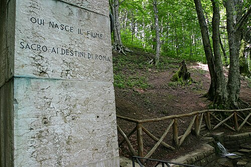
The source of the Tiber consists of two springs10 m (33 ft) away from each other on Mount Fumaiolo. These springs are called Le Vene.[6] The springs are in a beech forest 1,268 m (4,160 ft) above sea level. During the 1930s, Benito Mussolini had an antique marble Roman column built at the point where the river rises, inscribed QUI NASCE IL FIUME SACRO AI DESTINI DI ROMA ("Here is born the river / sacred to the destinies of Rome"). An eagle is on the top of the column, part of its fascist symbolism. The first kilometres of the Tiber run through Valtiberina before entering Umbria.[7]
Etymology
The genesis of the name Tiber probably was pre-Latin, like the Roman name of Tibur (modern Tivoli), and may be Italic in origin. The same root is found in the Latin praenomenTiberius. Also, Etruscan variants of this praenomen are in Thefarie (borrowed from Faliscan*Tiferios, lit. '(He) from the Tiber' < *Tiferis 'Tiber') and Teperie (via the Latin hydronym Tiber).[8][9]
Legendary king Tiberinus, ninth in the king-list of Alba Longa, was said to have drowned in the River Albula, which was afterwards called Tiberis.[8] The myth may have explained a memory of an earlier, perhaps pre-Indo-European name for the river, "white" (alba) with sediment, or "from the mountains" from pre-Indo-European word "alba, albion" mount, elevated area.[10]Tiberis/Tifernus may be a pre-Indo-European substrate word related to Aegeantifos "still water", Greek phytonymτύφη a kind of swamp and river bank weed (Typha angustifolia), IberianhydronymsTibilis, Tebro and NumidianAquae Tibilitanae.[11] Yet another etymology is from *dubri-, water, considered by Alessio as Sicel, whence the form Θύβρις later Tiberis. This root *dubri- is widespread in Western Europe e.g. Dover, Portus Dubris.[12]
History
According to legend, the city of Rome was founded in 753 BC on the banks of the Tiber about 25 km (16 mi) from the sea at Ostia. Tiber Island, in the center of the river between Trastevere and the ancient city center, was the site of an important ancient ford and was later bridged. Legend says Rome's founders, the twin brothers Romulus and Remus, were abandoned on its waters, where they were rescued by the she-wolf, Lupa.[13]
The river marked the boundary between the lands of the Etruscans to the west, the Sabines to the east and the Latins to the south. Benito Mussolini, born in Romagna, adjusted the boundary between Tuscany and Emilia-Romagna, so that the springs of the Tiber would lie in Romagna.
The Tiber was critically important to Roman trade and commerce, as ships could reach as far as 100 km (60 mi) upriver; some evidence indicates that it was used to ship grain from the Val Teverina as long ago as the fifth century BC.[4] It was later used to ship stone, timber, and foodstuffs to Rome.
During the Punic Wars of the third century BC, the harbour at Ostia became a key naval base. It later became Rome's most important port, where wheat, olive oil, and wine were imported from Rome's colonies around the Mediterranean.[4] Wharves were also built along the riverside in Rome itself, lining the riverbanks around the Campus Martius area. The Romans connected the river with a sewer system (the Cloaca Maxima) and with an underground network of tunnels and other channels, to bring its water into the middle of the city.
Wealthy Romans had garden-parks or horti on the banks of the river in Rome through the first century BC.[14] These may have been sold and developed about a century later.
The heavy sedimentation of the river made maintaining Ostia difficult, prompting the emperors Claudius and Trajan to establish a new port on the Fiumicino in the first century AD. They built a new road, the Via Portuensis, to connect Rome with Fiumicino, leaving the city by Porta Portese (the port gate). Both ports were eventually abandoned due to silting.
Several popes attempted to improve navigation on the Tiber in the 17th and 18th centuries, with extensive dredging continuing into the 19th century. Trade was boosted for a while, but by the 20th century, silting had resulted in the river only being navigable as far as Rome.[4]
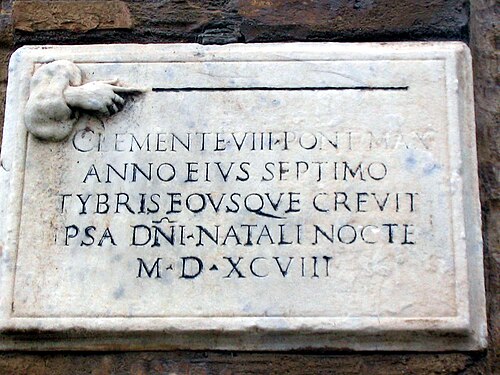
The Tiber was once known for its floods — the Campus Martius is a flood plain and would regularly flood to a depth of 2 m (6 ft 7 in). There were also numerous major floods; for example, on 15 September 1557 the river flooded to a height of 19 m (62 ft) above sea level, over 1,000 people died.[15] The river is now confined between high stone embankments, which were begun in 1876. Within the city, the riverbanks are lined by boulevards known as lungoteveri, streets "along the Tiber".
Because the river is identified with Rome, the terms "swimming the Tiber" or "crossing the Tiber" have come to be the shorthand term for converting to Roman Catholicism.[16] A Catholic who converts to Protestantism, in particular Anglicanism, is referred to as "swimming the Thames" or "crossing the Thames".[17]
في روما القديمة، كان يُلقى بالمجرمين الذين يُعدمون في نهر التيبر. ففي أواخر عهد الإمبراطور تيبيريوس ، كان يُلقى بمن يُعدمون على درج جيمونيان في نهر التيبر . واستمرت هذه العادة على مر القرون. فعلى سبيل المثال، أُلقيت جثة البابا فورموسوس في نهر التيبر بعد مجمع الجثث سيئ السمعة الذي عُقد عام 897.
الجسور
بالإضافة إلى الجسور الحديثة العديدة فوق نهر التيبر في روما، لا تزال هناك بعض الجسور القديمة (التي أصبحت الآن مخصصة للمشاة فقط في الغالب) والتي نجت جزئيًا (مثل جسر ميلفيو وجسر سانت أنجيلو )، أو كليًا ( جسر فابريسيوس ).
بالإضافة إلى الجسور، تستخدم قطارات المترو الأنفاق.
التمثيلات
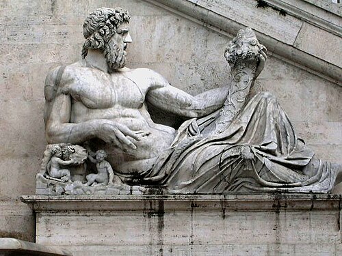
وباتباع التصوير الروماني القياسي للأنهار على أنها آلهة ذكور مستلقية ذات بنية قوية، يظهر نهر التيبر، الذي يُفسر أيضًا على أنه إله يُدعى تيبيرينوس ، مع تدفقات من الماء تتدفق من شعره ولحيته. [ 18 ]
انظر أيضاً
مراجع
- ^ ميجليوريني، برونو ؛ تاغليافيني، كارلو؛ فيوريلي، بييرو؛ بوري، توماسو فرانشيسكو، محررون. (2010) [1969]. "تيفير" . Dizionario d'Ortografia e di Pronunzia della lingua italiana (باللغة الإيطالية). روما: راي إيري . رقم ISBN 978-88-397-1478-7.
- ↑ ريتشارد جيه إيه تالبيرت، محرر. (2000). أطلس بارينغتون للعالم اليوناني والروماني: دليل الخرائط . المجلد الأول. برينستون، نيوجيرسي وأكسفورد، المملكة المتحدة: مطبعة جامعة برينستون. ص 630. ISBN 0691049459.
- ↑ لاتسيو – لاتسيو | إيطاليا. مؤرشف بتاريخ 28 أغسطس 2009 في أرشيف الإنترنت (Wayback Machine).
- 1 2 3 4 "نهر التيبر". الموسوعة البريطانية . 2006
- ↑ "نهر التيبر". الموسوعة العالمية . فيليبس، 2005.
- ↑ "ينابيع تيبر - جبل فومايولو" . turismo.fc.it . مؤرشف من الأصل بتاريخ 27 سبتمبر 2013. تم الاطلاع عليه بتاريخ 23 فبراير 2019 .
- ↑ "جولات في توسكانا - منبع نهر التيبر" . عطلات المزارع لو سيرين . مؤرشف من الأصل في 11 مايو 2010. تم الاطلاع عليه في 23 فبراير 2019 .
- 1 2 "تيبر". قاموس موجز لأسماء الأماكن في العالم . جون إيفريت هيث . مطبعة جامعة أكسفورد 2005.
- ^ جورج ديفيس تشيس، “أصل البرينومينا الرومانية”، في دراسات هارفارد في فقه اللغة الكلاسيكية ، المجلد. الثامن (1897)
- ↑ راجع. على سبيل المثال G. Alessio "Studi storico-linguisitci mesapici" في Archivio Storico Pugliese ص. 304؛ "Sul nome di Brindisi" في Archivio Storico Puglese VIII 1955 p. 211 و؛ "بوليا وكالابريا نيل كوادرو ديلا توبونوماستيكا البحر الأبيض المتوسط" في Atti del VII كونغرسو إنترناسيونالي دي ستودي أونوماستيسي فلورنسا 1962 ص. 85.
- ^ ج. سيمونيتا “La Stratificazione linguistica dell’ Agro Falisco” ص. 6 نقلا عن ج. أليسيو.
- ^ جي أليسيو “Problemi storico-linguistici mesapici” في Studi Salentini 12 1962 ص. 304.
- ↑ مور، مالكولم (21 نوفمبر 2007). "أسطورة رومولوس وريموس" . صحيفة التلغراف . مجموعة التلغراف الإعلامية المحدودة . مؤرشف من الأصل في 12 يناير 2022. تم الاطلاع عليه في 23 فبراير 2019 .
- ↑ "Horti:LacusCurtius • Gardens of Ancient Rome (Platner & Ashby, 1929)" .
- ↑ لونغ، باميلا أو. (2018). هندسة المدينة الخالدة : البنية التحتية، والطبوغرافيا، وثقافة المعرفة في روما أواخر القرن السادس عشر . شيكاغو: مطبعة جامعة شيكاغو. ص 19-20 . ISBN 978-0-226-54379-6. OCLC 1028881404 .
- ↑ ماديغام، كيفن (2010). "البابا بنديكت، والأنجليكان الساخطون، والأساقفة المنكرون للمحرقة" . نشرة هارفارد اللاهوتية . 38 (1 و2). مؤرشف من الأصل في 28 أكتوبر 2020. تم الاطلاع عليه في 16 يونيو 2022 .
- ↑ أولدر، ستيفن (2012). الرمزية : قاموس شامل ( الطبعة الثانية). جيفرسون، كارولاينا الشمالية: ماكفارلاند وشركاه. ص 202. ISBN 978-0-7864-6955-0.
- ↑ تيبر. قاموس بلومزبري للأساطير (1996)
للمزيد من القراءة
- شوناو، بيرجيت (2023). Die Geheimnisse des Tibers: Rom und eiger Fluss . ميونيخ: سي إتش بيك. رقم ISBN 9783406808371.
روابط خارجية

41°44′26″N12°14′00″E / 41.7405°N 12.2334°E / 41.7405; 12.2334
- Tiber
- Rivers of Italy
- Rivers of the Apennines
- Drainage basins of the Tyrrhenian Sea
- Waterways of Italy
- Rivers of Emilia-Romagna
- Rivers of Lazio
- Rivers of Tuscany
- Rivers of Umbria
- Geography of Rome
- Metropolitan City of Rome Capital
- Topography of the ancient city of Rome
- Rivers of the Province of Perugia
- Rivers of the Province of Rieti
- Rivers of the Province of Terni
- Rivers of the Province of Viterbo
- Rivers of the Province of Arezzo
- Rivers of the Province of Forlì-Cesena
- Rivers of the Metropolitan City of Rome Capital
- Geography of Perugia