
Fort Sumner
Fort Sumner was a military fort in New Mexico Territory charged with the internment of Navajo and Mescalero Apache populations from 1863 to 1868 at nearby Bosque Redondo.
History
On October 31, 1862, Congress authorized the construction of Fort Sumner. General James Henry Carleton initially justified the fort as offering protection to settlers in the Pecos River valley from the Mescalero Apache, Kiowa, and Comanche. He also created the Bosque Redondo reservation, a 1,600-square-mile (4,100 km2; 1,000,000-acre)[3] area where over 9,000 Navajo and Mescalero Apache were forced to live because of accusations that they were raiding white settlements near their respective homelands. The fort was named for General Edwin Vose Sumner.[4]
The reservation was to be self-sufficient, while teaching Navajo and Mescalero Apache how to be modern farmers. General Edward Canby, whom Carleton replaced, had first suggested that the Navajo people be moved to a series of reservations and be taught new skills. Some in Washington, D.C. thought that the Navajo should not be moved and that a reservation should be created on their own land. The 1865 and 1866 corn crop was sufficient, but in 1867 it was a total failure. Army officers and Indian agents realized that Bosque Redondo was a failure, as it had poor water and too little firewood for the numbers of people who were living there. The Mescalero soon ran away; the Navajo stayed longer, but were permitted to return to their native lands in May 1868.
When the Bosque Redondo was established, General Carleton ordered Colonel Kit Carson to do whatever necessary to bring first the Mescalero and then the Navajo there. All of the Mescalero Apache had been relocated by the end of 1862, but the Navajo were not resettled in large numbers until early 1864. The Navajo refer to the journey from Navajo land to the Bosque Redondo as the Long Walk. More than 300 Navajo died making the journey.[5] It was a bitter memory to many Navajo. One man described it as follows: "By slow stages we traveled eastward by present Gallup and Shushbito, Bear spring, which is now called Fort Wingate. You ask how they treated us? If there was room the soldiers put the women and children on the wagons. Some even let them ride behind them on their horses. I have never been able to understand a people who killed you one day and on the next played with your children...?"[6]
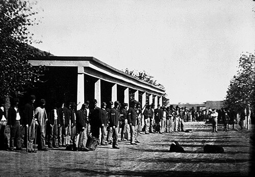
In April 1865, there were about 8,500 Navajo and 500 Mescalero Apache interned at Bosque Redondo. The Army had planned only 5,000 would be there, so lack of sufficient food was an issue from the start. As the Navajo and Mescalero Apache had long been enemies, their enforced proximity led to frequent open fighting. The environmental situation worsened. The interned people did not have clean water; it was full of alkali and there was no firewood to cook with. The water from the nearby Pecos River caused severe intestinal problems, and disease quickly spread throughout the camp. Food was in short supply because of crop failures, Army and Indian agent bungling, and criminal activities. In 1865, the Mescalero Apache, or those strong enough to travel, managed to escape. The Navajo were not allowed to leave until May 1868 when the US Army agreed that Fort Sumner and the Bosque Redondo reservation was a failure.
The 1868 Treaty of Bosque Redondo was negotiated with the Navajo and they were allowed to return to their homeland, to a "new reservation". They were joined by the thousands of Navajo who had been hiding out in the Arizona Territory hinterlands. This experience resulted in a more determined Navajo, and never again were they surprised by raiders of the Rio Grande Valley.[7] In subsequent years, they have expanded the "new reservation" into well over 16 million acres (65,000 km2).
تم التخلي عن حصن سومنر عام 1869 واشتراه لوسيان ماكسويل، صاحب مزرعة وقطب ماشية . أعاد ماكسويل بناء أحد مساكن الضباط ليصبح منزلًا من 20 غرفة. كانت ابنة ماكسويل، بوليتا ، صديقة لبيلي ذا كيد . في 14 يوليو 1881، أطلق الشريف بات غاريت النار على بيلي ذا كيد وقتله في هذا المنزل، الذي يُعرف الآن باسم منزل ماكسويل .
موقع فورت سومنر التاريخي
بعد مرور مائة عام على توقيع المعاهدة التي سمحت لشعب نافاجو بالعودة إلى ديارهم الأصلية في منطقة الزوايا الأربع ، تم إعلان حصن سومنر نصبًا تذكاريًا لولاية نيو مكسيكو في عام 1968.
تُدار هذه الملكية حاليًا من قِبل قسم المواقع التاريخية في نيو مكسيكو (المعروف سابقًا باسم قسم الآثار الحكومية) التابع لوزارة الشؤون الثقافية في نيو مكسيكو . في 4 يونيو 2005، افتُتح متحف جديد في الموقع ، صممه المهندس المعماري نافاجو ديفيد ن. سلون، تحت اسم نصب بوسك ريدوندو التذكاري . وكان الكونغرس قد أذن بإنشاء النصب التذكاري من قِبل وزير الدفاع في عام 2000، مما أتاح التمويل الفيدرالي اللازم لبنائه. [ 8 ]
يقع نصب بوسك ريدوندو التذكاري وموقع فورت سومنر التاريخي على بعد 6.5 ميل (10.5 كم) جنوب شرق فورت سومنر، نيو مكسيكو : 3 أميال (4.8 كم) شرقًا على الطريق السريع الأمريكي 60 / الطريق السريع الأمريكي 84 ، ثم 3.5 ميل (5.6 كم) جنوبًا على طريق بيلي ذا كيد.
انظر أيضاً
ملحوظات
- ↑ "نظام معلومات السجل الوطني" . السجل الوطني للأماكن التاريخية . دائرة المتنزهات الوطنية . 9 يوليو 2010.
- ↑ "نبذة عن المواقع التاريخية في نيو مكسيكو" . وزارة الشؤون الثقافية في نيو مكسيكو . مؤرشف من الأصل في 30 أكتوبر 2016. تم الاطلاع عليه في 22 ديسمبر 2016 .
- ↑ "موقع فورت سومنر التاريخي/نصب بوسك ريدوندو التذكاري" مؤرشف بتاريخ 13 يونيو 2016 على موقع Wayback Machine ، موقع مواقع نيو مكسيكو التاريخية
- ↑ https://www.newmexico.org/fort-sumner/ ، موقع ولاية نيو مكسيكو
- ↑ براون، دي. ادفن قلبي في ووندد ني: تاريخ الهنود في الغرب الأمريكي . طبعة الذكرى الثلاثين. هنري هولت وشركاه، 2000. ص 28-29.
- ↑ رجل نحيف جداً، شيخ نافاجو، نقلاً عن ريتشارد فان فالكنبورغ، مجلة الصحراء ، أبريل 1946، ص 23.
- ↑Indian Depredations in New Mexico, John S. Watts, Wash. D.C., 1858, 66 pages.
- ↑"Public Law 106-511 – Title II–Bosque Redondo Memorial". uscode.house.gov. Retrieved April 1, 2019.
References
- Bosque Redondo – destination of the long walk
- The Long Walk Trail Of The Navajos
- Thompson, Gerald (1976). The Army and the Navajo: The Bosque Redondo Reservation Experiment 1863–1868. Tucson, Arizona: The University of Arizona Press. ISBN 0-8165-0495-4
External links
- New Mexico State Historic Sites – Fort Sumner Historic Site/Bosque Redondo Memorial
- New Mexico Department of Cultural Affairs
- History of the NASA Scientific Balloon Flight Facility from which are launched stratospheric balloons each year
34°24′07″N104°11′41″W / 34.40194°N 104.19472°W / 34.40194; -104.19472
- World War II prisoner-of-war camps in the United States
- Forts in New Mexico
- Military and war museums in New Mexico
- Museums in De Baca County, New Mexico
- New Mexico Territory
- Forts on the National Register of Historic Places in New Mexico
- History of De Baca County, New Mexico
- History museums in New Mexico
- Ruins on the National Register of Historic Places
- 1863 establishments in New Mexico Territory
- 1868 disestablishments in New Mexico Territory
- National Register of Historic Places in De Baca County, New Mexico
- Internment camps in the United States
- Navajo history