
Tiwanaku
Tiwanaku (Spanish: Tiahuanaco or Tiahuanacu) is a Pre-Columbianarchaeological site in western Bolivia, near Lake Titicaca, about 70 kilometers from La Paz, and it is one of the largest sites in South America. Surface remains currently cover around 4 square kilometers and include decorated ceramics, monumental structures, and megalithic blocks. It has been conservatively estimated that the site was inhabited by 10,000 to 20,000 people in AD 800.[2]
The site was first recorded in written history in 1549 by Spanish conquistador Pedro Cieza de León while he was searching for the southern Inca capital of Qullasuyu.[3]
Bernabé Cobo, a Jesuit chronicler of Peru, reported that Tiwanaku's name once was taypiqala, which is Aymara meaning "stone in the center", alluding to the belief that it lay at the center of the world.[4] The name by which Tiwanaku was known to its inhabitants may have been lost, as they had no written language.[5][6] Heggarty and Beresford-Jones suggest that the Puquina language is most likely to have been the language of Tiwanaku.[7]
Site history
شهد تحديد تاريخ الموقع تحسينات كبيرة خلال القرن الماضي. ففي الفترة من عام 1910 إلى عام 1945، أكد آرثر بوسنانسكي أن عمر الموقع يتراوح بين 11000 و17000 عام [ 8 ] [ 9 ]، استنادًا إلى مقارنات مع العصور الجيولوجية وعلم الفلك الأثري . وفي سبعينيات القرن الماضي، اقترح كارلوس بونس سانغينيس أن الموقع سُكن لأول مرة حوالي عام 1580 قبل الميلاد [ 10 ] ، وهو أقدم تاريخ تم التوصل إليه باستخدام التأريخ بالكربون المشع. ولا يزال هذا التاريخ مستخدمًا في بعض المنشورات والمتاحف في بوليفيا. ومنذ ثمانينيات القرن الماضي، أقر الباحثون بعدم موثوقية هذا التاريخ، مما أدى إلى إجماع على أن عمر الموقع لا يتجاوز 200 أو 300 قبل الميلاد. [ 11 ] [ 12 ] [ 13 ] وفي الآونة الأخيرة، تشير دراسة إحصائية لتواريخ الكربون المشع الموثوقة إلى أن الموقع تأسس حوالي عام 110 ميلادي (50-170، باحتمالية 68%)، [ 1 ] وهو تاريخ تدعمه قلة الأنماط الخزفية من الفترات السابقة. [ 14 ]
بدأت تيواناكو نموها المطرد في القرون الأولى من الألفية الأولى الميلادية. بين عامي 375 و700 ميلادي تقريبًا، اكتسبت هذه المدينة الأنديزية أهمية بالغة. في أوج ازدهارها، امتدت مدينة تيواناكو على مساحة تقارب 4 كيلومترات مربعة (1.5 ميل مربع) وبلغ عدد سكانها أكثر من 10,000 نسمة. ويعود نمو المدينة إلى اقتصادها الزراعي الرعوي المعقد، المدعوم بالتجارة. [ 15 ]
يبدو أن الحضارة انهارت حوالي عام 1000 ميلادي، ولا يزال سبب ذلك محل نقاش. وقد أظهرت دراسات حديثة أجراها الجيولوجي إليوت أرنولد من جامعة بيتسبرغ أدلة على ازدياد الجفاف في المنطقة في ذلك الوقت. وكان من شأن الجفاف في المنطقة أن يؤثر على النظم الزراعية المحلية، وربما لعب دورًا في انهيار حضارة تيواناكو.
العلاقات
ازدادت قوة حضارة تياواناكو في حوض تيتيكاكا في الفترة ما بين 200 و500 ميلادي، وبلغت ذروتها في الفترة ما بين 500 و600 ميلادي. [ 16 ]
كانت تربط سكان تيواناكو علاقة وثيقة بحضارة واري . وتشاركت حضارتا واري وتيواناكو نفس الرموز، والتي تُعرف باسم "سلسلة الرموز الأنديزية الجنوبية". ويُفترض أن العلاقة بين الحضارتين كانت تجارية أو عسكرية. ولم تكن حضارة واري هي الحضارة الوحيدة التي يُحتمل أن تكون تيواناكو قد تواصلت معها، فقد احتوت مدن الإنكا أيضًا على أنماط معمارية وبنية تحتية مماثلة لتلك الموجودة في تيواناكو. ومن هذا، يُمكن توقع أن الإنكا استلهموا بعض الأفكار من مدينة تيواناكو وغيرها من الحضارات القديمة في حوض الأنديز.
الهياكل

The structures that have been excavated by researchers at Tiwanaku include the terraced platform moundAkapana, Akapana East, and Pumapunku stepped platforms, the Kalasasaya, the Kantatallita, the Kheri Kala, and Putuni enclosures, and the Semi-Subterranean Temple.
Some authors believe that the elites of Tiwanaku lived inside four walls that were surrounded by a moat. This theory is called "Tiwanaku moat theory". This moat, some believe, was to create the image of a sacred island. Inside the walls were many images devoted to human origin, which only the elites would see. Commoners may have entered this structure only for ceremonial purposes since it was home to the holiest of shrines.[3]
Many theories for the skill of Tiwanaku's architectural construction have been proposed. One is that they used a luk’ a, which is a standard measurement of about sixty centimeters. Jean-Pierre Protzen and Stella Nair state that "Through all our measurements, we could not only not corroborate this hypothesis, but we were unable-until now-to detect a convincing unit of measurement, or module, from which to derive other measurements either as multiples or fractions of this module." Another argument is for the Pythagorean Ratio. This idea calls for right triangles at a ratio of five to four to three used in the gateways to measure all parts. Lastly, Protzen and Nair argue that Tiwanaku had a system set for individual elements dependent on context and composition. This is shown in the construction of similar gateways ranging from diminutive to monumental size, proving that scaling factors did not affect proportion. With each added element, the individual pieces were shifted to fit together.[17]
As the population grew, occupational niches developed, and people began to specialize in certain skills. There was an increase in artisans, who worked in pottery, jewelry, and textiles. Like the later Inca, the Tiwanaku had few commercial or market institutions. Instead, the culture relied on elite redistribution.[18] That is, the elites of the state controlled essentially all economic output but were expected to provide each commoner with all the resources needed to perform his or her function. Selected occupations include agriculturists, herders, pastoralists, etc. Such separation of occupations was accompanied by hierarchical stratification within the state.[19]

Akapana
The Akapana is a "half Andean Cross"-shaped structure that is 257 m wide, 197 m broad at its maximum, and 16.5 m tall. At its center appears to have been a sunken court. This was nearly destroyed by a deep looters excavation that extends from the center of this structure to its eastern side. Material from the looter's excavation was dumped off the eastern side of the Akapana. A staircase is present on its western side. Possible residential complexes might have occupied both the northeast and southeast corners of this structure.
Akapana East
The Akapana East was built on the eastern side of early Tiwanaku. Later it was considered a boundary between the ceremonial center and the urban area. It was made of a thick, prepared floor of sand and clay, which supported a group of buildings. Yellow and red clay was used in different areas for what seems like aesthetic purposes. It was swept clean of all domestic refuse, signaling its great importance to the culture.[20]
Pumapunku
The Pumapunku is a man-made platform built on an east-west axis like the Akapana. It is a T-shaped, terraced earthen platform mound faced with megalithic blocks. It is 167.36 m wide along its north-south axis and 116.7 m broad along its east-west axis and is 5 m tall. Identical 20-meter-wide projections extend 27.6 meters north and south from the northeast and southeast corners of the Pumapunku. Walled and unwalled courts and an esplanade are associated with this structure.
A prominent feature of the Pumapunku is a large stone terrace; it is 6.75 by 38.72 meters in dimension and paved with large stone blocks. It is called the "Plataforma Lítica" and contains the largest stone block found in the Tiwanaku site.[21][22] According to Ponce Sangines, the block is estimated to weigh 131 metric tonnes.[21] The second-largest stone block found within the Pumapunku is estimated to be 85 metric tonnes.[21][22]
Scattered around the site of the Puma Punku are various types of cut stones. Due to the complexity of the stonework the site is often cited by conspiracy theorists to be a site of ancient alien intervention. These claims are entirely unsubstantiated. The most informed reconstruction of the building is based on the 3D printing and modeling by Alexei Vranich.[23]

Kalasasaya
كالاساسايا عبارة عن فناء واسع يزيد طوله عن 300 قدم، محاط ببوابة عالية. يقع شمال أكابانا وغرب المعبد شبه الجوفي. داخل هذا الفناء، عثر المستكشفون على بوابة الشمس . ومنذ أواخر القرن العشرين، افترض الباحثون أن هذا لم يكن الموقع الأصلي للبوابة.
يقع بالقرب من الفناء المعبد شبه الجوفي؛ وهو فناء مربع غائر يتميز بمحوره الشمالي الجنوبي بدلاً من الشرقي الغربي. [ 24 ] جدرانه مغطاة برؤوس نقر ذات أنماط مختلفة، مما يشير إلى إعادة استخدام المبنى لأغراض متعددة عبر الزمن. [ 25 ] بُني المعبد بجدران من أعمدة حجرية رملية وكتل أصغر من البناء الحجري المصقول . [ 25 ] [ 26 ] يُقدّر وزن أكبر كتلة حجرية في كالاساسايا بـ 26.95 طنًا متريًا. [ 21 ]
تضم العديد من مباني الموقع بوابات مهيبة؛ وتقع البوابات الضخمة منها على تلال اصطناعية أو منصات أو ساحات غائرة. تُظهر إحدى البوابات رمزًا لشخصية مواجهة في وضعية إله العصا . ويُستخدم هذا الرمز أيضًا على بعض الأواني الضخمة، مما يدل على أهميته في الحضارة. ويمكن رؤية رمز بوابة الشمس، المعروف باسم سلسلة الرموز الأنديزية الجنوبية، على العديد من المنحوتات الحجرية، وتماثيل القيرو ، وعلب التبغ ، وغيرها من القطع الأثرية التيواناكو. [ 27 ]
تُصوّر النقوش الفريدة أعلى بوابة الشمس حيوانات وكائنات أخرى. وقد زعم البعض أن هذا الرمز يُمثّل نظام تقويم خاص بشعب تيواناكو، على الرغم من عدم وجود دليل قاطع على صحة هذه النظرية.
بوابة الشمس وغيرها من البوابات الموجودة في بومابونكو غير مكتملة. فهي تفتقر إلى جزء من إطارها الغائر النموذجي المعروف باسم " شامبرانلي" ، والذي يحتوي عادةً على تجاويف للمشابك لدعم الإضافات اللاحقة. تتميز هذه الأمثلة المعمارية، بالإضافة إلى بوابة أكابانا، بتفاصيل فريدة وتُظهر مهارة عالية في نحت الحجر، مما يكشف عن معرفة بالهندسة الوصفية . ويشير انتظام العناصر إلى أنها جزء من نظام نسبي.

علم الكونيات
في العديد من ثقافات الأنديز، تُقدَّس الجبال [ 28 ] وقد تُعتبر أشياءً مقدسة. يقع موقع تيواناكو في الوادي بين جبلين مقدسين، هما بوكارا وتشوكي كاوا . في مثل هذه المعابد، كانت تُقام في العصور القديمة احتفالات لتكريم الآلهة والأرواح وتقديم الشكر لها. [ 29 ] كانت هذه المعابد أماكن للعبادة والطقوس التي ساعدت على توحيد شعوب الأنديز من خلال الرموز المشتركة ووجهات الحج .
أصبحت تيواناكو مركزًا للطقوس الدينية في حضارات ما قبل كولومبوس، سواءً للعامة أو النخب. فعلى سبيل المثال، استُخدمت التضحية البشرية في العديد من حضارات ما قبل كولومبوس لاسترضاء إلهٍ ما وجلب الحظ السعيد. وكشفت الحفريات في أكابانا بتيواناكو عن بقايا قرابين بشرية وإبلية. [ 30 ] تتضمن بعض نقوش تيواناكو رمزًا نادرًا لـ"المُضحّي" يجمع بين ملامح بشرية وإبلية، ويظهر حاملًا رأسًا تذكاريًا أو فأسًا. وقد أطلق عليه الباحثون اسم "مُضحّي الإبل في تيواناكو"، ويظهر غالبًا على قطع أثرية محمولة ذات قيمة (مثل أدوات الاستنشاق، والمنسوجات، وأنابيب العظام المنحوتة)، لا سيما في المناطق الداخلية لتيواناكو المرتبطة بشبكات قوافل الإبل. [ 31 ] يقول الباحثون إن الجمال والبشر يشتركون في مفهوم "كاماي" (جوهر/قوة الوجود)، وأن تمثال "مُضحّي الجمال" في تيواناكو يُمثّل "توكوي" (عملية التحوّل إلى شكل جديد). [ 32 ]
يتكهن الباحثون بأن أكابانا ربما استُخدمت أيضًا كمرصد فلكي. بُنيت بحيث تُحاذي قمة كيمساتشاتا ، مما يُتيح رؤية دوران درب التبانة من القطب الجنوبي. [ 33 ] وُضعت مبانٍ أخرى مثل كالاساسايا لتوفير أفضل رؤية لشروق الشمس في الاعتدالين الربيعي والخريفي، والانقلابين الصيفي والشتوي. على الرغم من أن القيمة الرمزية والوظيفية لهذه المعالم لا تزال محل تكهنات، إلا أن شعب تيواناكو كان قادرًا على دراسة وتفسير مواقع الشمس والقمر ودرب التبانة والأجرام السماوية الأخرى بدقة كافية لمنحها دورًا هامًا في هندستهم المعمارية. [ 34 ]
Aymara legends place Tiwanaku at the center of the universe, probably because of the importance of its geographical location. The Tiwanaku were highly aware of their natural surroundings and would use them and their understanding of astronomy as reference points in their architectural plans. The most significant landmarks in Tiwanaku are the mountains and Lake Titicaca.[35] The lake level of Lake Titicaca has fluctuated significantly over time. The spiritual importance and location of the lake contributed to the religious significance of Tiwanaku. In the Tiwanaku worldview, Lake Titicaca is the spiritual birthplace of their cosmic beliefs.[36] According to Incan mythology, Lake Titicaca is the birthplace of Viracocha, who was responsible for creating the sun, moon, people, and the cosmos. In the Kalasasaya at Tiwanaku, carved atop a monolith known as the Gate of the Sun, is a front-facing figure holding a spear-thrower[37] and snuff. Some speculate that this is a representation of Viracocha. However, it is also possible that this figure represents a deity that the Aymara refer to as "Tunuupa" who, like Viracocha, is associated with legends of creation and destruction.
The Aymara, who are thought to be descendants of the Tiwanaku, have a complex belief system similar to the cosmology of several other Andean civilizations. They believe in the existence of three spaces: Arajpacha, the upper world; Akapacha, the middle or inner world; and Manqhaoacha, the lower world.[38] Often associated with the cosmos and Milky Way, the upper world is considered to be where celestial beings live. The middle world is where all living things are, and the lower world is where life itself is inverted.[39]
Archaeology

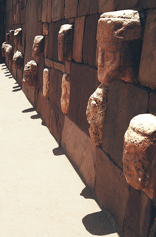
As the site has suffered from looting and amateur excavations since shortly after Tiwanaku's fall, archeologists must attempt to interpret it with the understanding that materials have been jumbled and destroyed. This destruction continued during the Spanish conquest and colonial period, and during 19th century and the early 20th century. Other damage was committed by people quarrying stone for building and railroad construction, and target practice by military personnel.
No standing buildings have survived at the modern site. Only public, non-domestic foundations remain, with poorly reconstructed walls. The ashlar blocks used in many of these structures were mass-produced in similar styles so that they could possibly be used for multiple purposes. Throughout the period of the site, certain buildings changed purposes, causing a mix of artifacts found today.[17]
Detailed study of Tiwanaku began on a small scale in the mid-nineteenth century. In the 1860s, Ephraim George Squier visited the ruins and later published maps and sketches completed during his visit. German geologist Alphons Stübel spent nine days in Tiwanaku in 1876, creating a map of the site based on careful measurements. He also made sketches and created paper impressions of carvings and other architectural features. A book containing major photographic documentation was published in 1892 by engineer Georg von Grumbkow, With commentary by archaeologist Max Uhle, this was the first in-depth scientific account of the ruins.
Von Grumbkow had first visited Tiwanaku between the end of 1876 and the beginning of 1877, when he accompanied as a photographer the expedition of French adventurer Théodore Ber, financed by American businessman Henry Meiggs, against Ber’s promise of donating the artifacts he will find, on behalf of Meiggs, to Washington's Smithsonian Institution and the American Museum of Natural History in New York. Ber’s expedition was cut short by the violent hostility of the local population, instigated by the Catholic parish priest, but von Grumbkow’s early pictures survive.[40]
- Pictures of archaeological excavations in 1903
 Stairs of Kalasasaya (1903)
 Gate of the Sun (1903)
 Gate of the Sun, Rear View (1903)
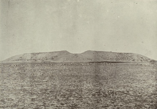 Akapana (1903); first thought to be an alluvial layer, later shown to be entirely artificial
 Semi-Subterranean Temple (1903)
Contemporary excavation and restoration
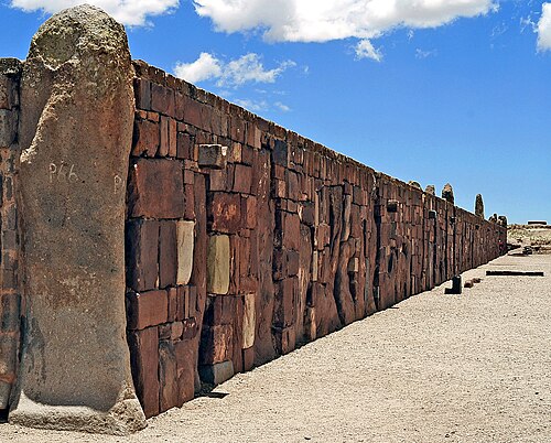

In the 1960s, the Bolivian government initiated an effort to restore the site and reconstruct part of it. The walls of the Kalasasaya are almost all reconstructed. The reconstruction was not sufficiently based on evidence. The reconstruction does not have as high quality of stonework as was present in Tiwanaku.[25] Early visitors compared Kalasasaya to Englands Stonehenge.[41] Ephraim Squier called it "American Stonehenge".[42] Before the reconstruction, it had more of a "Stonehenge"-like appearance as the filler stones between the large stone pillars were all looted.[43] As noted, the Gateway of the Sun, now in the Kalasasaya, is believed to have been moved from its original location.[3]
Modern, academically sound archaeological excavations were performed from 1978 through the 1990s by University of Chicagoanthropologist Alan Kolata and his Bolivian counterpart, Oswaldo Rivera. Among their contributions are the rediscovery of the suka kollus, accurate dating of the civilization's growth and influence, and evidence for a drought-based collapse of the Tiwanaku civilization.
Archaeologists such as Paul Goldstein have argued that the Tiwanaku empire ranged outside of the altiplano area and into the Moquegua Valley in Peru. Excavations at Omo settlements show signs of similar architecture characteristic of Tiwanaku, such as a temple and terraced mound.[24] Evidence of similar types of cranial vault modification in burials between the Omo site and the main site of Tiwanaku is also being used for this argument.[44]

Today Tiwanaku has been designated as a UNESCOWorld Heritage Site, administered by the Bolivian government.
Recently, the Department of Archaeology of Bolivia (DINAR, directed by Javier Escalante) has been conducting excavations on the terraced platform mound Akapana. The Proyecto Arqueologico Pumapunku-Akapana (Pumapunku-Akapana Archaeological Project, PAPA) run by the University of Pennsylvania, has been excavating in the area surrounding the terraced platform mound for the past few years, and also conducting Ground Penetrating Radar surveys of the area.
In former years, an archaeological field school offered through Harvard's Summer School Program, conducted in the residential area outside the monumental core, has provoked controversy amongst local archaeologists.[45] The program was directed by Gary Urton,[46] of Harvard, who was an expert on quipus, and Alexei Vranich of the University of Pennsylvania. The controversy was over allowing a team of untrained students to work on the site, even under professional supervision. It was so important that only certified professional archaeologists with documented funding were allowed access. The controversy was charged with nationalistic and political undertones.[47] The Harvard field school lasted for three years, beginning in 2004 and ending in 2007. The project was not renewed in subsequent years, nor was permission sought to do so.
In 2009 state-sponsored restoration work on Akapana was halted due to a complaint from UNESCO. The restoration had consisted of facing the platform mound with adobe, although researchers had not established this as appropriate.[48][49]

In 2013, marine archaeologists exploring Lake Titicaca's Khoa reef discovered an ancient ceremonial site and lifted artifacts such as a lapis lazuli and ceramic figurines, incense burners and a ceremonial medallion from the lake floor.[50] The artifacts are representative of the lavishness of the ceremonies and the Tiwanaku culture.[50]
When a topographical map of the site was created in 2016 by the use of drone imaging, a "set of hitherto unknown structures" was revealed. These structures spanned over 411 hectares (1,020 acres), and included a stone temple covering 17 hectares (42 acres) and about one hundred circular or rectangular structures of vast dimensions, which were possibly domestic units, as well as canal and road infrastructure.[51]
Aerial surveillance
Between 2005 and 2007 various types of aerial surveillance methods were used by UNESCO to create an aerial picture of the site. Lidar, aerial photography, drones, and terrestrial laser scanning were all used in this process. Data concluded from this research includes topographical maps that show the principal structures at the site along with mapping of multiple structures in the Mollo Kuntu area. Over 300 million data points were placed from these methods and have helped redefine main structures that have not fully been excavated such as the Puma Punku.
Important authors
Alan Kolata of the University of Chicago conducted research at Tiwanaku in the late 1900s from which he made descriptions of the City and its structure and culture in his book The Tiwanaku. He later published Valley of The Spirits which described more aspects of Tiwanaku culture such as astrology and mythology.
John Wayne Janusek of Vanderbilt University spent time in the late 1900s as well at the site of Tiwanaku recording findings of the excavations going on. In 2008 he published Ancient Tiwanaku which described his findings on the architecture, agriculture and other aspects of Tiwanaku life.
Jean-Pierre Protzen was an architecture professor of the University of California at Berkeley and spent much of his life studying the architecture of Tiwanaku. In 2013, he collaborated with Stella Nair (Art and Architecture Ph.D and professor) to publish The Stones of Tiahuanaco which gives great descriptions of the architecture and stonework seen at Tiwanaku. Their research there included experimental archeology replicating some of the stone cuts seen at the site. Their work played a major role in creating potential reconstructions of what many of the structures look like, especially the Puma Punku.
See also
References
- 12Marsh, Erik (2012). "A Bayesian Re-Assessment of the Earliest Radiocarbon Dates from Tiwanaku, Bolivia". Radiocarbon. 54 (2): 203–218. Bibcode:2012Radcb..54..203M. doi:10.2458/azu_js_rc.v54i2.15826.
- ↑Janusek, John (2004). Identity and Power in the Ancient Andes: Tiwanaku Cities through Time. New York: Routledge. p. 128. ISBN 978-0415946346.
- 123Kolata, Alan L. (1993). The Tiwanaku: Portrait of an Andean Civilization. Wiley-Blackwell. ISBN 978-1-55786-183-2.
- ↑Kelley, David H.; Milone, Eugene F. (November 19, 2004). Exploring Ancient Skies: An Encyclopedic Survey of Archaeoastronomy. Springer. ISBN 978-0-387-95310-6.
- ↑Hughes, Holly (October 20, 2008). Frommers 500 Places to See Before They Disappear (500 Places). Frommers. pp. 266. ISBN 978-0-470-18986-3. Retrieved 9 August 2009.
- ↑"Profile: Fabricio R. Santos - The Genographic project". Genographic Project. National Geographic. Archived from the original on July 5, 2011. Retrieved 2009-08-09.
- ↑Heggarty, P.; Beresford-Jones, D. (2013). "Andes: linguistic history". In Ness, I. (ed.). The Encyclopedia of Global Human Migration. Oxford: Wiley-Blackwell. pp. 401–409. doi:10.1002/9781444351071.wbeghm852. ISBN 978-1-44435-107-1.
- ↑Posnansky, Arthur (1910). Tihuanacu e islas del Sol y de la Luna (Titicaca y Koati). La Paz.
{{cite book}}: CS1 maint: location missing publisher (link) - ↑Posnansky, Arthur (1945). Tihuanacu, the Cradle of American Man. Vol. I–II. Translated by James F. Sheaver. New York: JJ Augustin.
- ↑Ponce Sanginés, Carlos (1971). Tiwanaku: Espacio, Tiempo y Cultura. La Paz: Academia Nacional de Ciencias de Bolivia.
- ↑Browman, David (1980). "Tiwanaku expansion and economic patterns". Estudios Arqueológicos. 5: 107–120.
- ↑Janusek, John (2003). "Vessels, Time, and Society: Toward a Ceramic Chronology in the Tiwanaku Heartland". In Kolata, Alan (ed.). Tiwanaku and Its Hinterland: Archaeological and Paleoecological Investigations of an Andean Civilization, Vol. 2: Urban and Rural Archaeology. Washington, D.C.: Smithsonian. pp. 30–89.
- ↑Stanish, Charles (2003). Ancient Titicaca. Los Angeles: University of California Press.
- ↑Marsh, Erik (2012). "The Founding of Tiwanaku: Evidence from Kk'araña". Ñawpa Pacha. 32: 169–188. doi:10.1179/naw.2012.32.2.69. S2CID 194040072.
- ↑Andrews, Anthony P. (1995). First Cities. Canada: St. Remy Press. pp. 158–160. ISBN 0-89599-043-1. Retrieved 26 July 2022.
- ↑Rivera-Casanovas, Claudia; Agüero, Carolina (2026), "Tiwanaku in the Titicaca Basin and Its Expansion in the South-Central Andean Region", in Aldenderfer, Mark; Sepúlveda, Marcela; Neves, Eduardo Góes (eds.), The Oxford Handbook of South American Archaeology, Oxford University Press, pp. 797–816, doi:10.1093/oxfordhb/9780195391367.013.54, ISBN 978-0-19-539136-7
- 12Protzen, J.-P., and S. E. Nair, 2000, "On Reconstructing Tiwanaku Architecture": The Journal of the Society of Architectural Historians, vol. 59, no., 3, pp. 358–371.
- ↑, Smith, Michael E. (2004), "The Archaeology of Ancient Economies," Annu. Rev. Anthrop. 33: 73-102.
- ↑Bahn, Paul G., Lost Cities. New York: Welcome Rain, 1999.
- ↑Isbell, W. H., 2004, Palaces and Politics in the Andean Middle Horizon. in S. T. Evans and J. Pillsbury, eds., pp. 191–246. Palaces of the Ancient New World, Dumbarton Oaks Research Library and Collection Washington, D.C.
- 1234Ponce Sanginés, C. and G. M. Terrazas, 1970, Acerca De La Procedencia Del Material Lítico De Los Monumentos De Tiwanaku. Publication no. 21. Academia Nacional de Ciencias de Bolivia.
- 12Vranich, A., 1999, Interpreting the Meaning of Ritual Spaces: The Temple Complex of Pumapunku, Tiwanaku, Bolivia, Doctoral Dissertation, University of Pennsylvania.
- ↑Vranich, Alexei (2018-12-13). "Reconstructing ancient architecture at Tiwanaku, Bolivia: the potential and promise of 3D printing". Heritage Science. 6 (1) 65: 1–20. doi:10.1186/s40494-018-0231-0. ISSN 2050-7445.
- 12Goldstein, Paul (1993). Tiwanaku Temples and State Expansion: A Tiwanaku Sunken-Court Temple in Moquegua, Peru.
- 123Browman, D. L., 1981, "New light on Andean Tiwanaku," New Scientist vol. 69, no. 4, pp. 408–419.
- ↑Coe, Michael, Dean Snow, and Elizabeth Benson, 1986, Atlas of Ancient America p. 190
- ↑Silverman, Helaine Andean Archaeology Volume 2. Malden, Massachusetts: Blackwell Publishing, 2004
- ↑Reinhard, Johan (1985). "Sacred Mountains: An Ethno-Archaeological Study of High Andean Ruins". Mountain Research and Development. 5 (4): 299–317. doi:10.2307/3673292. ISSN 0276-4741. JSTOR 3673292.
- ↑Bonilla, Heraclio (1 November 2006). "Religious Practices in the Andes and their Relevance to Political Struggle and Development". Mountain Research and Development. 26 (4): 336–342. doi:10.1659/0276-4741(2006)26[336:RPITAA]2.0.CO;2. ISSN 0276-4741. S2CID 128460565.
- ↑Blom, Deborah E.; Janusek, John Wayne (2004). "Making Place: Humans as Dedications in Tiwanaku". World Archaeology. 36 (1): 123–141. doi:10.1080/0043824042000192623. ISSN 0043-8243. JSTOR 4128306. S2CID 154741300.
- ↑Baitzel, Sarah I.; Trigo Rodríguez, David E. (2019). "The Tiwanaku Camelid Sacrificer: Origins and Transformations of Animal Iconography in the Context of Middle Horizon (A.D. 400–1100) State Expansion". Ñawpa Pacha: Journal of Andean Archaeology. 39 (1): 31–56.
- ↑Baitzel, Sarah I.; Trigo Rodríguez, David E. (2019). "The Tiwanaku Camelid Sacrificer: Origins and Transformations of Animal Iconography in the Context of Middle Horizon (A.D. 400–1100) State Expansion". Ñawpa Pacha: Journal of Andean Archaeology. 39 (1): 31–56.
- ↑Vranich, Alexei (2016). "Monumental Perceptions of the Tiwanaku Landscape". Political Landscapes of Capital Cities. University Press of Colorado: 181–212. doi:10.5876/9781607324690.c005. ISBN 9781607324683. JSTOR j.ctt1dfnt2b.11.
- ↑Magli, Giulio (2009). Mysteries and discoveries of archaeoastronomy : from Giza to Easter Island. New York: Copernicus Books/Springer Science + Business Media, in association with Praxis Pub. ISBN 978-0-387-76566-2.
- ↑Cartwright, Mark (5 April 2014). "Lake Titicaca". World History Encyclopedia.
- ↑"Tiwanaku and Lake Titikaka – Bolivia". Sacred Land.
- ↑Max Uhle: Wesen und Ordnung der altperuanischen Kulturen. Colloquium Verlag, 1959, p. 62: The staff in the figure's right hand clearly indicates the spear-thrower due to the hook at the top, which - as is often the case with real spear throwers - has the shape of a bird („Der Stab in der rechten Hand der Figur bezeichnet durch den am oberen Ende sitzenden Haken, der — wie so oft bei wirklichen Speerschleudern — die Gestalt eines Vogels hat, deutlich die Speerschleuder.“)
- ↑"Cosmovision of the Aymara people in Chile for trekkers". Trekkingchile EN.
- ↑Quilter, Jeffrey (2014). The ancient central Andes. Abingdon, Oxon. ISBN 9780415673105. Archived from the original on 2021-05-03. Retrieved 2021-05-04.
{{cite book}}: CS1 maint: location missing publisher (link) - ↑Riviale, Pascal (2018). "Un Communard parmi les américanistes : biographie de Théodore Ber". Bérose-Encyclopédie internationale des histoires de l'anthropologie. Bérose. Retrieved 18 January 2020.
- ↑Alfons Stübel, Max Uhle: Die Ruinenstätte von Tiahuanaco im Hochlande des alten Perú: Eine kulturgeschichtliche Studie auf Grund selbständiger Aufnahmen. Hiersemann, Leipzig 1892, Part II, p. 46 (digi.ub.uni-heidelberg.de).
- ↑Jean-Pierre Protzen, Stella Nair: The Stones of Tiahuanaco: A Study of Architecture and Construction. Vol. 75. Cotsen Institute of Archaeology Press, University of California, Los Angeles 2013, p. 46.
- ↑Alexei Vranich, Charles Stanish (eds.): Visions of Tiwanaku. UCLA Cotsen Institute of Archaeology, Los Angeles, 2013, p. 4
- ↑Hoshower, Lisa M. (1995). Artificial Cranial Deformation at the Omo M10 Site: A Tiwanaku Complex from the Moquegua Valley, Peru.
- ↑Lémuz, C (2007), "Buenos Negocios, ¿Buena Arqueologia?", Crítica Arqueológica Boliviana[Bolivian archæological critic] (World Wide Web log) (in Spanish).
- ↑"Program in Tiwanaku, Bolivia", Summer School Archives, Harvard University, 2005
{{citation}}: CS1 maint: deprecated archiveal service ( link ) . - ↑ كوجان، ديفيد؛ أنجيلو، دانتي (2005)، "الروايات السائدة، والعنف الاجتماعي، وممارسة علم الآثار البوليفي"، مجلة علم الآثار الاجتماعية ، 5 (3): 383-408 ، doi : 10.1177/1469605305057585 ، S2CID 144411168 .
- ↑ كارول، روري (20 أكتوبر 2009). "عملية تجديد قد تُفقد الهرم البوليفي إدراجه ضمن قائمة مواقع التراث العالمي" . صحيفة الغارديان .
- ↑ "قد يفقد الهرم مكانته كموقع تراث عالمي بعد فشل أعمال الترميم" . صحيفة سيدني مورنينغ هيرالد . 20 أكتوبر 2009.
- 1 2 سامبل، إيان (2019-04-01). "علماء الآثار يكتشفون موقعًا "استثنائيًا" في بحيرة تيتيكاكا" . صحيفة الغارديان . ISSN 0261-3077 . تاريخ الاسترجاع: 2019-04-02 .
- ^ إجليسياس كونتز، لوسيا (20 أبريل 2023) [الحانة الأولى. 26 يونيو 2018]. "أسرار تيواناكو كشفتها طائرة بدون طيار" . رسالة اليونسكو . مؤرشفة من الأصلي بتاريخ 2025-04-17 . تم الاسترجاع في 30 يوليو 2025 .
فهرس
- بيرمان، مارك لوكورماتا، مطبعة جامعة برينستون (1994) ISBN 978-0-691-03359-4.
- برونز، كارين أولسن، أمريكا الجنوبية القديمة ، مطبعة جامعة كامبريدج، كامبريدج، المملكة المتحدة، حوالي عام 1994.
- آرثر بوسنانسكي؛ Tihuanacu cuna del hombre americano (edición bilingüe inglés-castellano) ؛ نويفا يورك، 1945.
- غولدشتاين، بول، "معابد تيواناكو وتوسع الدولة: معبد تيواناكو ذو الفناء الغائر في مودويغوا، بيرو"، العصور القديمة في أمريكا اللاتينية ، المجلد 4، العدد 1 (مارس 1993)، ص 22-47، جمعية علم الآثار الأمريكية.
- هوشوور، ليزا م.، جين إي. بويكسترا ، بول س. غولدشتاين، وآن د. ويبستر، "تشوه الجمجمة الاصطناعي في موقع أومو إم 10: مجمع تيواناكو من وادي موكيغوا، بيرو"، العصور القديمة في أمريكا اللاتينية ، المجلد 6، العدد 2 (يونيو 1995) ص 145-164، جمعية علم الآثار الأمريكية.
- جانوسيك ، جون واين مطبعة جامعة تيواناكو القديمة بجامعة كامبريدج (2008) ISBN 978-0-521-01662-9.
- كولاتا، آلان ل.، "الأسس الزراعية لدولة تيواناكو: نظرة من قلب البلاد"، العصور القديمة الأمريكية ، المجلد 51، العدد 4 (أكتوبر 1986)، الصفحات 748-762، جمعية علم الآثار الأمريكية.
- Kolata, Alan L (June 1991), "The Technology and Organization of Agricultural Production in the Tiwanaku State", Latin American Antiquity, 2 (2), Society for American Archaeology: 99–125, doi:10.2307/972273, JSTOR 972273, S2CID 3812420.
- Protzen, Jean-Pierre and Stella E. Nair, "On Reconstructing Tiwanaku Architecture", The Journal of the Society of Architectural Historians, Vol. 59, No. 3 (September 2000), pp. 358–71, Society of Architectural Historians.
- Reinhard, Johan, "Chavin and Tiahuanaco: A New Look at Two Andean Ceremonial Centers." National Geographic Research 1(3): 395–422, 1985.
- ——— (1990), "Tiahuanaco, Sacred Center of the Andes", in McFarren, Peter (ed.), An Insider's Guide to Bolivia, La Paz, pp. 151–81
{{citation}}: CS1 maint: location missing publisher (link). - ——— (1992), "Tiwanaku: Ensayo sobre su cosmovisión" [Tiwanaku: essay on its cosmovision], Revista Pumapunku (in Spanish), 2: 8–66.
- Stone-Miller, Rebecca (2002) [c. 1995], Art of the Andes: from Chavin to Inca, London: Thames & Hudson.
- Vallières, Claudine (2013). A Taste of Tiwanaku: Daily Life in an Ancient Andean Urban Center as Seen through Cuisine (Ph.D.). McGill University.
External links
- Map of Ingavi Province, Agua en Bolivia, CGIAB, archived from the original on April 18, 2009, retrieved September 22, 2013
- "Tiwanaku: Spiritual and Political Centre of the Tiwanaku Culture", World Heritage List, World Heritage Centre, UNESCO, retrieved September 22, 2013
- Daily Life at Tiwanaku, Archæology student, archived from the original on May 22, 2010, retrieved September 22, 2013
- "Revealing Ancient Bolivia", Archaeology Magazine, Archaeological Institute of America, 2004, retrieved September 22, 2013
- "Geophysics and Geomatics at Tiwanaku", Center for Advanced Spatial Technologies, Fayetteville, AR: University of Arkansas, retrieved September 22, 2013
- Heinrich, P (2008), "Tiwanaku (Tiahuanaco) Site Bibliography", Papers, Hall of Ma’at, archived from the original on 2019-09-06, retrieved 2013-09-23
- Higueros, A (1999), "Archaeological Research on the Tiwanaku polity in Peru and Bolivia", Arqueologia Andina y Tiwanaku
- Short BBC documentary on Tiwanaku
- Ancient temple ruins discovered in Andes shed light on lost society - phys.org - June 24, 2025
- 1st-millennium BC establishments
- Archaeological sites in Bolivia
- World Heritage Sites in Bolivia
- Former populated places in Bolivia
- Buildings and structures in La Paz Department (Bolivia)
- Tourist attractions in La Paz Department (Bolivia)
- Prehistory of Bolivia
- Archaeoastronomy
- Tiwanaku culture