
خريطة T و O


خريطة T و O أو خريطة O-T أو T-O ( أو أوربيس تيراروم ، وتعني دائرة أو كرة الأراضي؛ حيث يوجد حرف T داخل حرف O)، والمعروفة أيضًا باسم خريطة إيسيدوران ، هي نوع من خرائط العالم القديمة التي تمثل الكتلة الأرضية الأفرو-أوراسية على شكل دائرة (= O) مقسمة إلى ثلاثة أجزاء بواسطة شكل حرف T يجمع بين البحر الأبيض المتوسط ونهر تانايس ( الدون ) ونهر النيل . [ 1 ] وتختلف الآراء حول أصول هذا الرسم البياني، حيث يفترض بعض الباحثين أنه يعود إلى العصر الروماني أو أواخر العصور القديمة، بينما يرى آخرون أنه نشأ في إسبانيا في القرن السابع أو أوائل القرن الثامن الميلادي. [ 2 ]
أقدم مثال باقٍ لخريطة عرقية يُعثر عليه في نسخة من أواخر القرن السابع أو أوائل القرن الثامن الميلادي لكتاب " في طبيعة الأشياء" لإيسيدور الإشبيلي ( حوالي 560-636 ) ، والذي يُعدّ، إلى جانب كتابه "الأصول" (حوالي 625)، من أكثر النصوص شيوعًا التي تُرفق بمثل هذا الرسم التخطيطي في العصور الوسطى. [ 3 ] أضافت مخطوطة لاحقة أسماء أبناء نوح ( سام ، يافث ، وحام ) لكل قارة من القارات الثلاث (انظر المصطلحات الكتابية للعرق ). [ 4 ] ومن بين النسخ اللاحقة الأكثر تفصيلًا خريطة بياتوس التي رسمها بياتوس اللييباني ، وهو راهب إسباني من القرن الثامن ، في مقدمة تفسيره لسفر الرؤيا .
أوصاف نصية ذات صلة بالعالم
ترتبط أقدم خرائط TO ارتباطًا وثيقًا بقسمين من أعمال إيسيدور الإشبيلي:
De Natura Rerum 48.2-3 (مأخوذة حرفيًا من Hyginus' De astronomia 1.9(8) وأوغسطينوس من مدينة الله في هيبو 16.17 [ 5 ] ):
So the earth may be divided into three sides (trifarie), of which one part is Europe, another Asia, and the third is called Africa. Europe is divided from Africa by a sea from the end of the ocean and the Pillars of Hercules. And Asia is divided from Libya with Egypt by the Nile... Moreover, Asia – as the most blessed Augustine said – runs from the southeast to the north ... Thus we see the earth is divided into two to comprise, on the one hand, Europe and Africa, and on the other only Asia.[6]
Etymologiae 14.2.1:
The world is called round after the roundness of a circle, because it is like a wheel [...] Because of this, the Ocean flowing around it is contained in a circular limit, and it is divided in three parts, one part being called Asia, the second Europe, and the third Africa.[7]
History and description
Spherical Earth concept
Although Isidore taught in the Etymologiae that the Earth was "round", his meaning was ambiguous and some writers think he referred to a disc-shaped Earth. However, other writings by Isidore make it clear that he considered the Earth to be spherical.[8][9] Indeed, the spherical Earth had been the prevailing scholarly assumption since at least Aristotle, who had delineated a frigid clime at the poles, a torrid clime near the equator, and a habitable temperate clime in between.


The T and O map represents only half of the spherical Earth,[10] presumably a convenient projection of the known northern temperate region. It was believed that no one could cross the torrid equatorial clime and reach the unknown lands to the south, the antipodes.[10][11]
Boundaries, center and orientation
The T is the Mediterranean, the Nile, and the Don (formerly called the Tanais) dividing the three continents, Asia, Europe and Africa, and the O is the encircling ocean.[12] In line with Isidore's description, Asia is normally depicted as equal in size to Africa and Europe combined.[13] The majority T-O maps are oriented to the east, though examples of north, south and westward orientation can also be found.[14]
The idea that Jerusalem was generally represented in the center of the map as the navel of the world, the umbilicus mundi, is a false generalisation from a relatively small number of very famous 13th-century mappae mundi.[15] The earliest T-O maps marked no particular geographic center and while some early mappae mundi were specifically centered on classical sites like Delos or the Cyclades, most simply had the Mediterranean or Aegean Sea in the middle.[16] It was only after the First Crusade that Jerusalem began to be represented as the center of the world on medieval maps, a trend which rose to prominence from the mid-12th century through the early-14th century, but was never universally observed.[17]
The location of Paradise (the Garden of Eden) in the east of Asia is based upon the Septuagint translation of Genesis 2:8, which describes the garden of Eden being planted in the east. This is a longstanding feature of Christian textual geographies, and while not present on the earliest T-O maps, it is a prominent feature of many early mappae mundi, especially the Beatus maps.[18] These depictions are often combined with a depiction of the four rivers of Paradise: the Tigris, Euphrates, Pishon and Gihon, the latter two of which were sometimes understood by medieval cartographers as the Ganges and Nile (or Geon) respectively. These were either depicted as flowing within/out from paradise and/or as four major rivers on the map.[19]
Additional details
This qualitative and conceptual type of medieval cartography could yield extremely detailed maps in addition to simple representations. The earliest maps had only a few cities and the most important bodies of water noted.
Different cartographic material, which represented more useful tools for the traveler, were the itinerarium, which listed in order the names of towns between two points, and the periplus that did the same for harbors and landmarks along a seacoast.
Later maps of the T-and-O conceptual format featured many rivers and cities of Eastern as well as Western Europe, and other features encountered during the Crusades. Decorative illustrations were also added in addition to the new geographic features. The most important cities would be represented by sketches of fortifications and towers in addition to their names, and the empty spaces would be filled with mythical creatures.
Gallery
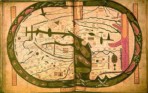 The world map from the Saint-Sever Beatus, dating to c.AD 1050.
 From a 12th-century copy of Etymologiae.
 Map centred on Delos according to Greek tradition, from a French manuscript of Henry of Huntingdon, late 13th century
 Mappa Mundi in La Fleur des Histoires, 1459–1463.
 The Bünting cloverleaf map. A 1581 woodcut, Magdeburg. Jerusalem is in the center, surrounded by Europe, Asia and Africa.
 Unknown, Mer des hystoires world map, 1491, following the model of the T-O map, centered on Jerusalem with East (the biblical location of Paradise) at the top.
 On the left part of the sheet is a zonal or climatic map, communicating geographical information. On the right is a "T-O" map. By Jacobus Philippus Bergomensis.
 T and O map accompanied by a V-in-square map, from a copy of the Etymologiae (c.late 8th century).
 Map from the Saint Gall Isidore manuscript.
 T and O map from the Flemish manuscript of Brunetto Latini, Le Livre dou Tresor, early 14th century.
See also
- Flat Earth, world view
- Globus cruciger
- Mappa mundi, medieval world map
- Babylonian Map of the World
References
- ↑David Woodward, "Medieval Mappaemundi", in The History of Cartography, Vol. 1: Cartography in Prehistoric, Ancient, and Medieval Europe and the Mediterranean, ed. J. B. Harley and David Woodward (Chicago: University of Chicago Press, 1987), 296.
- ↑ للحصول على نظرة عامة على المواقف العلمية المختلفة حول أصول الشكل التخطيطي، انظر كريستوف مونتيل، "مخطط TO ودلالاته الدينية - حالة ظرفية"، في الجغرافيا والمعرفة الدينية في العالم في العصور الوسطى ، تحرير كريستوف مونتيل (برلين: دي جرويتر، 2021)، 60-65.
- ↑ El Escorial, Real Biblioteca, R.II.18, fol. 24v; انظر أيضًا Mauntel, “The TO Diagram and its Religious Connotations”, 61 و Woodward, “Medieval Mappaemundi “, 301.
- ↑ ويليامز 1997 ، ص. 13 : "...the Isidoran tradition, as it was known from peninsular examples, including the earliest of the ubiquitous TO maps. This emblematic figure appears twice at the foot of folio 24v in a copy of Isidore's De Natura Rerum, now Escorial R.II.18. [...] When, in the ninth century, the Escorial manuscript fell into the hands of Eulogius and was supplemented, this precise text (Etymologiae XIV, 2, 3) was placed on the page, folio 25r, facing the primitive map and was introduced another small TO map. To this later TO diagram, however, were added the names of Noah's sons- Shem, Japheth and Ham, for Asia, Europe and Africa, respectively-outside the circle of the globe. This apportionment is only implicit in the Bible (Genesis 9: 18-19). Josephus (dc100 AD) is more explicit as was Hippolytus of Rome, نشر كتابه التاريخي لعام 234، بترجمته اللاتينية، توزيع أبناء نوح في الغرب. مع ذلك، لم يُسلَّط الضوء على توزيع أبناء نوح في كتاب إيسيدور "الأصول"، بل ذُكر عرضًا فقط مع وصف مواقع المدن في الكتاب التاسع. يبدو واضحًا، إذا قبلنا دليل الإسكوريال R.II.18، أن توزيع سام ويافث وحام لم يكن موجودًا في مخطط إيسيدور البدائي. هذا يعني أن استخدام إيسيدور لمخطط TO لم يكن متأثرًا بأي محتوى ديني صريح.
- ↑ إيزيدور الإشبيلي: في طبيعة الأشياء ، ترجمة كالفن ب. كيندال وفايث واليس (ليفربول: مطبعة جامعة ليفربول، 2016)، 175.
- ↑ ترانس. ويليامز 1997 ، ص. 13؛ باترولوجيا لاتينا , المجلد. 83، مجمع. 1016D-1017A: "منطقة كاملة من الأرض تقسم التريفاريام، وتترك نصف أوروبا، وآسيا الأخرى، وثلاثة أفريقيا vocatur. أوروبام تقسم أفريقيا وتقسم الفرس إلى أقصى المحيطات النهاية، وأعمدة هرقل. آسيا أيضًا، وليبيا مع مصر تحدد الفوهة نهر النيلي [...] آسيا أيضًا، ut ait Beatissimus Augustinus، Meridie per Orientem usque ad septentrionem pervenit.
- ↑Isidori Hispalensis episcopi Etymologiarum sive Originvm libri XX, 2 vols, ed. W. M. Lindsay (Oxford: Oxford University Press, 1911), n.p.: "Orbis a rotunditate circuli dictus, quia sicut rota est. [...] Divisus est autem trifarie: e quibus una pars Asia, altera Europa, tertia Africa nuncupatur."
- ↑Stevens, Wesley M. (1980). "The Figure of the Earth in Isidore's 'De natura rerum'". Isis. 71 (2): 268–277. doi:10.1086/352464. JSTOR 230175. S2CID 133430429.
- ↑Woodward, David. "Reality, Symbolism, Time, and Space in Medieval World Maps", Annals of the Association of American Geographers, 1985, p. 517-519.
- 12Michael Livingston, Modern Medieval Map Myths: The Flat World, Ancient Sea-Kings, and DragonsArchived 2006-02-09 at the Wayback Machine, 2002.
- ↑Hiatt, Alfred (2002). "Blank Spaces on the Earth". The Yale Journal of Criticism. 15 (2): 223–250. doi:10.1353/yale.2002.0019. S2CID 145164637.
- ↑Woodward, "Medieval Mappaemundi", 296.
- ↑Mauntel, "The T-O Diagram and its Religious Connotations", 59. A small number of T-O maps instead depict Africa as taking up half the circle as opposed to Asia (Woodward, "Medieval Mappaemundi", 343.) and a smaller number still depict Europe in this way (e.g. Ingrid Baumgärtner, "Die Wahrnehmung Jerusalems auf mittelalterlichen Weltkarten", in Jerusalem: im Hoch- und Spätmittelalter: Konflikte und Konfliktbewältigung - Vorstellungen und Vergegenwärtigungen, ed. Dieter R. Bauer, Klaus Herbers and Nikolas Jaspert (Frankfurt am Main: Campus Verlag, 2001), 271-73).
- ↑ Non-eastern orientations are associated above all with T-O maps that accompany Sallust's Jugurthine War, on which see Woodward, "Medieval Mappaemundi", 343-4, where examples of all four orientations are also provided. There is no consensus on the origins of the predominantly eastern orientation, some like Mauntel, "The T-O Diagram and its Religious Connotations", 65-9 argue that it is a specifically Christian development, while others like Patrick Gautier Dalché, "L'héritage antique de la cartographie médiévale: Les problèmes et les acquis", in Cartography in Antiquity and the Middle Ages: Fresh Perspectives, New Methods, ed. Richard J. A. Talbert and Richard W. Unger (Leiden: Brill, 2008), 55-6 are more circumspect about the specifically Christian significance of this orientation.
- ↑Woodward, "Medieval Mappaemundi", 340 and Baumgärtner, "Die Wahrnehmung Jerusalems", 304.
- ↑ Baumgärtner, "Die Wahrnehmung Jerusalems", 275-94.
- ↑Woodward, "Medieval Mappaemundi", 341-2 and Baumgärtner, "Die Wahrnehmung Jerusalems", 294-310.
- ↑Mauntel, "The T-O Diagram and its Religious Connotations", 67-9.
- ↑Woodward, "Medieval Mappaemundi", 328.
Further reading
- Baumgärtner, Ingrid (2001). "Die Wahrnehmung Jerusalems auf mittelalterlichen Weltkarten". In Dieter R. Bauer, Klaus Herbers and Nikolas Jaspert (eds.), Jerusalem: im Hoch- und Spätmittelalter: Konflikte und Konfliktbewältigung - Vorstellungen und Vergegenwärtigungen, pp. 271-334. Frankfurt am Main: Campus Verlag. ISBN 978-3593368511
- Crosby, Alfred W. (1996). The Measure of Reality: Quantification in Western Europe, 1250-1600. Cambridge: Cambridge University Press. ISBN 0-521-55427-6.
- Englisch, Brigitte (2002). Ordo orbis terrae. Die Weltsicht in den Mappae mundi des frühen und hohen Mittelalters. Berlin: Akademie Verlag. ISBN 3-05-003635-4
- Gautier Dalché, Patrick (2008). "L'héritage antique de la cartographie médiévale: Les problèmes et les acquis", pp. 29-66. In Richard J. A. Talbert and Richard W. Unger (eds.) Cartography in Antiquity and the Middle Ages: Fresh Perspectives, New Methods. Leiden: Brill. ISBN 9789004166639
- Lester, Toby (2009). The fourth part of the world: the race to the ends of the Earth, and the epic story of the map that gave America its name. New York, NY: Free Press. ISBN 9781416535317.
- مونتيل، كريستوف (2023). Die Erdteile in der Weltordnung des Mittelalters. آسيا - أوروبا - أفريقيا (Monographien zur Geschichte des Mittelalters 71) شتوتغارت: هيرسمان. رقم ISBN 978-3-7772-2311-7
- مونتيل، كريستوف (2021). "مخطط TO ودلالاته الدينية - حالة ظرفية"، في كريستوف مونتيل (محرر)، الجغرافيا والمعرفة الدينية في العالم الوسيط، ص 57-82. برلين: دي جرويتر. ISBN 9783110685954
- مود، بي جيه. "تاريخ الأدبيات الأكاديمية لرسم الخرائط الإقناعية" . رسم الخرائط الإقناعية، مجموعة بي جيه مود . مكتبة جامعة كورنيل . تم الاطلاع عليه بتاريخ 22 أكتوبر 2015 .
- ويليامز، جون (1997)، “إيزيدور وأوروسيوس وخريطة بيتوس”، إيماجو موندي ، 49 : 7– 32، دوى : 10.1080/03085699708592856 ، JSTOR 1151330
- وودوارد، ديفيد (1987). " خرائط العالم في العصور الوسطى " (ملف PDF) . في: هارلي، جيه بي؛ وودوارد، ديفيد (محرران). تاريخ رسم الخرائط . المجلد 1: رسم الخرائط في أوروبا ما قبل التاريخ والقديمة والوسيطة والبحر الأبيض المتوسط. شيكاغو: مطبعة جامعة شيكاغو. ISBN 0-226-31633-5.
- زاكاجنيني، كارلو (2012). "خرائط العالم"، في جيوفاني ب. لانفرانشي وآخرون، ليغو! دراسات مقدمة إلى فريدريك ماريو فاليس بمناسبة عيد ميلاده الخامس والستين، الصفحات من 865 إلى 874. فيسبادن، دار هاراسويتز. رقم ISBN 9783447066594
- خرائط القرن السابع
- أنواع الخرائط
- تاريخ رسم الخرائط
- خرائط تاريخية لآسيا
- خرائط تاريخية لأوروبا
- خرائط أفريقيا