
جوجل إيرث
جوجل إيرث هو برنامج حاسوبي وتطبيق ويب من تطوير جوجل ، يُنشئ نموذجًا ثلاثي الأبعاد للأرض بالاعتماد بشكل أساسي على صور الأقمار الصناعية . يرسم البرنامج خريطة للأرض من خلال دمج صور الأقمار الصناعية والصور الجوية وبيانات نظم المعلومات الجغرافية على مجسم ثلاثي الأبعاد للكرة الأرضية، مما يتيح للمستخدمين رؤية المدن والمناظر الطبيعية من زوايا مختلفة. يمكن للمستخدمين استكشاف الكرة الأرضية بإدخال العناوين والإحداثيات، أو باستخدام لوحة المفاتيح أو الفأرة . كما يمكن تحميل البرنامج على الهواتف الذكية أو الأجهزة اللوحية ، واستخدام شاشة اللمس أو القلم للتنقل. يُمكن للمستخدمين إضافة بياناتهم الخاصة باستخدام لغة ترميز Keyhole وتحميلها عبر مصادر متنوعة، مثل المنتديات والمدونات . يُتيح جوجل إيرث عرض أنواع مختلفة من الصور مُدمجة على سطح الأرض، وهو أيضًا عميل لخدمة خرائط الويب . في عام 2019، كشفت جوجل أن جوجل إيرث يُغطي أكثر من 97% من العالم. [ 8 ]
إلى جانب الملاحة الأرضية، يوفر تطبيق جوجل إيرث مجموعة من الأدوات الأخرى، بما في ذلك أداة قياس المسافة. كما تتوفر مجسمات إضافية للقمر والمريخ ، بالإضافة إلى أداة لعرض السماء ليلاً . ويتضمن التطبيق أيضاً لعبة محاكاة طيران . وتتيح ميزات أخرى للمستخدمين عرض صور من أماكن مختلفة تم تحميلها على بانوراميو ، ومعلومات من ويكيبيديا عن بعض المواقع، وصور من خدمة التجوّل الافتراضي. كما تتضمن نسخة جوجل إيرث على الويب ميزة فوياجر، التي تضيف دورياً جولات داخل البرنامج، يقدمها في الغالب علماء ومخرجون وثائقيون.
اعتبر البعض برنامج جوجل إيرث تهديداً للخصوصية والأمن القومي ، مما أدى إلى حظره في العديد من الدول. [ 9 ] وقد طلبت بعض الدول إخفاء مناطق معينة في صور الأقمار الصناعية التي تلتقطها جوجل، وعادةً ما تكون هذه المناطق تضم منشآت عسكرية.
The desktop application was silently abandoned in 2013 with version 7.1, got no updates until 2017 version 7.3 released and Pro became the standard version and was now available for free.[10] Afterwards it got no updates again. As of 2026 the version is still 7.3. In June 2026 Google announced Google Earth Pro will no longer be available for download on 25 June 2027.[11][12]

Background
The core technology behind Google Earth was originally developed at Intrinsic Graphics in the late 1990s. At the time, the company was developing 3D gaming software libraries.[13] As a demo of their 3D software, they created a spinning globe that could be zoomed into, similar to the Powers of Ten film.[13] The demo was popular, but the board of Intrinsic wanted to remain focused on gaming, so in 1999, they created Keyhole Corporation, headed by John Hanke.[13] Keyhole then developed a way to stream large databases of mapping data over the internet to client software, a key part of the technology,[14] and acquired patchworks of mapping data from governments and other sources.[13] The product, called "Keyhole EarthViewer", was sold on CDs for use in fields such as real estate, urban planning, defense, and intelligence; users paid a yearly fee for the service.[14] Despite making several capital deals with Nvidia and Sony,[14] the small company was struggling to pay and retain employees.[13]
Fortunes for the company changed in early 2003 during the 2003 invasion of Iraq, when Dave Lorenzini (Director at Keyhole) enticed CNN, ABC, CBS and other major news networks to use their sophisticated 3D flyby imagery to illustrate Baghdad activities for viewers, in exchange for on-air attribution.[14][13] During the invasion, It was used extensively by Miles O'Brien and other on-air broadcasters, allowing CNN and millions of viewers to follow the progress of the war in a way that had never been seen before.[14][13] Public interest in the software exploded and Keyhole servers were not able to keep up with demand.[14][13] Keyhole was soon contacted by the Central Intelligence Agency's venture capital firm, In-Q-Tel,[15] and the National Geospatial-Intelligence Agency,[16] for use with defense mapping databases, which gave Keyhole a much-needed cash infusion.[13] Intrinsic Graphics was sold in 2003 to Vicarious Visions after its gaming libraries did not sell well, and its core group of engineers and management including Brian McClendon and Michael Jones transitioned to Keyhole with Hanke remaining at the head.[13]
History
Around 2004, Google was finding that over 25% of its searches were of a geospatial character, including searches for maps and directions.[13]
In October 2004, Google acquired Keyhole as part of a strategy to better serve its users.[17] Keyhole's EarthViewer was the foundation for what became Google Earth in 2005 while other aspects of its core technology were integrated into Google Maps.[18]
In 2021, Google replaced its layers feature with a new one on its Google Earth software.[19] This replacement consolidated some layers, but also removed some layers and features.[20]
Google Earth is featured prominently in the 2021 German miniseries The Billion Dollar Code, which serves as a fictionalized account of a 2014 patent infringement lawsuit brought against Google by the German creators of Terravision.[21] The series, which was shown on Netflix, is prefaced by an episode of interviews with the ART+COM developers of Terravision and their legal representative.[22] One of the co-founders of Keyhole has published a first-hand account claiming to debunk the origins, timelines, and interpretations depicted in the fictionalized miniseries.[23] Not shown in the mini-series was that the patent owned by ART+COM and used to challenge Google was completely invalidated after it was shown that another so-called TerraVision, this one at the Stanford Research Institute, predated ART+COM's ideas by several years.[24]
| Version | Release date | Changes |
|---|---|---|
| 1.0 | June 10, 2001 | |
| 1.4 | January 2002 | |
| 1.6 | February 2003 | |
| 1.7.2 | October 2003 |
|
| 2.2 | August 2004 |
|
| 3.0 | June 2005 |
|
| 4.0 | June 2006 | |
| 4.1 | May 2007 | |
| 4.2 | August 2007 |
|
| 4.3 | April 2008 |
|
| 5.0 | May 2009 |
|
| 5.1 | November 2009 | |
| 5.2 | July 2010 |
|
| 6.0 | March 2011 |
|
| 6.1 | October 2011 | |
| 6.2 | April 2012 |
|
| 7.0 | December 2012 |
|
| 7.1 | April 2013 |
|
| 7.3 | July 2017 |
|
| 8.0 | October 2014 |
|
| 9.0 | April 2017 | |
| 10.0 | September 2023 |
|
Imagery
Google Earth's imagery is displayed on a digital globe, which displays the planet's surface using a single composited image from a far distance. After zooming in far enough, the imagery transitions into different imagery of the same area with finer detail, which varies in date and time from one area to the next. The imagery is retrieved from satellites or aircraft.[30] Before the launch of NASA and the USGS'sLandsat 8 satellite, Google relied partially on imagery from Landsat 7, which suffered from a hardware malfunction that left diagonal gaps in images.[31] In 2013, Google used datamining to remedy the issue, providing what was described as a successor to the Blue Marble image of Earth, with a single large image of the entire planet. This was achieved by combining multiple sets of imagery taken from Landsat 7 to eliminate clouds and diagonal gaps, creating a single "mosaic" image.[32] Google has since used myriad sources to provide imagery in a higher quality and with greater frequency.[33] Imagery is hosted on Google's servers, which are contacted by the application when opened, requiring an Internet connection.
Imagery resolution ranges from 0.15 to 15 meters (0.49 to 49.21 ft) except for the ocean floor, which ranges from 100 to 1,000 meters (330 to 3,280 ft).[34] For much of the Earth, Google Earth uses digital elevation model data collected by NASA's Shuttle Radar Topography Mission.[35] This creates the impression of three-dimensional terrain, even where the imagery is only two-dimensional.
Google asserts that every image created from Google Earth using satellite data provided by Google Earth is a copyrighted map. Any derivative from Google Earth is made from data that Google claims copyright under United States Copyright Law. Google grants license to this data allowing, among other things, non-commercial personal use of the images (e.g., on a personal website or blog) as long as copyrights and attributions are preserved.[36] By contrast, images created with NASA's globe software WorldWind use The Blue Marble, Landsat, or USGS imagery, each of which is in the public domain.
In version 5.0, Google introduced Historical Imagery, allowing users to view earlier imagery. Clicking the clock icon in the toolbar opens a time slider, which marks the time of available imagery from the past. This feature allows for observation of an area's changes over time.[37] Utilizing the timelapse feature allows for the ability to view a zoom-able video as far back as 38 years.[38]
3D imagery


Google Earth shows 3Dbuilding models in some cities, including photorealistic 3D imagery made using photogrammetry.[39] The first 3D buildings in Google Earth were created using 3D modeling applications such as SketchUp and, beginning in 2009, Building Maker,[40] and were uploaded to Google Earth via the 3D Warehouse. In June 2012, Google announced that it would be replacing user-generated 3D buildings with an auto-generated 3D mesh.[41] This would be phased in, starting with select larger cities, with the notable exception of cities such as London and Toronto which required more time to process detailed imagery of their vast number of buildings. The reason given is to have greater uniformity in 3D buildings and to compete with Nokia Here and Apple Maps, which were already using this technology. The coverage began that year in 21 cities in four countries.[42] By early 2016, 3D imagery had been expanded to hundreds of cities in over 40 countries, including every U.S. state and encompassing every continent except Antarctica.
In 2009, in a collaboration between Google and the Museo del Prado in Madrid, the museum selected 14 of its paintings to be photographed and displayed at the resolution of 14,000 megapixels inside the 3D version of the Prado in Google Earth and Google Maps.[43][44]
Street View
On April 15, 2008, with version 4.3, Google fully integrated Street View into Google Earth.[45] Street View displays 360° panoramic street-level photos of select cities and their surroundings. The photos were taken by cameras mounted on automobiles, can be viewed at different scales and from many angles, and are navigable by arrow icons imposed on them.
Using Street View on Google Earth, users can visit and explore 30 UNESCO World Heritage Sites with historical context and pins for each. The sites include the Great Pyramid, the Taj Mahal, Sagrada Família, the Dolomites, the Royal Botanic Gardens, Kew, and the Great Sphinx.[46]
In 2019, Walt Disney World and Pixar partnered with Google to create Pixar Street View. An activation that enabled viewers to search for hidden Pixar Easter eggs inside Toy Story Land at Disney's Hollywood Studios through street view.[47]
Water and ocean
Introduced in Google Earth 5.0 in 2009, the Google Ocean feature allows users to zoom below the surface of the ocean and view the 3D bathymetry. Supporting over 20 content layers, it contains information from leading scientists and oceanographers.[48] On April 14, 2009, Google added bathymetric data for the Great Lakes.[49][50]
In June 2011, Google increased the resolution of some deep ocean floor areas from 1-kilometer grids to 100 meters.[34] The high-resolution features were developed by oceanographers at Columbia University's Lamont–Doherty Earth Observatory from scientific data collected on research cruises. The sharper focus is available for about 5 percent of the oceans. This can be seen in the Hudson off New York City, the Wini Seamount near Hawaii, and the Mendocino Ridge off the U.S. Pacific coast.[51]
Outer space
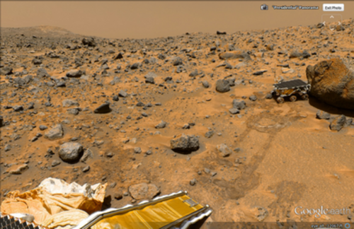
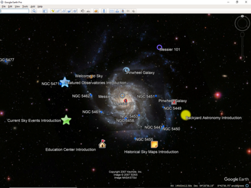

Google has programs and features, including within Google Earth, allowing exploration of Mars, the Moon, the view of the sky from Earth and outer space, including the surfaces of various objects in the Solar System.
Google Sky
Google Sky is a feature that was introduced in Google Earth 4.2 on August 22, 2007, in a browser-based application on March 13, 2008,[52] and to Androidsmartphones, with augmented reality features. Google Sky allows users to view stars and other celestial bodies.[53] It was produced by Google through a partnership with the Space Telescope Science Institute (STScI) in Baltimore, the science operations center for the Hubble Space Telescope. Alberto Conti and his co-developer Carol Christian of STScI planned to add the public images from 2007,[54] as well as color images of all of the archived data from Hubble's Advanced Camera for Surveys. Then-newly released Hubble pictures were added to the Google Sky program as soon as they were issued.
New features such as multi-wavelength data, positions of major satellites and their orbits as well as educational resources are provided to the Google Earth community and also through Christian and Conti's website for Sky.[55] Also visible on Sky mode are constellations, stars, galaxies, and animations depicting the planets in their orbits. A real-time Google Sky mashup of recent astronomical transients, using the VOEvent protocol, is provided by the VOEventNet collaboration.[56] Other programs similar to Google Sky include Microsoft WorldWide Telescope and Stellarium.
Google Mars
Google Mars is an application within Google Earth that is a version of the program for imagery of the planet Mars. Google also operates a browser-based version, although the maps are of a much higher resolution within Google Earth, and include 3D terrain, as well as infrared imagery and elevation data. There are also some extremely high-resolution images from the Mars Reconnaissance Orbiter's HiRISE camera that are of a similar resolution to those of the cities on Earth. Finally, there are many high-resolution panoramic images from various Mars landers, such as the Mars Exploration Rovers, Spirit and Opportunity, that can be viewed in a similar way to Google Street View.
يحتوي تطبيق Mars أيضًا على تطبيق صغير موجود بالقرب من وجه Mars . يُطلق عليه اسم Meliza، وهو عبارة عن شخصية روبوتية يمكن للمستخدم التحدث معها. [ 57 ]
جوجل مون
كان تطبيق Google Moon في الأصل تطبيقًا للمتصفح، وهو عبارة عن ميزة تتيح استكشاف القمر. أضافت جوجل هذه الميزة إلى Google Earth بمناسبة الذكرى الأربعين لمهمة أبولو 11 في 20 يوليو 2009. [ 58 ] وقد أعلنت جوجل عن هذه الميزة وعرضتها على مجموعة من الضيوف المدعوين برفقة باز ألدرين في متحف نيوزيوم في واشنطن العاصمة. [ 59 ] [ 60 ] يتضمن Google Moon جولات متعددة، بما في ذلك جولة خاصة بمهام أبولو ، تتضمن خرائط وفيديوهات وصور بانورامية على غرار خدمة التجوّل الافتراضي، وكلها مقدمة من وكالة ناسا .
ميزات أخرى
يحتوي برنامج جوجل إيرث على العديد من الميزات التي تُمكّن المستخدم من التعرّف على أماكن مُحدّدة. تُسمى هذه الميزات "الطبقات"، وتشمل أنواعًا مختلفة من الوسائط، بما في ذلك الصور والفيديوهات. تتضمن بعض الطبقات جولات افتراضية تُوجّه المستخدم بين أماكن مُحدّدة بترتيب مُعيّن. تُنشأ الطبقات باستخدام لغة ترميز Keyhole (KML)، والتي يُمكن للمستخدمين استخدامها أيضًا لإنشاء طبقات مُخصّصة. [ 61 ] يُمكن تمييز المواقع بعلامات مكانية وتنظيمها في مجلدات؛ على سبيل المثال، يُمكن للمستخدم استخدام العلامات المكانية لسرد المعالم البارزة حول العالم، ثم إضافة وصف لها مع صور وفيديوهات، والتي يُمكن عرضها بالنقر على العلامات المكانية أثناء عرض الطبقة الجديدة في التطبيق.
في ديسمبر 2006، أضافت جوجل إيرث تكاملاً جديداً مع ويكيبيديا وبانوراميو . بالنسبة لطبقة ويكيبيديا، تُستخرج الإحداثيات من المدخلات عبر قوالب Coord . كما توجد طبقة مجتمعية من مشروع ويكيبيديا العالمية . تستخدم هذه الطبقة إحداثيات أكثر، وأنواعاً مختلفة من العرض، وتدعم لغاتٍ أكثر من طبقة ويكيبيديا المدمجة. [ 62 ] [ 63 ] تعرض طبقة بانوراميو صوراً حمّلها مستخدمو بانوراميو، وتُضاف إلى جوجل إيرث بناءً على بيانات الموقع التي يُدخلها المستخدم. بالإضافة إلى الصور الثابتة، تتضمن جوجل إيرث أيضاً طبقةً للصور البانورامية التي يُرسلها المستخدمون، ويمكن تصفحها بطريقة مشابهة لتصفح الشوارع.
يتضمن برنامج جوجل إيرث العديد من الميزات التي تتيح للمستخدم متابعة الأحداث الجارية. في عام 2007، بدأت جوجل في تزويد المستخدمين بإمكانية مراقبة بيانات حركة المرور التي يوفرها جوجل ترافيك في الوقت الفعلي، استنادًا إلى معلومات يتم جمعها من مواقع مستخدمي الهواتف المحمولة المحددة بواسطة نظام تحديد المواقع العالمي (GPS). [ 64 ]
أجهزة محاكاة الطيران
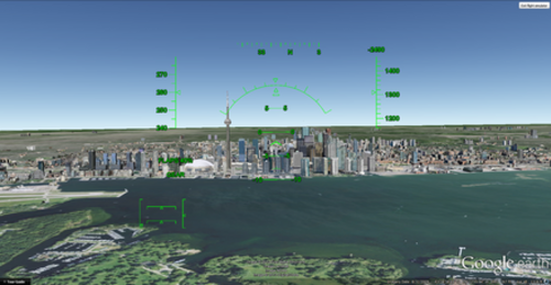
في الإصدار 4.2 من برنامج جوجل إيرث، أُضيفت ميزة محاكاة الطيران إلى التطبيق. كانت هذه الميزة مخفية عند إطلاقها عام 2007، ولكن بدءًا من الإصدار 4.3، أصبحت خيارًا مُحددًا في القائمة. بالإضافة إلى التحكم عبر لوحة المفاتيح، يُمكن التحكم في المحاكاة باستخدام الفأرة أو عصا التحكم. [ 65 ] [ 66 ] كما تدعم المحاكاة الرسوم المتحركة، مما يسمح بتحريك عناصر مثل الطائرات أثناء المحاكاة. [ 67 ]
تم إنشاء برنامج محاكاة طيران آخر، GeoFS، تحت اسم GEFS-Online باستخدام واجهة برمجة تطبيقات Google Earth Plug-in للعمل ضمن متصفح الويب . اعتبارًا من 1 سبتمبر 2015، يستخدم البرنامج الآن برنامج CesiumJS مفتوح المصدر نظرًا لتوقف دعم Google Earth Plug-in. [ 68 ]
ليكويد جالاكسي
ليكويد جالاكسي عبارة عن مجموعة من أجهزة الكمبيوتر التي تشغل برنامج جوجل إيرث، مما يوفر تجربة غامرة . في 30 سبتمبر 2010، نشرت جوجل بيانات التكوين والمخططات الخاصة بأجهزتها، [ 69 ] ووضعت التعليمات البرمجية وأدلة الإعداد على ويكي ليكويد جالاكسي. [ 70 ] كما استُخدم ليكويد جالاكسي كعارض صور بانورامية باستخدام KRpano، بالإضافة إلى استخدامه كعارض لخرائط جوجل ستريت فيو باستخدام Peruse-a-Rue. [ 71 ] Peruse-a-Rue هي طريقة لمزامنة عملاء واجهة برمجة تطبيقات الخرائط المتعددة . [ 72 ]
المتغيرات
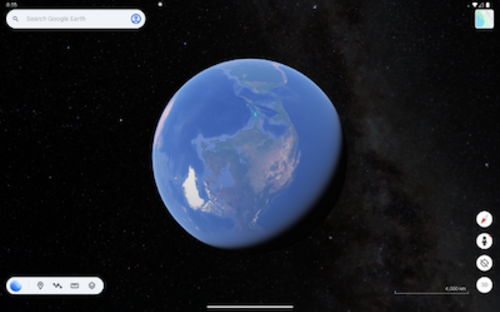
Google Earth has been released on macOS, Linux, iOS, and Android. The Linux version began with the version 4 beta of Google Earth, as a native port using the Qt toolkit. The Free Software Foundation considers the development of a free compatible client for Google Earth to be a High Priority Free Software Project.[73] Google Earth was released for Android on February 22, 2010,[74] and on iOS on October 27, 2008.[75][76] The mobile versions of Google Earth can make use of multi-touch interfaces to move on the globe, zoom or rotate the view, and allow to select the current location. An automotive version of Google Earth was made available in the 2010 Audi A8.[77] On February 27, 2020, Google opened up its web-based version of Earth to browsers like Firefox, Edge, and Opera.[78][79]
Google Earth Pro
Google Earth Pro was originally the business-oriented upgrade to Google Earth, with features such as a movie maker and data importer. Up until late January 2015, it was available for $399/year, Or £399/year in the uk, though Google decided to make it free to the public.[80][81] Google Earth Pro is currently the standard version of the Google Earth desktop application as of version 7.3.[82] The Pro version includes add-on software for movie making, advanced printing, and precise measurements, and is available for Windows, macOS, and Linux.[83]
Google Earth Plus
Discontinued in December 2008, Google Earth Plus was a paid subscription upgrade to Google Earth that provided customers with the following features, most of which have become available in the free Google Earth.[84] One such feature was GPS integration, which allowed users to read tracks and waypoints from a GPS device. A variety of third-party applications have been created which provide this functionality using the basic version of Google Earth by generating KML or KMZ files based on user-specified or user-recorded waypoints.
Google Earth Enterprise
صُمم برنامج Google Earth Enterprise للاستخدام من قِبل المؤسسات التي يُمكنها الاستفادة من إمكانيات البرنامج، على سبيل المثال من خلال إنشاء مجسم كروي ثلاثي الأبعاد يحتوي على بيانات الشركة، ومتاح لجميع موظفيها. [ 85 ] في 20 مارس 2015، أوقفت جوجل دعم منتج Google Earth Enterprise، وانتهى الدعم في 22 مارس 2017. [ 86 ] كان Google Earth Enterprise يُتيح للمطورين إنشاء خرائط ومجسمات كروية ثلاثية الأبعاد للاستخدام الشخصي، واستضافتها عبر المنصة. نُشرت شفرة المصدر لبرامج GEE Fusion وGEE Server وGEE Portable Server على منصة GitHub بموجب ترخيص Apache2 في مارس 2017. [ 87 ]
جوجل إيرث ستوديو
يُعدّ Google Earth Studio نسخةً إلكترونيةً من Google Earth تُستخدم لإنشاء الرسوم المتحركة باستخدام صور Google Earth ثلاثية الأبعاد. اعتبارًا من يونيو 2021، كان البرنامج متاحًا للمعاينة فقط ويتطلب التسجيل لاستخدامه. [ 88 ] يتميز البرنامج برسوم متحركة باستخدام الإطارات الرئيسية، وإعدادات مسبقة تُسمى "مشاريع البدء السريع"، وإمكانية تصدير الصور من الكاميرا ثلاثية الأبعاد. [ 89 ]
جوجل إيرث 9
يُعدّ Google Earth 9 إصدارًا من Google Earth، أُطلق لأول مرة في 18 أبريل 2017، بعد عامين من التطوير. [ 90 ] تمثّلت الميزة الرئيسية لهذا الإصدار في إطلاق نسخة ويب جديدة من Google Earth. [ 91 ] أضاف هذا الإصدار ميزة "Voyager"، التي تُمكّن المستخدمين من استعراض صفحة بوابة تحتوي على جولات إرشادية يقودها علماء ومخرجون وثائقيون. [ 92 ] كما أضاف الإصدار زر "أشعر أنني محظوظ"، المُمثّل برمز النرد، والذي ينقل المستخدم إلى موقع عشوائي على سطح الأرض، بالإضافة إلى عرض "بطاقة معلومات" تحتوي على مقتطف قصير من مقالة ويكيبيديا الخاصة بالموقع. [ 92 ]
إضافة جوجل إيرث
كانت واجهة برمجة تطبيقات جوجل إيرث (Google Earth API) خدمة تجريبية مجانية، تتيح للمستخدمين دمج نسخة من جوجل إيرث في صفحات الويب. وقد مكّنت هذه الواجهة من إنشاء تطبيقات خرائط ثلاثية الأبعاد متطورة. [ 93 ] عند الكشف عنها في مؤتمر جوجل للمطورين I/O عام 2008، عرضت الشركة تطبيقات محتملة، مثل لعبة يتحكم فيها اللاعب بشاحنة نقل حليب فوق سطح جوجل إيرث. [ 94 ] تم إيقاف دعم واجهة برمجة تطبيقات جوجل إيرث اعتبارًا من 15 ديسمبر 2014، واستمر الدعم حتى 15 ديسمبر 2015. [ 95 ] أنهى جوجل كروم دعمه لواجهة برمجة تطبيقات نتسكيب الإضافية (التي تعتمد عليها واجهة برمجة تطبيقات جوجل إيرث) بنهاية عام 2016. [ 96 ]
جوجل إيرث الواقع الافتراضي
On November 16, 2016, Google released a virtual reality version of Google Earth for Valve's Steam computer gaming platform.[97][98] Google Earth VR allows users to navigate using VR controllers, and is currently compatible with the Oculus Rift and HTC Vivevirtual reality headsets. On September 14, 2017, as part of Google Earth VR's 1.4 update, Google added Street View support.[99]
Google Earth Engine

Google Earth Engine is a cloud computing platform for processing satellite imagery and other geospatial and observation data. It provides access to a large database of satellite imagery and the computational power needed to analyze those images.[100] Google Earth Engine allows observation of dynamic changes in agriculture, natural resources, and climate using geospatial data from the Landsat satellite program, which passes over the same places on the Earth every sixteen days.[101][102] Google Earth Engine has become a platform that makes Landsat and Sentinel-2 data easily accessible to researchers in collaboration with the Google Cloud Storage.[101] Google Earth Engine provides a data catalog along with computers for analysis; this allows scientists to collaborate using data, algorithms, and visualizations.[103] The platform provides Python and JavaScript application programming interfaces for making requests to the servers,[104] and includes a graphical user interface[105] for developing applications.
An early prototype of Earth Engine, based on the Carnegie Institute for Science's CLASlite system and Imazon's Sistema de Alerta de Desmatamento (SAD) was demonstrated in 2009[106] at COP15, and Earth Engine was officially launched in 2010[107] at COP16, along with maps of the water in the Congo Basin and forests in Mexico produced by researchers using the tool.
In 2013, researchers from University of Maryland produced the first high-resolution global forest cover and loss maps using Earth Engine, reporting an overall loss in global forest cover.[108] Other early applications using Earth Engine spanned a diverse variety of topics, including: Tiger Habitat Monitoring,[109] Malaria Risk Mapping,[110] Global Surface Water,[111] increases in vegetation around Mount Everest,[112] and the annual Forest Landscape Integrity Index.[113] Since then, Earth Engine has been used in the production of hundreds of scientific journal articles[114] in many fields including: forestry and agriculture, hydrology, water quality monitoring and assessment,[115] natural disaster monitoring and assessment, urban mapping, atmospheric and climate sciences and soil mapping.[114]
Earth Engine has been free for academic and research purposes since its launch, but commercial use was prohibited until 2021, when Google announced a preview of Earth Engine as a commercial cloud offering, with Unilever, USDA, and Climate Engine among the early adopters.[116]
Controversy and criticism
The software has been criticized by a number of special interest groups, including national officials, as being an invasion of privacy or posing a threat to national security. The typical argument is that the software provides information about military or other critical installations that could be used by terrorists. Google Earth has been blocked by Google in Iran[117] and Sudan[118] since 2007, due to United States government export restrictions. The program has also been blocked in Morocco since 2006 by Maroc Telecom, a major service provider in the country.[119]
In the academic realm, increasing attention has been devoted to both Google Earth and its place in the development of digital globes. In particular, the International Journal of Digital Earth features multiple articles evaluating and comparing the development of Google Earth and its differences when compared to other professional, scientific, and governmental platforms.[120] Google Earth's role in the expansion of "Earth observing media" has been examined to understand how it is shaping a shared cultural consciousness regarding climate change and humanity's capacity to treat the Earth as an engineerable object.[121]
Defense
- In 2006, one user spotted a large topographical replica in a remote region of China. The model is a small-scale (1/500) version of the Karakoram Mountain Range, which is under the control of China but claimed by India. When later confirmed as a replica of this region, spectators began entertaining military implications.[122][123]
- In July 2007, it was reported that a new Chinese NavyJin-classnuclearballistic missilesubmarine was photographed at the Xiaopingdao Submarine Base south of Dalian.[124]
- Hamas and the al-Aqsa Martyrs' Brigades have reportedly used Google Earth to plan Qassam rocket attacks on Israel from Gaza. (See: Palestinian rocket attacks on Israel)[125][126]
- On February 13, 2019, 3D imagery was launched in four of Taiwan's cities: Taipei, New Taipei, Taoyuan, and Taichung. This has caused concerns from Taiwanese officials, such as Taiwan's Defense MinisterYen Teh-fa, saying that the 3D imagery exposed some of its Patriot missile sites. Ten days later on February 23, Google confirmed that it would be removing all of its 3D imagery from Taiwan.[127][128][129]
National security
- Former president of IndiaA. P. J. Abdul Kalam expressed concern over the availability of high-resolution pictures of sensitive locations in India.[130] Google subsequently agreed to censor such sites.[131]
- أعلنت منظمة أبحاث الفضاء الهندية أن برنامج جوجل إيرث يشكل تهديداً أمنياً للهند، وتسعى إلى الحوار مع مسؤولي جوجل. [ 132 ]
- أعربت حكومة كوريا الجنوبية عن قلقها من أن البرنامج يوفر صوراً للقصر الرئاسي ومنشآت عسكرية مختلفة يمكن أن تستخدمها جارتها المعادية كوريا الشمالية . [ 133 ]
- في عام 2006، بدأ برنامج جوجل إيرث بتقديم صور تفصيلية لمناطق سرية في إسرائيل. أظهرت الصور قواعد جيش الدفاع الإسرائيلي ، بما في ذلك منشآت سرية تابعة لسلاح الجو الإسرائيلي ، ونظام الدفاع الصاروخي الإسرائيلي "آرو "، والمقر العسكري ومجمع وزارة الدفاع في تل أبيب ، ومحطة طاقة بالغة السرية بالقرب من عسقلان ، ومركز النقب للأبحاث النووية . كما أظهرت الصور المقر المزعوم للموساد ، جهاز المخابرات الخارجية الإسرائيلي، والذي يُصنف موقعه ضمن المعلومات السرية للغاية. [ 134 ]
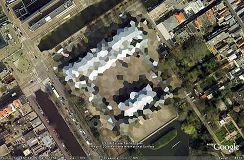
- نتيجةً لضغوط من حكومة الولايات المتحدة ، تم إخفاء مقر إقامة نائب الرئيس في ميدان المرصد رقم واحد بتقنية البكسلة في خرائط جوجل وجوجل إيرث عام ٢٠٠٦، ولكن تم رفع هذا القيد لاحقًا. وتُعدّ جدوى هذا التخفيض في الدقة موضع شك، إذ تتوفر صور عالية الدقة ومسح جوي للموقع بسهولة على الإنترنت. [ ١٣٥ ] كما تم إخفاء مبنى الكابيتول هيل بهذه الطريقة سابقًا. وكذلك الإسطبلات الملكية في لاهاي بهولندا، وينطبق الأمر نفسه على المطارات في اليونان.
- اعترف المسلح الوحيد الناجي من هجمات مومباي عام 2008 باستخدام برنامج جوجل إيرث للتعرف على مواقع المباني المستخدمة في الهجمات. [ 136 ]
- استخدم مايكل فينتون ، المعروف أيضًا باسم طالب إسلام، برنامج جوجل إيرث في التخطيط لمحاولته تفجير مبنى بول فيندلي الفيدرالي والمكاتب المجاورة للنائب آرون شوك في سبرينغفيلد، إلينوي ، في 24 سبتمبر 2009. [ 137 ]
مخاوف أخرى
- طلب مشغلو مفاعل لوكاس هايتس النووي في سيدني ، نيو ساوث ويلز ، أستراليا، من جوجل حجب الصور عالية الدقة للمنشأة. [ 138 ] ثم سحبوا الطلب لاحقاً. [ 139 ]
- In 2009, Google superimposed old woodblock prints of maps from 18th- and 19th-century Japan over Japan today. These maps marked areas inhabited by the burakumin caste, formerly known as eta (穢多), literally "abundance of defilement", who were considered "non-humans" for their "dirty" occupations, including leather tanning and butchery. Descendants of members of the burakumin caste still face discrimination today and many Japanese people feared that some would use these areas, labeled etamura (穢多村 "eta village"), to target current inhabitants of them. These maps are still visible on Google Earth, but with the label removed where necessary.[140]
- Late 2000s versions of Google Earth require a software component running in the background that will automatically download and install updates. Several users expressed concerns that there is not an easy way to disable this updater, as it runs without the permission of the user.[141]
- In February 2014, the Berlin-based ART+COM charged that Google Earth products infringe U.S. Patent No. RE44,550, entitled "Method and Device for Pictorial Representation of Space-related Data" and had remarkable similarity to Terravision which was developed by ART+COM in 1993 and patented in 1995.[142] The court decided against Art+Com both at trial[143] and on appeal[144] because trial testimony showed that Art+Com was aware of an existing, substantially similar invention that it failed to mention as "prior art" in its patent application, thereby invalidating their patent. Stephen Lau, a former employee of federally funded, not-for-profit Stanford Research Institute ("SRI") testified that he helped develop SRI Terravision, an earth visualization application, and that he wrote 89% of the code. He further testified that he shared and discussed SRI Terravision code with Art+Com. Both systems used a multi-resolution pyramid of imagery to let users zoom from high to low altitudes, and both were called Terravision. Art+Com agreed to rename their product because SRI's came first. Stephen Lau died from COVID-19 in March 2020.[145]
See also
- Elevation
- Esri, publisher of ArcGIS Earth
- Flyover (Apple Maps), similar 3D feature on Apple Maps
- List of space flight simulation games
- Planetarium software
- List of observatory software
- Orthophotomap, the type of aerial and satellite imagery present in Google Earth
- Virtual globe, the category of software that includes Google Earth
- Web mapping
References
- ↑"See notes on Google Earth releases". Google Support. Retrieved June 1, 2026.
- ↑"PPA: Google Earth". UbuntuUpdates. Retrieved June 1, 2026.
- ↑"Google Earth". Google Play.
- ↑"Google Earth 10.109.82.04". APKMirror.
- ↑"Google Earth". App Store.
- ↑"Google Earth Web". Google Earth.
- ↑"Install & uninstall Google Earth Pro". Google Earth Help. Archived from the original on January 11, 2023. Retrieved January 11, 2023.
- ↑"Google reveals just how much of the world it's mapped with Street View and Earth". www.theverge.com. December 13, 2019. Archived from the original on May 25, 2022. Retrieved December 18, 2021.
- ↑"US general claims Google Earth is a risk to security". IT PRO. June 22, 2007. Archived from the original on July 16, 2022. Retrieved July 16, 2022.
- ↑Schwartz, Barry (July 11, 2017). "Google Releases Google Earth Pro: Google Earth Free To Upgrade". Search Engine Roundtable. Retrieved July 13, 2026.
- ↑Eriksson, Viktor (July 8, 2026). "You have until 2027 to download Google Earth Pro. Do it now". PCWorld. Retrieved July 13, 2026.
- ↑Blake, Alex (July 8, 2026). "Google Earth Pro for desktop is being discontinued, and users are furious". www.msn.com. Retrieved July 13, 2026.
- 1234567891011Kilday, Bill (2018). Never Lost Again: The Google Mapping Revolution That Sparked New Industries and Augmented Our Reality. Harper Business. ISBN 978-0-06-267304-6.
- ١ ٢ ٣ ٤ ٥ ٦ كيفن ماني (٢١ مارس ٢٠٠٣). "شركة تقنية صغيرة تُبهر المشاهدين" . يو إس إيه توداي . مؤرشف من الأصل في ١٣ سبتمبر ٢٠١٢. تم الاطلاع عليه في ٢٩ أغسطس ٢٠١٧ .
- ↑ "تعرّف على مستثمر رأس المال المخاطر في وكالة المخابرات المركزية" . بلومبيرغ بيزنس ويك . مؤرشف من الأصل في 5 يونيو 2013.
- ↑ "رسائل بريد إلكتروني من أوكلاند تكشف لمحة أخرى عن مجمع جوجل-الجيش-المراقبة" . باندا ديلي . 7 مارس 2014. مؤرشف من الأصل في 8 مايو 2016. تم الاطلاع عليه في 14 أغسطس 2017 .
- ↑ "جوجل تستحوذ على كي هول" . صحيفة وول ستريت جورنال . 27 أكتوبر 2004. مؤرشف من الأصل في 4 ديسمبر 2017. تم الاطلاع عليه في 3 ديسمبر 2017 .
- ↑ أورلوفسكي، أندرو (28 أكتوبر/تشرين الأول 2004). "جوجل تستحوذ على شركة ناشئة لرسم الخرائط مدعومة من وكالة المخابرات المركزية" . ذا ريجستر . مؤرشف من الأصل في 11 فبراير/شباط 2017. تم الاطلاع عليه في 27 أبريل/نيسان 2017 .
- ↑ فريق العمل (20 يوليو 2021). "طبقات جديدة مُضافة في Google Earth Pro!" . مساعدة Google Earth . مؤرشف من الأصل في 9 نوفمبر 2021. تم الاطلاع عليه في 9 نوفمبر 2011 .
- ↑ "حدود المقاطعات ومعلومات أخرى مفقودة من طبقة الحدود والتسميات الجديدة" . مساعدة جوجل إيرث . 4 سبتمبر 2021. مؤرشف من الأصل في 9 نوفمبر 2021. تم الاطلاع عليه في 9 نوفمبر 2021 .
- ↑ ""شفرة المليار دولار: المعركة على جوجل إيرث" . دويتشه فيله . 7 أكتوبر 2021. مؤرشف من الأصل في 11 أكتوبر 2021. تم الاطلاع عليه في 11 أكتوبر 2021 .
- ↑ "شفرة المليار دولار" . Netflix.com . نتفليكس. مؤرشف من الأصل في 18 ديسمبر 2023. تم الاطلاع عليه في 22 أكتوبر 2021 .
- ↑ بار زئيف، آفي (14 أكتوبر 2021). "هل سُرقت خدمة جوجل إيرث؟" . ميديوم . مؤرشف من الأصل في 17 أكتوبر 2021. تم الاطلاع عليه في 17 أكتوبر 2021 .
- ↑"CAFC affirms invalidity of geographic map visualization patent asserted against Google Earth". IPWatchdog.com | Patents & Intellectual Property Law. October 25, 2017. Archived from the original on November 14, 2023. Retrieved October 23, 2023.
- ↑"Update Google Earth Pro". Archived from the original on March 18, 2018. Retrieved April 23, 2018.
- ↑"Google Earth 8.0 Hits Google Play, New 3D Rendering Tech and Refreshed Maps in Tow". October 22, 2014. Archived from the original on October 15, 2023. Retrieved October 3, 2023.
- ↑Shah, Gopal (April 18, 2017). "Welcome home to the new Google Earth". The Keyword - Google Product and Technology News and Stories. Google. Archived from the original on November 14, 2023. Retrieved November 14, 2023.
- ↑Broussard, Mitchel (August 2, 2017). "Google Earth iOS App Updated With Flyover-Like 3D Views and 64-Bit Support". MacRumors. Archived from the original on December 18, 2023. Retrieved November 14, 2023.
- ↑Schoon, Ben (September 23, 2023). "Google Earth gets a redesigned Android app with Projects support, removes Voyager". 9to5Google. Archived from the original on September 27, 2023. Retrieved November 10, 2023.
- ↑"How images are collected". Archived from the original on September 19, 2017. Retrieved August 6, 2017.
- ↑"SLC-off Products: Background". United States Geological Survey. Archived from the original on August 7, 2017. Retrieved August 6, 2017.
- ↑"Only clear skies on Google Maps and Earth". June 26, 2013. Archived from the original on August 7, 2017. Retrieved August 6, 2017.
- ↑"Google Earth and Maps get sharper satellite imagery with new update". Tech Crunch. June 27, 2016. Archived from the original on August 7, 2017. Retrieved August 6, 2017.
- 12"New Google Ocean Maps Dive Deep". The Earth Institute – Columbia University. June 8, 2011. Archived from the original on April 5, 2012. Retrieved July 30, 2012.
- ↑Farr, Tom G.; Rosen, Paul A.; Caro, Edward; Crippen, Robert; Duren, Riley; Hensley, Scott; Kobrick, Michael; Paller, Mimi; Rodriguez, Ernesto; Roth, Ladislav; Seal, David; Shaffer, Scott; Shimada, Joanne; Umland, Jeffrey; Werner, Marian; Oskin, Michael; Burbank, Douglas; Alsdorf, Douglas (2007). "The Shuttle Radar Topography Mission". Reviews of Geophysics. 45 (2): RG2004. Bibcode:2007RvGeo..45.2004F. CiteSeerX 10.1.1.102.9372. doi:10.1029/2005RG000183. ISSN 1944-9208. S2CID 140735782.
- ↑"Can I post images to the web?". Google Earth Help Center. Archived from the original on September 27, 2011. Retrieved January 20, 2007.
- ↑"Dive into New Google Earth". Archived from the original on February 3, 2009. Retrieved February 3, 2009.
- ↑"Timelapse." Google Earth Engine, earthengine.google.com/timelapse/.
- ↑Gopal Shah, Google Earth's Incredible 3D Imagery, ExplainedArchived June 11, 2020, at the Wayback Machine, April 18, 2017
- ↑"Introducing Google Building Maker". Archived from the original on August 19, 2016. Retrieved July 24, 2016.
- ↑"Explore the world with tour guide and 3D imagery in Google Earth 7". Google LatLong Blog. Archived from the original on January 28, 2016. Retrieved July 24, 2016.
- ↑"Google Earth adds new 3D imagery in 21 cities to its 11,000 guided tours of our planet". November 2012. Archived from the original on February 21, 2019. Retrieved July 24, 2016.
- ↑Giles Tremlett (January 14, 2009). "Online gallery zooms in on Prado's masterpieces (even the smutty bits)". The Guardian. London. Archived from the original on February 2, 2017. Retrieved December 11, 2016.
- ↑"14 masterpieces from the Museo del Prado in mega-high resolution on Google Earth". Museo del Prado. January 14, 2009. Archived from the original on December 4, 2017. Retrieved December 3, 2017.
- ↑Hoffman, Tony (May 6, 2008). "Google Earth 4.3". PC Magazine. Archived from the original on February 21, 2019. Retrieved January 1, 2018.
- ↑"Check out 30 famous World Heritage sites you can virtually visit on Google Earth while social distancing". Business Insider. Archived from the original on March 21, 2020. Retrieved March 22, 2020.
- ↑"Pixar Easter Eggs Hidden in Google Street View Imagery of Toy Story Land at Disney's Hollywood Studios". Disney Parks Blog. July 5, 2019. Archived from the original on November 5, 2020. Retrieved October 9, 2020.
- ↑"Google Earth dives under the sea". BBC News. February 2, 2009. Archived from the original on March 10, 2012. Retrieved May 3, 2010.
- ↑"Google Earth now includes US "Third Coast"". Google Lat Long. Archived from the original on January 11, 2016. Retrieved December 10, 2020.
- ↑"New View of Ocean Floor in Google Earth". Gearthblog.com. January 18, 2009. Archived from the original on August 3, 2017. Retrieved August 25, 2010.
- ↑"Google Lat Long: See the seafloor like never before on World Oceans Day". Google-latlong.blogspot.com. June 8, 2011. Archived from the original on June 21, 2013. Retrieved June 15, 2013.
- ↑"Google Sky". Archived from the original on July 31, 2012. Retrieved July 30, 2012.
- ↑"Explore the sky with Google Earth". August 22, 2007. Archived from the original on July 3, 2012. Retrieved August 22, 2007.
- ↑ "إضافة فلكية تُوجّه جوجل إيرث نحو النجوم - تقنية - 22 أغسطس 2007 - نيو ساينتست تك" . Technology.newscientist.com. مؤرشف من الأصل في 16 سبتمبر 2012. تم الاطلاع عليه في 25 أغسطس 2010 .
- ↑ "استكشف علم الفلك - متصفح gSky" . موقع هابل. مؤرشف من الأصل في 25 فبراير 2009. تم الاطلاع عليه في 30 يوليو 2012 .
- ↑ "علماء الفلك حريصون على إضافة المزيد إلى سماء جوجل إيرث" . جامعة كاليفورنيا، بيركلي. 6 سبتمبر 2007. مؤرشف من الأصل في 4 ديسمبر 2017. تم الاطلاع عليه في 3 ديسمبر 2017 .
- ↑ "دردشة مع كائن فضائي في جوجل إيرث 5" . Googlesystem.blogspot.com. 3 فبراير 2009. مؤرشف من الأصل في 19 يناير 2021. تم الاطلاع عليه في 30 يوليو 2012 .
- ↑ "شاهد القمر في جوجل إيرث - متوفر الآن! | مدونة جوجل إيرث" . Gearthblog.com. 20 يوليو 2009. مؤرشف من الأصل في 1 فبراير 2018. تم الاطلاع عليه في 25 أغسطس 2010 .
- ↑ "حدث جوجل إيرث في 20 يوليو في واشنطن العاصمة - توقعوا القمر | مدونة جوجل إيرث" . Gearthblog.com. 9 يوليو 2009. مؤرشف من الأصل في 3 أغسطس 2017. تم الاطلاع عليه في 25 أغسطس 2010 .
- ↑ "Google LatLong: سافر بنفسك إلى القمر" . Google-latlong.blogspot.com. 20 يوليو 2009. مؤرشف من الأصل في 1 مارس 2016. تم الاطلاع عليه في 25 أغسطس 2010 .
- ↑ "لغة ترميز Keyhole - مطورو جوجل" . 1 مارس 2012. مؤرشف من الأصل في 12 مايو 2013. تم الاطلاع عليه في 15 يونيو 2013 .
- ↑ "الأرض" . مؤرشف من الأصل في 4 أبريل 2008. تم الاطلاع عليه في 19 نوفمبر 2012 .
- ↑ "الصفحة الرئيسية لستيفان كوهن" . webkuehn.de. مؤرشفة من الأصل في 9 مارس 2009. تم الاطلاع عليها في 30 يوليو 2012 .
- ↑ وانغ، ديفيد (28 فبراير 2007). "عالق في زحام المرور؟" . مؤرشف من الأصل في 12 فبراير 2017. تم الاطلاع عليه في 14 فبراير 2014 .
- ↑ "استخدام محاكي الطيران في جوجل إيرث - مساعدة جوجل إيرث" . مؤرشف من الأصل بتاريخ 28 مايو 2013. تم الاطلاع عليه بتاريخ 15 يونيو 2013 .
- ↑ وول، ماثيو (27 يناير 2008). "ويب وايز: محاكي الطيران من جوجل" . www.thetimes.com . صحيفة صنداي تايمز .
- ↑ "طائرات لمحاكي الطيران في جوجل إيرث | مدونة جوجل إيرث" . Gearthblog.com. ١١ أغسطس ٢٠٠٩. مؤرشف من الأصل في ٣٠ سبتمبر ٢٠١٢. تم الاطلاع عليه في ٣٠ يوليو ٢٠١٢ .
- ↑ "نقل بيانات GEFS عبر الإنترنت من جوجل إيرث إلى سيزيوم" . مدونة سيزيوم . مؤرشف من الأصل في 15 يونيو 2017. تم الاطلاع عليه في 27 سبتمبر 2017 .
- ↑ "مجرة خاصة بك" . Google-latlong.blogspot.com. 30 سبتمبر 2010. مؤرشف من الأصل في 30 مارس 2012. تم الاطلاع عليه في 10 مارس 2012 .
- ↑ "ويكي ليكويد جالاكسي على code.google.com" . 30 سبتمبر 2010. مؤرشف من الأصل في 30 مارس 2012. تم الاطلاع عليه في 10 مارس 2012 .
- ↑ "Peruse-a-Rue: Street View for Liquid Galaxy" . 3 سبتمبر 2013. مؤرشف من الأصل في 22 يناير 2011. تم الاطلاع عليه في 20 نوفمبر 2013 .
- ↑ "شركة ليكويد جالاكسي وتطبيقها الخاص لعرض الشوارع" . 9 نوفمبر 2013. مؤرشف من الأصل في 19 نوفمبر 2013. تم الاطلاع عليه في 20 نوفمبر 2013 .
- ↑ FSF.org مؤرشف في 10 أغسطس 2007 على موقع Wayback Machine : مشاريع البرمجيات الحرة ذات الأولوية العالية
- ↑ "تطبيق جوجل إيرث متوفر الآن لأجهزة أندرويد" . google-latlong.blogspot.com. مؤرشف من الأصل بتاريخ 5 مارس 2016. تم الاطلاع عليه بتاريخ 15 أغسطس 2010 .
- ↑ سوريل، تشارلي (27 أكتوبر 2008). "جوجل إيرث يصل إلى آيفون" . وايرد . مؤرشف من الأصل في 22 أبريل 2009. تم الاطلاع عليه في 27 أكتوبر 2008 .
- ↑ "تطبيق جوجل إيرث متوفر الآن لأجهزة آيفون" . فريق جوجل موبايل. ٢٧ أكتوبر ٢٠٠٨. مؤرشف من الأصل في ٤ فبراير ٢٠١٩. تم الاطلاع عليه بتاريخ ٢٧ أكتوبر ٢٠٠٨ .
- ↑ ريدمر، ينس (16 ديسمبر/كانون الأول 2009). "Google LatLong: جوجل وأودي ترتقيان بخدمات جوجل في السيارة إلى مستوى جديد في سيارة أودي A8 الجديدة" . Google-latlong.blogspot.com. مؤرشف من الأصل في 17 أكتوبر/تشرين الأول 2010. تم الاطلاع عليه في 25 أغسطس/آب 2010 .
- ↑ وارن، توم (27 فبراير 2020). "أصبح جوجل إيرث متاحًا أخيرًا في متصفحات أخرى غير كروم" . ذا فيرج . مؤرشف من الأصل في 27 فبراير 2020. تم الاطلاع عليه في 27 فبراير 2020 .
- ↑ "أصبح برنامج جوجل إيرث يعمل أخيرًا على متصفحات فايرفوكس وإيدج وأوبرا" . إنجادجيت . ٢٧ فبراير ٢٠٢٠. مؤرشف من الأصل في ٢٨ فبراير ٢٠٢٠. تم الاطلاع عليه في ٢٧ فبراير ٢٠٢٠ .
- ↑ كيت نيبس (2 فبراير 2015). "برنامج جوجل إيرث برو متاح الآن مجاناً" . مؤرشف من الأصل في 3 يوليو 2019. تم الاطلاع عليه في 9 سبتمبر 2017 .
- ↑ روز، روبرت (11 فبراير 2015). "خبر سار للجميع! جوجل إيرث برو أصبح مجانيًا الآن!" . مابسهول . مؤرشف من الأصل في 26 يوليو 2019. تم الاطلاع عليه في 22 فبراير 2015 .
- ↑ "ملاحظات حول إصدارات Google Earth، مركز المساعدة" . مجتمع دعم Google Earth Pro . 10 يوليو 2017. مؤرشف من الأصل في 8 أبريل 2019. تم الاطلاع عليه في 29 نوفمبر 2022 .
- ↑ "Google Earth لسطح المكتب" . Google Earth . مؤرشف من الأصل في 22 فبراير 2015. تم الاطلاع عليه في 22 فبراير 2015 .
- ↑ "جوجل إيرث بلس" . مؤرشف من الأصل في 20 أبريل 2008. تم الاطلاع عليه في 1 فبراير 2017 .
- ↑ "Google Earth Enterprise – Google Earth and Maps Enterprise" . مؤرشف من الأصل في 10 فبراير 2012. تم الاطلاع عليه في 16 نوفمبر 2012 .
- ↑ "(مساعدة جوجل إيرث إنتربرايز) (مهملة)" . مؤرشفة من الأصل في 26 أغسطس 2016. تم الاطلاع عليها في 12 يوليو 2016 .
- ↑ "إتاحة برنامج Google Earth Enterprise كمصدر مفتوح" . مدونة مطوري Google Geo . مؤرشف من الأصل في 18 ديسمبر 2023. تم الاطلاع عليه في 31 يناير 2017 .
- ↑ "الأسئلة الشائعة" . جوجل إيرث ستوديو . مؤرشف من الأصل في 14 أغسطس 2021. تم الاطلاع عليه في 1 يونيو 2021 .
- ↑ "استوديو جوجل إيرث" . استوديو جوجل إيرث . مؤرشف من الأصل في 25 يناير 2021. تم الاطلاع عليه في 1 يونيو 2021 .
- ↑ "مجموعات جوجل" . productforums.google.com . مؤرشف من الأصل في 3 ديسمبر 2018. تم الاطلاع عليه في 22 أبريل 2017 .
- ↑ "أول مراجعة لبرنامج جوجل إيرث الجديد - مدونة جوجل إيرث" . مدونة جوجل إيرث . ١٨ أبريل ٢٠١٧. مؤرشف من الأصل في ٢٣ أبريل ٢٠١٧. تم الاطلاع عليه في ٢٢ أبريل ٢٠١٧ .
- ١ ٢ "جوجل إيرث يحصل على موطن جديد على الإنترنت، قسم "جولة إرشادية" مميز" . آرس تكنيكا . مؤرشف من الأصل في ٢١ أبريل ٢٠١٧. تم الاطلاع عليه في ٢٢ أبريل ٢٠١٧ .
- ↑ "واجهة برمجة تطبيقات جوجل إيرث - مطورو جوجل" . 24 فبراير 2012. مؤرشف من الأصل في 1 مايو 2019. تم الاطلاع عليه في 15 يونيو 2013 .
- ↑ تيغليت، ترايان (29 مايو 2008). "قيادة شاحنة الحليب العملاقة في جوجل إيرث" . سوفتبيديا. مؤرشف من الأصل في 7 مايو 2013. تم الاطلاع عليه في 30 مارس 2012 .
- ↑ "دليل مطوري واجهة برمجة تطبيقات جوجل إيرث" . مطورو جوجل . 8 مايو 2015. مؤرشف من الأصل في 1 مايو 2019. تم الاطلاع عليه في 24 مايو 2013 .
- ↑ "مدونة كروميوم: وداعًا لصديقنا القديم NPAPI" . مدونة كروميوم . مؤرشفة من الأصل في 22 يناير 2021. تم الاطلاع عليها في 21 يونيو 2018 .
- ↑ "Google Earth VR" . مؤرشف من الأصل بتاريخ 23 ديسمبر 2017. تم الاطلاع عليه بتاريخ 3 يناير 2018 .
- ↑ "جوجل إيرث في آر: العالم بأسره في الواقع الافتراضي" . ١٦ نوفمبر ٢٠١٦. مؤرشف من الأصل في ٤ يناير ٢٠١٨. تم الاطلاع عليه في ٣ يناير ٢٠١٨ .
- ↑ "تطبيق جوجل إيرث للواقع الافتراضي يدعم ميزة التجوّل الافتراضي" . تيك كرانش . ١٤ سبتمبر ٢٠١٧. مؤرشف من الأصل في ٣ يناير ٢٠١٨. تم الاطلاع عليه في ٣ يناير ٢٠١٨ .
- ↑ غاردنر، تيموثي (2 ديسمبر/كانون الأول 2010). "جوجل تكشف عن منصة أقمار صناعية لدعم جهود الغابات" . رويترز . مؤرشف من الأصل في 5 ديسمبر/كانون الأول 2010. تم الاطلاع عليه في 3 يناير/كانون الثاني 2018 .
- ١ ٢ "الأسئلة الشائعة - محرك جوجل إيرث" . earthengine.google.com . مؤرشف من الأصل في ١١ أبريل ٢٠٢٠. تم الاطلاع عليه في ٢٠ مارس ٢٠١٨ .
- ↑ دنبار، برايان (بدون تاريخ). "إطلاق تطبيق عام جديد لصور لاندسات" . ناسا . مؤرشف من الأصل في 11 مارس 2014. تم الاطلاع عليه في 19 مارس 2014 .
- ↑ غورليك، نويل (أبريل 2013). "محرك جوجل إيرث". ملخصات مؤتمر الجمعية العامة للاتحاد الأوروبي لعلوم الأرض . 15 : EGU2013–11997. رمز Bibcode : 2013EGUGA..1511997G .
- ↑ "مقدمة | واجهة برمجة تطبيقات محرك جوجل إيرث | مطورو جوجل" . مطورو جوجل . مؤرشف من الأصل بتاريخ 28 مايو 2018. تم الاطلاع عليه بتاريخ 20 مارس 2018 .
- ↑ "محرر أكواد محرك الأرض | محرك جوجل إيرث" . مطورو جوجل . مؤرشف من الأصل في 27 نوفمبر 2021. تم الاطلاع عليه في 27 نوفمبر 2021 .
- ↑ "رؤية الغابة من خلال السحاب" . مدونة جوجل الرسمية . مؤرشفة من الأصل بتاريخ 27 نوفمبر 2021. تم الاطلاع عليها بتاريخ 27 نوفمبر 2021 .
- ↑ "تقديم محرك جوجل إيرث" . جوجل . 2 ديسمبر 2010. مؤرشف من الأصل في 27 نوفمبر 2021. تم الاطلاع عليه في 27 نوفمبر 2021 .
- ↑ هانسن، إم سي؛ وآخرون . (15 نوفمبر 2013). "التغير العالمي للغابات" . مؤرشف من الأصل في 23 فبراير 2014. تم الاطلاع عليه في 27 فبراير 2014 .
- ↑ جوشي، أنوب ر.؛ داينرستين، إريك؛ ويكراماناياكي، إريك؛ أندرسون، مايكل ل.؛ أولسون، ديفيد؛ جونز، بنجامين س.؛ سايدنستيكر، جون؛ لامبكين، سوزان؛ هانسن، ماثيو س. (1 أبريل 2016). "تتبع التغيرات ومنع فقدان الموائل الحرجة للنمور" . مجلة ساينس أدفانسز . 2 (4) e1501675. Bibcode : 2016SciA....2E1675J . doi : 10.1126/sciadv.1501675 . ISSN 2375-2548 . PMC 4820387. PMID 27051881 .
- ↑ "جامعة كاليفورنيا في سان فرانسيسكو ومحرك جوجل إيرث يُنشئان خرائط للتنبؤ بالملاريا" . جامعة كاليفورنيا في سان فرانسيسكو . 10 سبتمبر 2014. مؤرشف من الأصل في 23 مارس 2018. تم الاطلاع عليه في 22 مارس 2018 .
- ↑ "طبيعة الماء: الكشف عن أدق صورة للماء على الأرض" . جوجل . 7 ديسمبر 2016. مؤرشف من الأصل في 23 مارس 2018. تم الاطلاع عليه في 22 مارس 2018 .
- ↑ باركهام، باتريك (10 يناير 2020). "نمو العشب حول جبل إيفرست مع ازدياد حدة الاحتباس الحراري" . صحيفة الغارديان . الرقم الدولي الموحد للدوريات 0261-3077 . مؤرشف من الأصل في 18 أبريل 2020. تم الاطلاع عليه في 10 يناير 2020 عبر www.theguardian.com.
- ↑ غرانثام، إتش إس؛ دنكان، إيه؛ إيفانز، تي دي؛ جونز، كيه آر؛ باير، إتش إل؛ شوستر، آر؛ والستون، جيه؛ راي، جيه سي؛ روبنسون، جيه جي؛ كالو، إم؛ كليمنتس، تي؛ كوستا، إتش إم؛ ديغيميس، إيه؛ إلسن، بي آر؛ إرفين، جيه؛ فرانكو، بي؛ غولدمان، إي؛ غوتز، إس؛ هانسن، إيه؛ هوفسفانغ، إي؛ جانتز، بي؛ جوبيتر، إس؛ كانغ، إيه؛ لانغهامر، بي؛ لورانس، دبليو إف؛ ليبرمان، إس؛ لينكي، إم؛ مالهي، واي؛ ماكسويل، إس؛ مينديز، إم؛ ميترماير، آر؛ موراي، إن جيه؛ بوسينغهام، إتش؛ راداشوفسكي، جيه؛ ساتشي، إس؛ سامبر، سي؛ سيلفرمان، ج.؛ شابيرو، أ.؛ ستراسبورغ، ب.؛ ستيفنز، ت.؛ ستوكس، إ.؛ تايلور، ر.؛ تير، ت.؛ تيزارد، ر.؛ فينتر، أ.؛ فيسكونتي، ب.؛ وانغ، س.؛ واتسون، ج. إ. م. (2020). " التعديل البشري للغابات يعني أن 40% فقط من الغابات المتبقية تتمتع بسلامة بيئية عالية" . نيتشر كوميونيكيشنز . 11 (1): 5978. Bibcode : 2020NatCo..11.5978G . doi : 10.1038/s41467-020-19493-3 . ISSN 2041-1723 . PMC 7723057. PMID 33293507 .
- أماني ، ميثم؛ قربانيان، أرسلان؛ أحمدي، سيد علي ؛ كاكوئي، محمد؛ مقيمي، أرمين؛ ميرمازلومي، س. محمد؛ مقدم، سيد حامد علي زاده؛ مهدوي، ساحل؛ قهرمانلو، مسعود؛ بارسيان، سعيد؛ وو، كيوشنغ (2020). "منصة الحوسبة السحابية لمحرك جوجل إيرث لتطبيقات البيانات الضخمة للاستشعار عن بعد: مراجعة شاملة" . مجلة IEEE للمواضيع المختارة في تطبيقات رصد الأرض والاستشعار عن بعد . 13 : 5326-5350 . Bibcode : 2020IJSTA..13.5326A . doi : 10.1109/JSTARS.2020.3021052 . hdl : 2117/359277 . ISSN 2151-1535 . S2CID 221848196 .
- ↑ أكبر نجاد نيشيلي، سارة؛ كواكنبوش، ليندي جيه؛ مكافري، لويس (يناير 2024). "تقدير تركيزات الكلوروفيل-أ والفيوكوسيانين في البحيرات المعتدلة الداخلية في ولاية نيويورك باستخدام صور سينتينل-2: تطبيق محرك جوجل إيرث لمعالجة صور الأقمار الصناعية بكفاءة" . الاستشعار عن بعد . 16 (18): 3504. Bibcode : 2024RemS...16.3504A . doi : 10.3390/rs16183504 . ISSN 2072-4292 .
- ↑ "إعلان تجاري - محرك جوجل إيرث" . earthengine.google.com . مؤرشف من الأصل بتاريخ 28 نوفمبر 2021. تم الاطلاع عليه بتاريخ 27 نوفمبر 2021 .
- ↑ "لماذا يتم حظر جوجل إيرث في إيران؟" مؤرشف في 2 يناير 2021، في أرشيف الإنترنت (Wayback Machine). منتديات مساعدة جوجل إيرث، 17 يونيو 2009
- ↑ «حظر جوجل إيرث في السودان بسبب قيود التصدير الأمريكية» مؤرشف في 11 أبريل 2020، في Wayback Machine، صحيفة سودان تريبيون، 22 أبريل 2007
- ↑ "الرقابة في المغرب؟" . Ogleearth.com. 24 أغسطس 2006. مؤرشف من الأصل في 3 يونيو 2009. تم الاطلاع عليه في 6 أغسطس 2011 .
- ^ أرزا غارسيا، ماركوس. جيل دوكامبو، ماريلوز؛ أورتيز سانز، خوان؛ مارتينيز رودريغيز، سانتياغو (4 مايو 2019). “الكرات الأرضية الافتراضية لتكامل البيانات المستندة إلى الطائرات بدون طيار: تطبيقات Sputnik GIS وGoogle Earth™”. المجلة الدولية للأرض الرقمية . 12 (5): 583– 593. بيب كود : 2019IJDE...12..583A . دوى : 10.1080/17538947.2018.1470205 . اتش دي ال : 10347/16754 . ردمك 1753-8947 . S2CID 134211000 .
- ↑ غوريفيتش، ليون (2014). "التحذير من جوجل". التقارب: المجلة الدولية للبحوث في تقنيات الإعلام الجديد . 20 : 85-107 . doi : 10.1177/1354856513516266 . S2CID 144987331 .
- ↑ "ملف صيني غامض يُثير اهتمام المراقبين" . صحيفة سيدني مورنينغ هيرالد . 20 يوليو 2006. مؤرشف من الأصل في 27 يناير 2007. تم الاطلاع عليه في 25 يناير 2007 .
- ↑ «شاهد من السماء كيف تبني الصين نموذجًا للحدود الهندية على بُعد 2400 كيلومتر» . مؤرشف من الأصل في 23 يناير 2007. تم الاطلاع عليه في 25 يناير 2007 .
- ↑ "رصد غواصة صينية جديدة مزودة بصواريخ باليستية" . مؤرشف من الأصل بتاريخ 9 يوليو 2007. تم الاطلاع عليه بتاريخ 10 يوليو 2007 .
- ↑ كلانسي تشاساي في مدينة غزة وبوبي جونسون (25 أكتوبر/تشرين الأول 2007). "استُخدمت خرائط جوجل لاستهداف إسرائيل" . صحيفة الغارديان . لندن. مؤرشف من الأصل في 12 فبراير/شباط 2017. تم الاطلاع عليه في 25 أغسطس/آب 2010 .
- ↑ ليفينسون، تشارلز (26 أكتوبر/تشرين الأول 2007). "استُخدمت صور جوجل إيرث في ضربات صاروخية على إسرائيل" . صحيفة التلغراف . مؤرشف من الأصل في 10 يناير/كانون الثاني 2022. تم الاطلاع عليه في 3 ديسمبر/كانون الأول 2017 .
- ↑ "أطلقت خرائط جوجل اليوم عرضًا ثلاثي الأبعاد لمدينة تايبيه" . تايبيه: أخبار تايوان. ١٣ فبراير ٢٠١٩. مؤرشف من الأصل في ٢٦ فبراير ٢٠١٩. تم الاطلاع عليه في ٢٥ فبراير ٢٠١٩ .
- ↑ "جوجل إيرث يكشف الأسرار، ويكشف عن القواعد العسكرية السرية في تايوان" . ديجيتال تريندز. ١٩ فبراير ٢٠١٩. مؤرشف من الأصل في ٢٦ فبراير ٢٠١٩. تم الاطلاع عليه في ٢٥ فبراير ٢٠١٩ .
- ↑ «سيتم استخراج صور ثلاثية الأبعاد لتايوان من خرائط جوجل» . تايبيه: فوكس تايوان. ٢٣ فبراير ٢٠١٩. مؤرشف من الأصل في ٢٥ فبراير ٢٠١٩. تم الاطلاع عليه في ٢٥ فبراير ٢٠١٩ .
- ↑ "كلام قلق بشأن جوجل إيرث" . مؤرشف من الأصل في 20 مارس 2012. تم الاطلاع عليه في 25 يناير 2007 .
- ↑ ديشباندي، راجيف (4 فبراير 2007). "جوجل إيرث توافق على تشويش صور المواقع الهندية الرئيسية" . صحيفة تايمز أوف إنديا . مؤرشف من الأصل في 11 أغسطس 2011.
- ↑ "جوجل إيرث يشكل تهديدًا أمنيًا للهند، ورئيس منظمة أبحاث الفضاء الهندية (ISRO) يسعى إلى الحوار" . 10 يوليو/تموز 2006. مؤرشف من الأصل في 12 فبراير/شباط 2017. تم الاطلاع عليه في 25 يناير/كانون الثاني 2007 .
- ↑ "صور جوجل إيرث تكشف مواقع سرية في كوريا الجنوبية" . مؤرشف من الأصل في 1 يوليو 2007. تم الاطلاع عليه في 25 يناير 2007 .
- ↑ غولدمان، دودي (20 يونيو 1995). "جوجل تتجسس على جيش الدفاع الإسرائيلي" . Ynetnews . Ynetnews.com. مؤرشف من الأصل في 7 يونيو 2011. تم الاطلاع عليه في 6 أغسطس 2011 .
- ↑ "Eyeball-series.org" . www.eyeball-series.org . مؤرشف من الأصل في 4 يوليو 2019. تم الاطلاع عليه في 6 سبتمبر 2006 .
- ↑ بيدي، راهول (9 ديسمبر/كانون الأول 2008). "هجمات مومباي: دعوى قضائية هندية ضد جوجل إيرث لاستخدام الإرهابيين صورها" . Telegraph.co.uk. مؤرشف من الأصل في 10 يناير/كانون الثاني 2022. تم الاطلاع عليه في 6 أغسطس/آب 2011 .
- ↑ غروين، مادلين، "محاولة مهاجمة مبنى بول فيندلي الفيدرالي في سبرينغفيلد، إلينوي"، مؤرشف في 1 مارس 2012، في Wayback Machine ، مؤسسة NEFA ، ديسمبر 2009، تم الاطلاع عليه في 18 ديسمبر 2009
- ↑ "جوجل إيرث يثير مخاوف أمنية" . هيئة الإذاعة الأسترالية . مؤرشف من الأصل في 24 يناير 2007. تم الاطلاع عليه في 25 يناير 2007 .
- ↑ "مفاعل نووي أسترالي على جوجل إيرث" . مؤرشف من الأصل في 17 أكتوبر 2006. تم الاطلاع عليه في 25 يناير 2007 .
- ↑ "خرائط جوجل إيرث تُظهر التمييز ضد طبقة البوراكومين في اليابان" . Timesonline.co.uk. 22 مايو 2009. مؤرشف من الأصل في 27 سبتمبر 2009. تم الاطلاع عليه في 10 يناير 2018 .
- ↑ جيلبرتسون، سكوت (13 فبراير 2009). "لماذا أداة تحديث برامج جوجل شريرة؟" . مجلة وايرد . مؤرشف من الأصل في 29 مايو 2012. تم الاطلاع عليه في 7 مارس 2017 .
- ↑ وايس، تود ر. (22 فبراير 2014). "مقاضاة جوجل بتهمة انتهاك براءة اختراع جوجل إيرث" . إي ويك . مؤرشف من الأصل في 18 ديسمبر 2023. تم الاطلاع عليه في 23 أكتوبر 2021 .
- ↑ قضية ART+COM Innovationpool GmbH ضد Google LLC (قضية محكمة). 1:14-cv-00217 . تم الاطلاع عليها بتاريخ 24 أكتوبر 2021 – عبر CourtListener.
- ↑ قضية Art+Com Innovationpool ضد جوجل (قضية محكمة) . تم الاطلاع عليها بتاريخ 24 أكتوبر 2021 – عبر موقع Findlaw.
- ↑ "نعي ستيفن وونغ لاو - بيلهام، ألاباما" . مؤرشف من الأصل بتاريخ 24 أكتوبر 2021. تم الاطلاع عليه بتاريخ 24 أكتوبر 2021 .
روابط خارجية

- جوجل إيرث
- برنامج 2001
- عمليات الاندماج والاستحواذ لعام 2004
- برنامج نظام التشغيل أندرويد
- مجاني مع خيارات مدفوعة
- برامج نظم المعلومات الجغرافية
- استحواذات جوجل
- برنامج جوجل
- برنامج نظام التشغيل iOS
- برامج الإنترنت لنظام لينكس
- إن-كيو-تيل
- لغة ترميز Keyhole
- برامج الإنترنت لنظام التشغيل MacOS
- برامج الاستشعار عن بعد
- صور الأقمار الصناعية
- برنامج يستخدم Qt
- كرات أرضية افتراضية
- خرائط الويب
- برنامج الإنترنت لنظام التشغيل ويندوز