
محافظة بودوليا
كانت محافظة بودوليا وحدة إدارية إقليمية ( غوبرنيا ) تابعة لإقليم كراي الجنوبي الغربي للإمبراطورية الروسية . تحدها من الشمال محافظة فولينيا ، ومن الشرق محافظة كييف ، ومن الجنوب الشرقي محافظة خيرسون ، ومن الجنوب محافظة بيسارابيا ، ومن الغرب النمسا . كان مركزها الإداري كامينيتس-بودولسكي ( كاميانيتس - بوديلسكي )، الذي نُقل لاحقًا إلى فينيتسا ( فينيتسا ). غطت المحافظة جزءًا من مقاطعة خميلنيتسكي الأوكرانية ومعظم مقاطعة فينيتسا ، بالإضافة إلى دولة ترانسنيستريا المعترف بها جزئيًا .
موقع
احتلت محافظة بودوليا الحدود الجنوبية الغربية للإمبراطورية الروسية السابقة، على الحدود مع النمسا-المجر ، وبلغت مساحتها حوالي 42000 كيلومتر مربع . وكان مركزها الإداري كامينيتس-بودولسكي حتى عام 1914 عندما انتقل إلى فينيتسا .
كانت محافظة بودوليا إحدى المحافظات الثلاث التابعة لإدارة إقليم كراي الجنوبي الغربي . وفي عام 1917، اعترفت الحكومة الروسية المؤقتة بأن تُدار من قبل الأمانة العامة لأوكرانيا بصفتها ممثلاً للحكومة الروسية المؤقتة في المنطقة.

تاريخ

تأسست حكومة بودوليا مباشرة بعد التقسيم الثاني لبولندا في عام 1793، في موقع مقاطعتي بودولي وبراكلاف السابقتين. وأصبحت المحافظة جزءًا من إقليم كراي الجنوبي الغربي إلى جانب فولينيا وكييف . وكانت عاصمتها كامينيتس-بودولسكي، ثم نُقلت لاحقًا إلى فينيتسا.

Under the Russian Provisional Government administrative power in the governorates was transferred to commissars, who preserved their positions after the proclamation of Ukrainian People's Republic in November 1917. Their power was mostly nominal due to the growth of BolshevikSoviet influence, especially in industrial areas. During that time Mykola Stakhovsky served as the gubernial commissar of Podolia.[1]
After the return of Central Rada in March 1918 new commissars were appointed along with military commandants. After the establishment of the Hetmanate, in May 1918 those were replaced with Governorate starosts. As a result of administrative reforms of the Ukrainian SSR, in 1924-1925 the government was dissolved into five okruhas.[1]
Administrative division
Uyezd subdivision
Until 1918 the governorate consisted of 12 uyezds (counties):
| County | County Town | Arms of County Town | Area | Population(1897 census) | |
|---|---|---|---|---|---|
| Transliteration name | Russian Cyrillic | ||||
| Baltsky | Балтский | Balta |  | 7,766.25 km2(2,998.57 mi2) | 391,018 |
| Bratslavsky | Брацлавский | Bratslav |  | 3,079.93 km2(1,189.17 mi2) | 241,868 |
| Vinnitsky | Винницкий | Vinnitsa |  | 2,980.92 km2(1,150.94 mi2) | 248,314 |
| Gaysinsky | Гайсинский | Gaysin |  | 3,383.11 km2(1,306.23 mi2) | 248,142 |
| Kamenets-Podolsky | Каменец-Подольский | Kamenets-Podolsky |  | 2,884.19 km2(1,113.59 mi2) | 266,350 |
| Letichevsky | Летичевский | Letichev |  | 2,699.14 km2(1,042.14 mi2) | 184,477 |
| Litinsky | Литинский | Litin |  | 3,322 km2(1,283 mi2) | 210,502 |
| Mogilyovsky | Могилёвский | Mogilyov |  | 2,746.14 km2(1,060.29 mi2) | 227,672 |
| Novoushitsky | Новоушицкий | Novaya Ushitsa |  | 2,840.26 km2(1,096.63 mi2) | 223,312 |
| Olgopolsky | Ольгопольский | Olgopol |  | 4,008.14 km2(1,547.55 mi2) | 284,253 |
| Proskurovsky | Проскуровский | Proskurov |  | 2,691.06 km2(1,039.02 mi2) | 226,091 |
| Yampolsky | Ямпольский | Yampol |  | 3,618.01 km2(1,396.92 mi2) | 266,300 |

Okruha subdivision
On 12 April 1923 all uyezds (counties) were transformed into okruhas (counties), while volosts (districts) – into raions (districts). Okruhas served as a subdivision of government until it was abolished on 1 August 1925. Together with the government of Podilia, the Haisyn okruha was dissolved as well. Some territory of Tulchyn okruha were included into the newly formed Moldavian Autonomous Soviet Socialist Republic.
- Vinnytsia
- Haisyn
- Kamianets
- Mohyliv
- Proskuriv
- Tulchyn
Principal cities
Russian Census of 1897:

- Kamenets/Podolsky – 35 934 (Jewish – 16 112, Ukrainian – 9 755, Russian – 7 420)
- Vinnitsa – 30 563 (Jewish – 11 456, Ukrainian – 10 862, Russian – 5 206)
- Balta – 23 363 (Jewish – 13 164, Russian – 5 385, Ukrainian – 4 124)
- Proskurov – 22 855 (Jewish – 11 369, Ukrainian – 4 425, Russian – 3 483)
- Mogilev/Dnestr – 22 315 (Jewish – 12 188, Ukrainian – 6 512, Russian – 2 668)
- Zhmerinka – 12 908
- Khmelnik – 11 657 (Jewish – 5 979, Ukrainian – 5 375, Polish – 150)
Smaller cities
- Bar – 9 982 (Jewish – 5 764, Ukrainian – 3 332, Russian – 485)
- Lityn – 9 420 (Jewish – 3 828, Ukrainian – 3 047, Russian – 2 126)
- Gaysin – 9 374 (Jewish – 4 322, Ukrainian – 3 946, Russian – 884)
- Olgopol – 8 134 (Ukrainian – 4 837, Jewish – 2 465, Russian – 625)
- Bratslav – 7 863 (Jewish – 3 275, Ukrainian – 2 608, Russian – 1 782)
- Letichev – 7 248 (Jewish – 4 105, Ukrainian – 1 719, Polish – 741)
- Yampol – 6 605 (Ukrainian – 3 282, Jewish – 2 819, Russian – 275)
- Novaya Ushytsa – 6 371 (Jewish – 2 214, Russian – 2 120, Ukrainian – 1 836)
- Staraya Ushytsa – 4 176 (Ukrainian – 2 488, Jewish – 1 584, Polish – 57)
- Salnitsa – 3 699 (Ukrainian – 2 758, Jewish – 899, Polish – 19)
- Verbovets – 2 311 (Ukrainian – 1 282, Jewish – 661, Polish – 326)
Languages
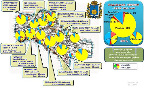
According to the Russian Empire Census on 28 January [O.S. 15 January] 1897, the Podolia Governorate had a population of 3,018,299, including 1,505,940 men and 1,512,359 women. The majority of the population indicated Little Russian[b] to be their mother tongue, with a significant Jewish speaking minority.[2]
| Language | Native speakers | Percentage |
|---|---|---|
| Little Russian[b] | 2,442,819 | 80.93 |
| Jewish | 369,306 | 12.24 |
| Great Russian[b] | 98,984 | 3.28 |
| Polish | 69,156 | 2.29 |
| Romanian | 26,764 | 0.89 |
| German | 4,069 | 0.13 |
| Tatar | 2,296 | 0.08 |
| Bashkir | 1,113 | 0.04 |
| Czech | 886 | 0.03 |
| White Russian[b] | 834 | 0.03 |
| Roma | 510 | 0.02 |
| Votyak | 254 | 0.01 |
| French | 245 | 0.01 |
| Chuvash | 137 | 0.00 |
| Mordovian | 136 | 0.00 |
| Latvian | 112 | 0.00 |
| Cheremis | 101 | 0.00 |
| Other languages | 577 | 0.02 |
| TOTAL | 3,018,299 | 100.00 |
| Faith | Male | Female | Both | |
|---|---|---|---|---|
| Number | Percentage | |||
| Eastern Orthodox | 1,180,148 | 1,178,349 | 2,358,497 | 78.14 |
| Judaism | 179,612 | 191,000 | 370,612 | 12.28 |
| Roman Catholic | 131,145 | 131,593 | 262,738 | 8.70 |
| Old Believer | 9,357 | 9,492 | 18,849 | 0.62 |
| Lutheran | 2,020 | 1,795 | 3,815 | 0.13 |
| Islam | 3,427 | 33 | 3,460 | 0.11 |
| Armenian Apostolic | 65 | 29 | 94 | 0.00 |
| Reformed | 30 | 26 | 56 | 0.00 |
| Armenian Catholic | 23 | 14 | 37 | 0.00 |
| Karaite | 11 | 13 | 24 | 0.00 |
| Anglican | 3 | 4 | 7 | 0.00 |
| Mennonite | 2 | 1 | 3 | 0.00 |
| Baptist | 1 | 1 | 2 | 0.00 |
| Other Christian denomination | 12 | 9 | 21 | 0.00 |
| Other non-Christian denomination | 84 | 0 | 84 | 0.00 |
| Total | 1,505,940 | 1,512,359 | 3,018,299 | 100.00 |

- Religious structures
- Churches
- Eastern Orthodox 1645
- Roman Catholic (kosciol) 202
- Lutheran 4
- Monasteries
- Eastern Orthodox 7 (male), 4 (female)
- Synagogues 89
- other Shul(s) 438
- Mosque(s) 1
See also
Notes
- ↑
- Russian: Подо́льская губе́рния, pre-1918: Подо́льская губе́рнія, romanized: Podólʼskaya gubérniya
- Ukrainian: Поді́льська губе́рнія, romanized: Podílʼsʼka hubérniia
- 1234Prior to 1918, the Imperial Russian government classified Russians as the Great Russians, Ukrainians as the Little Russians, and Belarusians as the White Russians. After the creation of the Ukrainian People's Republic in 1918, the Little Russians identified themselves as "Ukrainian".[3] Also, the Belarusian Democratic Republic which the White Russians identified themselves as "Belarusian".[4]
References
- 12Енциклопедія українознавства. Словникова частина (ЕУ-II). Vol. 2. 1993. pp. 456–460.
- 12"Demoscope Weekly – Annex. Statistical indicators reference". demoscape.ru. Retrieved 19 March 2023.
- ↑Hamm, Michael F. (2014). Kiev: A Portrait, 1800–1917. Princeton University Press. p. 83. ISBN 978-1-4008-5151-5.
- ↑ فورتسون الرابع، بنيامين و. (2011). اللغة والثقافة الهندو-أوروبية: مقدمة . جون وايلي وأولاده. ص 429. ISBN 978-1-4443-5968-8.
- ↑ديموسكوب ويكلي - عرض. إحصائية رسمية.demoscope.ru (باللغة الروسية) . تم الاطلاع عليه بتاريخ 3 مايو 2023 .
48°40′50″ شمالاً 26°34′50″ شرقاً / 48.6806° شمالاً 26.5806° شرقاً / 48.6806; 26.5806
- محافظة بودوليا
- محافظات الإمبراطورية الروسية
- محافظات أوكرانيا
- مؤسسات تسعينيات القرن الثامن عشر في الإمبراطورية الروسية
- تم إلغاء تأسيس الولايات والأقاليم في عام 1925