
التطور الإقليمي للولايات المتحدة
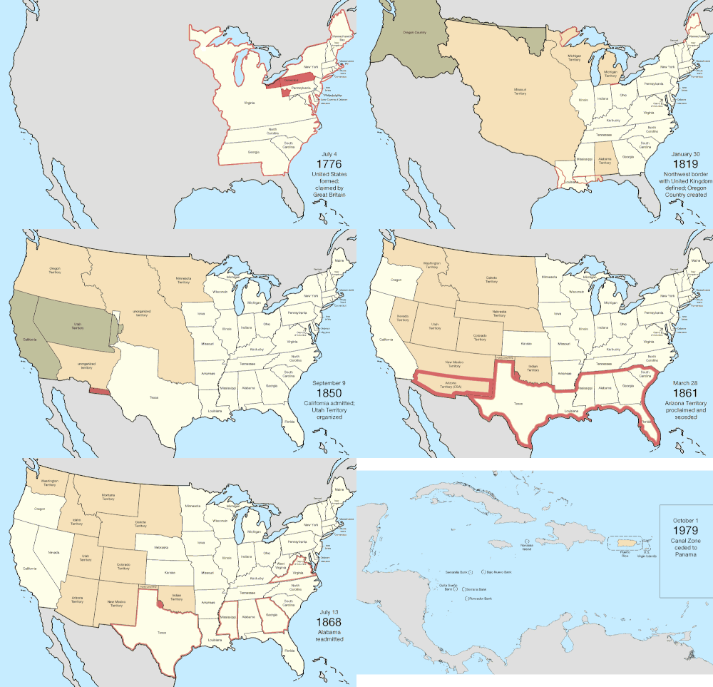

تأسست الولايات المتحدة الأمريكية بعد أن أعلنت ثلاث عشرة مستعمرة بريطانية في أمريكا الشمالية استقلالها عن الإمبراطورية البريطانية في 4 يوليو 1776. وفي قرار لي ، الذي أقره المؤتمر القاري الثاني قبل يومين، قررت المستعمرات أنها دول حرة ومستقلة. وتم إضفاء الطابع الرسمي على الاتحاد في مواد الكونفدرالية ، التي دخلت حيز التنفيذ في 1 مارس 1781، بعد تصديق جميع الولايات الثلاث عشرة عليها. واعترفت بريطانيا العظمى باستقلالها في معاهدة باريس عام 1783، التي أنهت حرب الاستقلال الأمريكية . وقد وسعت هذه المعاهدة حدود الدولة الجديدة غربًا متجاوزة خط الإعلان حتى نهر المسيسيبي . وتم تنظيم هذه الأراضي في أقاليم ثم ولايات، على الرغم من استمرار بعض النزاعات حول المنح الممتدة من المحيط إلى المحيط التي طالبت بها بعض المستعمرات الأصلية. وبمرور الوقت، تم التنازل عن هذه المنح للحكومة الفيدرالية.
شهدت البلاد أول توسع كبير لها مع صفقة شراء لويزيانا عام 1803، والتي ضاعفت مساحة البلاد، على الرغم من أن الحدود الجنوبية الشرقية مع فلوريدا الإسبانية كانت محل نزاع كبير حتى تم التنازل عنها، إلى جانب المطالبات الإسبانية بمنطقة أوريغون ، للولايات المتحدة عام 1821. أتاحت منطقة أوريغون للولايات المتحدة منفذًا إلى المحيط الهادئ ، وإن كانت مشتركة لفترة مع المملكة المتحدة . أدى ضم جمهورية تكساس عام 1845 مباشرةً إلى الحرب المكسيكية الأمريكية ، والتي انتصرت فيها الولايات المتحدة وحصلت على النصف الشمالي من أراضي المكسيك ، بما في ذلك ما أصبح لاحقًا ولاية كاليفورنيا .
مع توسع البلاد غربًا، برزت قضية العبودية بشكل متزايد، مع نقاش حول ما إذا كانت الأراضي الجديدة ستسمح بها، وعكست أحداث مثل تسوية ميسوري و "كانساس الدامية" هذا التوتر. أعلنت حكومات الولايات الجنوبية انفصالها في عامي 1860 و1861، مُشكلةً الولايات الكونفدرالية الأمريكية . انتهت الحرب الأهلية الأمريكية بهزيمة الكونفدرالية عام 1865، وعودة الولايات الجنوبية لاحقًا إلى الكونغرس .
بدأت الولايات المتحدة بالتوسع خارج أمريكا الشمالية عام 1856 مع إقرار قانون جزر غوانو ، مما أدى إلى المطالبة بالعديد من الجزر الصغيرة غير المأهولة، ولكنها ذات أهمية اقتصادية، في البحر الكاريبي والمحيط الهادئ. تم التخلي عن معظم هذه المطالبات لاحقًا، ويعود ذلك في الغالب إلى المطالبات المنافسة من دول أخرى. بلغ التوسع في المحيط الهادئ ذروته بضم هاواي عام 1898، بعد الإطاحة بحكومتها قبل خمس سنوات. أما ألاسكا ، آخر الجزر التي تم ضمها بشكل رئيسي في أمريكا الشمالية، فقد تم شراؤها من روسيا عام 1867. أدى دعم استقلال كوبا عن الإمبراطورية الإسبانية ، وغرق السفينة الحربية الأمريكية " يو إس إس مين" ، إلى اندلاع الحرب الإسبانية الأمريكية عام 1898، والتي فازت فيها الولايات المتحدة ببورتوريكو وغوام والفلبين ، واحتلت كوبا لعدة سنوات. تم ضم ساموا الأمريكية عام 1900 بعد انتهاء الحرب الأهلية الساموية الثانية . واشترت الولايات المتحدة جزر العذراء الأمريكية من الدنمارك عام 1917.
بعد الحرب، عهدت الأمم المتحدة بالعديد من الجزر إلى الولايات المتحدة ، وبينما أصبحت جزر ماريانا الشمالية إقليمًا أمريكيًا، انبثقت جزر مارشال وولايات ميكرونيزيا الموحدة وبالاو من الإقليم المشمول بالوصاية كدول مستقلة. وكان آخر تغيير دولي كبير هو ضم منطقة قناة بنما عام 1904، ثم إعادتها إلى بنما عام 1979، وهي منطقة أمريكية غير مدمجة كانت تُسيطر على قناة بنما . واكتمل النقل النهائي للسيطرة الرسمية على المنطقة إلى بنما عام 1999.
احتفظت الولايات عمومًا بحدودها الأصلية بعد تأسيسها. ثلاث ولايات فقط ( كنتاكي ، ومين ، وفرجينيا الغربية ) أُنشئت مباشرةً من أراضٍ تابعة لولاية أخرى (مع أن فيرمونت وافقت عند انضمامها على دفع مبلغ مالي لنيويورك مقابل تنازلها عن مطالبتها)؛ أما باقي الولايات فقد أُنشئت من أراضٍ اتحادية أو من خلال عمليات استحواذ. توسعت أربع ولايات ( لويزيانا ، وميسوري ، ونيفادا ، وبنسلفانيا ) بشكل كبير من خلال الاستحواذ على أراضٍ اتحادية إضافية بعد انضمامها الأولي إلى الاتحاد . في عام ١٩١٢، كانت أريزونا آخر ولاية تُنشأ في الولايات المتحدة المتصلة . وفي عام ١٩٥٩، أصبحت هاواي الولاية الخمسين والأحدث انضمامًا.
1776–1784 (الثورة الأمريكية)
| تاريخ | الحدث [ أ ] | تغيير الخريطة |
|---|---|---|
| 4 يوليو 1776 | أعلنت ثلاث عشرة مستعمرة تابعة لمملكة بريطانيا العظمى في أمريكا الشمالية استقلالها بشكل جماعي باسم الولايات المتحدة الأمريكية، [ ب ] [ أ ] على الرغم من أن العديد من المستعمرات كانت قد أعلنت استقلالها بشكل فردي بالفعل:
لم يتم تحديد العاصمة بشكل محدد؛ في ذلك الوقت، كان المؤتمر القاري يجتمع في فيلادلفيا . [ 45 ] كانت حدود العديد من الولايات غير واضحة المعالم عند الاستقلال، ولم تُرسَم خرائط كاملة إلا لحدودها الشرقية القصوى. وكانت حدود ولاية كارولاينا الشمالية تحديداً غير مُرَسَّمة بدقة، إذ رُسمت حدودها مع ولاية كارولاينا الجنوبية على مراحل، لم يُطابق أيٌّ منها روح الميثاق، [ 46 ] [ 47 ] وانحرفت حدودها مع ولاية فرجينيا عدة أميال شمالاً عن الوضع الأمثل. زعمت ولاية فرجينيا سيادتها على المنطقة الشمالية الغربية الشاسعة عبر نهر أوهايو ، كما زعمت ولايات كونيتيكت وخليج ماساتشوستس ونيويورك أيضاً سيادتها على مناطق تقع غرب حدودها المستقرة، متداخلة مع مطالبة فرجينيا. [ 48 ] كانت بعض المستعمرات تتمتع بمنح تاريخية تمتد من المحيط الأطلسي إلى المحيط الهادئ، لكن المطالبات البريطانية غرب نهر المسيسيبي تم التخلي عنها لصالح مطالبات فرنسا في لويزيانا بموجب معاهدة باريس عام 1763. وقد حدد الإعلان الملكي لعام 1763 نطاق استيطان المستعمرات الثلاث عشرة شرق جبال الأبلاش، لكن المستعمرات التي أصبحت ولايات استمرت في المطالبة بأراضٍ غرب هذا الخط. ومنح قانون كيبيك لعام 1774 أراضي بين البحيرات العظمى ونهر المسيسيبي ونهر أوهايو (والتي تداخلت جزئيًا مع هذه المطالبات المستمرة) لمستعمرة كيبيك البريطانية الجديدة، وهو مظلمة ذُكرت في إعلان الاستقلال واعتُبرت من القوانين القمعية . طالبت بريطانيا العظمى بكامل أراضي الولايات المتحدة الجديدة، بما في ذلك جزيرة ماتشياس سيل ونورث روك ، وهما جزيرتان صغيرتان قبالة الساحل الشمالي الشرقي لا تزالان محل نزاع حتى الآن. [ 49 ] |  |
| 21 سبتمبر 1776 | أقرت مقاطعات نيو كاسل، وكينت، وساسكس دستورًا لولاية ديلاوير ، لتصبح بذلك ولاية ديلاوير . [ o ] [ 52 ] |  |
| 28 سبتمبر 1776 | سنّت ولاية بنسلفانيا دستورًا ، لتصبح كومنولث بنسلفانيا . [ 31 ] [ 53 ] |  |
| 20 ديسمبر 1776 | ولتجنب القوات البريطانية التي كانت تتقدم نحو فيلادلفيا ، بدأ المؤتمر القاري اجتماعاته في بالتيمور . [ 45 ] |  |
| 17 يناير 1777 | أعلنت المنطقة الشمالية الشرقية من ولاية نيويورك ، والمعروفة باسم منح نيو هامبشاير ، استقلالها تحت اسم نيو كونيتيكت . [ ص ] [ 54 ] [ 56 ] |  |
| 4 مارس 1777 | عاد الكونغرس القاري إلى فيلادلفيا بعد زوال التهديد الذي شكلته القوات البريطانية . [ 45 ] |  |
| 4 يونيو 1777 | أُعيد تسمية ولاية كونيتيكت الجديدة إلى ولاية فيرمونت . [ 54 ] [ 55 ] [ 57 ] |  |
| 27 سبتمبر 1777 | فرّ الكونغرس القاري من فيلادلفيا بعد الهزيمة الأمريكية في معركة برانديواين ، واجتمع لفترة وجيزة في لانكستر، بنسلفانيا . [ 45 ] |  |
| 30 سبتمبر 1777 | واصل الكونغرس القاري ابتعاده عن فيلادلفيا ، واستقر في يورك، بنسلفانيا . [ 45 ] |  |
| 11 يونيو 1778 | ادّعت ولاية فيرمونت أحقيتها فيما يُعرف بـ"الاتحاد الشرقي"، والذي يتألف من بعض البلدات في ولاية نيو هامبشاير [ q ] التي تقدمت بطلب للانضمام إلى فيرمونت، وذلك بسبب قلقها من تركيز ولايتها بشكل مفرط على منطقتها الساحلية. [ 59 ] [ 60 ] [ 61 ] |  |
| 2 يوليو 1778 | عاد الكونغرس القاري إلى فيلادلفيا بعد الانسحاب البريطاني . [ 45 ] |  |
| 21 أكتوبر 1778 | تحت ضغط من الكونغرس القاري ، ألغت ولاية فيرمونت ضمّ الاتحاد الشرقي؛ وأعلن المجلس التشريعي في 12 فبراير 1779 أن الاتحاد الشرقي يُعتبر لاغياً منذ بدايته. [ 59 ] [ 60 ] [ 62 ] |  |
| 25 أكتوبر 1780 | سنّت ولاية خليج ماساتشوستس دستورًا ، لتصبح كومنولث ماساتشوستس . [ 14 ] [ 63 ] |  |
| 1 مارس 1781 | دخلت بنود الاتحاد حيز التنفيذ. [ 64 ] دُعيت مقاطعة كيبيك البريطانية للانضمام، لكنها لم تفعل ذلك. | لم يطرأ أي تغيير على الخريطة |
| 5 أبريل 1781 | طالبت ولاية فيرمونت مرة أخرى باتحاد شرقي، يتألف من بعض البلدات في نيو هامبشاير [ r ] التي رغبت في الانضمام إلى فيرمونت، أكثر مما كان عليه الحال خلال المحاولة الأولى في عام 1778. [ 59 ] [ 60 ] [ 65 ] |  |
| 16 يونيو 1781 | زعمت ولاية فيرمونت أحقيتها فيما كان يُسمى "الاتحاد الغربي"، والذي يتألف من بعض البلدات في نيويورك ، وذلك أساسًا لموازنة محاولة فيرمونت التوسع شرقًا. [ 67 ] [ 60 ] [ 68 ] |  |
| 23 فبراير 1782 | تخلت ولاية فيرمونت عن محاولاتها لضمّ منطقة إيست يونيون من ولاية نيو هامبشاير ومنطقة ويست يونيون من ولاية نيويورك . [ t ] |  |
| 29 أكتوبر 1782 | تم التنازل عن الجزء الغربي من ولاية نيويورك للحكومة الفيدرالية. [ u ] [ 71 ] أعلنت نيويورك أن حدودها الغربية الجديدة هي خط مرسوم جنوبًا من الطرف الغربي لبحيرة أونتاريو . [ 72 ] وفقًا لأقصى تفسير، تنازلت الولاية عن منطقة محددة ببحيرة إيري وبحيرة هورون وبحيرة ميشيغان من الشمال؛ وأنهار إلينوي وميسيسيبي وتينيسي من الغرب والجنوب؛ وجبال الأبلاش وبنسلفانيا من الشرق. [ v ] شمل التنازل طرف نيويورك شمال بنسلفانيا ، والذي سيُعرف باسم مثلث إيري . [ 75 ] |  |
| 30 ديسمبر 1782 | أعلن كونغرس الكونفدرالية أن المنطقة التي ادعت ولاية كونيتيكت أنها مقاطعة ويستمورلاند هي جزء من ولاية بنسلفانيا ، في محاولة لإنهاء حرب بنسلفانيا-يانكي . [ 76 ] [ 77 ] |  |
| 30 يونيو 1783 | أدى تمرد بنسلفانيا ، ورفض الولاية إيقافه، إلى مغادرة كونغرس الكونفدرالية فيلادلفيا إلى برينستون . [ 45 ] |  |
| 26 نوفمبر 1783 | انعقد مؤتمر الكونفدرالية مجدداً في أنابوليس . [ 45 ] |  |
| 1 مارس 1784 | تم التنازل عن مطالبة ولاية فرجينيا الواقعة شمال غرب نهر أوهايو للحكومة الفيدرالية. [ w ] [ 79 ] |  |
| 1 أبريل 1784 | اتفقت ولايتا بنسلفانيا وفرجينيا على تحديد حدودهما بامتداد خط ماسون-ديكسون حتى نقطة تقع على بعد خمس درجات غرب نهر ديلاوير ، ثم شمالاً. [ x ] [ 82 ] [ 83 ] |  |
| 12 مايو 1784 | اعترفت بريطانيا العظمى باستقلال الولايات المتحدة، منهيةً بذلك مطالبتها بالبلاد. [ y ] [ z ] [ 85 ] أنهت المعاهدة حرب الاستقلال الأمريكية ، على الرغم من أن العمل العسكري قد توقف إلى حد كبير بعد انتصار القوات الفرنسية الأمريكية في يوركتاون في 19 أكتوبر 1781. بسبب الغموض وضعف المعرفة بالجغرافيا، كانت المعاهدة غير واضحة في عدة مجالات:
خلال معاهدة باريس ، تنازلت بريطانيا العظمى أيضًا عن فلوريدا لإسبانيا . وأثناء سيطرتها على غرب فلوريدا ، نقلت بريطانيا حدودها شمالًا، وبدا أن التنازل لإسبانيا يشمل كامل مساحة المستعمرة البريطانية. إلا أن المعاهدة البريطانية الأمريكية منحت الولايات المتحدة امتداد غرب فلوريدا، حيث وسّعت البلاد جنوبًا حتى خط عرض 31° شمالًا ، [ aa ] مما يشير إلى أن التعريف الأصلي الأصغر لغرب فلوريدا فقط هو ما سيتم التنازل عنه لإسبانيا. [ 87 ] |   |
1784–1803 (تنظيم الإقليم)
| تاريخ | حدث | تغيير الخريطة |
|---|---|---|
| 23 أغسطس 1784 | أعلنت منطقة في غرب ولاية كارولاينا الشمالية ، غير راضية عن حكم الولاية لها، استقلالها عن الولاية تحت اسم ولاية فرانكلين . [ ab ] [ 89 ] [ 90 ] [ 91 ] قدمت فرانكلين التماسًا للانضمام إلى الاتحاد كولاية، وحصلت على دعم سبع من الولايات التسع المطلوبة، [ J ] لكن هذا لم يدم سوى بضع سنوات. |  |
| 1 نوفمبر 1784 | انتقل مؤتمر الكونفدرالية لفترة قصيرة إلى ترينتون . [ 45 ] |  |
| 11 يناير 1785 | انتقل مؤتمر الكونفدرالية إلى نيويورك ، واستقر هناك لمدة خمس سنوات. [ 45 ] |  |
| 19 أبريل 1785 | تم التنازل عن المطالبة الغربية بولاية ماساتشوستس للحكومة الفيدرالية. [ ac ] [ ad ] [ 79 ] |  |
| 14 سبتمبر 1786 | تم التنازل عن الجزء الغربي من ولاية كونيتيكت ، باستثناء محمية ويسترن ريزيرف ، للحكومة الفيدرالية. [ ae ] [ af ] [ 79 ] |  |
| 4 أكتوبر 1786 | تم تقديم مسح حدود بنسلفانيا - فرجينيا إلى ولاية بنسلفانيا. [ ag ] [ 82 ] [ 95 ] [ 96 ] |  |
| 16 ديسمبر 1786 | تخلت ولاية ماساتشوستس عن مطالبتها بغرب نيويورك . [ 97 ] [ 98 ] [ M ] |  |
| 13 يوليو 1787 | تم تنظيم المنطقة الواقعة وراء نهر أوهايو، والتي تنازلت عنها عدة ولايات للحكومة الفيدرالية، تحت مسمى إقليم شمال غرب نهر أوهايو، والمعروف باسم إقليم الشمال الغربي . [ 100 ] [ شمال ] |  |
| 21 يوليو 1787 | اكتمل مسح الحدود بين ماساتشوستس ونيويورك . [ ah ] [ 97 ] |  |
| 9 أغسطس 1787 | تم التنازل عن الجزء الغربي من ولاية كارولاينا الجنوبية للحكومة الفيدرالية. [ ai ] [ 79 ] إلا أن ذلك كان نتيجةً لخطأ جغرافي، ولم تكن كارولاينا الجنوبية تطالب فعليًا بالمنطقة: فقد كان الادعاء يقتصر على شريط بين حدود كارولاينا الشمالية ومنبع نهر توغالو ، ولكن لم يكن معروفًا آنذاك أن النهر ينبع من كارولاينا الشمالية. أُعطي الجزء الشرقي من هذا التنازل لولاية جورجيا عام 1802، على الرغم من أن جورجيا كانت تطالب بالمنطقة من الناحية الفنية. [ 105 ] [ 106 ] |  |
| 7 ديسمبر 1787 | أصبحت ولاية ديلاوير أول ولاية تصادق على دستور الولايات المتحدة . [ 107 ] | لم يطرأ أي تغيير على الخريطة |
| 12 ديسمبر 1787 | أصبحت ولاية بنسلفانيا ثاني ولاية تصادق على الدستور . [ 107 ] | |
| 18 ديسمبر 1787 | أصبحت ولاية نيوجيرسي ثالث ولاية تصادق على الدستور . [ 107 ] | |
| 2 يناير 1788 | أصبحت جورجيا الولاية الرابعة التي تصادق على الدستور . [ 107 ] | |
| 9 يناير 1788 | أصبحت ولاية كونيتيكت خامس ولاية تصادق على الدستور . [ 107 ] | |
| 6 فبراير 1788 | أصبحت ولاية ماساتشوستس الولاية السادسة التي تصادق على الدستور . [ 107 ] | |
| 28 أبريل 1788 | أصبحت ولاية ماريلاند الولاية السابعة التي تصادق على الدستور . [ 107 ] | |
| 23 مايو 1788 | أصبحت ولاية كارولاينا الجنوبية الولاية الثامنة التي تصادق على الدستور . [ 107 ] | |
| 21 يونيو 1788 | أصبحت نيو هامبشاير الولاية التاسعة التي تصادق على الدستور ؛ عند هذه النقطة، أصبح الدستور الوثيقة الحاكمة الفعلية لتلك الولايات التسع التي صادقت عليه. [ 107 ] | |
| 25 يونيو 1788 | أصبحت ولاية فرجينيا الولاية العاشرة التي تصادق على الدستور . [ 107 ] | |
| 26 يوليو 1788 | أصبحت نيويورك الولاية الحادية عشرة التي تصادق على الدستور . [ 107 ] | |
| فبراير 1789 | أعلن جون سيفير ، حاكم ولاية فرانكلين ، ولاءه لولاية كارولاينا الشمالية خلال جلسة محكمة مقاطعة غرين في فبراير ، مما أنهى فعلياً استقلال فرانكلين المزعوم. [ 89 ] [ 108 ] |  |
| 7 أغسطس 1789 | أُعيد تنظيم إقليم الشمال الغربي بموجب الدستور . [ R ] | لم يطرأ أي تغيير على الخريطة |
| 29 سبتمبر 1789 | وافقت ولاية بنسلفانيا على مسح الحدود بين نيويورك وبنسلفانيا . [ aj ] [ 109 ] [ 110 ] [ S ] |  |
| 21 نوفمبر 1789 | أصبحت ولاية كارولاينا الشمالية الولاية الثانية عشرة التي تصادق على الدستور . [ 107 ] | لم يطرأ أي تغيير على الخريطة |
| 2 أبريل 1790 | تم التنازل عن مطالبة ولاية كارولاينا الشمالية الواقعة غرب جبال سموكي العظيمة للحكومة الفيدرالية. [ ak ] [ 79 ] |  |
| 26 مايو 1790 | تم تنظيم المنطقة التي تنازلت عنها ولاية كارولاينا الشمالية مؤخراً تحت مسمى إقليم جنوب نهر أوهايو، والمعروف باسم إقليم الجنوب الغربي . [ 112 ] [ U ] |  |
| 29 مايو 1790 | أصبحت رود آيلاند الولاية الثالثة عشرة التي تصادق على الدستور . [ 107 ] | لم يطرأ أي تغيير على الخريطة |
| 10 أكتوبر 1790 | اكتمل مسح حدود مثلث نيويورك - إيري . [ al ] [ 109 ] |  |
| 6 ديسمبر 1790 | أُسست فيلادلفيا عاصمةً لمدة عشر سنوات ريثما يتم تجهيز منطقة فيدرالية . [ 45 ] [ V ] |  |
| 4 مارس 1791 | انضمت ولاية فيرمونت ، التي كانت تُعتبر جزءًا من نيويورك رغم استقلالها منذ عام 1777 ، إلى الولايات المتحدة لتصبح الولاية الرابعة عشرة . |  |
| 30 مارس 1791 | تم تشكيل منطقة اتحادية [ ao ] كان من المفترض أن تضم الحكومة بحلول عام 1800 من مناطق تنازلت عنها ولايتا ماريلاند وفرجينيا ، [ ap ] [ V ] تتكون من شكل ماسي، طول كل جانب منه 10 أميال، وتقع نهايته الجنوبية عند جونز بوينت، وتمتد على نهر بوتوماك . [ 121 ] |  |
| 3 مارس 1792 | اشترت ولاية بنسلفانيا منطقة مثلث إيري من الحكومة الفيدرالية. [ aq ] [ 75 ] |  |
| 1 يونيو 1792 | تم قبول النصف الغربي من ولاية فرجينيا كولاية خامسة عشرة، وهي ولاية كنتاكي . [ ar ] [ as ] [ 126 ] [ 127 ] [ AB ] |  |
| 12 يونيو 1792 | سنّت ولاية ديلاوير دستوراً جديداً ، لتصبح بذلك ولاية ديلاوير . [ 50 ] [ 128 ] |  |
| 1 يناير 1793 | اكتمل مسح حدود المقاطعة الفيدرالية . [ ag ] [ 129 ] [ 130 ] |  |
| 25 أبريل 1796 | تنازلت إسبانيا عن النصف الشمالي من غرب فلوريدا ، مما حلّ النزاع حول المنطقة. [ at ] [ 132 ] |  |
| 1 يونيو 1796 | تم قبول إقليم الجنوب الغربي كولاية سادسة عشرة، وهي ولاية تينيسي . [ 133 ] [ 134 ] [ ميلادي ] |  |
| 7 أبريل 1798 | رداً على قضية الاحتيال في أراضي يازو ، صدر قانونٌ يُجيز التفاوض مع جورجيا بشأن التنازل عن مطالبتها الغربية؛ كما أنشأ القانون إقليم ميسيسيبي من المنطقة التي تنازلت عنها فلوريدا الغربية مؤخراً . [ 135 ] [ I ] |  |
| 25 أكتوبر 1798 | اتفق المفوضون على منبع نهر سانت كروا ، مما حدد الحدود الشرقية القصوى مع بريطانيا العظمى . [ 136 ] [ 137 ] |  |
| 13 يناير 1800 | وافقت ولاية فرجينيا على مسح حدود كنتاكي - فرجينيا . [ au ] [ 138 ] [ AE ] |  |
| 10 أبريل 1800 | اكتمل مسح الحدود الجنوبية على طول خط عرض 31° شمالاً . [ av ] [ 141 ] |  |
| 30 مايو 1800 | تم التنازل عن محمية كونيتيكت الغربية للحكومة الفيدرالية؛ ومن المفترض أنها كانت تُعتبر آنذاك جزءًا من إقليم الشمال الغربي . [ aw ] [ 71 ] [ 74 ] |  |
| 4 يوليو 1800 | تم تنظيم إقليم إنديانا من النصف الغربي لإقليم الشمال الغربي . [ ax ] [ 143 ] [ AG ] |  |
| 17 نوفمبر 1800 | انتقل الكونغرس الأمريكي إلى واشنطن ، التي تم بناؤها الآن وأصبحت جاهزة لتكون العاصمة. [ 45 ] |  |
| 27 فبراير 1801 | تم تنظيم المقاطعة الفيدرالية باسم مقاطعة كولومبيا . [ 144 ] [ AH ] |  |
| 16 يونيو 1802 | تم التنازل عن الجزء الغربي من أراضي جورجيا ، المعروف باسم أراضي يازو ، للحكومة الفيدرالية. [ 79 ] [ 74 ] وفي الوقت نفسه ، تنازلت الحكومة الفيدرالية لجورجيا عن الجزء الشرقي من المنطقة التي تنازلت عنها كارولاينا الجنوبية سابقًا ، على الرغم من أن جورجيا كانت تمتلك المنطقة من الناحية الفنية، حيث استند التنازل إلى فهم خاطئ للجغرافيا . [ 105 ] |  |
| 1 مارس 1803 | تم قبول النصف الجنوبي من إقليم الشمال الغربي ، بالإضافة إلى جزء صغير من إقليم إنديانا ، كولاية أوهايو السابعة عشرة . [ ba ] [ bb ] [ 149 ] [ AL ] ونُقل ما تبقى من إقليم الشمال الغربي إلى إقليم إنديانا. [ 150 ] كان الحد الغربي خطًا يمتد شمالًا من مصب نهر ميامي العظيم ؛ أما التعريف الفيدرالي للحدود الشمالية فكان خطًا مرسومًا شرقًا من الطرف الجنوبي لبحيرة ميشيغان ، بينما نص دستور أوهايو على أن يمتد الخط من الطرف الجنوبي لبحيرة ميشيغان إلى أقصى رأس شمالي لخليج ماومي . [ 151 ] أدى الارتباك الناجم عن هذه الأوصاف المتضاربة والمعرفة غير الدقيقة بالجغرافيا إلى النزاع حول شريط توليدو . [ 152 ] |  |
| 3 نوفمبر 1803 | تمت الموافقة على مسح الحدود بين ولايتي تينيسي وفرجينيا . [ bc ] [ 153 ] [ 154 ] |  |
| 30 نوفمبر 1803 | تنازلت ولاية كونيتيكت عن " ساوثويك جوغ " لولاية ماساتشوستس ، لإنهاء الخلافات الطويلة الأمد حول حدودهما. [ bd ] [ 156 ] |  |
1803–1818 (شراء لويزيانا)
| تاريخ | حدث | تغيير الخريطة |
|---|---|---|
| 20 ديسمبر 1803 | تم التنازل رسميًا عن صفقة لويزيانا من فرنسا . [ be ] [ 160 ] وسعت هذه الصفقة رقعة البلاد لتشمل حوض نهر المسيسيبي بأكمله ، [ bf ] إلا أن حدود لويزيانا الجنوبية كانت محل نزاع مع إسبانيا : فقد ادعت الولايات المتحدة أن الصفقة تشمل الجزء الغربي من فلوريدا غرب نهر بيرديدو ، بينما ادعت إسبانيا أنها تنتهي عند الحدود الغربية لفلوريدا الغربية؛ [ bg ] [ 162 ] كما كان هناك نزاع على الحدود الجنوبية الغربية مع إسبانيا الجديدة ، حيث ادعت الولايات المتحدة أن نهر سابين هو الحدود، بينما أصرت إسبانيا على أنه نهر كالكسيو وغيره. [ 163 ] |   |
| 27 مارس 1804 | تم ضم المنطقة الواقعة بين ولايتي تينيسي وميسيسيبي، والتي تنازلت عنها جورجيا سابقاً، إلى إقليم ميسيسيبي. [ 135 ] [ AO ] |  |
| 1 أكتوبر 1804 | تم تنظيم إقليم أورليانز من منطقة لويزيانا جنوب خط عرض 33° شمالاً ، بينما تم تسمية الجزء المتبقي بمقاطعة لويزيانا ووضعه تحت ولاية إقليم إنديانا . [ 164 ] [ AP ] |  |
| 30 يونيو 1805 | تم تنظيم إقليم ميشيغان من إقليم إنديانا ، شمال خط يمتد شرقاً من الطرف الجنوبي لبحيرة ميشيغان ، وشرق خط يمتد شمالاً من الطرف الشمالي للبحيرة. [ 165 ] [ AQ ] |  |
| 4 يوليو 1805 | تم تنظيم مقاطعة لويزيانا باسم إقليم لويزيانا . [ 164 ] [ AR ] |  |
| 1 مارس 1809 | تم تنظيم إقليم إلينوي من النصف الغربي لإقليم إنديانا . [ bh ] [ 166 ] [ AS ] |  |
| 26 سبتمبر 1810 | أعلنت جمهورية غرب فلوريدا استقلالها عن إسبانيا ، مطالبةً بمنطقة غرب فلوريدا الواقعة غرب نهر بيرل . [ 167 ] [ 168 ] |  |
| 10 ديسمبر 1810 | استولت القوات العسكرية الأمريكية على الجزء الغربي من فلوريدا غرب نهر بيرل ، والذي كانت تعتبره جزءًا من صفقة لويزيانا، بما في ذلك المنطقة التي شكلت جمهورية غرب فلوريدا . [ 167 ] [ 169 ] [ 170 ] |  |
| 30 أبريل 1812 | تم قبول معظم أراضي أورليانز كولاية ثامنة عشرة، وهي لويزيانا . [ bi ] [ 172 ] [ AT ] |  |
| 14 مايو 1812 | تم تخصيص الجزء المطالب به من غرب فلوريدا شرق نهر بيرل لإقليم المسيسيبي . [ 135 ] [ AU ] |  |
| 4 أغسطس 1812 | أُضيفت الأجزاء المتبقية من غرب فلوريدا ، الواقعة غرب نهر بيرل ، إلى لويزيانا . [ bj ] [ 164 ] |  |
| 7 ديسمبر 1812 | وبما أن اسمها أصبح مشتركاً مع ولاية لويزيانا ، فقد أعيد تنظيم إقليم لويزيانا ليصبح إقليم ميسوري . [ 174 ] [ AX ] |  |
| 24 أغسطس 1814 | استولت القوات البريطانية على واشنطن وأحرقتها ، لكنها اضطرت للانسحاب في اليوم التالي. لم تتوقف وظائف العاصمة إلا لفترة وجيزة، على الرغم من أن الرئيس جيمس ماديسون لجأ إلى بروكفيل بولاية ماريلاند . [ 175 ] | لم يطرأ أي تغيير على الخريطة |
| 25 أكتوبر 1814 | تم تقديم مسح حدود نيويورك - فيرمونت . [ ag ] [ 176 ] [ 177 ] |  |
| 25 أكتوبر 1815 | اكتمل الجزء الأخير من مسح حدود ولايتي كارولاينا الشمالية والجنوبية . [ ag ] [ 178 ] |  |
| 11 ديسمبر 1816 | تم قبول الجزء الجنوبي من إقليم إنديانا ، إلى جانب أجزاء صغيرة من إقليمي إلينوي وميشيغان ، لتصبح الولاية التاسعة عشرة، إنديانا . [ bk ] [ 143 ] [ AY ] |  |
| 3 مارس 1817 | تم تنظيم إقليم ألاباما من النصف الشرقي لإقليم مسيسيبي . [ bl ] [ 171 ] [ AZ ] |  |
| 10 ديسمبر 1817 | تم قبول إقليم المسيسيبي كولاية رقم 20، وهي ولاية المسيسيبي . [ 179 ] [ BA ] |  |
| 30 يونيو 1818 | بموجب بنود معاهدة غنت التي أنهت حرب 1812 ، تبادلت الولايات المتحدة والمملكة المتحدة [ bm ] عدة جزر تم الاستيلاء عليها خلال الحرب، حيث أعادت جزيرة موس إلى ماساتشوستس ، وجزيرة كامبوبيلو ، وجزيرة دير ، وجزيرة غراند مانان إلى المملكة المتحدة. [ 180 ] [ 181 ] | غير مُحدد على الخريطة |
| 3 ديسمبر 1818 | تم قبول نصف إقليم إلينوي الواقع جنوب خط عرض 42°30′ شمالاً كولاية إلينوي الحادية والعشرين . [ 182 ] أما باقي الإقليم، بالإضافة إلى الأراضي غير المنظمة التي كانت مؤخراً جزءاً من إقليم إنديانا ، فقد تم ضمها إلى إقليم ميشيغان . [ BB ] |  |
1819–1845 (التوسع الشمالي الغربي)
| تاريخ | حدث | تغيير الخريطة |
|---|---|---|
| 30 يناير 1819 | حددت معاهدة عام 1818 خط عرض 49 ° شمالاً كحدود مع المملكة المتحدة غرب بحيرة وودز ، وأرست منطقة أوريغون كمنطقة مشتركة مع المملكة المتحدة. [ bn ] [ bo ] [ 184 ] |   |
| 4 يوليو 1819 | تم تنظيم إقليم أركنساس من الجزء الجنوبي من إقليم ميسوري . [ bp ] [ 186 ] [ BD ] |  |
| 30 أكتوبر 1819 | وافقت ولاية تينيسي على مسح حدود جورجيا مع تينيسي. [ 187 ] [ BE ] أما الخط الذي تم مسحه جنوب خط عرض 35° شمالاً بقليل ، والذي يفصل جورجيا عن نهر تينيسي ، فلم توافق عليه جورجيا قط. [ 189 ] |  |
| 14 ديسمبر 1819 | تم قبول إقليم ألاباما كولاية ثانية وعشرين، ألاباما . [ 190 ] [ BF ] |  |
| 15 مارس 1820 | كجزء من تسوية ميسوري ، تم قبول مقاطعة مين ، وهي الجزء الشمالي والمنفصل من ماساتشوستس ، لتصبح الولاية الثالثة والعشرين، مين . [ 191 ] [ BG ] |  |
| 21 أبريل 1820 | هذا هو أقدم تاريخ معروف لاستخدام اسم " إقليم أركنساس " رسميًا بدلاً من "إقليم أركنساو". [ BH ] |  |
| 12 مايو 1820 | تمت الموافقة على مسح حدود كنتاكي وتينيسي من الشرق إلى كلير فورك ، ومن نهر كمبرلاند إلى نهر تينيسي . [ bq ] [ 193 ] [ 194 ] |  |
| 19 يوليو 1820 | اكتمل مسح الحدود بين ولايتي ألاباما وميسيسيبي . [ ag ] [ br ] [ 89 ] [ 195 ] |  |
| 1821 | اكتمل مسح حدود جورجيا - كارولاينا الشمالية في عام 1821. [ ag ] [ 196 ] [ 197 ] |  |
| 22 فبراير 1821 | دخلت معاهدة آدمز -أونيس مع إسبانيا حيز التنفيذ. [ bs ] [ 162 ] وشملت التغييرات العديدة ما يلي:
|   |
| 2 يوليو 1821 | اكتمل مسح الحدود بين ولايتي إلينوي وإنديانا . [ ag ] [ 166 ] [ 199 ] |  |
| 10 يوليو 1821 | تم نقل شرق فلوريدا رسميًا إلى الولايات المتحدة من قبل إسبانيا . [ 200 ] |  |
| 17 يوليو 1821 | تم نقل غرب فلوريدا رسميًا إلى الولايات المتحدة من قبل إسبانيا . [ 201 ] |  |
| 10 أغسطس 1821 | تم قبول الركن الجنوبي الشرقي من إقليم ميسوري كولاية رابعة وعشرين، وهي ولاية ميسوري . [ bu ] [ 204 ] [ BL ] |  |
| 19 نوفمبر 1821 | تمت الموافقة على مسح الحدود بين ولايتي كارولاينا الشمالية وتينيسي من قبل ولاية كارولاينا الشمالية. [ bv ] [ 196 ] |  |
| 22 نوفمبر 1821 | تمت الموافقة على دراسة الفجوة في المسح السابق لحدود كنتاكي وتينيسي . [ bw ] [ 193 ] |  |
| 30 مارس 1822 | تم تنظيم منطقتي شرق فلوريدا وغرب فلوريدا السابقتين تحت مسمى إقليم فلوريدا . [ 206 ] [ BN ] |  |
| 26 مايو 1824 | تم نقل الحدود الغربية لإقليم أركنساس شرقًا إلى خط جنوبي من نقطة تبعد 40 ميلاً غرب الحدود الغربية لولاية ميسوري . [ 185 ] [ BO ] |  |
| 11 يناير 1825 | تم تحديد خط 54°40′ شمالاً كحدود شمالية لمقاطعة أوريغون بموجب معاهدة مع الإمبراطورية الروسية ؛ [ bx ] تم إنشاء نفس الحدود بين روسيا والمملكة المتحدة بموجب معاهدة منفصلة . |  |
| 3 نوفمبر 1826 | تم إجراء تعديل على حدود كونيتيكت وماساتشوستس لتصحيح انحراف طفيف للغاية . [ 208 ] | غير مُحدد على الخريطة |
| 28 مايو 1828 | تم تحريك الحدود الغربية لإقليم أركنساس شرقًا مرة أخرى، مما أدى إلى التنازل عن أراضٍ لقبيلة الشيروكي . [ بواسطة ] [ بز ] [ 185 ] |  |
| 1 يوليو 1829 | تمت الموافقة على مسح الحدود بين ولايتي مين ونيو هامبشاير . [ ca ] [ 211 ] |  |
| 10 يناير 1831 | بعد أن طُلب من الملك ويليام الأول ملك هولندا ، بموجب معاهدة غنت، التحكيم في النزاع الحدودي بين ولاية مين والمملكة المتحدة ، أصدر قراره: نظرًا لصعوبة التوفيق بين المعاهدة والخرائط المقدمة، رسم خطًا وسطًا. قبلت المملكة المتحدة هذا الخط، لكن الولايات المتحدة رفضته. [ 212 ] [ BS ] | لم يطرأ أي تغيير على الخريطة |
| 20 ديسمبر 1831 | تمت الموافقة على مسح الجزء الغربي والأخير من حدود كنتاكي - تينيسي . [ cb ] |  |
| 9 يوليو 1832 | أعلنت منطقة نيو هامبشاير الواقعة شمال بحيرات كونيتيكت ، والتي كانت محل نزاع مع المملكة المتحدة ، استقلالها تحت اسم جمهورية إنديان ستريم . [ 214 ] [ 215 ] |  |
| 28 يونيو 1834 | اكتسبت منطقة ميشيغان مساحة كبيرة من الأراضي غير المنظمة، وامتدت غربًا إلى نهر ميسوري ونهر وايت إيرث . [ 165 ] [ BT ] |  |
| 5 أغسطس 1835 | اعترفت جمهورية إنديان ستريم بسلطة ولاية نيو هامبشاير ، منهيةً بذلك استقلالها المزعوم. [ cc ] [ 214 ] |  |
| 15 يونيو 1836 | تم قبول إقليم أركنساس كولاية خامسة وعشرين، أركنساس . [ cd ] [ 217 ] [ BU ] |  |
| 23 يونيو 1836 | تمت الموافقة على مسوحات الحدود الشمالية لولايات إلينوي وإنديانا وأوهايو . [ ce ] [ 152 ] [ BV ] |  |
| 3 يوليو 1836 | تم تنظيم إقليم ويسكونسن من الجزء الغربي الأكبر من إقليم ميشيغان . [ انظر ] [ 219 ] [ BW ] بقيت شبه الجزيرتين الكبيرتين بين البحيرات العظمى ضمن إقليم ميشيغان؛ وتم ضم شبه الجزيرة العليا مقابل تخلي الإقليم عن مطالبته بشريط توليدو . |  |
| 14 ديسمبر 1836 | وافقت مقاطعة ميشيغان على التخلي عن مطالبتها بمنطقة توليدو ، منهية بذلك نزاعها مع ولاية أوهايو . [ 152 ] [ 220 ] |  |
| 26 يناير 1837 | تم قبول إقليم ميشيغان كولاية سادس وعشرين، ميشيغان . [ 221 ] [ BX ] |  |
| 28 مارس 1837 | تم التنازل عن منطقة بلات ، التي تم الحصول عليها من عدة قبائل بما في ذلك بوتاواتومي ، وأيوا ، وميسوريا ، وأوتو ، وساوك ، وميسكواكي ، [ 222 ] إلى ولاية ميسوري ، مما أدى إلى تمديد حدودها الشمالية غربًا إلى نهر ميسوري . [ cg ] [ 202 ] |  |
| 9 نوفمبر 1837 | وافقت ولاية تينيسي على مسح الحدود بين ولايتي ميسيسيبي وتينيسي . [ الفصل ] [ 223 ] [ CB ] |  |
| 3 يوليو 1838 | تم تنظيم إقليم أيوا من إقليم ويسكونسن غرب نهر المسيسيبي . [ 225 ] [ CC ] |  |
| 1839 | اكتمل مسح حدود ألاباما وتينيسي في عام 1839. [ ag ] [ 89 ] |  |
| 11 فبراير 1839 | زعمت ولاية ميسوري أحقيتها بمنطقة تقع شمال حدودها مع إقليم أيوا ، مما أدى إلى بدء النزاع الطويل المعروف باسم حرب العسل . [ 226 ] [ CD ] |  |
| 27 يناير 1840 | تمت الموافقة على مسح الحدود بين ألاباما وجورجيا . [ ci ] [ 229 ] |  |
| 24 يونيو 1841 | اكتمل مسح الحدود مع تكساس . [ 210 ] [ CE ] |  |
| 13 أكتوبر 1842 | حددت معاهدة ويبستر-أشبورتون الحدود مع المملكة المتحدة شرق جبال روكي . [ cj ] [ 231 ] حسمت المعاهدة النزاعات حول الحدود الشمالية لولايتي مين ونيو هامبشاير [ ck ] والحدود الشمالية الشرقية لإقليم ويسكونسن ، [ cl ] كما أكدت على أحقية الولايات المتحدة في جزيرة شوغر . [ 231 ] |   |
| 3 مارس 1845 | تم قبول إقليم فلوريدا كولاية رقم 27، فلوريدا . [ 232 ] [ CG ] |  |
1845–1860 (التوسع الجنوبي الغربي)
| تاريخ | حدث | تغيير الخريطة |
|---|---|---|
| 29 ديسمبر 1845 | ضُمّت جمهورية تكساس إلى الولايات المتحدة لتصبح الولاية الثامنة والعشرين، تكساس ، [ cm ] [ 234 ] [ CH ]، ممتدةً بذلك جنوب غرب الولايات المتحدة حتى نهر ريو غراندي . وطالبت المكسيك بكامل تكساس . [ cn ] وأدى هذا الضم إلى اندلاع الحرب المكسيكية الأمريكية بعد بضعة أشهر. [ 233 ] |  |
| 17 يوليو 1846 | حددت معاهدة أوريغون خط عرض 49° شمال غرب بحيرة وودز كحدود قارية مع ممتلكات المملكة المتحدة ، منهيةً بذلك تقاسم أراضي أوريغون . [ co ] [ 236 ] كانت المعاهدة غامضة بشأن المضيق الذي ينبغي أن يكون الحدود بين جزيرة فانكوفر والقارة، مما أدى إلى نزاع حول ملكية جزر سان خوان . [ 184 ] |   |
| 28 ديسمبر 1846 | تم قبول الجزء من إقليم آيوا الواقع جنوب خط عرض 43°30′ شمالاً وشرقاً من نهر بيغ سيوكس كولاية آيوا التاسعة والعشرين . [ cp ] [ 226 ] [ CJ ] |  |
| 20 مارس 1847 | أعادت مقاطعة كولومبيا مقاطعة الإسكندرية إلى ولاية فرجينيا . [ cq ] [ 240 ] |  |
| 28 يونيو 1847 | تم تقديم مسح الحدود مع المملكة المتحدة شرق البحيرات العظمى . [ cr ] [ 236 ] |  |
| 5 نوفمبر 1847 | تم تقديم مسح حدود ولاية ميشيغان وإقليم ويسكونسن . [ ag ] [ 242 ] [ CO ] |  |
| 15 فبراير 1848 | تمت الموافقة على مسح الحدود بين أركنساس وميسوري . [ 210 ] [ CP ] |  |
| 29 مايو 1848 | تم قبول الجزء الجنوبي الأكبر من إقليم ويسكونسن كولاية ويسكونسن ، لتصبح الولاية الثلاثين . [ cs ] [ 243 ] [ CQ ] ومع ذلك، قرر سكان الجزء المتبقي الاستمرار في الحكم المدني، وانتخبوا مندوبًا إلى مجلس النواب الأمريكي الذي شغل منصبه في 15 يناير 1849، مما جعل هذه المنطقة فعليًا امتدادًا لإقليم ويسكونسن. [ 244 ] [ 245 ] |  |
| 30 مايو 1848 | أنهت معاهدة غوادالوبي هيدالغو الحرب المكسيكية الأمريكية ، وتنازلت بموجبها المكسيك عن منطقة واسعة ، تضم أراضيها في كاليفورنيا العليا وسانتا فيه دي نويفو مكسيكو ، بالإضافة إلى مطالبتها بتكساس ؛ [ ct ] [ cu ] ومع ذلك، كان هناك خلاف حول الحدود الجنوبية المحددة لسانتا فيه دي نويفو مكسيكو. [ 247 ] |   |
| 14 أغسطس 1848 | تم تنظيم إقليم أوريغون من مقاطعة أوريغون السابقة . [ 248 ] [ CS ] |  |
| 13 فبراير 1849 | حُسم النزاع الحدودي بين ولايتي أيوا وميسوري ، المعروف باسم حرب العسل، من قبل المحكمة العليا . [ 237 ] وكانت الحدود الناتجة هي خط سوليفان الذي كان قائماً قبل النزاع، والذي يفصل تقريباً بين المنطقتين المتنازع عليهما. [ CT ] |  |
| 3 مارس 1849 | تم تنظيم إقليم مينيسوتا من المنطقة التي كانت تعمل بحكم الأمر الواقع كإقليم ويسكونسن ، والأراضي غير المنظمة شرق نهري ميسوري ووايت إيرث . [ 237 ] [ CU ] |  |
| 12 مارس 1849 | أسس المستوطنون ولاية ديزيريت، وادّعوا ملكية جزء كبير من الجنوب الغربي. ورغم تقديمها التماسًا للانضمام إلى الولايات المتحدة، رُفض الاقتراح، وفي عام 1850، شُكّلت ولاية يوتا بدلًا منها. [ 249 ] [ 250 ] |  |
| 24 نوفمبر 1849 | تم نقل حدود لويزيانا وتكساس من الضفة الغربية إلى منتصف نهر سابين . [ cv ] [ 252 ] [ CW ] | غير مُحدد على الخريطة |
| 9 سبتمبر 1850 | تم قبول الجزء الغربي من الأراضي المكسيكية المتنازل عنها كولاية كاليفورنيا ، الولاية الحادية والثلاثين . [ cw ] [ 254 ] [ CX ] أما الجزء المتبقي شمال خط عرض 37° شمالاً وغرب قمة جبال روكي، فقد تم تنظيمه كإقليم يوتا . [ cx ] [ 249 ] [ CY ] |  |
| 9 ديسمبر 1850 | تنازلت المملكة المتحدة عن أقل من فدان واحد من الصخور المغمورة لبناء منارة في بحيرة إيري بالقرب من بوفالو، نيويورك ؛ [ 255 ] ورغم أنها كانت تقع على الشعاب المرجانية الوسطى، فقد سُميت نسبةً إلى شعاب هورسشو المرجانية المجاورة. [ 256 ] وكانت محاطة بالمياه البريطانية، مما خلق نوعًا من الجيب. [ CN ] |  |
| 13 ديسمبر 1850 | اشترت الحكومة الفيدرالية الجزء الغربي من تكساس . [ cy ] [ 257 ] تم تنظيم إقليم نيو مكسيكو من الجزء الشرقي من هذه المنطقة ، بالإضافة إلى الأراضي المتبقية غير المنظمة من التنازل المكسيكي . [ cz ] [ 259 ] [ CZ ] |  |
| 3 يناير 1851 | أقرت المحكمة العليا مسح الحدود بين ولايتي أيوا وميسوري . [ 237 ] [ DA ] |  |
| 5 أبريل 1851 | حلت ولاية ديزيريت نفسها، حيث تم استبدال وظائفها وأراضيها إلى حد كبير بإقليم يوتا . [ 260 ] |  |
| 11 ديسمبر 1852 | تم تقديم مسح الحدود الغربية لولاية ويسكونسن . [ ag ] [ 225 ] [ 261 ] |  |
| 2 مارس 1853 | تم تنظيم إقليم واشنطن من نصف إقليم أوريغون الواقع شمال خط عرض 46 درجة شمالاً ونهر كولومبيا . [ 262 ] [ DB ] |  |
| 30 مايو 1854 | قام قانون كانساس-نبراسكا بتنظيم إقليم كانساس من الأراضي غير المنظمة الواقعة بين خطي عرض 37° شمالاً و 40° شمالاً ، [ 263 ] وإقليم نبراسكا من الأراضي غير المنظمة الواقعة شمال خط عرض 40° شمالاً. [ 264 ] [ DC ] وأصبح جزء كبير من الأراضي غير المنظمة المتبقية، شرق خط عرض 100° غرباً ، يُعرف باسم الإقليم الهندي ، وقد خُصص كمكان لإعادة توطين القبائل الأصلية. كانت هناك قطعة أرض صغيرة بين منطقة تكساس بانهاندل وإقليم كانساس غير مُطالب بها لأنها تقع جنوب حدود إقليم كانساس ولكن شمال خط عرض 36°30′ شمالاً ، والذي تم تحديده في تسوية ميسوري كحد شمالي للعبودية، وبالتالي لم يكن بإمكان تكساس ضمها. عُرفت هذه المنطقة باسم " شريط الأراضي العامة "، أو أحيانًا "الأرض الحرام". [ 265 ] |  |
| 30 يونيو 1854 | اشترت الولايات المتحدة قطعة أرض كبيرة من المكسيك تُعرف باسم صفقة غادسدن ، لأنها وفرت مسارًا أفضل بكثير لخط سكة حديد عابر للقارات جنوبًا. [ da ] [ db ] وقد حلّ هذا النزاع الحدودي، حيث شملت الصفقة المنطقة المتنازع عليها. [ 267 ] |   |
| 4 أغسطس 1854 | تم تخصيص منطقة غادسدن التي تم الحصول عليها مؤخرًا لإقليم نيو مكسيكو . [ 268 ] [ DE ] |  |
| 11 يناير 1855 | تنازلت ولاية ماساتشوستس عن منطقة بوسطن كورنر لولاية نيويورك بسبب صعوبة الوصول إليها من بقية أنحاء ماساتشوستس. [ dc ] [ 97 ] |  |
| 6 مارس 1855 | أصدرت المحكمة العليا حكماً لصالح ولاية فلوريدا في نزاع حدودي مع ولاية جورجيا ، وحددت خط الولاية على طول خط ماكنيل . [ DG ] | لم يطرأ أي تغيير على الخريطة |
| 1 أغسطس 1856 | تم تقديم مسح الحدود مع المكسيك . [ 267 ] [ DH ] |  |
| 28 أكتوبر 1856 | تمت المطالبة بجزيرة بيكر وجزيرة جارفيس بموجب قانون جزر الجوانو . [ 270 ] [ 271 ] |  |
| 11 مايو 1858 | تم قبول النصف الشرقي من إقليم مينيسوتا كولاية ثانية وثلاثين، وهي مينيسوتا . [ dd ] [ 272 ] [ DI ] |  |
| 31 أغسطس 1858 | تمت المطالبة بجزيرة نافاسا بموجب قانون جزر غوانو ؛ [ 273 ] [ 274 ] كما طالبت بها هايتي . [ de ] |  |
| 3 ديسمبر 1858 | تمت المطالبة بجزيرة هاولاند بموجب قانون جزر غوانو . [ 270 ] [ 271 ] |  |
| 14 فبراير 1859 | تم قبول النصف الغربي من إقليم أوريغون كولاية ثالثة وثلاثين، وهي ولاية أوريغون . [ df ] [ 277 ] أما الجزء المتبقي فقد تم تخصيصه لإقليم واشنطن . [ DL ] |  |
| 6 يوليو 1859 | أنشأ المساحون "إزاحة ميدلتون"، وهي فجوة صغيرة في حدود كنتاكي وتينيسي . ولا يُعرف السبب الدقيق وراء ذلك، إلا أن إحدى النظريات تقول إن أحد ملاك الأراضي المحليين أراد أن تكون أرضه في تينيسي. [ 278 ] [ 279 ] |  |
| 6 سبتمبر 1859 | تمت المطالبة بجزيرة جونستون المرجانية بموجب قانون جزر الجوانو ، [ 280 ] [ 271 ] على الرغم من أن هاواي قد طالبت بها في عام 1858. [ 281 ] |  |
| 7 نوفمبر 1859 | شكّل المستوطنون حكومة مؤقتة لأجزاء من أراضي كانساس ونبراسكا ونيو مكسيكو ويوتا وواشنطن ، وأطلقوا عليها اسم إقليم جيفرسون . [ dg ] ورغم أنها لم تعترف بها الحكومة الفيدرالية قط، إلا أنها استمرت في العمل حتى تأسيس إقليم كولورادو . [ 283 ] |  |
| 27 ديسمبر 1859 | تمت المطالبة بجزيرة إندربوري ، وجزيرة ماكين ، وجزيرة فينيكس ، وجزيرة ستارباك بموجب قانون جزر غوانو . [ 271 ] |  |
| 29 ديسمبر 1859 | تمت المطالبة بجزيرة كريسماس وجزيرة مالدين بموجب قانون جزر غوانو . [ 271 ] |  |
| 8 فبراير 1860 | تم المطالبة بعشرات الجزر في المحيط الهادئ بموجب قانون جزر غوانو ، [ 271 ] بما في ذلك أتافو ، وجزيرة بيرني ، وبوتاريتاري ، وجزيرة كانتون ، وجزيرة كارولين ، وجزيرة فانينغ ، وجزيرة فلينت ، وجزيرة غاردنر ، وشعاب كينغمان المرجانية ، ومانيهيكي ، وماراكي ، وناساو ، ونوكونو ، وجزيرة بالميرا المرجانية ، وبينرين ، وبوكابوكا ، وراكاهانغا ، وجزيرة سوينز ، وجزيرة سيدني ، وجزيرة فوستوك ، وجزيرة واشنطن . [ dh ] |  |
1860–1865 (الحرب الأهلية)
| تاريخ | حدث | تغيير الخريطة |
|---|---|---|
| 20 ديسمبر 1860 | رداً على انتخاب أبراهام لينكولن ، أعلنت ولاية كارولاينا الجنوبية انفصالها عن الاتحاد، وانسحبت من الكونغرس الأمريكي . [ 297 ] |  |
| 9 يناير 1861 | أعلنت ولاية ميسيسيبي انفصالها عن الاتحاد، وانسحبت من الكونغرس. [ 297 ] |  |
| 10 يناير 1861 | أعلنت فلوريدا انفصالها عن الاتحاد، وانسحبت من الكونغرس. [ 297 ] |  |
| 11 يناير 1861 | أعلنت ولاية ألاباما انفصالها عن الاتحاد، وانسحبت من الكونغرس. [ 297 ] |  |
| 19 يناير 1861 | أعلنت جورجيا انفصالها عن الاتحاد، وانسحبت من الكونغرس. [ 297 ] |  |
| 26 يناير 1861 | أعلنت لويزيانا انفصالها عن الاتحاد، وانسحبت من الكونغرس. [ 297 ] ومع ذلك، استمرت الدائرتان الانتخابيتان الأولى والثانية ، حول نيو أورليانز ، في إرسال ممثلين إلى الكونغرس. |  |
| 29 يناير 1861 | تم قبول الجزء الأكبر من إقليم كانساس الواقع شرق خط عرض 25 درجة غرب واشنطن كولاية كانساس الرابعة والثلاثين . [ di ] [ 299 ] [ DM ] |  |
| 8 فبراير 1861 | The Confederate States of America was formed by the seceded states of Alabama, Georgia, Florida, Louisiana, Mississippi, and South Carolina.[300] |  |
| February 28, 1861 | Colorado Territory was organized from portions of Nebraska Territory, New Mexico Territory, and Utah Territory, along with unorganized territory.[dj][283][DN] |  |
| March 2, 1861 | Texas proclaimed its secession from the Union, withdrawing from Congress,[297] and was admitted to the Confederate States.[DO] Dakota Territory was organized from Nebraska Territory and the unorganized territory north of it.[dk] Nebraska Territory's western border was moved to 33° west from Washington, gaining small portions of Utah Territory and Washington Territory.[303][DP]Nevada Territory was organized from Utah Territory west of 39° west from Washington.[304][DQ] |   |
| March 28, 1861 | Representatives in the southern half of New Mexico Territory proclaimed an independent Arizona Territory south of 34° north.[305] |  |
| April 17, 1861 | Following the Battle of Fort Sumter and President Abraham Lincoln's call for troops to respond, Virginiaproclaimed its secession from the Union, withdrawing from Congress.[297] However, the 1st (along the Eastern Shore), 7th (near Washington, D.C.), and 10th, 11th, and 12th (in the northwest of the state) congressional districts continued to send representatives to Congress. |  |
| May 6, 1861 | Arkansas proclaimed its secession from the Union, withdrawing from Congress.[297] |  |
| May 7, 1861 | Virginia was admitted to the Confederate States.[DR] |  |
| May 20, 1861 | Arkansas was admitted to the Confederate States.[DS] North Carolina proclaimed its secession from the Union, withdrawing from Congress.[297] Kentuckydeclared itself neutral in the American Civil War.[308][309] |   |
| May 21, 1861 | North Carolina was admitted to the Confederate States.[dl] |  |
| June 6, 1861 | Robert Williamson Steele, governor of Jefferson Territory, declared the territory disbanded and handed over the government to the first governor of Colorado Territory.[313] |  |
| June 8, 1861 | Tennessee proclaimed its secession from the Union, withdrawing from Congress.[297] However, the 1st, 2nd, 3rd, and 4th congressional districts in the eastern half of the state continued to send representatives to Congress. |  |
| June 25, 1861 | The federal government recognized the Restored Government of Virginia in Wheeling as the legitimate government of Virginia.[314] |  |
| July 2, 1861 | Tennessee was admitted to the Confederate States.[DU] |  |
| August 1, 1861 | Following Confederate victory in the First Battle of Mesilla, Arizona Territory was proclaimed as part of the Confederate States.[317] |  |
| September 13, 1861 | Following the Confederate occupation of Columbus, Kentucky, on September 3, 1861, the state abandoned neutrality and aligned with the Union government.[DV] | no change to map |
| October 31, 1861 | A splinter government in Neosho, Missouri, proclaimed the secession of the state from the Union.[297] |  |
| November 20, 1861 | A convention in Russellville, Kentucky, proclaimed the formation of a splinter government in Bowling Green and the secession of Kentucky from the Union.[297] |  |
| November 28, 1861 | The splinter Neosho government of Missouri was admitted to the Confederate States. The Confederate States never held control over the state, but it was given full representation in the legislature.[DW] |  |
| December 10, 1861 | The splinter Bowling Green government of Kentucky was admitted to the Confederate States. Like Missouri, despite lack of control, it was given full representation in the legislature.[DX] |  |
| December 21, 1861 | The Confederate States ratified treaties with the Great Osage Tribe,[dm] and the Seneca and Shawnee.[dn][do][326] |  |
| December 23, 1861 | The Confederate States ratified treaties with the Cherokee Nation,[dp] granting them a delegate to the Congress of the Confederate States, and with the Seminole Nation,[dq] granting them a delegate to be shared with the Creek Nation.[326] |  |
| December 31, 1861 | The Confederate States ratified treaties with the Choctaw Nation and Chickasaw Nation,[dr]granting them a shared delegate in the Congress of the Confederate States; with the Comanche;[du] with the Creek Nation,[dv] granting them a delegate shared with the Seminole Nation; and with the Quapaw.[dw][326] |  |
| March 1, 1862 | A decree by the Supreme Court modified the Massachusetts–Rhode Island border.[dx][341] |  |
| April 15, 1862 | Palmyra Atoll was annexed by Hawaii, after which the American claim fell dormant.[342][343] |  |
| July 14, 1862 | The slice of Utah Territory west of 38° west from Washington was assigned to Nevada Territory.[304][EH] |  |
| December 30, 1862 | The Swan Islands were claimed under the Guano Islands Act.[270][274] |  |
| February 24, 1863 | Arizona Territory was organized from the half of New Mexico Territory west of 32° west from Washington.[344][EI] |  |
| March 3, 1863 | Idaho Territory was organized from the parts of Dakota Territory and Nebraska Territory west of 27° west from Washington, and the half of Washington Territory east of the Snake River and a line north from the mouth of the Clearwater River.[345][EJ] |  |
| March 4, 1863 | Because of disruption in voting and low turnout, no one was allowed to take the seats in the United States House of Representatives held by the Unionist areas of Louisiana, Tennessee, and Virginia, effectively expelling the states; Virginia maintained representation in the United States Senate.[346] |  |
| June 20, 1863 | The northwestern counties of Virginia, represented by the Restored Government of Virginia in Wheeling, were admitted as the thirty-fifth state, West Virginia.[dy][dz][347] The Restored Government of Virginia was relocated to Alexandria. |  |
| August 5, 1863 | Berkeley County was ceded by Virginia to West Virginia.[ea] |  |
| November 2, 1863 | Jefferson County was ceded by Virginia to West Virginia.[eb] |  |
| May 26, 1864 | Montana Territory was organized from the northeast third of Idaho Territory,[ec][352] and the southeast third of Idaho Territory was assigned to Dakota Territory.[ed][302][ER] |  |
| October 31, 1864 | Nevada Territory was admitted as the thirty-sixth state, Nevada.[ee][353][ES] |  |
| May 5, 1865 | The Confederate States cabinet met in Washington, Georgia, and dissolved.[354] Military surrenders were scattered throughout 1865, but the most important is regarded as that of the Army of Northern Virginia following the Battle of Appomattox Court House on April 9. |  |
1866–1897 (Reconstruction and western statehood)
| Date | Event | Change map |
|---|---|---|
| May 5, 1866 | The slice of Utah Territory west of 37° west from Washington was ceded to Nevada.[ef][304] |  |
| July 24, 1866 | Tennessee was readmitted to Congress.[EV] |  |
| December 13, 1866 | The survey of the Florida–Georgia border was approved.[eg][358][86] |  |
| December 26, 1866 | Starbuck Island was claimed by the United Kingdom.[359] |  |
| January 18, 1867 | The northwestern corner of Arizona Territory, west of the Colorado River and 37° west from Washington, was ceded to Nevada.[eh][ei][304] |  |
| March 1, 1867 | Nebraska Territory was admitted as the thirty-seventh state, Nebraska.[362][FA] |  |
| July 1, 1867 | Canada was formed from several British colonies, including New Brunswick, inheriting the dispute over Machias Seal Island and North Rock. |  |
| August 28, 1867 | Midway Atoll was claimed.[280][FB] |  |
| October 18, 1867 | Alaska was purchased from the Russian Empire and designated the Department of Alaska.[ej][ek][267] A vague description and lack of quality surveying made the southeastern border with British holdings unclear and disputed.[365] |  |
| June 22, 1868 | Arkansas was readmitted to Congress.[FD] |  |
| June 25, 1868 | Florida was readmitted to Congress.[el] |  |
| July 4, 1868 | North Carolina was readmitted to Congress.[em] |  |
| July 9, 1868 | Louisiana and South Carolina were readmitted to Congress.[en] Caroline Island was claimed by the United Kingdom.[366] |   |
| July 13, 1868 | Alabama was readmitted to Congress.[eo] |  |
| July 21, 1868 | Georgia was readmitted to Congress.[ep] |  |
| July 25, 1868 | Wyoming Territory was organized from portions of Dakota, Idaho, and Utah Territories.[eq][er][368] A tiny portion of the Dakota Territory was erroneously left behind on the western side of Wyoming Territory.[369] |  |
| August 12, 1868 | The list of bonded guano island claims mentions "Islands in Caribbean Sea not named" bonded on this date, but it is unknown to what this is referring.[370] | no change to map |
| December 11, 1868 | Serrana Bank was claimed under the Guano Islands Act.[371]Colombia has claimed it throughout its history. |  |
| March 3, 1869 | Georgia was again expelled from Congress; the representatives elected in April 1868 to serve in the last few months of the 40th United States Congress attempted to present the same credentials to the 41st United States Congress, but were denied.[372] |  |
| November 22, 1869 | Bajo Nuevo Bank, Pedro Cays, Quita Sueño Bank, and Roncador Bank were claimed under the Guano Islands Act.[es][373]Colombia has claimed all but Pedro Cays throughout its history. |  |
| January 26, 1870 | Virginia was readmitted to Congress.[FK] |  |
| February 23, 1870 | Mississippi was readmitted to Congress.[FL] |  |
| March 30, 1870 | Texas was readmitted to Congress.[FM] |  |
| July 15, 1870 | Georgia was again readmitted to Congress.[et] The North-Western Territory was ceded by the United Kingdom to Canada, including its portion of the Alaska boundary dispute.[374] |   |
| February 9, 1871 | A small parcel was ceded from Dakota Territory to Nebraska following a sudden change in course of the Missouri River.[eu][376] |  |
| February 21, 1871 | The District of Columbia was reorganized.[129][FR] | no change to map |
| July 20, 1871 | British Columbia joined Canada, including the dispute over the San Juan Islands as well as its portion of the Alaska boundary dispute.[377] |   |
| 1872 | Flint Island was claimed by the United Kingdom.[378] |  |
| October 21, 1872 | The dispute with Canada over the San Juan Islands was resolved in the favor of the United States claim.[ev] |  |
| October 15, 1873 | Vostok Island was claimed by the United Kingdom.[380] |  |
| February 17, 1873 | The small portion of Dakota Territory that was left behind when Wyoming Territory was created was assigned to Montana Territory.[369][FT] |  |
| May 29, 1876 | The International Boundary Commission produced its final report on the survey of the 49th parallel north.[381][382] |  |
| August 1, 1876 | Colorado Territory was admitted as the thirty-eighth state, Colorado.[ew][383][FU] |  |
| March 3, 1879 | The Maryland–Virginia border across the Chesapeake Bay was adjusted, ceding the southern half of Smith Island to Virginia.[384][FV] |  |
| September 8, 1879 | Arenas Key (claimed by Mexico), the Morant Cays, and Serranilla Bank (claimed by Colombia) were claimed by the United States under the Guano Islands Act.[373] |  |
| April 7, 1880 | A very small area of Fair Haven, Vermont, was ceded to New York in response to a change in the course in the Poultney River.[176][FW] | not mapped |
| September 13, 1880 | Western Triangle Island, claimed by Mexico, was claimed by the United States under the Guano Islands Act.[ex][386] |  |
| May 23, 1882 | The area between 43° north and the Keya Paha and Niobrara Rivers was ceded from Dakota Territory to Nebraska.[ey][263] |  |
| June 1, 1882 | The Morant Cays and Pedro Cays were annexed by the United Kingdom to Jamaica,[FZ] after which the American claim fell dormant.[389] |  |
| May 17, 1884 | The Department of Alaska was organized as the District of Alaska.[GA] |  |
| June 21, 1884 | Scorpion Reef, claimed by Mexico, was claimed under the Guano Islands Act.[ez] |  |
| March 15, 1888 | Fanning Island was claimed by the United Kingdom,[390] after which the American claim fell dormant. |  |
| March 17, 1888 | Christmas Island was claimed by the United Kingdom.[391] |  |
| September 20, 1888 | The United Kingdom proclaimed a protectorate over the Cook Islands, initiating a claim on Manihiki, Penrhyn, and Rakahanga.[fa] |  |
| May 29, 1889 | Washington Island was claimed by the United Kingdom,[394] after which the American claim fell dormant. |  |
| June 3, 1889 | Jarvis Island was claimed by the United Kingdom.[395] |  |
| November 2, 1889 | Dakota Territory was split along the "seventh standard parallel north", a few miles south of 46° north, and admitted as the thirty-ninth state, North Dakota, and the fortieth state, South Dakota.[fb][396][GB][GC] |  |
| November 8, 1889 | Montana Territory was admitted as the forty-first state, Montana.[fc][397][GB][GD] |  |
| November 11, 1889 | Washington Territory was admitted as the forty-second state, Washington.[fd][398][GB][GE] |  |
| May 2, 1890 | Oklahoma Territory was organized from the Public Land Strip and the western half of Indian Territory, except for the Cherokee Outlet, which would be added later upon cession from the Cherokee.[fe][298][GF] |  |
| July 3, 1890 | Idaho Territory was admitted as the forty-third state, Idaho.[ff][402][GG] |  |
| July 10, 1890 | Wyoming Territory was admitted as the forty-fourth state, Wyoming.[fg][403][GH] |  |
| March 3, 1891 | The survey of the New Mexico Territory–Texas and Public Land Strip–Texas borders was approved.[404][GI] |  |
| 1892 | Nassau and Pukapuka were made protectorates of the United Kingdom;[fh][406] the American claim to Nassau fell dormant. |  |
| September 16, 1893 | The federal government purchased the Cherokee Outlet in the Indian Territory and opened it to settlement, assigning it to Oklahoma Territory.[fi][408] |  |
| November 17, 1894 | Arenas Key, Scorpion Reef, and Western Triangle Island were stricken from the list of claimed guano islands.[409] |  |
| January 4, 1896 | Utah Territory was admitted as the forty-fifth state, Utah.[fj][410][GL] |  |
| March 16, 1896 | The dispute between the federal government, on behalf of Oklahoma Territory, and Texas over Greer County was resolved in favor of the federal claim.[408][GM] |  |
| July 24, 1897 | An island was ceded by Nebraska to South Dakota to account for an earlier shift in the course of the Missouri River.[GN] |  |
1898–1945 (Pacific and Caribbean expansion)
| Date | Event | Change map |
|---|---|---|
| August 12, 1898 | The Republic of Hawaii was annexed.[fk][413] |  |
| January 17, 1899 | Wake Island was claimed.[280][414] |  |
| April 11, 1899 | Guam, Porto Rico, and, for a payment of $20 million, the Philippines, were ceded by Spain following the Spanish–American War.[fl][416] The Insular Government of the Philippine Islands was claimed by the First Philippine Republic, and the ceded region included the island of Palmas, which was administered by the Netherlands, though the overlap would not be noticed until 1906.[417] |   |
| February 16, 1900 | The Samoan Islands east of 171° west were acquired per the terms of the Tripartite Convention.[fm][420] |  |
| February 19, 1900 | The newly acquired Samoan islands were placed under the jurisdiction of the Department of the Navy,[GU] which designated them Naval Station, Tutuila.[GV] |  |
| May 1, 1900 | Porto Rico was organized.[GW] |  |
| June 14, 1900 | The former Republic of Hawaii was organized as Hawaii Territory.[413][GX] |  |
| March 3, 1901 | The north half of Main Street between Bristol, Tennessee, and Bristol, Virginia, was ceded by Tennessee to Virginia, setting the border to run down the center of the road.[fn][193] | not mapped |
| March 23, 1901 | Several islands, including Cagayan de Sulu and Sibutu, were purchased from Spain and assigned to the Philippines.[fo][fp] |  |
| April 19, 1901 | The president of the First Philippine Republic, Emilio Aguinaldo, captured on March 23, 1901, took an oath of allegiance to the United States, ending the First Philippine Republic.[424] |  |
| July 1, 1902 | The Philippines were organized.[HC] |  |
| February 27, 1903 | The survey of the California–Nevada border was approved.[fq][427] |  |
| October 20, 1903 | The Alaska boundary dispute with Canada was resolved, generally in favor of the United States claim.[365] |  |
| December 10, 1903 | An area along southern Guantánamo Bay was leased in perpetuity from Cuba for use as a naval base.[fr][430] |  |
| May 19, 1904 | The Panama Canal Zone was granted by Panama;[fs][ft][280][433] as Panama had just seceded, it was claimed by Colombia. |  |
| December 12, 1904 | The maritime border of the harbor of Panama City was defined.[fu] | not mapped |
| February 10, 1905 | A small area on the east side of the Poteau River near Fort Smith was ceded from Indian Territory to Arkansas.[210][HH][435] | not mapped |
| September 26, 1907 | New Zealand became largely independent from the United Kingdom, inheriting the claim on the atolls of Manihiki, Penrhyn, Pukapuka, and Rakahanga. |  |
| November 16, 1907 | Indian Territory and Oklahoma Territory were combined and admitted as the forty-sixth state, Oklahoma.[fv][436][HI] |  |
| April 11, 1908 | A treaty with the United Kingdom on behalf of Canada redefined their maritime borders,[437] making Horseshoe Reef Lighthouse in Lake Erie contiguous with American waters.[CN] | not mapped |
| January 1, 1909 | The new Constitution of Michigan included some area of Wisconsin within its definition of Michigan.[HJ][438] |  |
| February 21, 1910 | The Supreme Courtruled that the Maryland–West Virginia border followed the Deakins Line, surveyed around 1788 but disputed by Virginia and West Virginia.[439][440][HK] |  |
| August 20, 1910 | A treaty with the United Kingdom on behalf of Canada refined the maritime border in Passamaquoddy Bay;[fw][442][443] the border ran through Pope's Folly Island,[444] and was adjusted to run east of the island. | not mapped |
| July 7, 1911 | United States Naval Station, Tutuila, was renamed American Samoa;[fx] the naval station itself continued to operate under that name. |  |
| January 6, 1912 | New Mexico Territory was admitted as the forty-seventh state, New Mexico.[fy][452][HM][HN] |  |
| February 14, 1912 | Arizona Territory was admitted as the forty-eighth state, Arizona.[fz][344][HM][HO] |  |
| August 24, 1912 | The District of Alaska was reorganized as Alaska Territory.[267][HP] |  |
| February 11, 1915 | The borders of the Panama Canal Zone were explicitly defined.[ga][gb][455][456] |  |
| May 27, 1915 | An area around the mouth of the Rio Chagres was annexed to the Panama Canal Zone.[457][458] | not mapped |
| December 8, 1915 | The region between the Rio Chagres and Caribbean Sea was annexed to the Panama Canal Zone.[459][460] | |
| June 22, 1916 | The Corn Islands were leased from Nicaragua for a period of 99 years;[gc][430] however, this was not a full transfer of sovereignty, and the islands were never administered as an insular area.[462] |  |
| August 29, 1916 | The Philippines were reorganized.[HS] | no change to map |
| March 2, 1917 | Porto Rico was reorganized.[HT] | no change to map |
| March 31, 1917 | The Danish West Indies were purchased from Denmark, becoming the United States Virgin Islands.[gd][ge][466] |  |
| July 12, 1918 | A small parcel was annexed from Punta Paitilla in Panama City to the Panama Canal Zone.[467][468][469][470] | not mapped |
| August 21, 1918 | A region between the Rio Chagres and the Quebrada Majagual was annexed to the Panama Canal Zone.[467][471] |  |
| September 13, 1918 | Minnesota and Wisconsin exchanged islands in the Mississippi River, ceding Island Seventytwo to Winona, Minnesota, and Barron's Island to La Crosse, Wisconsin.[225][HW] | not mapped |
| December 15, 1918 | The survey of the Alaska–Canada border along 141° west was submitted.[413] |  |
| September 18, 1919 | Part of the island of Largo Remo and several nearby islands were annexed to the Panama Canal Zone.[472][473] |  |
| June 16, 1920 | A small area on the island of Taboga Island was annexed to the Panama Canal Zone.[474][475] | not mapped |
| June 30, 1921 | The "Wedge" dispute between Delaware and Pennsylvania was resolved in Delaware's favor.[gf][75][478] The disputed area was a small region bounded on the west by Maryland, the north by the Mason-Dixon Line that defined the southern border of Pennsylvania, and the west by the Twelve-Mile Circle that defined the border of Delaware, and became an issue after a survey in 1850 provisionally assigned it to Pennsylvania.[479] |  |
| March 1, 1922 | Colombiarecognized the independence of Panama.[gg] |  |
| October 8, 1923 | Michigan expanded its claim to Wisconsin territory.[HJ] |  |
| November 15, 1923 | The Swan Islands were claimed by Honduras.[482] |  |
| February 1, 1924 | The future area for Madden Lake was annexed to the Panama Canal Zone.[455][483] |  |
| March 4, 1925 | Swains Island was assigned to American Samoa.[270][IB] |  |
| July 17, 1925 | The border with Canada was slightly adjusted.[gh][gi][485] | not mapped |
| March 1, 1926 | The Supreme Court resolved the conflict between Michigan and Wisconsin in the favor of Wisconsin.[HJ] |  |
| November 22, 1926 | The Supreme Court defined the Michigan–Wisconsin border, transferring all islands south of the Quinnesec Falls on the Menominee River to Wisconsin, and all islands north of the falls to Michigan; however, an error in the border description introduced a small overlap between the two states over several islands in Lake Michigan north of the Door Peninsula.[ID] |  |
| July 18, 1927 | A small area of the islands of Taboga and Taboguilla were annexed to the Panama Canal Zone.[486] | not mapped |
| October 26, 1927 | Two bancos along the Colorado River were ceded from Mexico to Arizona.[487] | |
| December 5, 1927 | The "Country Club Dispute" between New Mexico and Texas, over the correct path of the Rio Grande in 1850, was resolved in Texas' favor.[488][489][IE] |  |
| April 4, 1928 | The Island of Palmas Case was decided in the favor of the Netherlands, ceding Palmas to the Dutch East Indies.[417] |  |
| September 24, 1928 | A small area near Las Minas Bay was annexed to the Panama Canal Zone.[490] | not mapped |
| March 17, 1930 | The survey of the Oklahoma–Texas border was approved by the Supreme Court.[491][IF] |  |
| July 22, 1930 | Small areas on Jicarita Island and at Punta Morro de Puercos were annexed to the Panama Canal Zone.[490] | not mapped |
| April 15, 1931 | A region around the soon-to-be-built Madden Dam was annexed to the Panama Canal Zone.[490] |  |
| May 3, 1932 | A small area in Punta Paitilla was ceded from the Panama Canal Zone to Panama.[IG] | not mapped |
| May 17, 1932 | Porto Rico was renamed Puerto Rico.[IH] |  |
| December 13, 1932 | The Mangsee Islands and seven of the Turtle Islands were ceded by the United Kingdom to the Philippines.[gj] |  |
| November 15, 1935 | The Insular Government of the Philippine Islands was reorganized as the Commonwealth of the Philippines.[IJ] |  |
| March 16, 1936 | The de jure overlap between Michigan and Wisconsin was resolved by the Supreme Court.[IK] |  |
| May 13, 1936 | Baker Island, Howland Island, and Jarvis Island were placed under the Department of the Interior,[270][IL] after which the British claim to Jarvis Island fell dormant. |  |
| June 22, 1936 | The United States Virgin Islands were organized.[IM] |  |
| August 17, 1936 | Malden Island was claimed by the United Kingdom.[gk] |  |
| April 6, 1939 | The condominium of the Canton and Enderbury Islands was established with the United Kingdom.[270][IN] |  |
| July 27, 1939 | Panama gained a sovereign corridor from the Panama Canal Zone connecting Colón with the rest of Panama, along with a three-dimensional "tube" of sovereignty for a future crossing over an American highway, and a corridor around the road from the Canal Zone border to Madden Dam was annexed to the Canal Zone.[gl] |  |
| August 16, 1939 | This is the earliest known date for when the United States began claiming Fakaofo, Funafuti, Hull Island, Niulakita, Nukufetau, and Nukulaelae.[498] At least Hull was claimed by the United Kingdom.[499] |  |
| December 10, 1941 | Governor George McMillin surrendered Guam to the Japanese military.[500] | not mapped |
| December 23, 1941 | The garrison on Wake Island surrendered to the Japanese military.[501] | not mapped |
| March 26, 1942 | The government of the Philippines evacuated in the face of Japanese advance; a government-in-exile would be established in Washington, D.C., on May 17, 1942.[502] | not mapped |
| October 14, 1943 | The Second Philippine Republic was established as a puppet state of Japan.[502] | not mapped |
| August 10, 1944 | Guam was captured from Japan.[500] | not mapped |
| August 17, 1945 | The Second Philippine Republic was dissolved; the process of re-establishing the Commonwealth government on Philippine soil had started on October 23, 1944.[502] | not mapped |
| September 4, 1945 | The Japanese garrison on Wake Island surrendered to the United States.[501] | not mapped |
1946–present (Decolonization)
| Date | Event | Change map |
|---|---|---|
| July 4, 1946 | The Commonwealth of the Philippinesbecame independent as the Republic of the Philippines.[gm][IR] |  |
| July 18, 1947 | The Trust Territory of the Pacific Islands was entrusted by the United Nations.[gn][506] |  |
| January 1, 1949 | The Tokelau Islands were incorporated into New Zealand, transferring the claims to Atafu, Fakaofo, and Nukunonu.[IU] |  |
| August 1, 1950 | Guam was organized.[420][IV] |  |
| August 3, 1950 | Kansas and Missouri exchanged small areas along the Missouri River due to shifts in the river following a flood in 1944.[go][202] | not mapped |
| November 26, 1951 | The survey of the Alaska–Canada border along Alaska panhandle was submitted.[508][509] |  |
| July 25, 1952 | Puerto Rico adopted a constitution, becoming the Commonwealth of Puerto Rico.[416][IY] |  |
| May 6, 1954 | Alabama and Florida defined their border around the mouth of the Perdido River.[gp][135] | not mapped |
| July 22, 1954 | The United States Virgin Islands were reorganized.[JC] | no change to map |
| April 11, 1955 | The corridor connecting Colón with the rest of Panama was adjusted, and several three-dimensional "tubes" of sovereignty were created, allowing Panamanian bridges to pass over the Panama Canal Zone.[JD][513] | not mapped |
| August 23, 1955 | Punta Paitilla, the area held on Taboga Island, and the remaining American holdings in Colón and Panama City were ceded to Panama.[455][JE][515] |  |
| January 3, 1959 | Alaska Territory was admitted as the forty-ninth state, Alaska.[516][JF] |  |
| August 21, 1959 | Most of Hawaii Territory was admitted as the fiftieth state, Hawaii;[517][JG]Palmyra Atoll remained a territory.[342][343] |  |
| August 25, 1961 | A small area cut off from Minnesota by flood control alterations to the Red River of the North was ceded to North Dakota.[gq][302] | not mapped |
| January 14, 1964 | The Chamizal, a tract between El Paso, Texas, and Ciudad Juárez, Chihuahua, was divided between the United States and Mexico.[gr][521] | not mapped |
| August 4, 1965 | The Cook Islands became self-governing from New Zealand, transferring the claims to Manihiki, Penrhyn, Pukapuka, and Rakahanga. |  |
| December 30, 1966 | Land on Diego Garcia in the Indian Ocean was leased from the United Kingdom for use as a military base.[430][JL] | not mapped |
| April 25, 1971 | The lease of the Corn Islands from Nicaragua was terminated.[gs][430][462] |  |
| September 1, 1972 | The United States recognized the sovereignty of Honduras over the Swan Islands.[gt][270][462] |  |
| May 26, 1977 | Several parcels were exchanged with Mexico along the Rio Grande under the terms of the Boundary Treaty of 1970, including the Horcón Tract, on which the town of Río Rico was located.[gu][gv][527] | not mapped |
| December 16, 1977 | The maritime border with Cuba was provisionally defined.[gw][443] |  |
| October 1, 1978 | Tuvalu became independent from the United Kingdom, transferring the claims to Funafuti, Nukufetau, Nukulaelae, and Niulakita. |  |
| July 12, 1979 | The Republic of Kiribati became independent from the United Kingdom, transferring the claims to Birnie Island, Canton Island, Caroline Island, Christmas Island, Enderbury Island, Flint Island, Gardner Island, Hull Island, Malden Island, McKean Island, Phoenix Island, Starbuck Island, Sydney Island, and Vostok Island, and dissolving the condominium of the Canton and Enderbury Islands. |  |
| October 1, 1979 | The Panama Canal Zone was ceded to Panama.[gx] The countries continued to share operational control of the canal until December 31, 1999, when it would be fully turned over to Panama. The United States retained control over several hundred small parcels that would be turned over in piecemeal fashion over time. |  |
| November 24, 1980 | The maritime border with Venezuela was defined.[gy][443] |  |
| September 17, 1981 | The claims to Quita Sueño Bank, Roncador Bank, and Serrana Bank were abandoned.[gz][462] |  |
| March 10, 1983 | An exclusive economic zone was proclaimed, extending up to 200 nautical miles.[532][JR] | not mapped |
| September 3, 1983 | The maritime border with the New Zealand territory of Tokelauwas defined, and their sovereignty was recognized over Atafu, Fakaofo, and Nukunonu.[ha][443][462] |  |
| September 8, 1983 | The maritime border with the Cook Islandswas defined, and their sovereignty was recognized over Manihiki, Penrhyn, Pukapuka, and Rakahanga.[hb][443][462] |  |
| September 23, 1983 | The sovereignty of Kiribatiwas recognized over Birnie Island, Canton Island, Caroline Island, Christmas Island, Enderbury Island, Flint Island, Gardner Island, Hull Island, Malden Island, McKean Island, Phoenix Island, Starbuck Island, Sydney Island, and Vostok Island.[hc][462] The sovereignty of Tuvalu was recognized over Funafuti, Nukufetau, Nukulaelae, and Niulakita.[hd][462] |  |
| October 12, 1984 | The International Court of Justice returned a judgment on the maritime border with Canada in the Gulf of Maine.[443][JW] | not mapped |
| October 21, 1986 | The Marshall Islands District of the Trust Territory of the Pacific Islands became an independent, freely associated state, as the Republic of the Marshall Islands.[he] The Marshall Islanders had claimed Wake Island since at least 1973.[538] |  |
| November 3, 1986 | The Chuuk, Pohnpei, and Yap Districts of the Trust Territory of the Pacific Islands became an independent, freely associated state, as the Federated States of Micronesia.[hf] The Mariana Islands District, having already established a covenant with the United States,[hg] remained a territory and became the Commonwealth of the Northern Mariana Islands. |  |
| June 15, 1990 | The maritime border with the Soviet Union was provisionally defined.[hh][443] |  |
| December 22, 1990 | The United Nations Security Councilterminated the trusteeship over the Marshall Islands, Federated States of Micronesia, and Northern Mariana Islands.[KC] | no change to map |
| July 5, 1994 | The maritime border with Japan was defined.[hi] |  |
| October 1, 1994 | The remaining district of the Trust Territory of the Pacific Islands, the Palau District, became an independent, freely associated state, as the Republic of Palau.[hj] |  |
| November 10, 1994 | The United Nations Security Councilterminated the trusteeship over Palau, formally dissolving the Trust Territory of the Pacific Islands.[KG] | no change to map |
| June 1, 1995 | The maritime borders with territories of the United Kingdom in the Caribbean Seawere defined.[hk][443] |  |
| November 13, 1997 | The maritime border with Mexico was defined.[hl][443] |  |
| May 26, 1998 | The Supreme Courtruled that reclaimed land added to Ellis Island since 1834 belonged to New Jersey; the 1834 boundary remained part of New York.[KK] | not mapped |
| December 31, 1999 | All remaining parcels of the Panama Canal Zone were ceded to Panama.[545] | not mapped |
| January 17, 2001 | The maritime border with Mexico on the continental shelf in the western Gulf of Mexico beyond 200 nautical miles was defined.[hm][443] |  |
| November 24, 2009 | Texas and Mexico exchanged small parcels along the Rio Grande, with six islands being ceded to Mexico, and three islands and two bancos being ceded to Texas.[hn] | not mapped |
| October 7, 2014 | The maritime border with Niue was defined.[ho][443] |  |
| January 1, 2017 | The North Carolina–South Carolina border was resurveyed.[551][552] | not mapped |
| July 18, 2019 | The maritime border with the Federated States of Micronesia was defined.[hp] |  |
| July 19, 2019 | The maritime border with Kiribati was defined.[hq] |  |
| November 30, 2020 | The State of Rhode Island and Providence Plantations adopted a constitutional amendment renaming itself the State of Rhode Island.[555][556] |  |
Bancos along the Rio Grande
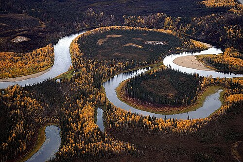
The Banco Convention of 1905 between the United States and Mexico allowed, in the event of sudden changes in the course of the Rio Grande (as by flooding), for the border to be altered to follow the new course.[557] The sudden changes often created bancos (land surrounded by bends in the river that became segregated from either country by a cutoff, often due to rapid accretion or avulsion of the alluvial channel), especially in the Lower Rio Grande Valley. When these bancos are created, the International Boundary and Water Commission investigates if land previously belonging to the United States or Mexico is to be considered on the other side of the border.[558] In all cases of these adjustments along the Rio Grande under the 1905 convention, which occurred on 37 different dates from 1910 to 1976, the transferred land was minuscule (ranging from 1-acre (4,000 m2) to 646 acres (261 ha)) and uninhabited.[559][560][561]
See also
- List of territorial disputes
- Geography of the United States
- Territories of the United States
- Historic regions of the United States
- American frontier
- List of U.S. state partition proposals
- List of U.S. states by date of admission to the Union
- Movements for the annexation of Canada to the United States
- Manifest destiny
- National Atlas of the United States
- Ostend Manifesto (annexation of Cuba)
- List of territorial claims and designations in Colorado
- Territorial evolution of Arizona
- Territorial evolution of California
- Territorial evolution of Idaho
- Territorial evolution of Montana
- Territorial evolution of Nevada
- Territorial evolution of New Mexico
- Territorial evolution of North Dakota
- Territorial evolution of Oregon
- Territorial evolution of South Dakota
- Territorial evolution of Utah
- Territorial evolution of Washington
- Territorial evolution of Wyoming
- Territories of the United States on stamps
- List of United States treaties § U.S.–Native American treaties
Notes
- ↑Even though there were borders drawn as far as the Mississippi River, the early United States was only settled along the east coast. As the states were surveyed, these lines were solidified, though often missing their intended mark. By the time the country was surveying its western acquisitions in the mid-19th century, the process had improved and was being conducted through the United States General Land Office; the western borders were rarely controversial. Border surveys are given their own entry in this list if they were performed east of the Mississippi River, involved legislation, or were otherwise notable; the rest are detailed in footnotes in the relevant statehood or cession entries.
- ↑The boundaries of the country would be defined in the Treaty of Paris of 1783, with the general claim being everything north of the Floridas, south of Quebec, and east of the Mississippi River.[1]
- ↑The Connecticut General Assembly adopted the name "State of Connecticut" during their session beginning October 10, 1776.[2][3]
- ↑Georgia formally became the "State of Georgia" with the adoption of their constitution on February 5, 1777.[8][9]
- ↑Maryland formally became the "State of Maryland" with the adoption of their constitution around November 11, 1776.[11][12]
- ↑The Massachusetts Bay House of Representatives adopted the name "State of Massachusetts Bay" on December 7, 1776.[14][15]
- ↑New Hampshire formally adopted the name "State of New Hampshire" on September 11, 1776.[17][B]
- ↑New Jersey formally adopted the name "State of New Jersey" on September 20, 1777.[21][C]
- ↑New York formally became the "State of New York" with the adoption of their constitution on April 20, 1777;[24] the New York Provincial Congress adopted the name "Convention of the Representatives of the State of New-York" on July 10, 1776.[25][26]
- ↑North Carolina formally became the "State of North Carolina" with the adoption of their constitution on December 18, 1776.[28][29]
- ↑Pennsylvania was first formally referred to as the "State of Pennsylvania" on July 25, 1776.[31][32]
- ↑Rhode Island formally adopted the name "State of Rhode Island and Providence Plantations" on July 20, 1776.[34][35]
- ↑South Carolina formally became the "State of South Carolina" with the adoption of their constitution on March 19, 1778.[39][40]
- ↑Virginia formally became the "Commonwealth of Virginia" with the adoption of their constitution on June 29, 1776.[42][43]
- ↑Sources disagree on whether the constitution took effect on September 20[50] or September 21.[51]
- ↑Sources disagree on whether this formally occurred on January 15[54] or January 17.[55]
- ↑The New Hampshire towns petitioning to join Vermont were: Apthorp (now Littleton), Bath, Canaan, Cardigan (now Orange), Cornish, Dresden (now part of Hanover), Enfield, Franconia, Gunthwaite (now Lisbon), Haverhill, Landaff, Lebanon, Lyman, Lyme, Orford, and Piermont.[58]
- ↑The New Hampshire towns petitioning to join Vermont were: Acworth, Alstead, Bath, Cardigan (now Orange), Charlestown, Chesterfield, Claremont, Cornish, Croydon, Dorchester, Dresden, Franconia, "Gilsom" (likely Gilsum), Grafton, Grantham, Gunthwaite (now Lisbon), Hanover, Haverhill, Hinsdale, Landaff, Lancaster, Lebanon, "Leinster" (possibly Lempster), Lincoln, Lyman, Lyme, Marlow, Newport, Piermont, Plainfield, Richmond, Saville (now Sunapee), Surry, Walpole, and Westmoreland.[65]
- ↑The New York towns petitioning to join Vermont were: "Black-Creek" (unknown; possibly is or is near Hebron), Cambridge, Fort Edward, Granville, "Greenfield" (unknown; there is a town named Greenfield but it is west of the Hudson River, which was explicitly the western extent of the West Union), Hoosick, Kingsbury, "Little Hoosack" (unknown; presumably near Hoosick), Saratoga, "Scorticook" (possibly Schaghticoke), Skeensborough (now Whitehall), and "Upper-White-Creek" (probably White Creek).[66]
- ↑The Supreme Court noted in 1933 that this occurred on February 22,[E] but a 1823 printing of the Vermont State Papers indicates it was February 23.[69]
- ↑New York made the cession on March 1, 1781, and Congress accepted it on October 29, 1782.[F]
- ↑It is unclear from where this claim came; many sources state that New York had surrendered it, but few elaborate on how it was obtained, beyond some saying it was a cession from the Six Nations.[73][74]
- ↑Virginia made the cession during the session beginning October 20, 1783, and Congress accepted it on March 1, 1784.[G]
- ↑The agreement was made provisionally on August 31, 1779;[80] approved by Virginia on June 23, 1783; and approved by Pennsylvania on April 1, 1784.[81]
- ↑The treaty was signed September 3, 1783, ratified January 14, 1784, and entered into force May 12, 1784.[H]
- ↑The treaty established the boundaries of the new country, from the Bay of Fundy: up the "St. Croix River" (which river this referred to was disputed) to its source; north to the height of the land (the "Northwest Angle of Nova Scotia"); along the height of the land to the "northwesternmost Head" of the Connecticut River (which source this referred to was disputed); down that to 45° north; west to the St. Lawrence River; up that to the Great Lakes, through Lake Ontario, the Niagara River, Lake Erie, the Detroit River, Lake St. Clair, the St. Clair River, Lake Huron, and Lake Superior; to "Long Lake" (which lake this referred to was disputed) towards the Lake of the Woods; to the northwest angle of the Lake of the Woods; then west to the Mississippi River. However, the Lake of the Woods was north of the source of the Mississippi River; maps universally show this undefined boundary as a straight line, nearly straight south, between the two points. From there, it followed the Mississippi River down to 31° north; east to the Chattahoochee River; down that to the confluence of the Chattahoochee and Flint rivers; a line from there to the source of the St. Mary's River; then down that to the Atlantic Ocean.[H]
- ↑All sources show Georgia enlarging to fill the new borders,[86] but an act in 1798 referred to the federal and Georgia governments having "interfering claims" over the region.[I]
- ↑There is some confusion over if the state was named Franklin or Frankland, complicated by another attempt at a state in the region using the name Frankland.[88]
- ↑Massachusetts made the cession on November 13, 1784, and Congress accepted it on April 19, 1785.[K]
- ↑Massachusetts' ceded claim was a strip west of New York and Pennsylvania stretching to the Mississippi River, bounded by the latitudes of Massachusetts Bay Colony's original charter: on the north by a line west from one league north of Lake Winnipesaukee, and on the south by a line west from Massachusetts' southwest corner.[74]
- ↑Connecticut made the cession on May 11, 1786, and Congress accepted it on September 14, 1786.[L]
- ↑Connecticut's ceded claim was a strip west of 120 miles west of Pennsylvania (the western border of its Western Reserve) stretching to the Mississippi River, bounded by 41° north and the southern edge of Massachusetts' western claim, roughly 42°2′ north.[74]
- 12345678910This is the date used to consider the border as formally surveyed, as no dates of government approval are known.
- ↑Massachusetts noted in a resolve passed on November 21, 1787, that the surveyors agreed on their report on July 21, 1787.[O]
- ↑South Carolina made the cession on March 8, 1787,[P] and Congress accepted it on August 9, 1787.[Q]
- ↑No date of approval by New York is known.
- ↑North Carolina made the cession on December 22, 1789,[74] and the federal government accepted it on April 2, 1790.[T]
- ↑Surveyor Andrew Ellicott wrote several letters on October 11, 1790, referring to his work having been completed the previous day,[113][114] but no dates of government approval are known.
- ↑Vermont ratified the United States Constitution on January 10, 1791.[115]
- ↑The New York–Vermont border was Lake Champlain, the Poultney River, then south following borders of townships.[116]
- ↑The district did not have a formal name; in September 1791, the commissioners in charge of planning the city would term it the "Territory of Columbia".[117]
- ↑Maryland made the cession on December 23, 1788,[X] and, after the district's borders were set, formally ceded the specific parcel on December 19, 1791.[Y] Virginia made the cession on December 3, 1789.[120]
- ↑The act approving the sale was approved on January 3, 1792.[Z] President George Washington presented the deed to Pennsylvania on March 3, 1792,[122] and most sources use this date for the formal transfer;[52][123] however, some use April 23.[124][125]
- ↑Virginia agreed to cede the territory to the federal government on December 18, 1789.[AA]
- ↑The new Kentucky–Virginia border was, from the south: north along the Cumberland Mountains and Pine Mountain to the Russell Fork; northeast to the Tug Fork; then down that to the Big Sandy River and to the Ohio River.[126]
- ↑The treaty was signed October 27, 1795, ratified March 7, 1796, and entered into force April 25, 1796.[AC]
- ↑No date of approval by Kentucky is known.
- ↑Surveyor Andrew Ellicott wrote, "The reports with the maps... being completed on the 10th of April;"[140] no dates of government approval are known.
- ↑The act accepting the cession was approved on April 28, 1800,[AF] and Connecticut approved on May 30, 1800.[142]
- ↑The new Indiana Territory–Northwest Territory border was a line from the mouth of the Kentucky River to Fort Recovery, then north.[143]
- ↑Georgia's commissioners agreed to cede the region on April 24, 1802, and the legislature approved on June 16, 1802.[AI]
- ↑The new Georgia–federal border was: up the Chattahoochee River to its great bend (near West Point), then a line from there towards and past Nickajack until it reached the Tennessee River, and up that to Tennessee.[146]
- ↑On February 19, 1803, the president signed an act approving Ohio's boundaries and constitution;[AJ] however, Congress never passed a formal resolution admitting it as a state. When this was noticed in 1953, Congress retroactively set the date of statehood to March 1, 1803,[AK] the date the state legislature first met.[147]
- ↑The western border of Ohio had been surveyed in 1799 as far north as Fort Recovery.[148]
- ↑The survey was approved by Virginia on January 22, 1803, and by Tennessee on November 3, 1803.[AM]
- ↑The final report of the commissioners was delivered on November 30, 1803;[155] no dates of government approval are known.
- ↑The treaty was signed April 30, and ratified and entered into force October 21, 1803.[AN] The formal turnover occurred in New Orleans on December 20, 1803,[158] and would be recognized in St. Louis in Upper Louisiana on March 10, 1804, which would be known as known as Three Flags Day.[159]
- ↑There was some question as to whether the purchase also included the basins of the Missouri River and the Red River of the North,[161] but the question was not relevant before the Treaty of 1818 definitively settled the border.
- ↑The western border of West Florida was a series of waterways, mainly the Mississippi, Iberville, and Amite Rivers, and Lakes Pontchartrain and Maurepas.[162]
- ↑The new Illinois Territory–Indiana Territory border was, up the Wabash River to Post Vincennes, then north.[166]
- ↑The northern border of Louisiana had been surveyed in 1806.[171]
- ↑The cession was approved by the federal government on April 14, 1812,[AV] and accepted by Louisiana on August 4, 1812.[AW]
- ↑Indiana was defined as the territory north of the Ohio River and east of the Wabash River, but while the territory's line turned north at Post Vincennes, the state's border continued up the Wabash until it reached the point where a line drawn north from Post Vincennes would last intersect the river as it weaved back and forth. The northern border of the state was a line east from 10 miles north of the southern tip of Lake Michigan, until it reached the meridian that formed Ohio's western border, which was a line drawn north from the mouth of the Great Miami River.[150]
- ↑The new Alabama Territory–Mississippi Territory border was, from the north: up the Tennessee River to Bear Creek (around today's Pickwick Lake); a line to the northwestern corner of Washington County, Mississippi Territory; then south.[171]
- ↑The Kingdom of Great Britainunited with the Kingdom of Ireland on January 1, 1801, becoming the United Kingdom.
- ↑The treaty was signed October 20, 1818, ratified January 28, 1819, and entered into force January 30, 1819.[BC]
- ↑Oregon Country had no defined northern limit; it can be assumed that it did not encroach upon Russian-held lands, and 54°40′ north would be established as the border in 1825.
- ↑The new Arkansaw Territory–Missouri Territory border was, from where the Mississippi River meets 36° north: west to the St. Francis River, up that to 36°30′ north, then west.[185]
- ↑The compact between the states was signed on February 2, 1820; approved by Kentucky on February 11, 1820;[BI] and approved by the federal government on May 12, 1821.[BJ]
- ↑Alabama's southwestern border was defined as a north-south line, but the statehood act called for a survey to confirm if this encroached on counties established by Mississippi; it was found to do so, and the southern terminus of the border was moved about 3.8 miles to the east.[89]
- ↑The treaty was signed February 22, 1819, and ratified and entered into force February 22, 1821.[BK]
- ↑The new border was, from the Gulf of Mexico: up the Sabine River to 32° north; north to the Red River; up that to 100° west; north to the Arkansas River; up that to its source; north to 42° north; then west to the Pacific Ocean.[162]
- ↑The new Missouri–federal border was, from the mouth of the Des Moines River: up the river to a point west of the Des Moines Rapids on the Mississippi River, west to a point north of the mouth of the Kansas River, then south.[174] The northern border had been surveyed in 1816,[202] and the survey of the western border south of the Kansas River would be completed on October 16, 1823.[202][203]
- ↑The survey was approved by North Carolina during the session beginning November 19, 1821;[BM] no date of approval by Tennessee is known.
- ↑The survey was approved by Kentucky on November 13, 1821, and by Tennessee on November 22, 1821.[194]
- ↑The treaty was signed April 17, 1824, ratified January 7, 1825, and entered into force January 11, 1825.[BP]
- ↑The treaty was signed May 6, and ratified May 28, 1828.[BQ]
- ↑The new Arkansas Territory–federal border was, from the north: a line from the southwestern corner of Missouri to a point on the Arkansas River "100 paces east" of Fort Smith, as the border of the lands of the Eastern Choctaw, then south.[185] However, the Arkansas Supreme Court determined in 1909 that the "100 paces east" was a clerical error, and that logically it should have said "100 paces west".[BR] The western border of Arkansas Territory south of Fort Smith had been surveyed in 1825.[210]
- ↑The survey was approved by Maine on February 28, 1829, and by New Hampshire on July 1, 1829.[211]
- ↑The survey was approved by Kentucky on February 9, 1828, and by Tennessee on December 20, 1831.[213]
- ↑Authorities with Indian Stream communicated to the British government on August 5, 1835, that they had accepted New Hampshire jurisdiction;[216] a resolution to this effect was approved by the citizens of Indian Stream on April 2, 1836.[215]
- ↑The western border north of Fort Smith had been surveyed in 1831.[210]
- ↑The northern half of the Indiana–Ohio border was surveyed in 1817 along with the northern border.[152]
- ↑The new Michigan Territory–Wisconsin Territory border was, from Lake Superior: up the Montreal River to Lac Vieux Desert; a line to the source of the Menominee River; then down that to Green Bay. However, this definition was impossible, as the Montreal River ended long before it reached Lac Vieux Desert.[218]
- ↑The cession was approved by the federal government on June 7, 1836,[BY] accepted by Missouri on December 16, 1836,[BZ] and proclaimed by the president on March 28, 1837.[CA]
- ↑No date of approval by Mississippi is known.
- ↑The survey was approved by Georgia on December 8, 1826,[227] and by Alabama on January 27, 1840.[228]
- ↑The treaty was signed August 9, ratified August 22, and entered into force October 13, 1842.[CF]
- ↑The new northeastern border was, from Passamaquoddy Bay: up the St. Croix River to its source; north to the St. John River; up that to the St. Francis River; up that to its source outlet at Lake Pohenegamook; southwest to the northwest branch of the St. John River; a line from there to where the St. John River crosses 46°25′ north; up the river to its source; along the highlands to the source of Halls Stream, then down that to 45° north.[231]
- ↑The new northern border was, from Lake Superior: up the Pigeon River to the many lakes and rivers of the Boundary Waters, eventually reaching the Rainy River; then down that to the Lake of the Woods.[231]
- ↑Texas formally handed over sovereignty to the United States in a ceremony on February 19, 1846.[233]
- ↑While many sources state that Mexico recognized the independence of the eastern portion of Texas, the treaties were rejected by the Mexican government.
- ↑The treaty was signed June 15, ratified June 19, and entered into force July 17, 1846.[CI]
- ↑The survey of the northern border would be completed on August 9, 1852.[237][238]
- ↑The retrocession act was approved on July 9, 1846,[CK] residents of Alexandria County were proclaimed by the president on September 7, 1846, to have agreed to it,[CL] and Virginia took possession on March 20, 1847.[CM]
- ↑Article III of the Treaty of 1908 noted that the survey was completed on June 28, 1847.[CN]
- ↑The new Wisconsin–Wisconsin Territory border was, from Lake Superior: up the St. Louis River to its first rapids; south to the St. Croix River; then down that to the Mississippi River.[242]
- ↑The treaty was signed February 2, ratified March 16, and entered into force May 30, 1848.[CR]
- ↑The new international border was, from the Rio Grande: along the southern and western border of New Mexico until it met the Gila River; down that to the Colorado River; then a line to a point one league south of the port of San Diego. However, the southern border of New Mexico was in question, with the American claim being 31°52′ north, and the Mexican claim being 32°22′ north.[247]
- ↑The federal government consented on July 5, 1848,[CV] and Texas approved on November 24, 1849.[251]
- ↑The new California–federal border was, from the north: south along 120° west to 39° north; a line to where the Colorado River intersects 35° north; then down the Colorado River.[253]
- ↑Part of Utah Territory overlapped with the portion of Texas that would be purchased on December 13, 1850.
- ↑The new Texas–federal border was, from the south: up the Rio Grande to 32° north; east to 103° west; north to 36°30′ north; then east.[257]
- ↑The new New Mexico Territory–federal border was, from 36°30′ north and 103° west: north to 38° north; then west to the summit of the San Juan Mountains (called then the Sierra Madre).[258]
- ↑The treaty was signed December 30, 1853, ratified June 29, 1854, and entered into force June 30, 1854.[DD]
- ↑The new international border was, starting from where the Rio Grande crosses 31°47′ north: west 100 miles; south to 31°20′ north; west to 111° west; a line to a point on the Colorado River 20 miles below the mouth of the Gila River; then up the Colorado River.[267]
- ↑Massachusetts made the cession on May 14, 1853, New York accepted it on July 21, 1853, the federal government consented on January 8, 1855,[DF] and the cession was proclaimed on January 11, 1855.[269]
- ↑The new Minnesota–federal border was, from the north: up the Red River to the Bois de Sioux River; up that to Lake Traverse and its southern tip; a line to Big Stone Lake and through that to its southern tip; then south.[237]
- ↑Haiti claimed the island by name in its 1874 constitution,[DJ] and had considered it included in the "adjacent islands" claimed since the 1801 constitution.[DK]
- ↑The new Oregon–Washington Territory border was, from the north, up the Snake River to the mouth of the Owyhee River, then south.[262] The border with California would be surveyed in 1870.[253]
- ↑The claimed borders of Jefferson Territory were between 37° north, 43° north, 102° west, and 110° west.[282]
- ↑Forty-six islands were claimed on February 8, 1860, with varying degrees of accuracy and provenance:[271]
- The islands that were accurately described and named: Birnie Island, Caroline Island, Flint Island, Gardner Island, Nassau, Palmyra Atoll, Penrhyn, Sydney Island, and Washington Island.
- The islands that were accurately described, with less common names: Atafu (recorded as "Duke of York Island"[284]); Butaritari (recorded as "Mackin or Makin"); Canton Island (recorded as "Mary's Island"[285]); Fanning Island (recorded as "America Islands"[286]); Kingman Reef (recorded as "Danger Rock"[287]); Manihiki (recorded as "Ganges Island" and "Humphrey's Island"[288]); Marakei (recorded as "Mathews Island"[289]); Nukunonu (recorded as "Clarence Island"[290]); Pukapuka (recorded as "Dangerous Islands"[291]); Rakahanga (recorded as "Rierson's Island"[292]); Swains Island (recorded as "Quiros Island"[293]); and Vostok Island (recorded as "Staver's Island"[294]).
- The rest appear to be phantom islands; Sarah Ann Island was sighted in 1917, but has since disappeared.[295]
- Enderbury Island, Phoenix Island, and Starbuck Island were re-bonded to the United States Guano Company, having been bonded to the Phoenix Guano Company on December 27, 1859.[296]
- ↑The northern Kansas border had been surveyed by 1859.[298]
- ↑The borders of Colorado Territory were parallels 37° north and 41° north, and Washington meridians25° west and 32° west.[283]
- ↑The new Nebraska Territory–Dakota Territory border was, from the east: up the Missouri River to the Niobrara River; up that to the Keya Paha River; up that to 43° north; then west.[302]
- ↑The law admitting the state required a presidential proclamation before it was to take effect,[DT] which sources say took place on May 21, 1861;[311] the closest known primary document is a statement from Jefferson Davis on July 20 stating that the proclamation had been made.[312]
- ↑The treaty was signed October 2,[DY] and ratified December 21, 1861.[322]
- ↑The treaty was signed October 4,[DZ] and ratified December 21, 1861.[324]
- ↑The full description of the native party to the treaty was, "the Seneca tribe of Indians, formerly known as the Senecas of Sandusky, and the Shawnees of the tribe or confederacy of Senecas and Shawnees, formerly known as the Senecas and Shawnees of Lewistown, or the mixed bands of Senecas and Shawnees."[325]
- ↑The treaty was signed October 7,[EA] and ratified December 23, 1861.[328]
- ↑The treaty was signed August 1,[EB] and ratified December 23, 1861.[330]
- ↑The treaty was signed July 12,[EC] and ratified December 31, 1861.[332]
- ↑The full description of the native party to the treaty was, "The Pen-e-tegh-ca Band of the Ne-um or Comanches, and the tribes and bands of the Wich-i-tas, Cado-Ha-da-chos, Hue-cos, Ta-hua-ca-ros, A-na-dagh-cos, Ton-ca-wes, Ai-o-nais, Ki-chais, Shawnees and Delawares, residing in the said leased country."[334]
- ↑The full description of the native party to the treaty was, "The No-co-ni, Ta-ne-i-weh, Ya-pa-rih-ca and Co-cho-tih-ca bands of the Ne-um, called by the white men the Comanches of the Prairies and the Staked Plain."[336]
- ↑There were two treaties with the Comanche, one with the "Comanches and other Tribes and Bands"[ED][ds] and one with the "Comanches of the Prairies and Staked Plain."[EE][dt] Both were signed on August 12, 1861, and ratified on December 31, 1861.[337]
- ↑The treaty was signed July 10,[EF], and ratified December 31, 1861.[332]
- ↑The treaty was signed October 4,[EG] and ratified December 31, 1861.[340]
- ↑The decree transferred land from the left bank of the Blackstone River to Rhode Island, including what is now East Providence, in exchange for land around Fall River being transferred to Massachusetts.[341]
- ↑The Restored Government of Virginia gave its consent on May 13, 1862, the act admitting West Virginia was approved on December 31, 1862,[EK] and the president proclaimed on April 20, 1863, that it would become a state in sixty days.[EL]
- ↑The Virginia counties that became West Virginia were: Barbour, Boone, Braxton, Brooke, Cabell, Calhoun, Clay, Doddridge, Fayette, Gilmer, Greenbrier, Hampshire, Hancock, Hardy, Harrison, Jackson, Kanawha, Lewis, Logan, McDowell, Marion, Marshall, Mason, Mercer, Monongalia, Monroe, Morgan, Nicholas, Ohio, Pendleton, Pleasants, Pocahontas, Preston, Putnam, Raleigh, Randolph, Ritchie, Roane, Taylor, Tucker, Tyler, Upshur, Wayne, Webster, Wetzel, Wirt, Wood, and Wyoming.[153]
- ↑The Restored Government of Virginia gave its consent on January 31, 1863,[EM] West Virginia accepted on August 5, 1863,[EN], and the federal government consented after-the-fact on March 10, 1866.[EO]
- ↑The Restored Government of Virginia gave its consent on February 4, 1863,[EP] West Virginia accepted on November 2, 1863,[EQ] and the federal government consented after-the-fact on March 10, 1866.[EO]
- ↑The new Idaho Territory–Montana Territory border was, from the north: south along 39° west from Washington to the crest of the Bitterroot Range and the Rocky Mountains; then along that to the new tripoint with Dakota Territory.[352]
- ↑The new Dakota Territory–Idaho Territory border was, from the south: north along 33° west from Washington to the crest of the Rocky Mountains, then northwest along that to the new tripoint with Montana Territory.[302]
- ↑The northern border with Oregon would be surveyed in 1873 by the General Land Office.[304]
- ↑The cession was approved by the federal government on May 5, 1866;[ET] the receipt of this specific grant was pre-approved in the Nevada constitution.[EU]
- ↑The survey was approved by Florida on February 8, 1861,[EW] and by Georgia on December 13, 1866.[EX] The federal government would acknowledge the surveyed border on April 9, 1872.[EY]
- ↑The cession was approved by the federal government on May 5, 1866,[ET] and accepted by Nevada on January 18, 1867.[EZ]
- ↑The survey of the full eastern border would be completed on December 26, 1870.[249][361]
- ↑The treaty was signed March 30, ratified May 28, and entered into force June 20, 1867.[FC] The cession was formally handed over on October 18, 1867.[364]
- ↑The borders of the Department of Alaska were, from the Dixon Entrance: Up the Portland Channel to 56° north; then along the "summit of the mountains situated parallel to the coast" (the definition of which was disputed) to 141° west; then north.[267]
- ↑The readmission was contingent on Florida ratifying the Fourteenth Amendment to the United States Constitution;[FE] they were proclaimed on July 11, 1868, to have done so before the readmission act's passage.[FF]
- ↑The readmission was contingent on North Carolina ratifying the Fourteenth Amendment to the United States Constitution;[FE] they were proclaimed on July 11, 1868, to have done so on July 4, 1868.[FF]
- ↑The readmissions were contingent on the states ratifying the Fourteenth Amendment to the United States Constitution;[FE] they were proclaimed on July 18, 1868, to have done so on July 9, 1868.[FG]
- ↑The readmission was contingent on Alabama ratifying the Fourteenth Amendment to the United States Constitution;[FE] they were proclaimed on July 20, 1868, to have done so on July 13, 1868.[FH]
- ↑The readmission was contingent on Georgia ratifying the Fourteenth Amendment to the United States Constitution;[FE] they were proclaimed on July 27, 1868, to have done so on July 21, 1868.[FI]
- ↑The organic act specified it would take effect after the territorial government was organized;[FJ] while this would not occur until May 19, 1869,[367] all sources use July 25, 1868, as the creation date.
- ↑The borders of Wyoming Territory were parallels 41° north and 45° north, and Washington meridians27° west and 34° west.[368]
- ↑Pedro Cays was bonded under the name "Petrel Island."[373]
- ↑Additional requirements had been made of Georgia to complete Reconstruction, including ratifying the Fifteenth Amendment to the United States Constitution;[FN] having done so, they were readmitted.[FO]
- ↑The cession was approved by the federal government on April 28, 1870,[FP] and accepted by Nebraska on February 9, 1871.[FQ]
- ↑Articles 34 and 35 of the Treaty of Washington[FS] provided for the dispute to be arbitrated by Wilhelm I, who delivered his decision on October 21, 1872.[236]
- ↑The General Land Office surveyed the border with Nebraska in 1869,[263] and with Kansas in 1872.[298]
- ↑Two other islands were bonded on September 13, 1880: "De Anes", with the coordinates of Isla de Aves, but which was acknowledged by the United States in 1859 to belong to Venezuela, so it is assumed nothing ever came of this bond, and no further claim was ever made by the United States;[385] and Serranilla Bank, being bonded a second time.[371]
- ↑The cession was approved by the federal government on March 18, 1882,[FX] and accepted by Nebraska on May 23, 1882.[FY]
- ↑Scorpion Reef was bonded under the name "Alacrans Islands, viz, Perez Island, Chica Island, and Pajoras Island."[370]
- ↑This is the date the protectorate was proclaimed on Rakahanga;[392] Bryan says the islands were annexed on August 9, 1889.[393]
- ↑The General Land Office had surveyed the eastern border with Minnesota in 1860,[237] and the southern border with Nebraska west of the Keya Paha River in 1874;[263] and would survey east of the river in 1893,[263] and the border between the new states in 1892.[302]
- ↑The General Land Office had surveyed the eastern border in 1885.[369]
- ↑The General Land Office had surveyed the southern border in 1864.[262]
- ↑The new Oklahoma Territory–federal border was, from where the Red River meets 98° west: north to the Canadian River; down that to Seminole land; north along that border to the North Canadian River; down that to Creek land; north and east along that border to 96° west; then north. This omits the Cherokee Outlet, whose complex borders separated the main portion of Oklahoma Territory from the former Public Land Strip.[399]
- ↑The General Land Office had surveyed the border with Oregon in 1868;[262] the border with Nevada in 1873;[304] the border with Washington in 1873, though it stopped short by one mile and would be completed in 1908;[400] the eastern border with Wyoming in 1874;[352] and would survey the linear border with Montana in 1899,[401] and the montane border in 1906.[401]
- ↑The General Land Office had surveyed the border with Nebraska in 1869;[263] the southern border in 1873;[352] the western border in 1874;[352] the eastern border in 1877;[264] and the northern border in 1880.[352]
- ↑The ship that proclaimed the protectorates voyaged from May to July 25, 1892;[405] it is unknown what specific date the proclamations occurred on.
- ↑The Oklahoma Organic Act provided that when the "interest of the Cherokee" in the land was extinguished, and proclaimed by the president, then the land would automatically become part of Oklahoma Territory.[GF] This was done via treaty, signed on December 19, 1891,[407] and ratified on March 3, 1893.[GJ] It was proclaimed by the president on August 19, 1893, to take effect on September 16, 1893.[GK]
- ↑The General Land Office had surveyed the border with Idaho in 1871;[410] the east-west border with Wyoming in 1873 and the north-south border in 1874;[352] and the eastern border in 1879.[411]
- ↑The Newlands Resolution to annex Hawaii was approved on July 7, 1898,[GO] and the formal turnover occurred on August 12, 1898.[412]
- ↑The treaty was signed December 10, 1898, ratified February 6, 1899, and entered into force April 11, 1899.[GP]
- ↑The treaty was signed December 2, 1899, ratified February 13, 1900, and entered into force February 16, 1900.[GQ] The chiefs of the two island groups signed their own treaties with the United States, formally ceding themselves: Tutuila on April 17, 1900,[GR] and Manuʻa on July 16, 1904.[GS] The treaties would not be ratified until February 20, 1929.[GT]
- ↑The cession was made by Tennessee on January 28, 1901,[GY] accepted by Virginia on February 9, 1901,[GZ] and approved by the federal government on March 3, 1901.[HA]
- ↑The treaty was signed November 7, 1900, ratified January 30, 1901, and entered into force March 23, 1901.[HB]
- ↑The borders specified in 1898 had excluded these islands; the new treaty simply ceded "any and all islands belonging to the Philippine Archipelago" which Spain controlled at the time.
- ↑The survey was approved by California on March 1, 1901,[HD] and by Nevada on February 27, 1903.[HE]
- ↑The treaty was signed May 22, 1903, ratified June 25, 1904, and entered into force July 1, 1904.[HF] The formal handover occurred on December 10, 1903.[429]
- ↑The treaty was signed November 18, 1903, ratified February 25, 1904, and entered into force February 26, 1904.[HG] The agreement on the boundaries of the zone, signed June 15, 1904, stated that Panama had delivered the zone on May 19, 1904.[432]
- ↑Only the basic borders were defined: a zone extending five miles from the middle of the canal on each side, excluding the cities of Colón and Panama City.[432]
- ↑Notes were exchanged on December 3, 1904, and the agreement became effective on December 12, 1904.[434]
- ↑The General Land Office had surveyed the border with Kansas in 1857,[298] and with Colorado in 1859.[283]
- ↑The treaty was signed May 21, ratified July 13, and entered into force August 20, 1910.[HL]
- ↑No primary documentation has been found; secondary sources indicate this happened on July 7[445][446][447][448] or July 17, 1911.[449][450]
- ↑The General Land Office had surveyed the northern border in 1868,[451] and the border with Oklahoma in 1874.[283]
- ↑The General Land Office had surveyed the eastern border in 1875,[268] and the northern border in 1901.[259]
- ↑The treaty was signed September 2, 1914, ratified January 4, 1915, and entered into force February 11, 1915;[HQ] one contemporary news source says that ownership was formally transferred on May 1, 1915.[454]
- ↑The treaty concretely defined the previous simple borders, with the main changes being: a slice of Canal Zone was ceded to Panama so Panama City would be connected with the rest of the country; the middle island of the Las Tres Hermanas Islands, which marked the edge of Panama City's harbor, was made wholly part of Canal Zone; and Gatun Lake and other surrounding waters were annexed, as well as an area of northwest Colón.[HQ][454]
- ↑The treaty was signed August 5, 1914, ratified June 19, 1916, and entered into force June 22, 1916.[HR]
- ↑The treaty was signed August 4, 1916, ratified January 16, 1917, and entered into force January 17, 1917;[HU] the payment was proclaimed to have been made on March 31, 1917.[HV]
- ↑Water Island was privately owned at the time, and was purchased by the federal government in 1944 for defensive use.[464] It was transferred to the Department of the Interior in 1952, and to local territorial jurisdiction in phases beginning December 12, 1996.[465]
- ↑The cession was approved by Pennsylvania on June 22, 1897;[HX] accepted by Delaware on March 28, 1921;[HY] and approved by the federal government on June 30, 1921.[HZ]
- ↑The treaty was signed April 6, 1914, ratified January 11, 1922, and entered into force March 1, 1922.[IA]
- ↑The treaty was signed February 24, ratified April 9, and entered into force July 17, 1925.[IC]
- ↑The only change to a land border redefined how the border between the Lake of the Woods and the Rocky Mountains should be considered; previously, the border followed the curve of the parallel between each border monument, while the treaty changed this to straight lines between each monument. There was also a change to the border in the Lake of the Woods; a surveying anomaly caused the previous border to intersect itself several times in the lake, creating enclaves of United States water surrounded by Canadian water. The treaty changed the border to use the southernmost intersection as the northwestern point of the Lake of the Woods. Finally, the maritime border in the Bay of Fundy was adjusted.[485]
- ↑The treaty was signed January 2, 1930, ratified February 21, 1930, and entered into force December 13, 1932.[II]
- ↑Malden Island had been mined by the British since the early 1860s,[494] but was apparently never formally annexed; a British ship left a message on the island on August 17, 1936, proclaiming that it "belong[ed] to His Britannic Majesty."[495]
- ↑The treaty was signed March 2, 1936, ratified July 26, 1939, and entered into force July 27, 1939.[IO]
- ↑The provisional agreement was signed on July 4, 1946,[IP] and the final treaty was signed on July 4, 1946, ratified on August 16, 1946, and entered into force on October 22, 1946.[IQ]
- ↑The territory was entrusted by the United Nations on April 2, 1947,[IS] and accepted by the United States on July 18, 1947.[IT]
- ↑The exchange was approved by Kansas on February 22, 1949, by Missouri on December 19, 1949,[IW] and by the federal government on August 3, 1950.[IX]
- ↑The border was approved by Alabama on August 28, 1953,[IZ] by Florida on June 12, 1953,[JA] and by the federal government on May 6, 1954.[JB]
- ↑The cession was accepted by North Dakota on February 4, 1961,[JH] approved by Minnesota on April 10, 1961,[JI] and approved by the federal government on August 25, 1961.[JJ]
- ↑The convention was signed on August 29, 1963, ratified on December 20, 1963, and entered into force on January 14, 1964.[JK]
- ↑The convention was signed on July 14, 1970, ratified on February 26, 1971, and entered into force on April 25, 1971.[JM]
- ↑The treaty was signed November 22, 1971, ratified July 1, 1972, and entered into force September 1, 1972.[JN]
- ↑The minute was signed on May 18, 1977, and approved by the parties on May 26, 1977.[525]
- ↑Other changes included settling the border around the towns of Presidio, Texas, and Hidalgo, Texas, as well as Beaver Island near Roma, Texas.[526]
- ↑The treaty was signed December 16, 1977, and provisionally entered into force January 1, 1978,[528] but has not been ratified.
- ↑The treaty was signed September 7, 1977, ratified June 15, 1978, and entered into force October 1, 1979.[JO]
- ↑The treaty was signed March 28, 1978, ratified October 10, 1980, and entered into force November 24, 1980.[JP]
- ↑The treaty was signed September 8, 1972, ratified August 24, 1981, and entered into force September 17, 1981.[JQ]
- ↑The treaty was signed December 2, 1980, ratified August 16, 1983, and entered into force September 3, 1983.[JS]
- ↑The treaty was signed June 11, 1980, ratified August 16, 1983, and entered into force September 8, 1983.[JT]
- ↑The treaty was signed September 20, 1979, ratified August 16, 1983, and entered into force September 23, 1983.[JU]
- ↑The treaty was signed February 7, 1979, ratified August 16, 1983, and entered into force September 23, 1983.[JV]
- ↑The compact of free association was signed on June 25, 1983, approved on January 14, 1986,[JX] and entered into force on October 21, 1986.[JY]
- ↑The compact of free association was signed on October 1, 1982, approved on January 14, 1986,[JX] and entered into force on November 3, 1986.[JY]
- ↑The covenant was signed on February 15, 1975, approved on March 24, 1976,[JZ] and entered into force on November 3, 1986.[JY]
- ↑The treaty was signed June 1, 1990, and ratified September 16, 1991.[KA] While never ratified by the Soviet Union or its successor state, Russia, the parties agreed to abide by the terms pending entry into force, effective June 15, 1990.[KB]
- ↑The Federal Register mentions an exchange of notes with Japan on July 5, 1994,[KD] but no primary sourcing has been found.
- ↑The compact of free association was signed on January 10, 1986, approved on November 14, 1986,[KE] and entered into force on October 1, 1994.[KF]
- ↑The treaties were signed on November 5, 1993, ratified by the Senate on October 7, 1994,[KH] and entered into force on June 1, 1995.[KI]
- ↑The treaty was signed May 4, 1978, ratified October 23, 1997, and entered into force November 13, 1997.[KJ]
- ↑The treaty was signed June 9, 2000, ratified January 12, 2001, and entered into force January 17, 2001.[KL]
- ↑The minute was signed on November 5, 2009,[548] and approved by the parties on November 24, 2009.[525]
- ↑The treaty was signed May 13, 1997, ratified November 26, 2003, and entered into force October 7, 2014.[KM]
- ↑The treaty was signed August 1, 2014, ratified March 27, 2019, and entered into force July 18, 2019.[KN]
- ↑The treaty was signed September 6, 2013, ratified March 27, 2019, and entered into force July 19, 2019.[KO]
References
Legal citations
- ↑United States Declaration of Independence, 1 Stat. 1
- ↑An act to adopt and take the name, stile, and title of State, in liew of Colony, in New Hampshire, 1776 N.H. Laws chp. 1, p. 37[18]
- ↑An act to ascertain the punishment for high treason, and to establish the word State instead of Colony in commissions, writs, and other process; and for other purposes therein mentioned, 1777 N.J. Laws chp. 41, p. 92[22]
- ↑An act repealing an act entitled "An act for the effectual securing to His Majesty the allegiance of his subjects in this his Colony and Dominion of Rhode Island and Providence Plantations;" and altering the form of commissions, of all writs and processes in the courts, and of the oaths prescribed by law, May 1776 R.I. Acts & Resolves p. 22[38]
- ↑Vermont v. New Hampshire,289U.S.593, 611(1933)
- ↑JCC 23:694[70]
- ↑JCC 26:112–117[78]
- 12Definitive Treaty of Peace, with Great Britain, T.S. 104,[84] 8 Stat. 80
- 12An act for an amicable settlement of limits with the State of Georgia, and authorizing the establishment of a government in the Mississippi Territory, Pub. L. 5–28, 1 Stat. 549
- ↑JCC 28:381–383[92]
- ↑JCC 28:280–283[93]
- ↑JCC 31:654–655[94]
- ↑Agreement entered into by the commissioners, appointed to settle the controversy between the Commonwealth of Massachusetts and the State of New York, respecting lands lying westward of Hudson's River, Jan. 1786 Mass. Acts pp. 460–467[99]
- ↑An ordinance for the government of the territory of the United States North West of the river Ohio, JCC 32:334[101]
- ↑Resolve directing the secretary to record the agreement entered into by the agents of this commonwealth, and the State of New-York, Oct. 1787 Mass. Acts chp. 101, p. 794[102]
- ↑An act to authorize the delegates of this state in Congress to convey to the United States in Congress assembled, all the rights of this state to the territory herein described, 1787 S.C. Acts no. 1346, p. 5[103]
- ↑JCC 33:466–477[104]
- ↑An act to provide for the government of the Territory Northwest of the river Ohio, Pub. L. 1–8, 1 Stat. 50
- ↑An act to establish and confirm the boundary line between this state and the State of New-York, 1789 Pa. Laws chp. 76, p. 177[111]
- ↑An act to accept a cession of the claims of the state of North Carolina to a certain district of western territory, Pub. L. 1–6, 1 Stat. 106
- ↑An act for the government of the territory of the United States, south of the river Ohio, Pub. L. 1–14, 1 Stat. 123
- 12
- ↑An act for the admission of the State of Vermont into this Union, Pub. L. 1–10, 1 Stat. 191
- ↑An act to cede to Congress a district of ten miles square in this state for the seat of the government of the United States, Nov. 1788 Md. Laws chp. 46, p. 1516[118]
- ↑An act concerning the Territory of Columbia and the City of Washington, Nov. 1791 Md. Laws chp. 45, p. 1633[119]
- ↑An act for carrying into effect a contract between the United States and the State of Pennsylvania, Pub. L. 2–4, 1 Stat. 229
- ↑Compact and boundary with Kentucky, Va. Code § 1-307
- ↑An act declaring the consent of Congress, that a new state be formed within the jurisdiction of the Commonwealth of Virginia, and admitted into this Union, by the name of the State of Kentucky, Pub. L. 1–4, 1 Stat. 189
- ↑Pinckney's Treaty, with Spain, T.S. 325,[131] 8 Stat. 138
- ↑An act for the admission of the State of Tennessee into the Union, Pub. L. 4–47, 1 Stat. 491
- ↑An act for confirming and establishing the boundary line between this state and the State of Kentucky, ascertained and fixed by certain commissioners appointed by both states, and for other purposes, Dec. 1779 Va. Acts chp. 46, p. 234[139]
- ↑An act to authorize the President of the United States to accept, for the United States, a cession of jurisdiction of the territory west of Pennsylvania, commonly called the Western Reserve of Connecticut, Pub. L. 6–38, 2 Stat. 56
- ↑An act to divide the territory of the United States northwest of the Ohio, into two separate governments, Pub. L. 6–41, 2 Stat. 58
- ↑An act concerning the District of Columbia, Pub. L. 6–15, 2 Stat. 103
- ↑An act to ratify and confirm certain articles of agreement and cession entered into on the 24th day of April, 1802, between the commissioners of the State of Georgia on the one part, and the commissioners of the United States on the other part, 1802 Ga. Laws, no. 35, p. 48[145]
- ↑An act to provide for the due execution of the laws of the United States, within the State of Ohio, Pub. L. 7–7, 2 Stat. 201
- ↑Joint Resolution for admitting the State of Ohio into the Union, Pub. L. 83–204, 67 Stat. 407
- ↑An act to enable the people of the eastern division of the territory northwest of the river Ohio to form a constitution and state government, and for the admission of such state into the Union, on an equal footing with the original States, and for other purposes, Pub. L. 7–40, 2 Stat. 173
- ↑Virginia v. Tennessee,148U.S.503, 517(1893)
- ↑Treaty for the Cession of Louisiana, with France, T.S. 86,[157] 8 Stat. 200
- ↑An act supplementary to the act intituled "An act regulating the grants of land, and providing for the disposal of the lands of the United States, south of the State of Tennessee," Pub. L. 8–61, 2 Stat. 303
- ↑An act erecting Louisiana into two territories, and providing for the temporary government thereof, Pub. L. 8–38, 2 Stat. 283
- ↑An act to divide the Indiana Territory into two separate governments, Pub. L. 8–5, 2 Stat. 309
- ↑An act further providing for the government of the District of Louisiana, Pub. L. 8–31, 2 Stat. 331
- ↑An act for dividing the Indiana Territory into two separate governments, Pub. L. 10–13, 2 Stat. 514
- ↑
- An act to enable the people of the Territory of Orleans to form a constitution and state government, and for the admission of such state into the Union, on an equal footing with the original states, and for other purposes, Pub. L. 11–21, 2 Stat. 641;
- An act for the admission of the State of Louisiana into the Union, and to extend the laws of the United States to the said state, Pub. L. 12–50, 2 Stat. 701
- ↑An act to enlarge the boundaries of the Mississippi Territory, Pub. L. 12–84, 2 Stat. 734
- ↑An act to enlarge the limits of the State of Louisiana, Pub. L. 12–57, 2 Stat. 708
- ↑A resolution giving the assent of the Legislature to an enlargement of the limits of the State of Louisiana, 1812 La. Acts chp. 1, p. 4[173]
- ↑An act providing for the government of the Territory of Missouri, Pub. L. 12–95, 2 Stat. 743
- ↑
- ↑An act to establish a separate territorial government for the eastern part of the Mississippi Territory, Pub. L. 14–59, 3 Stat. 371
- ↑
- An act to enable the people of the western part of the Mississippi Territory to form a constitution and state government, and for the admission of such state into the union, on an equal footing with the original states, Pub. L. 14–23, 3 Stat. 348;
- Resolution for the admission of the State of Mississippi into the Union, 3 Stat. 472
- ↑
- An act to enable the people of the Illinois Territory to form a constitution and state government, and for the admission of such state into the Union on an equal footing with the original states, Pub. L. 15–67, 3 Stat. 428;
- Resolution declaring the admission of the State of Illinois into the Union, 3 Stat. 536
- ↑Convention on Fisheries, Boundary, and Restoration of Slaves, with the United Kingdom, T.S. 112,[183] 8 Stat. 248
- ↑An act establishing a separate territorial government in the southern part of the Territory of Missouri, Pub. L. 15–49, 3 Stat. 493
- ↑An act ratifying and confirming the line run and marked by commissioners between the States of Tennessee and Georgia, in the year 1818, 1819 Tenn. Acts chp. 18, p. 475[188]
- ↑
- An act to enable the people of the Alabama Territory to form a constitution and state government, and for the admission of such state into the Union on an equal footing with the original states, Pub. L. 15–47, 3 Stat. 489;
- Resolution declaring the admission of the State of Alabama into the Union, 3 Stat. 608
- ↑An act for the admission of the State of Maine into the Union, Pub. L. 16–19, 3 Stat. 544
- ↑An act relative to the Arkansas Territory, Pub. L. 16–48, 3 Stat. 565
- ↑An act to ratify and confirm the adjustment of the boundary line between this state and the State of Tennessee, according to the articles of stipulation entered into by the commissioners appointed by both states, 1819 Ky. Acts chp. 546, p. 922–923[192]
- ↑Resolution giving the consent of Congress to a compact concluded between the States of Kentucky and Tennessee, for the settlement of their boundary line, 3 Stat. 609
- ↑Treaty of Amity, Settlement, and Limits, with Spain, T.S. 327,[198] 8 Stat. 252
- ↑
- An act to authorize the people of the Missouri Territory to form a constitution and state government, and for the admission of such state into the Union on an equal footing with the original states, and to prohibit slavery in certain territories, Pub. L. 16–22, 3 Stat. 545;
- Resolution providing for the admission of the State of Missouri into the Union, on a certain condition, 3 Stat. 645;
- Proclamation admitting Missouri as a State, 3 Stat. 797
- ↑An act to confirm the boundary line between this state and the State of Tennessee, and for other purposes, 1821 N.C. Acts chp. 41, p. 38[205]
- ↑An act for the establishment of a territorial government in Florida, Pub. L. 17–13, 3 Stat. 654
- ↑An act to fix the western boundary line of the Territory of Arkansas, and for other purposes, Pub. L. 18–155, 4 Stat. 40
- ↑Convention on Navigation, Fishing, Trading, and the Northwest Coast of America, with Russia, T.S. 298,[207] 8 Stat. 302
- ↑Treaty with the Western Cherokee, Ratified Indian Treaty 152, 7 Stat. 311
- ↑Bowman v. State, 93 Ark. 168, 129 S.W. 80[209]
- ↑H. Misc. Doc. 53-212, p. 119
- ↑An act to attach the territory of the United States west of the Mississippi river, and north of the state of Missouri, to the Territory of Michigan, Pub. L. 23–98, 4 Stat. 701
- ↑An act for the admission of the State of Arkansas into the Union, and to provide for the due execution of the laws of the United States, within the same, and for other purposes, Pub. L. 24–100, 5 Stat. 50
- ↑An act to settle and establish the northern boundary line of the State of Ohio, Pub. L. 24–117, 5 Stat. 56
- ↑An act establishing the territorial government of Wisconsin, Pub. L. 24–54, 5 Stat. 10
- ↑
- An act to establish the northern boundary line of the State of Ohio, and to provide for the admission of the State of Michigan into the Union upon the conditions therein expressed, Pub. L. 24–99, 5 Stat. 49;
- An act to admit the State of Michigan into the Union, upon an equal footing with the original states, Pub. L. 24–6, 5 Stat. 144
- ↑An act to extend the western boundary of the State of Missouri to the Missouri River, Pub. L. 24–86, 5 Stat. 34
- ↑Missouri v. Kansas,213U.S.78, 84(1909)
- ↑Proclamation issued by the President of the United States, under the act of June 7, 1836, chap. 86, 5 Stat. 802
- ↑1837 Tenn. Priv. Acts chp. 7[224]
- ↑An act to divide the Territory of Wisconsin and to establish the territorial government of Iowa, Pub. L. 25–96, 5 Stat. 235
- ↑S. Doc. 26-4, p. 3
- ↑H. Doc. 27-52, p. 78
- ↑Webster–Ashburton Treaty, with the United Kingdom, T.S. 119,[230] 8 Stat. 572
- ↑An act for the admission of the States of Iowa and Florida into the Union, Pub. L. 28–48, 5 Stat. 742
- ↑
- ↑Oregon Treaty, with the United Kingdom, T.S. 120,[235] 9 Stat. 869
- ↑An act for the admission of the State of Iowa into the Union, Pub. L. 29–1, 9 Stat. 117
- ↑An act to retrocede the County of Alexandria, in the District of Columbia, to the State of Virginia, Pub. L. 29–35, 9 Stat. 35
- ↑Proclamation declaring Alexandria County to be retroceded to Virginia, 9 Stat. 1000
- ↑An act to extend the jurisdiction of the Commonwealth of Virginia over the County of Alexandria, 1847 Va. Acts chp. 53, p. 41[239]
- 123Treaty on the Canadian Boundary, with the United Kingdom, T.S. 497,[241] 35 Stat. 2003
- ↑S. Ex. Docs. 30th Cong., 1st sess., volume 2, Serial Set 504, pp. 73-75
- ↑An act to confirm the boundary line between Missouri and Arkansas, Pub. L. 30–10, 9 Stat. 211
- ↑
- ↑Treaty of Guadalupe Hidalgo, with Mexico, T.S. 207,[246] 9 Stat. 922
- ↑An act to establish the territorial government of Oregon, Pub. L. 30–177, 9 Stat. 323
- ↑Missouri v. Iowa,48U.S.660(1849)
- ↑An act to establish the territorial government of Minnesota, Pub. L. 30–121, 9 Stat. 403
- ↑An act giving the consent of the government of the United States to the State of Texas to extend her eastern boundary, so as to include within her limits one half of Sabine Pass, Sabine Lake, and Sabine River, as far north as the thirty-second degree of north latitude, Pub. L. 30–94, 9 Stat. 245
- ↑United States v. Louisiana,394U.S.1, F2(1969)
- ↑An act for the admission of the State of California into the Union, Pub. L. 31–50, 9 Stat. 452
- ↑An act to establish a territorial government for Utah, Pub. L. 31–51, 9 Stat. 453
- ↑
- An act proposing to the State of Texas the establishment of her northern and western boundaries, the relinquishment by the said state of all territory claimed by her exterior to said boundaires, and of all her claims upon the United States, and to establish a territorial government for New Mexico, Pub. L. 31–49, 9 Stat. 446;
- Proclamation declaring Act of 1850, ch. 49, respecting the boundaries of Texas, to be in force, 9 Stat. 1005
- ↑Missouri v. Iowa,51U.S.1(1850)
- ↑An act to establish the territorial government of Washington, Pub. L. 32–90, 10 Stat. 172
- ↑An act to organize the Territories of Nebraska and Kansas, Pub. L. 33–59, 10 Stat. 277
- ↑Gadsden Treaty, with Mexico, T.S. 208,[266] 10 Stat. 1031
- ↑An act declaring the southern boundary of New Mexico, Pub. L. 33–245, 10 Stat. 575
- ↑An act giving the consent of Congress to the cession by the State of Massachusetts to the State of New York, of the district of Boston Corner, Pub. L. 33–20, 10 Stat. 602
- ↑Florida v. Georgia,58U.S.478, 480(1854)
- ↑H. Ex. Doc. 34-135
- ↑
- An act to authorize the people of the Territory of Minnesota to form a constitution and state government, preparatory to their admission in the union on an equal Footing with the original states, Pub. L. 34–60, 11 Stat. 166;
- An act for the admission of the State of Minnesota into the Union, Pub. L. 35–31, 11 Stat. 285
- ↑1874 Haiti Constitution, art. 2[275]
- ↑1801 Haiti Constitution, art. 1[276]
- ↑An act for the admission of Oregon into the Union, Pub. L. 35–33, 11 Stat. 383
- ↑An act for the admission of Kansas into the Union, Pub. L. 36–20, 12 Stat. 126
- ↑An act to provide a temporary government for the Territory of Colorado, Pub. L. 36–59, 12 Stat. 172
- ↑An act to admit Texas as a member of the Confederate States of America, Provisional Confederate Cong., sess. 1, chp. 24, p. 44[301]
- ↑An act to provide a temporary government for the Territory of Dakota, and to create the Office of Surveyor General therein, Pub. L. 36–86, 12 Stat. 239
- ↑An act to organize the Territory of Nevada, Pub. L. 36–83, 12 Stat. 209
- ↑An act to admit the Commonwealth of Virginia as a member of the Confederate States of America, Provisional Confederate Cong., sess. 2, chp. 4, p. 104[306]
- ↑An act to admit the State of Arkansas into the Confederacy, Provisional Confederate Cong., sess. 2, chp. 30, p. 120[307]
- ↑An act to admit the State of North Carolina into the Confederacy, on a certain condition, Provisional Confederate Cong., sess. 2, chp. 25, p. 118[310]
- ↑
- ↑Resolution in relation to the withdrawal of Confederate troops from Kentucky soil, 1861 Ky. Acts Res. 8, p. 110[318]
- ↑An act to admit the State of Missouri into the Confederacy, as a member of the Confederate States of America, Provisional Confederate Cong., sess. 5, chp. 1, p. 221[319]
- ↑An act for the admission of the State of Kentucky into the Confederate States of America, as a member thereof, Provisional Confederate Cong., sess. 5, chp. 5, p. 222[320]
- ↑Treaty with the Osages, signed October 2, 1861[321]
- ↑Treaty with the Senecas and Senecas and Shawnees, signed October 4, 1861[323]
- ↑Treaty with the Cherokees, signed October 7, 1861[327]
- ↑Treaty with the Seminole Nation, signed August 1, 1861[329]
- ↑Treaty with Choctaws and Chickasaws, signed July 12, 1861[331]
- ↑Treaty with the Comanches and other Tribes and Bands, signed August 12, 1861[333]
- ↑Treaty with the Comanches of the Prairies and Staked Plain, signed August 12, 1861[335]
- ↑Treaty with the Creek Nation, signed July 10, 1861[338]
- ↑Treaty with the Quapaws, signed October 4, 1861[339]
- ↑An act to extend the territorial Limits of the Territory of Nevada, Pub. L. 37–173, 12 Stat. 575
- ↑An act to provide a temporary government for the Territory of Arizona, and for other purposes, Pub. L. 37–56, 12 Stat. 664
- ↑An act to provide a temporary government for the Territory of Idaho, Pub. L. 37–117, 12 Stat. 808
- ↑An act for the admission of the State of "West Virginia" into the Union, and for other purposes, Pub. L. 37–6, 12 Stat. 633
- ↑Proclamation admitting West Virginia as a State, 13 Stat. 731
- ↑An act giving the consent of the State of Virginia to the County of Berkeley being admitted into and becoming part of the State of West Virginia, Restored 1862 Va. Acts, Dec. sess., chp. 54, p. 38[348]
- ↑An act admitting the County of Berkeley into, and making the same part of, this state, 1863 W.V. Acts chp. 35, p. 33[349]
- 12Joint Resolution giving the consent of Congress to the transfer of the Counties of Berkeley and Jefferson to the State of West Virginia, H.J. Res 12, 14 Stat. 350
- ↑An act giving consent to the admission of certain counties into the new State of West Virginia, upon certain conditions, Restored 1862 Va. Acts, Dec. sess., chp. 78, p. 65[350]
- ↑An act admitting the County of Jefferson into, and making the same part of, this state, 1863 W.V. Acts chp. 90, p. 103[351]
- ↑An act to provide a temporary government for the Territory of Montana, Pub. L. 38–95, 13 Stat. 85
- ↑
- 12An act concerning the boundaries of the State of Nevada, Pub. L. 39–73, 14 Stat. 43
- ↑Nev. Const. art. XIV[355]
- ↑Joint Resolution restoring Tennessee to her relations to the Union, 14 Stat. 364
- ↑Resolution relating to the Florida and Georgia boundary line, 1860 Fla. Res. no. 16, p. 237[356]
- ↑Resolution in relation to the Florida boundary line, 1866 Ga. Res. no. 19, p. 221[357]
- ↑An act to settle and quiet the titles to lands along the boundary line between the States of Georgia and Florida, Pub. L. 42–91, 17 Stat. 52
- ↑Joint Resolution in relation to the boundaries of the State of Nevada, and the acceptance of additional territory, ceded by the United States to this State, 1867 Nev. Stat. no. 9, p. 145[360]
- ↑
- An act to enable the people of Nebraska to form a constitution and state government, and for the admission of such state into the Union on an equal footing with the original states, Pub. L. 38–59, 13 Stat. 47;
- An act for the admission of the State of Nebraska into the Union, Pub. L. 39–36, 14 Stat. 391;
- Proclamation admitting Nebraska as a State, 14 Stat. 820
- ↑S. Rept. 40-194, p. 1
- ↑Treaty on the Cession of Alaska, with Russia, T.S. 301,[363] 15 Stat. 539
- ↑An act to admit the State of Arkansas to representation in Congress, Pub. L. 40–69, 15 Stat. 72
- 12345An act to admit the States of North Carolina, South Carolina, Louisiana, Georgia, Alabama, and Florida, to representation in Congress, Pub. L. 40–70, 15 Stat. 73
- 12Proclamation no. 7 readmitting Florida and North Carolina, 15 Stat. 703
- ↑
- ↑Proclamation no. 10 readmitting Alabama, 15 Stat. 705
- ↑Proclamation no. 12 readmitting Georgia, 15 Stat. 708
- ↑An act to provide a temporary government for the Territory of Wyoming, Pub. L. 40–235, 15 Stat. 178
- ↑An act to admit the State of Virginia to representation in the Congress of the United States, Pub. L. 41–10, 16 Stat. 62
- ↑An act to admit the State of Mississippi to representation in the Congress of the United States, Pub. L. 41–19, 16 Stat. 67
- ↑An act to admit the State of Texas to representation in the Congress of the United States, Pub. L. 41–39, 16 Stat. 80
- ↑An act to promote the reconstruction of the State of Georgia, Pub. L. 41–3, 16 Stat. 59
- ↑An act relating to the State of Georgia, Pub. L. 41–299, 16 Stat. 363
- ↑An act to re-define a portion of the boundary line between the State of Nebraska and the Territory of Dakota, Pub. L. 41–64, 16 Stat. 93
- ↑An act to approve an act to re-define a portion of the boundary line between the State of Nebraska, and the Territory of Dakota, 1871 Neb. Laws p. 131–132[375]
- ↑An act to provide a government for the District of Columbia, Pub. L. 41–62, 16 Stat. 419
- ↑Treaty of Amity (Treaty of Washington), T.S. 133,[379] 17 Stat. 863
- ↑An act to readjust the western boundary of Dakota Territory, Pub. L. 42–147, 17 Stat. 464
- ↑
- ↑An act giving the consent of Congress to an agreement or compact entered into between the States of Virginia and Maryland respecting the boundary between said states, Pub. L. 45–196, 20 Stat. 481
- ↑An act giving the consent of Congress to an agreement or compact entered into between the States of New York and Vermont respecting the boundary between said states, Pub. L. 46–49, 21 Stat. 72
- ↑An act to extend the northern boundary of the State of Nebraska, Pub. L. 47–52, 22 Stat. 35
- ↑An act declaring the assent of the State of Nebraska to an act of Congress of the United States, entitled, "An act to extend the northern boundary of the State of Nebraska," approved March 28, 1882, 1882 Neb. Laws chp. 4, p. 56[387]
- ↑Letters Patent, dated March 3, 1882, for the annexation for Morant and Pedro Cays to the Island of Jamaica[388]
- ↑An act providing a civil government for Alaska, Pub. L. 48–53, 23 Stat. 24
- 123An act to provide for the division of Dakota into two states and to enable the people of North Dakota, South Dakota, Montana, and Washington to form constitutions and state governments and to be admitted into the Union on an equal footing with the original states, and to make donations of public lands to such states, Pub. L. 50–180, 25 Stat. 676
- ↑
- ↑Proclamation admitting Montana as a State, 26 Stat. 1551
- ↑Proclamation admitting Washington as a State, 26 Stat. 1552
- 12An act to provide a temporary government for the Territory of Oklahoma, to enlarge the jurisdiction of the United States Court in the Indian Territory, and for other purposes, Pub. L. 51–182, 26 Stat. 81
- ↑An act to provide for the admission of the State of Idaho into the Union, Pub. L. 51–656, 26 Stat. 215
- ↑An act to provide for the admission of the State of Wyoming into the Union, and for other purposes, Pub. L. 51–664, 26 Stat. 222
- ↑
- An act to authorize the President of the United States, in conjunction with the State of Texas, to run and mark the boundary lines between the territories of the United States and the State of Texas, Pub. L. 35–92, 11 Stat. 310;
- An act making appropriations for sundry civil expenses of the government for the fiscal year ending June 30th, 1892, and for other purposes, Pub. L. 51–542, 26 Stat. 971;
- Joint Resolution reaffirming the boundary line between Texas and the Territory of New Mexico, 36 Stat. 1454
- ↑An act making appropriations for current and contingent expenses, and fulfilling treaty stipulations with Indian tribes, for fiscal year ending June 30th, 1894, Pub. L. 52–209, 27 Stat. 640
- ↑Proclamation opening Cherokee Outlet to settlement, 28 Stat. 1222
- ↑
- ↑United States v. Texas,162U.S.1(1896)
- ↑An act to give the consent of Congress to a compact entered into between the States of South Dakota and Nebraska respecting the boundary between said states, Pub. L. 55–12, 30 Stat. 214
- ↑Joint Resolution to provide for annexing the Hawaiian Islands to the United States, 30 Stat. 750
- ↑Treaty of Peace, with Spain, T.S. 343,[415] 30 Stat. 1754
- ↑Convention on Adjustment of Jurisdiction in Samoa, with Germany and the United Kingdom, T.S. 314,[418] 31 Stat. 1878
- ↑Treaty of Cession of Tutuila and Aunuʻu, signed April 17, 1900[419]
- ↑Treaty of Cession of Manu’a Islands, signed July 16, 1904[419]
- ↑Joint Resolution to provide for accepting, ratifying, and confirming the cessions of certain islands of the Samoan group to the United States, and for other purposes, Pub. Res. 70–89, 45 Stat. 1253
- ↑Executive Order no. 125-A, Placing Certain Islands of the Samoan Group Under the Control of the Navy Department, February 19, 1900[419]
- ↑General Order Navy Department no. 540, February 19, 1900[419]
- ↑An act temporarily to provide revenues and a civil government for Porto Rico, and for other purposes, Pub. L. 56–191, 31 Stat. 77
- ↑An act to provide a government for the Territory of Hawaii, Pub. L. 56–339, 31 Stat. 141
- ↑An act to cede to the State of Virginia a certain narrow strip of territory belonging to the State of Tennessee lying between the northern boundary line of the City of Bristol, in the County of Sullivan, and the southern boundary line of the City of Bristol, in the County of Washington, State of Virginia, being the northern half of Main Street, of the said two cities, 1901 Tenn. Acts chp. 85, p. 128[421]
- ↑An act to accept the cession by the State of Tennessee to the State of Virginia, of a certain narrow strip of territory claimed as belonging to the State of Tennessee, and described as lying between the northern boundary line of the City of Bristol, in the County of Sullivan, State of Tennessee, and the southern boundary line of the City of Bristol, in the County of Washington, State of Virginia, being the northern half of the Main Street of the said two cities, 1901 Va. Acts chp. 59, p. 57[422]
- ↑Joint Resolution ratifying agreement between Tennessee and Virginia with reference to the boundary line of said states, 31 Stat. 1465
- ↑Treaty on the Cession of Outlying Islands of the Philippines, with Spain, T.S. 345,[423] 31 Stat. 1942
- ↑An act temporarily to provide for the administration of the affairs of civil government in the Philippine Islands, and for other purposes, Pub. L. 57–235, 32 Stat. 691
- ↑An act to define and establish a portion of the eastern boundary of the State of California, 1901 Cal. Acts chp. 73, p. 89[425]
- ↑An act to define and establish a portion of the western boundary of the State of Nevada, 1903 Nev. Acts chp. 15, p. 38[426]
- ↑Treaty of Relations, with Cuba, T.S. 437,[428] 33 Stat. 2248
- ↑Isthmian Canal Convention, with Panama, T.S. 431,[431] 33 Stat. 2234
- ↑An act to extend the western boundary line of the State of Arkansas, Pub. L. 58–67, 33 Stat. 714
- ↑
- An act to enable the people of Oklahoma and of the Indian Territory to form a constitution and state government and be admitted into the Union on an equal footing with the original states; and to enable the people of New Mexico and of Arizona to form a constitution and state government and be admitted into the Union on an equal footing with the original states, Pub. L. 59–234, 34 Stat. 267;
- Proclamation admitting Oklahoma as a State, 35 Stat. 2160
- 123Michigan v. Wisconsin,270U.S.295(1926)
- ↑Maryland v. West Virginia,217U.S.1(1918)
- ↑Treaty of Boundaries in Passamaquoddy Bay, with the United Kingdom, T.S. 551,[441] 36 Stat. 2477
- 12
- An act to enable the people of New Mexico to form a constitution and state government and be admitted into the Union on an equal footing with the original States; and to enable the people of Arizona to form a constitution and state government and be admitted into the union on an equal footing with the original States, Pub. L. 61–219, 36 Stat. 557;
- Joint Resolution to admit the Territories of New Mexico and Arizona as states into the Union upon an equal footing with the original states, 37 Stat. 39
- ↑Proclamation admitting New Mexico as a State, 37 Stat. 1723
- ↑Proclamation admitting Arizona as a State, 37 Stat. 1728
- ↑An act to create a legislative assembly in the Territory of Alaska, to confer legislative power thereon, and for other purposes, Pub. L. 62–334, 37 Stat. 512
- 12Canal Zone Boundary Convention, with Panama, T.S. 610,[453] 38 Stat. 1893
- ↑Bryan–Chamorro Treaty, with Nicaragua, T.S. 624,[461] 39 Stat. 1661
- ↑An act to declare the purpose of the people of the United States as to the future political status of the people of the Philippine Islands, and to provide a more autonomous government for those islands, Pub. L. 64–240, 39 Stat. 545
- ↑An act to provide a civil government for Porto Rico, and for other purposes, Pub. L. 64–368, 39 Stat. 951
- ↑Treaty of Cession of Danish West Indies, with Denmark, T.S. 629,[463] 39 Stat. 1706
- ↑Proclamation of payment for cession of the Danish West Indies, 40 Stat. 1649
- ↑An act to approve mutual cessions of territory by the States of Wisconsin and Minnesota and the consequent changes in the boundary line between said states, Pub. L. 65–214, 40 Stat. 959
- ↑An act providing for the acceptance, approval and confirmation of the report of the commission appointed in pursuance of the act approved [May 4, 1889], authorizing the examination, survey and re-establishment of the circle of New Castle, as the boundary line between Pennsylvania and Delaware, 1897 Pa. Laws no. 152, p. 182[476]
- ↑An act providing for the acceptance, approval, and confirmation of the report of the commission appointed in pursuance of the act of the General Assembly of the State of Delaware, approved [April 25, 1889], authorizing the examination, survey, and reestablishment of the circle of New Castle as the boundary line between Pennsylvania and Delaware, 1921 Del. Laws chp. 4, p. 7[477]
- ↑Joint Resolution ratifying the reestablishment of the boundary line between the States of Pennsylvania and Delaware, 42 Stat. 104
- ↑Treaty for the settlement of differences arising out of the events which took place on the Isthmus of Panama in November 1903, with Colombia, T.S. 661,[480] 42 Stat. 2122, 9 LNTS 301[481]
- ↑Joint Resolution extending the sovereignty of the United States over Swains Island and making the island a part of American Samoa, 43 Stat. 1357
- ↑Treaty on the Lake Superior–Lake of the Woods Boundary, with Canada, T.S. 720,[484] 44 Stat. 2102
- ↑Michigan v. Wisconsin,272U.S.398(1926)
- ↑New Mexico v. Texas,275U.S.279(1927)
- ↑Oklahoma v. Texas,281U.S.109(1930)
- ↑An act to authorize the modification of the boundary line between the Panama Canal Zone and the Republic of Panama, and for other purposes, Pub. L. 72–117, 47 Stat. 145
- ↑Joint Resolution to change the name of the island of "Porto Rico" to "Puerto Rico", 47 Stat. 158
- ↑Treaty on Boundaries of the Philippines and North Borneo, with the United Kingdom, T.S. 856,[492] 47 Stat. 2198
- ↑
- An act to provide for the complete independence of the Philippine Islands, to provide for the adoption of a constitution and a form of government for the Philippine Islands, and for other purposes, Pub. L. 73–127, 48 Stat. 456;
- Proclamation 2148 on the establishment of the Commonwealth of the Philippines, 49 Stat. 3481
- ↑Wisconsin v. Michigan,297U.S.547(1936)
- ↑Executive Order no. 7368, Placing Certain Islands in the Pacific Ocean Under the Control and Jurisdiction of the Secretary of the Interior[493]
- ↑An act to provide a civil government for the Virgin Islands of the United States, Pub. L. 74–749, 49 Stat. 1807
- ↑Executive Agreement on Joint Administration of Canton and Enderbury Islands, EAS 145,[496] 53 Stat. 2219
- ↑Treaty of Friendship and Cooperation, with Panama, T.S. 945,[497] 53 Stat. 1807
- ↑Provisional Agreement Between the United States of America and the Republic of the Philippines Concerning Friendly Relations and Diplomatic and Consular Representation, TIAS 1539,[503] 60 Stat. 1800
- ↑Treaty of General Relations Between the United States of America and the Republic of the Philippines, TIAS 1568,[504] 61 Stat. 1174
- ↑Proclamation 2695 recognizing the independence of the Philippines, 60 Stat. 1352
- ↑Trusteeship Agreement for the Former Japanese Mandated Islands, TIAS 1665,[505] 61 Stat. 3301
- ↑Joint Resolution authorizing the President to approve the trusteeship agreement for the Territory of the Pacific Islands, Pub. L. 80–204, 61 Stat. 397
- ↑Tokelau Act 1948.
- ↑An act to provide a civil government for Guam, and for other purposes, Pub. L. 81–630, 64 Stat. 384
- ↑An act authorizing the compromising and settling of a controversy between Missouri and Kansas over a part of the boundary between these states, 1949 Mo. Laws chp. 141, p. 311[507]
- ↑Joint Resolution giving the consent of Congress to an agreement between the State of Missouri and the State of Kansas establishing a boundary between said states, Pub. L. 81–637, 64 Stat. 397
- ↑57 FR57093
- ↑An act locating the boundary between the States of Florida and Alabama as defined by the constitution of each respective state, at the mouth of the Perdido River and adjacent thereto, 1953 Ala. Laws no. 440, p. 547[510]
- ↑An act locating the boundary between the States of Florida and Alabama, as defined by the constitutions of each respective state, at the mouth of the Perdido River and adjacent thereto, 1953 Fla. Laws chp. 28141, p. 462[511]
- ↑Joint Resolution giving the consent of Congress to an agreement between the State of Alabama and the State of Florida establishing a boundary between such states, Pub. L. 83–351, 68 Stat. 77
- ↑An act to revise the Organic Act of the Virgin Islands of the United States, Pub. L. 83–517, 68 Stat. 497
- ↑Convention regarding the Colón Corridor and certain other corridors through the Canal Zone, 6 UST 461, TIAS 3180, 241 UNTS 140, I-3430[512]
- ↑Treaty of mutual understanding and co-operation, 12 UST 301, TIAS 4716, 243 UNTS 211, I-3454[514]
- ↑
- ↑
- ↑An act to accept the cession by the State of Minnesota to the State of North Dakota of certain parcels of real property and declaring an emergency, 1961 N.D. Laws chp. 318, p. 517[518]
- ↑An act relating to the cession by the State of Minnesota to the State of North Dakota of certain parcels of real property located in Clay County, Minnesota, 1961 Minn. Laws chp. 236, p. 399[519]
- ↑An act granting the consent of Congress to the compact or agreement between the States of North Dakota and Minnesota with respect to the boundary between such states, Pub. L. 87–162, 75 Stat. 399
- ↑Convention for the Solution of the Problem of the Chamizal, 15 UST 21, TIAS 5515, 505 UNTS 185, I-7374[520]
- ↑Agreement on Availability of Certain Indian Ocean Islands for Defense Purposes, 18 UST 28, TIAS 6196, 603 UNTS 273, I-8737[522]
- ↑Convention terminating the Convention of August 5, 1914, respecting a Nicaraguan canal route, 22 UST 663, TIAS 7120, 791 UNTS 305, I-11243[523]
- ↑Treaty on the Swan Islands, with Honduras, 23 UST 2630, TIAS 7453, 851 UNTS 203, I-12199[524]
- ↑Panama Canal Treaty, with Panama, 33 UST 39, TIAS 10030, 1280 UNTS 3, I-21086[529]
- ↑Maritime Boundary Treaty, with Venezuela, 32 UST 3100, TIAS 9890, 1273 UNTS 25, I-20984[530]
- ↑Treaty Concerning the Status of Quita Sueño, Roncador, and Serrana, with Colombia, 33 UST 1405, TIAS 10120, 1307 UNTS 379, I-21801[531]
- ↑Proclamation 5030: Exclusive Economic Zone of the United States of America, 97 Stat. 1557
- ↑Treaty on the Delimitation of the Maritime Boundary with Tokelau, with New Zealand, 35 UST 2073, TIAS 10775, 1643 UNTS 251, I-28231[533]
- ↑Treaty on Friendship and Delimitation of the Maritime Boundary, with the Cook Islands, 35 UST 2061, TIAS 10774, 1676 UNTS 223, I-28971[534]
- ↑Treaty of Friendship, with Kiribati, 35 UST 2095, TIAS 10777, 1643 UNTS 239, I-28230[535]
- ↑Treaty of Friendship, with Tuvalu, 35 UST 2087, TIAS 10776, 2011 UNTS 79, I-34500[536]
- ↑Delimitation of the Maritime Boundary in the Gulf of Maine Area, 1984 I.C.J. 246[537]
- 12Compact of Free Association Act of 1985, Pub. L. 99–239, 99 Stat. 1770
- 123Proclamation 5564: Placing into Full Force and Effect the Covenant with the Commonwealth of the Northern Mariana Islands, and the Compacts of Free Association with the Federated States of Micronesia and the Republic of the Marshall Islands, 101 Stat. 2027
- ↑Joint Resolution to approve the "Covenant to establish a Commonwealth of the Northern Mariana Islands in political union with the United States of America," and for other purposes, Pub. L. 94–241, 90 Stat. 279
- ↑Agreement on the maritime boundary, with the Soviet Union, Treaty101-22
- ↑Agreement between the United States of America and the Union of Soviet Socialist Republics to abide by the terms of the Maritime Boundary Agreement of 1 June 1990, pending entry into force, UNTS 40300[539]
- ↑United Nations Security Council Resolution 683, UN Doc S/RES/683[540]
- ↑88 FR88482
- ↑Joint Resolution to approve the "Compact of Free Association" between the United States and the Government of Palau, and for other purposes, Pub. L. 99–658, 100 Stat. 3672
- ↑
- Joint Resolution to authorize entry into force of the Compact of Free Association between the United States and the Government of Palau, and for other purposes, Pub. L. 101–219, 103 Stat. 1870;
- Proclamation 6726, placing into full force and effect the Compact of Free Association with the Republic of Palau, 108 Stat. 5631
- ↑United Nations Security Council Resolution 956, UN Doc S/RES/956[541]
- ↑Two treaties with the United Kingdom establishing Caribbean Maritime Boundaries, Treaty103-23
- ↑
- Treaty on the Delimitation in the Caribbean of a Maritime Boundary relating to the U.S. Virgin Islands and Anguilla, 1913 UNTS 59, I-32636[542];
- Treaty on the Delimitation in the Caribbean of a Maritime Boundary relating to Puerto Rico/U.S. Virgin Islands and the British Virgin Islands, 1913 UNTS 67, I-32637[543]
- ↑Treaty on Maritime Boundaries, with Mexico, Treaty96-6, 2143 UNTS 405, I-37399[544]
- ↑New Jersey v. New York,523U.S.767(1998)
- ↑Treaty on the delimination of the continental shelf in the western Gulf of Mexico beyond 200 nautical miles, with Mexico, Treaty106-39, TIAS 01-117,[546] 2143 UNTS 417, I-37400[547]
- ↑Treaty on the Delimitation of a Maritime Boundary, with Niue, Treaty105-53, TIAS 14-1007,[549] 3016 UNTS 305, I-52440[550]
- ↑Treaty on the Delimitation of Maritime Boundaries, with Micronesia, Treaty114-13, TIAS 19-718[553]
- ↑Treaty on the Delimitation of Maritime Boundaries, with Kiribati, Treaty114-13, TIAS 19-719[554]
Books, journals, and websites
- ↑Van Zandt 1976, p. 1.
- ↑"Connecticut: Polity Style: 1776-2025". www.archontology.org. Archived from the original on July 11, 2025. Retrieved December 9, 2025.
- ↑The Public Records of the State of Connecticut, From October, 1776, to February, 1778. Hartford, Connecticut: Charles J. Hoadly. 1894. pp. 1–4.
- ↑Van Zandt 1976, pp. 72–74.
- ↑Van Zandt 1976, pp. 84–85.
- ↑"Delaware: Polity Style: 1682-1776". www.archontology.org. Archived from the original on August 9, 2025. Retrieved December 9, 2025.
- ↑"Delaware Government Facts & Symbols". Government of Delaware. Archived from the original on January 9, 2017. Retrieved October 19, 2025.
- ↑"Georgia: Polity Style: 1776-2025". www.archontology.org. Archived from the original on August 11, 2025. Retrieved December 9, 2025.
- ↑Thorpe 1909b, p. 777.
- ↑Van Zandt 1976, pp. 100–104.
- ↑"Maryland: Polity Style: 1776-2025". www.archontology.org. Archived from the original on August 9, 2025. Retrieved December 9, 2025.
- ↑Thorpe 1909c, p. 1686.
- ↑Van Zandt 1976, pp. 85–88.
- 12"Massachusetts: Polity Style: 1776-2025". www.archontology.org. Archived from the original on August 9, 2025. Retrieved December 9, 2025.
- ↑Journals of the House of Representatives of Massachusetts, 1776-1777. Vol. 52 pt. 2. Boston: Massachusetts Historical Society. 1986. p. 189.
- ↑Van Zandt 1976, pp. 65–71.
- ↑"New Hampshire: Polity Style: 1776-2025". www.archontology.org. Archived from the original on July 11, 2025. Retrieved December 9, 2025.
- ↑Metcalf, Henry Harrison, ed. (1916). Laws of New Hampshire. Vol. 4, Revolutionary Period, 1776–1789. Bristol, New Hampshire: Musgrove Printing House. p. 37.
- ↑Van Zandt 1976, pp. 60–63.
- ↑The Laws of the State of New Hampshire, Enacted since June 1, 1815. Vol. 2. Concord, New Hampshire: Isaac Hill. 1824. pp. 239–240.
- ↑"New Jersey: Polity Style: 1776-2025". www.archontology.org. Archived from the original on December 10, 2025. Retrieved December 10, 2025.
- ↑"New Jersey Session Laws". Rutgers School of Law. Archived from the original on December 21, 2025. Retrieved December 19, 2025.
- ↑Van Zandt 1976, pp. 79–80.
- ↑Thorpe 1909e, p. 2623.
- ↑"New York: Polity Style: 1776-2025". www.archontology.org. Archived from the original on July 11, 2025. Retrieved December 9, 2025.
- ↑Journals of the Provincial Congress, Provincial Convention, Committee of Safety and Council of Safety of the State of New-York, 1775–1776–1777. Vol. 1. Albany, New York: Thurlow Weed. 1842. p. 519.
- ↑Van Zandt 1976, pp. 74–79.
- ↑"North Carolina: Polity Style: 1776-2025". www.archontology.org. Archived from the original on July 13, 2025. Retrieved December 9, 2025.
- ↑Thorpe 1909e, p. 2787.
- ↑Van Zandt 1976, pp. 96–99.
- 12"Pennsylvania: Polity Style: 1776-2025". www.archontology.org. Archived from the original on July 11, 2025. Retrieved December 9, 2025.
- ↑Minutes of the Proceedings of the Convention of the State of Pennsylvania(PDF). p. 761. Archived(PDF) from the original on June 19, 2025.
- ↑Van Zandt 1976, pp. 80–84.
- ↑"Rhode Island: Polity Style: 1776-2025". www.archontology.org. Archived from the original on June 19, 2025. Retrieved December 9, 2025.
- ↑[Acts and Resolves] at the General Assembly of the Governor and Company of the English Colony of Rhode Island and Providence Plantations, January 1776–May 1777. p. 128.
- ↑Van Zandt 1976, pp. 71–72.
- ↑"Rhode Island: Polity Style: 1689-1776". www.archontology.org. Archived from the original on June 19, 2025. Retrieved December 16, 2025.
- ↑"Act of Renunciation, May 4, 1776"(PDF). Secretary of State of Rhode Island. Archived(PDF) from the original on May 24, 2025. Retrieved October 17, 2025.
- ↑"South Carolina: Polity Style: 1776-2025". www.archontology.org. Archived from the original on December 10, 2025. Retrieved December 10, 2025.
- ↑Thorpe 1909f, p. 3248.
- ↑Van Zandt 1976, pp. 99–100.
- ↑"Virginia: Polity Style: 1776-2025". www.archontology.org. Archived from the original on September 6, 2025. Retrieved December 9, 2025.
- ↑Thorpe 1909g, p. 3812.
- ↑Van Zandt 1976, pp. 92–95.
- 123456789101112
- "Nine Capitals of the United States". U.S. Senate. Archived from the original on March 20, 2016. Retrieved March 19, 2016.
- "8 Forgotten Capitals of the United States". History. July 16, 2015. Archived from the original on January 26, 2017. Retrieved October 19, 2025.
- ↑"The North Carolina – South Carolina Border Surveys – 1730 to 1815". Archived from the original on March 4, 2016. Retrieved October 19, 2025.
- ↑Kelly, Stephen R. (August 23, 2014). "How the Carolinas Fixed Their Blurred Lines". The New York Times. Archived from the original on August 31, 2014. Retrieved October 19, 2025.
- ↑Van Zandt 1976, p. 49.
- ↑O'Connor, Joe (November 27, 2012). "Puffin Wars: The island paradise at centre of last Canada-U.S. land dispute". National Post. Retrieved October 19, 2025.
- 12"Delaware: Polity Style: 1776-2025". www.archontology.org. Archived from the original on August 9, 2025. Retrieved December 9, 2025.
- ↑Thorpe 1909a, p. 562.
- 12Van Zandt 1976, p. 84.
- ↑Thorpe 1909e, p. 3081.
- 123Van Zandt 1976, p. 64.
- 12"Vermont: Polity Style: 1777-2025". www.archontology.org. Archived from the original on August 4, 2025. Retrieved December 9, 2025.
- ↑Walton, E.P., ed. (1873). Records of the Council of Safety and Governor and Council of the State of Vermont. Vol. 1. pp. 47–51.
- ↑Vermont 2006 J.R.H. 3, Joint Resolution Designating January as Vermont History and Independence Month, accessed October 19, 2025. Archived October 11, 2006, at the Wayback Machine
- ↑Vermont 1823, p. 89.
- 123Duffy, Hand & Orth 2003, p. 111.
- 1234"The Historical Geography of Vermont". Archived from the original on January 12, 2016. Retrieved January 24, 2016.
- ↑Vermont 1823, p. 90.
- ↑Vermont 1823, pp. 97–99.
- ↑Thorpe 1909c, p. 1922.
- ↑"Articles of Confederation". Avalon Project. Yale Law School. Archived from the original on October 29, 2015. Retrieved October 19, 2025.
- 12Vermont 1823, p. 137.
- ↑Vermont 1823, p. 139.
- ↑Duffy, Hand & Orth 2003, p. 319.
- ↑Vermont 1823, pp. 138–141.
- ↑Vermont 1823, p. 169.
- ↑Hunt 1914, p. 694.
- 12Van Zandt 1976, p. 48.
- ↑Van Zandt 1976, p. 75.
- ↑"Virginia's Cession of the Northwest Territory". Archived from the original on August 17, 2016. Retrieved October 19, 2025.
- 123456Walker 1874, plate XV p. 1.
- 123Van Zandt 1976, pp. 83–84.
- ↑Van Zandt 1976, p. 81.
- ↑Gnichtel, Frederick W. (1921). "The "Pennamite Wars" and the Trenton Decree of 1782". Proceedings of the New Jersey Historical Society. 6: 31.
- ↑Hunt 1928, pp. 112–117.
- 123456Van Zandt 1976, p. 47.
- ↑Paullin 1932, pp. 77–78.
- ↑Brewster, William (1954). The Pennsylvania and New York frontier: history of from 1720 to the close of the Revolution. Philadelphia: George S. MacManus Company. p. 146.
- 12Van Zandt 1976, p. 83.
- ↑Crumrine, Boyd (1902). "Boundary Controversy between Pennsylvania and Virginia; 1748–1785". Annals of Carnegie Museum. 1 (4): 505–568. Bibcode:1902AnCM....1..505C. doi:10.5962/p.331066. S2CID 251488742.
- ↑Bevans 1974b, p. 8.
- ↑Van Zandt 1976, pp. 10–12.
- 12"Boundaries of Georgia". New Georgia Encyclopedia. Archived from the original on August 4, 2025. Retrieved October 19, 2025.
- ↑Van Zandt 1976, pp. 23–24.
- ↑McGill, J. T. (1925). "Franklin and Frankland: Names and Boundaries". Tennessee Historical Magazine. 8 (4): 248–257. ISSN 2333-9012. JSTOR 42637503.
- 12345Van Zandt 1976, p. 109.
- ↑Williams 1924, pp. 29–30.
- ↑Alden, George Henry (1903). "The State of Franklin". The American Historical Review. 8 (2): 273. doi:10.2307/1832926. ISSN 0002-8762. JSTOR 1832926.
- ↑Fitzpatrick 1933, pp. 381–383.
- ↑Fitzpatrick 1933, pp. 280–283.
- ↑Fitzpatrick 1934, pp. 654–655.
- ↑Hicks, Frederick Charles, ed. (1904). A topographical description of Virginia, Pennsylvania, Maryland, and North Carolina. Cleveland: The Burrows Brothers Company. p. 34.
- ↑Hazard, Samuel, ed. (1855). Pennsylvania Archives. Vol. 11. Philadelphia: Joseph Severns & Co. p. 69.
- 123Van Zandt 1976, p. 70.
- ↑Walker 1874, plate XV p. 5.
- ↑Acts and Laws of the Commonwealth of Massachusetts, 1786–87. Boston: Wright & Potter Printing Company. 1893. pp. 460–467.
- ↑Van Zandt 1976, pp. 49–50.
- ↑Hill 1936a, p. 334.
- ↑Acts and Laws of the Commonwealth of Massachusetts, 1786–87. Boston: Wright & Potter Printing Company. 1893. p. 794.
- ↑Cooper, Thomas, ed. (1839). The Statutes at Large of South Carolina, volume 5, 1786–1814. Columbia, South Carolina: A.S. Johnston. p. 5.
- ↑Hill 1936b, pp. 466–477.
- 12Van Zandt 1976, p. 100.
- ↑Cotterill, R. S. (1925). "The South Carolina Land Cession". The Mississippi Valley Historical Review. 12 (3): 376–384. doi:10.2307/1889567. ISSN 0161-391X. JSTOR 1889567.
- 12345678910111213Admission of States to the Union: A Historical Reference Guide (Report). Congressional Research Service. December 17, 2024. CRS Report no. R47747. Retrieved January 3, 2026.
- ↑Williams 1924, p. 225.
- 12Van Zandt 1976, p. 78.
- ↑Clarke 1886, p. 98.
- ↑Laws of the Thirteenth General Assembly of the Commonwealth of Pennsylvania. Philadelphia: T. Bradford. 1789. p. 177. Archived from the original on July 29, 2024. Retrieved December 20, 2025.
- ↑Van Zandt 1976, pp. 50–51.
- ↑Clarke 1886, pp. 450–451.
- ↑Mathews 1908, p. 77.
- ↑Walton, E.P., ed. (1875). Records of the Governor and Council of the State of Vermont. Vol. 3. Montpelier, Vermont: J. & J. Poland. pp. 480–481.
- 12Van Zandt 1976, pp. 64–65.
- ↑Tindall, William (February 25, 1919). "Naming the Seat of Government of the United States: A Legislative Paradox". Records of the Columbia Historical Society. 23. Historical Society of Washington, D.C.: 13. JSTOR 40067136.
- ↑Kilty, William, ed. (1799). The Laws of Maryland, vol. 1. Annapolis, Maryland: Frederick Green. p. 1516. Archived from the original on December 12, 2025. Retrieved December 20, 2025.
- ↑Kilty, William, ed. (1799). The Laws of Maryland, vol. 1. Annapolis, Maryland: Frederick Green. p. 1633. Archived from the original on December 21, 2025. Retrieved December 21, 2025.
- ↑"VII. The Proclamation by the President, 24 January 1791". Founders Online. Archived from the original on July 16, 2025. Retrieved December 19, 2025. [Original source: The Papers of Thomas Jefferson, vol. 19, 24 January–31 March 1791, ed. Julian P. Boyd. Princeton: Princeton University Press, 1974, pp. 65–67.]
- ↑Van Zandt 1976, pp. 88–90.
- ↑"Deed to the Erie Triangle, 3 March 1792". Founders Online. Archived from the original on June 30, 2025. [Original source: The Papers of George Washington, Presidential Series, vol. 10, 1 March 1792 – 15 August 1792, ed. Robert F. Haggard and Mark A. Mastromarino. Charlottesville: University of Virginia Press, 2002, pp. 16–17.]
- ↑Walker 1874, plate XV p. 6.
- ↑Lechner, Carl B. (1992). "The Erie Triangle: The Final Link between Philadelphia and the Great Lakes". The Pennsylvania Magazine of History and Biography. 116 (1): 59. ISSN 0031-4587. JSTOR 20092671.
- ↑Miller, John (1909). A Twentieth Century History of Erie County, Pennsylvania. Vol. 1. Chicago: Lewis Publishing Company. p. 60.
- 12Van Zandt 1976, p. 111.
- ↑"Kentucky: Polity Style: 1792-2025". www.archontology.org. Archived from the original on August 9, 2025. Retrieved December 12, 2025.
- ↑Thorpe 1909a, pp. 581.
- 12Van Zandt 1976, p. 91.
- ↑National Capital Planning Commission Quarterly, p. 3 (Fall 1976)
- ↑Bevans 1974a, p. 516.
- ↑Van Zandt 1976, p. 22.
- ↑Van Zandt 1976, pp. 109–111.
- ↑"Tennessee: Polity Style: 1790-2025". www.archontology.org. Archived from the original on March 26, 2025. Retrieved December 12, 2025.
- 1234Van Zandt 1976, p. 105.
- ↑Van Zandt 1976, p. 12.
- ↑Miller 1931, pp. 430–432.
- ↑Van Zandt 1976, p. 94.
- ↑"Virginia Compacts: An Act for Confirming and Establishing the Boundary Line Between this State and the State of Kentucky, Ascertained and Fixed by Certain Commissioners Appointed by Both States, and for Other Purposes". Virginia Legislative Information System. Archived from the original on November 12, 2025. Retrieved January 21, 2026.
- ↑Mathews 1908, p. 195.
- ↑Van Zandt 1976, p. 102.
- ↑"Proclamation of President Adams Accepting the Political Rights over Western Reserve". The Western Reserve Historical Society (Oct. 1916, Tract no. 96). 1916.
- 123Van Zandt 1976, pp. 114–115.
- ↑Van Zandt 1976, pp. 88–92.
- ↑Clayton, Augustin Smith, ed. (1813). A Compilation of the Laws of the State of Georgia, 1800–1810. Augusta, Georgia: Adams & Duygkinck. p. 48.
- ↑Van Zandt 1976, pp. 100–101.
- ↑"200th Anniversary of Ohio Statehood". National Archives. Archived from the original on September 27, 2025. Retrieved November 20, 2025.
- ↑Van Zandt 1976, p. 114.
- ↑Van Zandt 1976, pp. 111–114.
- 12Van Zandt 1976, p. 115.
- ↑Van Zandt 1976, p. 112.
- 1234Van Zandt 1976, p. 113.
- 12Van Zandt 1976, p. 95.
- ↑"Virginia-Tennessee Border". Archived from the original on August 1, 2023. Retrieved November 20, 2025.
- ↑Resolves and private laws of the state of Connecticut. Vol. 2. pp. 1540–1544. Archived from the original on April 1, 2024. Retrieved November 21, 2025.
- ↑Van Zandt 1976, p. 69.
- ↑Bevans 1971b, p. 812.
- ↑Annals of Congress, 8th Cong., 2nd sess., pp. 1232–1233
- ↑"U.S. Takes Possession of Louisiana". www.nps.gov. National Park Service. Archived from the original on June 15, 2025. Retrieved November 22, 2025.
- ↑Van Zandt 1976, pp. 23–26.
- ↑Van Zandt 1976, p. 25.
- 1234Van Zandt 1976, pp. 26–27.
- ↑"Western Louisiana's Neutral Strip: Its History, People, And Legends". Folklife in Louisiana. Archived from the original on December 17, 2025. Retrieved November 22, 2025.
- 123Van Zandt 1976, p. 107.
- 12Van Zandt 1976, p. 127.
- 123Van Zandt 1976, p. 116.
- 12Van Zandt 1976, p. 27.
- ↑Arthur, Stanley Clisby (1935). The Story of the West Florida Rebellion. The St. Francisville Democrat. p. 112. Retrieved November 23, 2025.
- ↑Higgs, Robert. ""Not Merely Perfidious but Ungrateful": The U.S. Takeover of West Florida". Independent Institute. Archived from the original on May 23, 2016. Retrieved June 14, 2016.
- ↑"Presidential Proclamation, [27 October] 1810". Founders Online. Archived from the original on June 21, 2025. Retrieved December 20, 2025. [Original source: The Papers of James Madison, Presidential Series, vol. 2, 1 October 1809–2 November 1810, ed. J. C. A. Stagg, Jeanne Kerr Cross, and Susan Holbrook Perdue. Charlottesville: University Press of Virginia, 1992, pp. 595–597.]
- 123Van Zandt 1976, p. 108.
- ↑Van Zandt 1976, pp. 106–108.
- ↑Acts Passed at the First Session of the First General Assembly of the State of Louisiana. New Orleans: Thierry. 1812. p. 4.
- 12Van Zandt 1976, p. 117.
- ↑"Town History". Town of Brookville, Maryland. Archived from the original on May 5, 2016. Retrieved June 13, 2016.
- 12Van Zandt 1976, p. 65.
- ↑Pratt, Daniel J., ed. (1884). Report of the Regents of the University, on the Boundaries of the State of New York. Vol. 2. Albany, New York: Argus Company. p. 87.
- ↑Temple, Robert D. "Troublesome Boundaries: Royal Proclamations, Indian Treaties, Lawsuits, Political Deals, and Other Errors Defining Our Strange State Lines"(PDF). Carologue (Summer 2011). South Carolina Historical Society. Archived from the original(PDF) on July 12, 2024. Retrieved December 21, 2025.
- ↑Van Zandt 1976, pp. 105–106.
- ↑Van Zandt 1976, pp. 12–14.
- ↑Burrage, Henry Sweetser (1919). Maine in the Northeastern Boundary Controversy. Portland, Maine: Marks Printing House. p. 78.
- ↑Van Zandt 1976, pp. 116–117.
- ↑Bevans 1974b, p. 57.
- 12Van Zandt 1976, pp. 14–15.
- 1234Van Zandt 1976, p. 119.
- ↑Van Zandt 1976, pp. 118–119.
- ↑Van Zandt 1976, pp. 101–102.
- ↑Scott, Edward, ed. (1821). Laws of the State of Tennessee, 1715–1820. Vol. 2. Knoxville, Tennessee: Heiskell & Brown. p. 475.
- ↑Tabler, Dave (July 13, 2018). "James Camak botches surveying the GA/TN border. Twice". Appalachian History. Archived from the original on March 24, 2025. Retrieved October 29, 2025.
- ↑Van Zandt 1976, pp. 108–109.
- ↑Van Zandt 1976, pp. 55–60.
- ↑"South of Walker's Line". Secretary of State of Kentucky. Archived from the original on October 9, 2025. Retrieved November 24, 2025.
- 123Van Zandt 1976, p. 110.
- 12"Northern Boundary of Tennessee". The American Historical Magazine. 6 (1): 34. 1901. JSTOR 42657520.
- ↑Rowland, Dunbar, ed. (1917). The Official and Statistical Register of the State of Mississippi, Volume 4. Madison, Wisconsin: Democrat Printing Company. pp. 57–58.
- 12Van Zandt 1976, p. 98.
- ↑Norris, David A. "Boundaries, State". www.ncpedia.org. Archived from the original on August 31, 2025. Retrieved August 27, 2025.
- ↑Bevans 1974a, p. 528.
- ↑Wilson, George R. (1919). "Early Indiana Trails and Surveys". Indiana Historical Society Publications. 6 (3): 430.
- ↑Carter 1956, p. 111.
- ↑Carter 1956, p. 122.
- 1234Van Zandt 1976, p. 118.
- ↑"Description of Front Cover"(PDF). Missouri Surveyor. No. June 2016. Missouri Society of Professional Surveyors. p. 2. Retrieved November 24, 2025.
- ↑Van Zandt 1976, pp. 117–118.
- ↑Laws of North Carolina enacted in the year 1821. Raleigh, North Carolina: Thomas Henderson. 1822. pp. 38–40.
- ↑Van Zandt 1976, p. 104.
- ↑Bevans 1974a, p. 1205.
- ↑Bowen 1882, p. 66.
- ↑"Bowman v. State". Free Law Project. Retrieved December 21, 2025.
- 12345Van Zandt 1976, p. 120.
- 12Van Zandt 1976, p. 60.
- ↑Van Zandt 1976, pp. 15–17.
- ↑Desha, Joseph; Matthews, Thomas J.; Bracken, Charles; Henry, Robert S. (1920). "The Extension of the Northern Line of Tennessee to the West of Cumberland Gap - Matthews Line". Tennessee Historical Magazine. 6 (3): 179. ISSN 2333-9012. JSTOR 42637451.
- 12Van Zandt 1976, p. 63.
- 12Keedy, Edwin R. (January 1953). "The Constitutions of the State of Franklin, the Indian Stream Republic and the State of Deseret". University of Pennsylvania Law Review. 101 (4): 522–525. doi:10.2307/3309935. JSTOR 3309935. Archived from the original on March 15, 2024. Retrieved November 25, 2025.
- ↑British and Foreign State Papers 1834–1835. London: James Ridgway and Sons. 1852. p. 444.
- ↑Van Zandt 1976, pp. 118–120.
- ↑Van Zandt 1976, p. 128.
- ↑Van Zandt 1976, pp. 128–129.
- ↑"The Frostbitten Convention; or, How Michigan Ended the Toledo War and Became a State". Archived from the original on August 9, 2016. Retrieved June 22, 2016.
- ↑Van Zandt 1976, pp. 127–128.
- ↑Combs, H. Jason (2002). "The Platte Purchase and Native American Removal". Plains Anthropologist. 47 (182): 265–274. doi:10.1080/2052546.2002.11932095. JSTOR 25669782. S2CID 163783522.
- ↑Van Zandt 1976, p. 106.
- ↑"Acts of 1837 - 38 Chapter 7". www-test.ctas.tennessee.edu. Archived from the original on December 22, 2025. Retrieved November 25, 2025.
- 123Van Zandt 1976, p. 131.
- 12Van Zandt 1976, pp. 131–133.
- ↑Acts of the General Assembly of the State of Georgia. Milledgeville, Georgia: Camak & Ragland. 1826. pp. 209–211.
- ↑Acts Passed at the Annual Session of the General Assembly of the State of Alabama. Tuscaloosa, Alabama: Hale & Eaton. 1840. p. 182.
- ↑Van Zandt 1976, pp. 103–104.
- ↑Bevans 1974b, p. 82.
- 1234Van Zandt 1976, pp. 17–18.
- ↑Van Zandt 1976, pp. 104–105.
- 12"A Guide to the United States' History of Recognition, Diplomatic, and Consular Relations, by Country, since 1776: Texas". United States State Department. Archived from the original on April 1, 2017. Retrieved November 27, 2025.
- ↑Van Zandt 1976, pp. 120–127.
- ↑Bevans 1974b, p. 95.
- 123Van Zandt 1976, p. 18.
- 123456Van Zandt 1976, p. 133.
- ↑"Survey of the Iowa–Minnesota Boundary Line". The Annals of Iowa. 16 (7): 499–501. 1929. doi:10.17077/0003-4827.5254.
- ↑Acts of the General Assembly of the Commonwealth of Virginia, December 7, 1846, to March 23, 1847. Richmond, Virginia: Samuel Shepherd. 1847. p. 41.
- ↑Van Zandt 1976, p. 90.
- ↑Bevans 1974b, p. 297.
- 12Van Zandt 1976, p. 129.
- ↑Van Zandt 1976, pp. 128–131.
- ↑Van Zandt 1976, p. 130.
- ↑Williams, J. Fletcher (1894). Henry Hastings Sibley: A Memoir. Minnesota Historical Society. pp. 277–281.
- ↑Bevans 1972a, p. 791.
- 12Van Zandt 1976, pp. 28–29.
- ↑Van Zandt 1976, p. 153.
- 123Van Zandt 1976, p. 159.
- ↑Danver, Steven L., ed. (2013). "Young, Brigham". Encyclopedia of Politics of the American West. CQ Press. p. 675. ISBN 978-1-4522-7606-9.
- ↑"Boundaries". Handbook of Texas Online. Texas State Historical Association. Archived from the original on September 13, 2023. Retrieved December 1, 2025.
- ↑Andrew, Bunyan H. (1949). "Some Queries Concerning the Texas-Louisiana Sabine Boundary". The Southwestern Historical Quarterly. 53 (1): 1–18. JSTOR 30240685.
- 12Van Zandt 1976, p. 151.
- ↑Van Zandt 1976, pp. 151–153.
- ↑Van Zandt 1976, p. 14.
- ↑"Buffalo Water Intake, Horseshoe Reef Light Historical Marker". Historical Marker Database. Archived from the original on December 12, 2024. Retrieved December 1, 2025.
- 12Van Zandt 1976, p. 122.
- ↑Van Zandt 1976, pp. 160–161.
- 12Van Zandt 1976, p. 160.
- ↑Deseret (1919). Laws and ordinances of the state of Deseret (Utah). Shepard Book Co. Prefatory.
- ↑Lueck, Anthony (Spring 2023). "The 1852 Diagram for the Boundary between the State of Wisconsin and the Territory of Minnesota: Review of the Field Survey of the Deputy Surveyor and the Map Drafted for the State Boundary"(PDF). Minnesota Surveyor. Minnesota Society of Professional Surveyors. p. 20. Archived(PDF) from the original on December 26, 2025. Retrieved November 29, 2025.
- 1234Van Zandt 1976, p. 155.
- 123456Van Zandt 1976, p. 138.
- 12Van Zandt 1976, p. 136.
- ↑Turner, Kenneth R. (January 15, 2010). "No Man's Land". The Encyclopedia of Oklahoma History and Culture. Oklahoma Historical Society. Archived from the original on April 2, 2015. Retrieved November 29, 2025.
- ↑Bevans 1972a, p. 812.
- 123456Van Zandt 1976, p. 29.
- 12Van Zandt 1976, p. 163.
- ↑Pratt, Daniel J., ed. (1884). Report of the Regents of the University on the Boundaries of the State of New York. Vol. II. Albany, New York: Argus Company. p. 223.
- 1234567Van Zandt 1976, p. 41.
- 1234567Moore 1906, pp. 567–568; Wrighton 1983, pp. 241–243; Hague 1862, p. 19
- ↑Van Zandt 1976, pp. 133–134.
- ↑Van Zandt 1976, p. 40.
- 12Moore 1906, p. 568.
- ↑Janvier 1886, p. 359.
- ↑Janvier 1886, p. 8.
- ↑Van Zandt 1976, pp. 153–155.
- ↑Clark, Thomas D. (1992). "Middleton Offset". In Kleber, John E. (ed.). The Kentucky Encyclopedia. p. 635. ISBN 0-8131-2883-8.
- ↑Carey, Bill (2011). "Tennessee-Kentucky border didn't turn out as straight as it was supposed to be"(PDF). Archived from the original(PDF) on March 4, 2016. Retrieved March 4, 2016.
- 1234Van Zandt 1976, p. 38.
- ↑Bryan 1942, p. 36.
- ↑Paxson 1906, p. 60.
- 12345Van Zandt 1976, p. 141.
- ↑Bryan 1942, p. 73.
- ↑Bryan 1942, p. 46.
- ↑Bryan 1942, p. 43.
- ↑Bryan 1942, p. 154.
- ↑Bryan 1942, p. 103.
- ↑Polk, Laray (2021). "The Question of Olohega". Asia-Pacific Journal. 19 (20): 28. doi:10.1017/S1557466021031399.
- ↑Bryan 1942, p. 76.
- ↑Bryan 1942, p. 97.
- ↑Coppell, W.G. (1973). "About the Cook Islands. Their Nomenclature and a Systematic Statement of Early European contacts". Journal de la Société des Océanistes. 29 (38): 40. doi:10.3406/jso.1973.2410.
- ↑Bryan 1942, p. 83.
- ↑Bryan 1942, p. 118.
- ↑"Vanishing of Sarah Ann, Tiny Pacific Island, Causes Scientists Much Worry". Lundington, Michigan: Lundington Daily News. October 16, 1932. p. 1. Archived from the original on January 10, 2022. Retrieved January 13, 2010.
- ↑Wrighton 1983, pp. 241–243.
- 12345678910111213"Secession Ordinances of 13 Confederate States". University of Houston. Archived from the original on September 5, 2015. Retrieved December 5, 2025.
- 1234Van Zandt 1976, p. 139.
- ↑Van Zandt 1976, pp. 138–139.
- ↑Matthews 1864, p. 8.
- ↑Matthews 1864, p. 44.
- 12345Van Zandt 1976, p. 134.
- ↑Van Zandt 1976, pp. 136–137.
- 123456Van Zandt 1976, p. 158.
- ↑"Arizona Territory". National Park Service. Archived from the original on April 6, 2017. Retrieved April 5, 2017.
- ↑Matthews 1864, p. 104.
- ↑Matthews 1864, p. 120.
- ↑"Kentucky Civil War neutrality proclamation, 1861". Archived from the original on March 23, 2025. Retrieved December 4, 2025.
- ↑"Moments in Kentucky Legislative History". apps.legislature.ky.gov. Archived from the original on June 8, 2024. Retrieved December 5, 2025.
- ↑Matthews 1864, p. 118.
- ↑"Secession". John Locke Foundation. Archived from the original on January 19, 2022. Retrieved December 30, 2025.
- ↑Confederate Journal 1861, p. 272.
- ↑Paxson 1906, p. 65.
- ↑"The Restored Government of Virginia—History of the New State of Things". The New York Times. June 26, 1864. Archived from the original on August 12, 2016.
- ↑Matthews 1864, p. 119.
- ↑Marsh 1922, p. 103.
- ↑Farish, Thomas-Edwin (1915). History of Arizona. Vol. 2. Phoenix, Arizona: Filmer Brothers. p. 85.
- ↑Acts of the General Assembly of the Commonwealth of Kentucky, 1861–1863. p. 110.
- ↑Matthews 1864, p. 221.
- ↑Matthews 1864, p. 222.
- ↑Matthews 1864, p. 363–373.
- ↑Confederate Journal 1861, p. 601.
- ↑Matthews 1864, pp. 374–385.
- ↑Confederate Journal 1861, p. 602.
- ↑Matthews 1864, p. 374.
- 123"Maps and History of Oklahoma County 1830–1900". October 28, 2010. Archived from the original on April 14, 2017. Retrieved December 30, 2025.
- ↑Matthews 1864, pp. 394–411.
- ↑Confederate Journal 1861, p. 611.
- ↑Matthews 1864, pp. 332–346.
- ↑Confederate Journal 1861, p. 610.
- ↑Matthews 1864, pp. 311–331.
- 12Confederate Journal 1861, p. 634.
- ↑Matthews 1864, pp. 347–353.
- ↑Matthews 1864, p. 347.
- ↑Matthews 1864, pp. 354–362.
- ↑Matthews 1864, p. 354.
- ↑Confederate Journal 1861, p. 633.
- ↑Matthews 1864, pp. 289–305.
- ↑Matthews 1864, pp. 386–393.
- ↑Confederate Journal 1861, p. 635.
- 12Van Zandt 1976, p. 68.
- 12Van Zandt 1976, p. 34.
- 12"Palmyra Atoll". Office of Insular Affairs. June 11, 2015. Archived from the original on September 10, 2015. Retrieved December 29, 2025.
- 12Van Zandt 1976, p. 165.
- ↑Van Zandt 1976, p. 156.
- ↑Martis, Kenneth C., "Historical Atlas of Political Parties in the United States Congress: 1789-1989, 1989 ISBN 0-02-920170-5 p. 116.
- ↑Van Zandt 1976, pp. 95–96.
- ↑Restored Va. and W.V. Acts 1866, p. 4:38.
- ↑Restored Va. and W.V. Acts 1866, p. 6:33.
- ↑Restored Va. and W.V. Acts 1866, p. 4:65.
- ↑Restored Va. and W.V. Acts 1866, p. 6:103.
- 1234567Van Zandt 1976, p. 145.
- ↑Van Zandt 1976, pp. 158–159.
- ↑"Remaining Confederate Cabinet Dissolves". Kansas City Public Library. Archived from the original on March 3, 2016. Retrieved December 5, 2025.
- ↑Thorpe 1909d, p. 2421.
- ↑The Acts and Resolutions Adopted by the General Assembly of Florida, 10th session, 1860. Tallahassee, Florida: Dyke & Carlisle. 1861.
- ↑Acts of the General Assembly of the State of Georgia, Nov. and Dec. 1866. Macon, Georgia: J.W. Burke & Co. 1867.
- ↑Van Zandt 1976, p. 103.
- ↑Maude 1940, p. 34.
- ↑Statutes of the State of Nevada passed at the Third Session of the Legislature, 1867. Carson City, Nevada: Joseph E. Eckley. 1867. p. 145.
- ↑"Original Monument for Southwest Corner of Utah". www.washco.utah.gov. Archived from the original on June 16, 2025. Retrieved December 6, 2025.
- ↑Van Zandt 1976, pp. 136–138.
- ↑Bevans 1974a, p. 1216.
- ↑Seward, William H.; Rousseau, Lovell H. (1908). "Transfer of Alaska to the United States". The Washington Historical Quarterly. 3 (1): 86–87. ISSN 0361-6223. JSTOR 40473970.
- 12Van Zandt 1976, pp. 31–33.
- ↑Maude 1940, p. 39.
- ↑"Wyoming History". State of Wyoming. Archived from the original on November 8, 2015. Retrieved November 12, 2015.
- 12Van Zandt 1976, p. 144.
- 123Van Zandt 1976, p. 150.
- 12Moore 1906, p. 567.
- 12Moore 1906, p. 579.
- ↑Hinds, Asher C. (1907). "XI, § 388". Hinds' Precedents of the House of Representatives of the United States. Vol. 1. Washington, D.C.: Government Printing Office. pp. 338–341.
- 123Moore 1906, pp. 567–568.
- ↑"Northwest Territories". The Canadian Encyclopedia. Archived from the original on June 27, 2015. Retrieved July 6, 2015.
- ↑Laws, Joint Resolutions and Memorials, passed at the Eighth Session of the Legislative Assembly of the State of Nebraska. Des Moines, Iowa: Mills & Co. 1871. pp. 131–132.
- ↑Van Zandt 1976, p. 137.
- ↑"British Columbia". The Canadian Encyclopedia. Archived from the original on June 20, 2015. Retrieved July 6, 2015.
- ↑Maude 1940, p. 45.
- ↑Bevans 1974b, p. 170.
- ↑Maude 1940, p. 40.
- ↑Van Zandt 1976, p. 21.
- ↑Thomson, Don W. (1968). "The 49th Parallel". The Geographical Journal. 134 (2): 214. doi:10.2307/1792437. ISSN 0016-7398. JSTOR 1792437.
- ↑Van Zandt 1976, pp. 141–144.
- ↑Van Zandt 1976, pp. 86–87.
- ↑Moore 1906, p. 571.
- ↑Moore 1906, pp. 580.
- ↑Laws Passed by the Legislative Assembly of the State of Nebraska at its Seventeenth Session. Omaha, Nebraska: Henry Gibson. 1882. pp. 56–57.
- ↑Statutory Rules and Orders, part 2. 1903. p. 1601.
- ↑Moore 1906, pp. 577–578.
- ↑Bryan 1942, p. 144.
- ↑Maude 1940, p. 26.
- ↑"The Hervey Group: British Protectorate Proclaimed". The New Zealand Herald. October 2, 1888. p. 6. Retrieved February 11, 2026.
- ↑Bryan 1942, pp. 103, 106, 110.
- ↑Bryan 1942, p. 148.
- ↑Bryan 1942, p. 136.
- ↑Van Zandt 1976, pp. 134–136.
- ↑Van Zandt 1976, pp. 145–151.
- ↑Van Zandt 1976, pp. 155–156.
- ↑Van Zandt 1976, pp. 139–140.
- ↑Van Zandt 1976, pp. 156–157.
- 12Van Zandt 1976, p. 157.
- ↑Van Zandt 1976, pp. 156–158.
- ↑Van Zandt 1976, pp. 144–145.
- ↑Van Zandt 1976, p. 124.
- ↑"The Cruise of the H.M.S. Curacoa: Proclaiming British Protectorates in the Pacific". The Mercury (Hobart). November 22, 1892. p. 4. Retrieved February 11, 2026.
- ↑Bryan 1942, p. 99.
- ↑"Agreement with the Cherokee, 1891". Tribal Treaties Database. Oklahoma State University. Archived from the original on September 9, 2025. Retrieved January 3, 2026.
- 12Van Zandt 1976, p. 140.
- ↑Moore 1906, p. 569.
- 12Van Zandt 1976, pp. 159–160.
- ↑Van Zandt 1976, p. 143.
- ↑"Hawaii". Office of the Historian, Bureau of Public Affairs, United States Department of State. Archived from the original on June 19, 2015. Retrieved January 3, 2026.
- 123Van Zandt 1976, p. 33.
- ↑Moore 1906, p. 555.
- ↑Bevans 1974a, p. 615.
- 12Van Zandt 1976, p. 35.
- 12Reports of International Arbitral Awards(PDF). Vol. 2. pp. 829–871. Archived(PDF) from the original on November 2, 2025.
- ↑Bevans 1968, p. 276.
- 1234"American Samoa Consolidated Legislation - Code Annotated (ASCA) - Historical Documents and Constitutions". Pacific Islands Legal Information Institute. Archived from the original on January 30, 2025. Retrieved January 4, 2026.
- 12Van Zandt 1976, p. 36.
- ↑Acts of the State of Tennessee passed by the 52nd General Assembly. Nashville, Tennessee: Brandon Printing Co. 1901. pp. 128–129.
- ↑Acts and Joint Resolutions passed by the General Assembly of the State of Virginia during the Extra Session of 1901. Richmond, Virginia: J.H. O'Bannon. 1901. pp. 57–59.
- ↑Bevans 1974a, p. 623.
- ↑Zaide, Sonia M. (1999). The Philippines: A Unique Nation. All-Nations Publishing. p. 275.
- ↑The Statutes of California passed at the 34th Session. Sacramento, California: A.J. Johnston. 1901. p. 89.
- ↑Statutes of the State of Nevada passed at the 21st Session. 1903. p. 38.
- ↑Van Zandt 1976, pp. 151–152.
- ↑Bevans 1971a, p. 1116.
- ↑Kramer, Paul (July 30, 2013). "A Useful Corner of the World: Guantánamo". The New Yorker. Archived from the original on March 22, 2021. Retrieved January 6, 2026.
- 1234Van Zandt 1976, p. 43.
- ↑Bevans 1972b, p. 663.
- 12Bevans 1972b, p. 679.
- ↑McCain 1937, p. 145.
- ↑Bevans 1972b, p. 687.
- ↑Myers, Arthur J.; Vosburg, David L. (November 1964). "Distances Within the State of Oklahoma"(PDF). Oklahoma Geology Notes. 24 (11). University of Oklahoma: 256. Archived(PDF) from the original on March 4, 2016. Retrieved January 6, 2026.
- ↑Van Zandt 1976, pp. 139–141.
- ↑Van Zandt 1976, pp. 18–20.
- ↑Beecher, Franklin A. (1909). The Annotated Constitution of Michigan. Detroit: Drake Law Book Company. pp. 44–45.
- ↑Van Zandt 1976, p. 88.
- ↑"Virginia-Maryland Boundary". Archived from the original on January 16, 2010. Retrieved August 20, 2025.
- ↑Bevans 1974b, p. 341.
- ↑Van Zandt 1976, p. 20.
- 1234567891011"U.S. Maritime Boundaries". United States Department of State. Archived from the original on December 8, 2025. Retrieved January 16, 2026.
- ↑"Who Owns Pope's Folly Island?". The New York Times. June 20, 1893. Archived from the original on March 5, 2016. Retrieved May 11, 2015.
- ↑Klenck, Joel (September 2016). Report for the Manu’a Archaeological Survey, Luatele or Judds Crater, Island Of Ta’u, American Samoa (Report). pp. 33–34. doi:10.13140/RG.2.2.32251.95522.
- ↑Sorensen, Stan (July 12, 2006). "Historical Notes"(PDF). Tapuitea. Vol. 1, no. 16. Government of American Samoa. p. 2. Archived from the original(PDF) on September 26, 2011.
- ↑Shaffer, J. Robert (2000). American Sāmoa: 100 Years Under the United States Flag. Island Heritage. p. 134. ISBN 978-0-89610-339-9.
- ↑Gray, J.A.C. (1960). Amerika Samoa: A History of American Samoa and Its United States Naval Administration. Annapolis, Maryland: United States Naval Institute. p. 163.
- ↑"About Our District". Office of Amata Coleman Radewagen. Archived from the original on September 6, 2025. Retrieved January 7, 2026.
- ↑Cohen, Ira (October 2013). "Patents in Paradise, Tropical Trademarks, and Caribbean Copyrights"(PDF). The Federal Lawyer. Federal Bar Association. p. 60. Archived from the original(PDF) on April 25, 2025.
- ↑Van Zandt 1976, pp. 141–142.
- ↑Van Zandt 1976, pp. 160–165.
- ↑Bevans 1972b, p. 702.
- 12"Boundary Convention". The Canal Record. Balboa Heights, Panama. June 9, 1915. Archived from the original on August 27, 2016. Retrieved June 30, 2015.
- 123Van Zandt 1976, p. 39.
- ↑McCain 1937, pp. 146–147.
- ↑McCain 1937, p. 147.
- ↑Memoria 1916, pp. 318–319.
- ↑McCain 1937, pp. 147–149.
- ↑Memoria 1916, pp. 322–323.
- ↑Bevans 1972b, p. 379.
- 12345678"Formerly Disputed Islands". U.S. Department of the InteriorOffice of Insular Affairs. June 12, 2015. Archived from the original on March 5, 2016. Retrieved June 13, 2016.
- ↑Bevans 1971b, p. 56.
- ↑"About Water Island". Water Island Civic Association. Archived from the original on December 12, 2025. Retrieved March 24, 2026.
- ↑Rake, Launce (December 10, 1996). "Water Island ready to join V.I."The Virgin Islands Daily News. Archived from the original on July 16, 2025. Retrieved March 24, 2026.
- ↑Van Zandt 1976, pp. 39–40.
- 12McCain 1937, p. 149.
- ↑Memoria 1918, pp. 303–305.
- ↑Canal Zone. Office of the Governor. (1919). Annual Report of the Governor of the Panama Canal for the Fiscal Year ended June 30, 1919. Washington, D.C.: U.S. Government Printing Office. p. 94.
A survey was made and a map drawn up showing the boundary lines of the Punta Paitilla military reservation. Various areas were determined with reference to high and low water and the old and new city boundary lines. Permanent monuments were set and a description written up by metes and bounds. A tracing was made of the map of the military reservation known as area 'A'.
- ↑Panama Canal Zone and Vicinity Showing Judicial Districts (Map). National Archives, College Park, Maryland: United States Army. 1927. Archived from the original on October 11, 2016. (with hand-drawn features dated 1932)
- ↑Memoria 1918, pp. 307–309.
- ↑McCain 1937, pp. 152–153.
- ↑Fuller, Joseph V., ed. (1936). "The Panamas Chargé (Lefevre) to the Acting Secretary of State, February 17, 1920". Foreign Relations of the United States, 1920. Vol. 3. Washington, D.C.: Government Printing Office. pp. 315–316, doc. 371.
- ↑McCain 1937, pp. 150–152.
- ↑Fuller, Joseph V., ed. (1936). "The Panaman Sub-Secretary of Foreign Relations (Hazera) to the Executive Secretary of the Panama Canal (Mcllvaine), June 12, 1920". Foreign Relations of the United States, 1920. Vol. 3. Washington, D.C.: Government Printing Office. p. 322, doc. 375.
- ↑Laws of the General Assembly of the Commonwealth of Pennsylvania passed at the Session of 1897. Clarence M. Busch. 1897. p. 182.
- ↑Laws of the State of Delaware passed at the 98th Session of the General Assembly. Vol. 32. Wilmington, Delaware: Star Publishing. 1921.
- ↑Hayes, J. Carroll (July 1923). "The Delaware Curve: The Story of the Pennsylvania-Delaware Circular Boundary". Pennsylvania Magazine of History and Biography. 47 (3). Historical Society of Pennsylvania. Archived from the original on May 25, 2017. Retrieved May 10, 2015.
- ↑Van Zandt 1976, p. 82.
- ↑Bevans 1971a, p. 900.
- ↑"League of Nations Treaty Series"(PDF). 1922. p. 301.
- ↑Farrar, Victor J.; McCormack, Richard B.; Wright, Almon R., eds. (1961). Foreign Relations of the United States, 1940. Vol. 5. Washington, D.C.: Government Printing Office. p. 927, doc. 1076. Retrieved January 11, 2026.
- ↑McCain 1937, pp. 154–156.
- ↑Bevans 1971a, p. 7.
- 12Van Zandt 1976, pp. 21–22.
- ↑McCain 1937, p. 157.
- ↑"Minute 99: Re accretions lands on Colorado River—also Farmers and Fain Bancos. Decision reached"(PDF). International Boundary and Water Commission. October 26, 1927. Retrieved January 12, 2026.
- ↑Van Zandt 1976, pp. 163–165.
- ↑Bowden, J.J. (October 1959). "The Texas-New Mexico Boundary Dispute Along the Rio Grande". Southwestern Historical Quarterly. 63 (2). Texas State Historical Association: 221–237. JSTOR 30240862.
- 123McCain 1937, p. 158.
- ↑Van Zandt 1976, p. 123.
- ↑Bevans 1974b, p. 473.
- ↑"Executive Order 7368 — Placing Certain Islands in the Pacific Ocean Under the Control and Jurisdiction of the Secretary of the Interior". The American Presidency Project. Archived from the original on August 3, 2025. Retrieved February 13, 2026.
- ↑Maude 1940, p. 33.
- ↑Maude 1940, p. 32.
- ↑Bevans 1974b, p. 543.
- ↑Bevans 1972b, p. 712.
- ↑Axton, Matilda F.; Churchill, Rogers P.; Prescott, Francis C.; Reid, John G.; Sappington, N.O.; Gates, Louis E.; Phillips, Shirley L., eds. (1956). Foreign Relations of the United States, 1939. Vol. 2. Washington, D.C.: Government Printing Office. p. 318, doc. 283. Retrieved January 12, 2026.
- ↑Maude 1940, p. 16.
- 12"Japanese Occupation of Guam". Guampedia. October 2009. Archived from the original on April 2, 2015. Retrieved April 12, 2015.
- 12"Surrender of Wake Atoll, 4 September 1945". Naval History & Heritage Command. Archived from the original on October 23, 2016. Retrieved April 11, 2015.
- 123"71st Anniversary of the Second Philippine Republic". Republic of the Philippines Presidential Museum and Library. Archived from the original on March 15, 2015. Retrieved April 11, 2015.
- ↑Bevans 1974a, p. 1.
- ↑Bevans 1974a, p. 3.
- ↑Bevans 1974b, p. 951.
- ↑Van Zandt 1976, pp. 43–44.
- ↑"Laws of Missouri Passed at the Session of the 65th General Assembly". 1950. p. 311.
- ↑Van Zandt 1976, pp. 32–33.
- ↑Joint Report upon the Survey and Demarcation of the Boundary between Canada and the United States from Tongass Passage to Mount St. Elias(PDF). International Boundary Commission. 1952.
- ↑Alabama Laws of the Legislature of Alabama Passed at the Regular Session of 1953. Vol. 1. Montgomery, Alabama: Brown Printing Company. 1953. p. 547.
- ↑General Acts and Resolutions Adopted by the Legislature of Florida at its 34th Regular Session(PDF). Vol. 1. 1953. p. 462.
- ↑United Nations Treaty Series(PDF). Vol. 241. p. 140.
- ↑Vinokurov, Evgeny (2007). Theory of Enclaves. Lanham, Maryland: Lexington Books. pp. 190–192. ISBN 978-0-7391-2403-1.
- ↑United Nations Treaty Series(PDF). Vol. 243. p. 211.
- ↑"U.S.–Panama Pact Goes Into Effect". The New York Times. Washington, D.C. August 24, 1955. Archived from the original on January 5, 2025.
- ↑Van Zandt 1976, pp. 165–166.
- ↑Van Zandt 1976, p. 166.
- ↑"North Dakota 1961 Session Laws p. 517"(PDF).
- ↑"Minnesota 1961 Session Laws p. 236".
- ↑United States Treaties and Other International Agreements. Vol. 15. p. 21.
- ↑Van Zandt 1976, p. 126.
- ↑United States Treaties and Other International Agreements. Vol. 18. p. 28.
- ↑United States Treaties and Other International Agreements. Vol. 22. p. 663.
- ↑United States Treaties and Other International Agreements. Vol. 23. p. 2630.
- 12"Minutes Archive". International Boundary and Water Commission. Archived from the original on January 14, 2026. Retrieved January 13, 2026.
- ↑"Minute 257: Completion of the Relocations of the Rio Grande Stipulated in Article I of the Treaty of November 23, 1970"(PDF). International Boundary and Water Commission. May 18, 1977. Retrieved January 13, 2026.
- ↑Rohter, Larry (September 26, 1987). "South of Border Was Once North". The New York Times. Archived from the original on September 10, 2025. Retrieved January 13, 2026.
- ↑"Maritime Boundary Agreement Between the United States of America and the Republic of Cuba"(PDF). December 16, 1977. Archived(PDF) from the original on August 20, 2020. Retrieved January 13, 2026.
- ↑United States Treaties and Other International Agreements. Vol. 33. p. 39.
- ↑United States Treaties and Other International Agreements. Vol. 32. p. 3100.
- ↑United States Treaties and Other International Agreements. Vol. 33. p. 1405.
- ↑"What is the "EEZ"?". Office of Ocean Exploration and Research. Retrieved March 17, 2026.
- ↑United States Treaties and Other International Agreements. Vol. 35. p. 2073.
- ↑United States Treaties and Other International Agreements. Vol. 35. p. 2061.
- ↑United States Treaties and Other International Agreements. Vol. 35. p. 2095.
- ↑United States Treaties and Other International Agreements. Vol. 35. p. 2087.
- ↑"Delimitation of the Maritime Boundary in the Gulf of Maine Area (Canada/United States of America)". International Court of Justice. Archived from the original on December 4, 2025. Retrieved January 14, 2026.
- ↑Anderson, Jon (February 8, 1973). "Wake Island Claimed By Marshall Islanders". The Cameron Herald. Cameron, Texas. Archived from the original on August 19, 2016. Retrieved January 28, 2016.
- ↑United Nations Treaty Series(PDF). Vol. 2262. p. 407.
- ↑"UN Doc S/RES/683(1990)". Retrieved January 15, 2026.
- ↑"UN Doc S/RES/956(1994)". Retrieved January 15, 2026.
- ↑United Nations Treaty Series(PDF). Vol. 1913. p. 59.
- ↑United Nations Treaty Series(PDF). Vol. 1913. p. 67.
- ↑United Nations Treaty Series(PDF). Vol. 2143. p. 405.
- ↑"Statement on the Transfer of the Panama Canal to the Republic of Panama, December 14, 1999". The American Presidency Project. Archived from the original on November 9, 2025. Retrieved January 17, 2026.
- ↑"Mexico (01-117) – Treaty on the Delimitation of the Continental Shelf in the Western Gulf of Mexico Beyond 200 Nautical Miles". United States Department of State. Retrieved January 17, 2026.
- ↑United Nations Treaty Series(PDF). Vol. 2143. p. 417.
- ↑"Minute 315: Adoption of the Delineation of the International Boundary on the 2008 Aerial Photographic Mosaic of the Rio Grande"(PDF). International Boundary and Water Commission. November 5, 2009. Archived(PDF) from the original on March 23, 2025. Retrieved January 17, 2026.
- ↑"Niue (14-1007) – Treaty on the Delimitation of a Maritime Boundary". United States Department of State. Retrieved January 17, 2026.
- ↑United Nations Treaty Series(PDF). Vol. 3016. p. 305.
- ↑"Border of North Carolina and South Carolina Realigned on January 1st". WABC. January 2, 2017. Archived from the original on January 3, 2017. Retrieved January 3, 2017.
- ↑"How the Carolinas Fixed Their Blurred Lines". The New York Times. August 23, 2014. Archived from the original on May 24, 2016. Retrieved January 3, 2017.
- ↑"Micronesia (19-718) – Treaty on the Delimitation of a Maritime Boundary". United States Department of State. Retrieved March 16, 2026.
- ↑"Kiribati (19-719) – Treaty on the Delimitation of Maritime Boundaries". United States Department of State. Retrieved March 16, 2026.
- ↑Rhode Island to Remove Word 'Plantations' From Official NameArchived 2020-11-04 at the Wayback Machine
- ↑RI elections panel certifies Biden's win, other racesArchived 2020-11-30 at the Wayback Machine
- ↑"Convention Between the United States and Mexico for the Elimination of the Bancos in the Rio Grande from the Effects of Article II of the Treaty of November 12, 1884"(PDF). June 5, 1907. Archived from the original(PDF) on October 9, 2015. Retrieved April 19, 2015.
- ↑Metz, Leon C. (June 12, 2010). "Bancos of the Rio Grande". Handbook of Texas Online. Texas State Historical Association. Archived from the original on October 27, 2016. Retrieved July 13, 2015.
- ↑"IBWC Minutes". International Boundary and Water Commission. Archived from the original on September 12, 2017. Retrieved September 11, 2017.
- ↑"USA-Mexico Bancos Map". Archived from the original on February 22, 2021. Retrieved September 11, 2017.
- ↑Mueller, Jerry E. (1975). Restless River, International Law and the Behavior of the Rio Grande. Texas Western Press. p. 64. ISBN 9780874040500.
Bibliography
- Bevans, Charles I., ed. (1968). Treaties and other International Agreements of the United States of America 1776–1949. Vol. 1. Washington, D.C.: Government Printing Office.
- Bevans, Charles I., ed. (1971a). Treaties and other International Agreements of the United States of America 1776–1949. Vol. 6. Washington, D.C.: Government Printing Office.
- Bevans, Charles I., ed. (1971b). Treaties and other International Agreements of the United States of America 1776–1949. Vol. 7. Washington, D.C.: Government Printing Office.
- Bevans, Charles I., ed. (1972a). Treaties and other International Agreements of the United States of America 1776–1949. Vol. 9. Washington, D.C.: Government Printing Office.
- Bevans, Charles I., ed. (1972b). Treaties and other International Agreements of the United States of America 1776–1949. Vol. 10. Washington, D.C.: Government Printing Office.
- Bevans, Charles I., ed. (1974a). Treaties and other International Agreements of the United States of America 1776–1949. Vol. 11. Washington, D.C.: Government Printing Office.
- Bevans, Charles I., ed. (1974b). Treaties and other International Agreements of the United States of America 1776–1949. Vol. 12. Washington, D.C.: Government Printing Office.
- Bowen, Clarence Winthrop (1882). The Boundary Disputes of Connecticut. Boston: James R. Osgood and Company.
- Bryan, Edwin H. (1942). American Polynesia and the Hawaiian Chain. Honolulu: Tongg Publishing Company.
- Carter, Clarence, ed. (1956). The Territorial Papers of the United States: The Territory of Florida. Vol. 22. Washington, D.C.: Government Printing Office.
- Clarke, H.W. (1886). Report of the Regents Boundary Commission upon the New York and Pennsylvania Boundary. Weed, Parsons and Company.
- Journal of the Confederate States of America, 1861–1865. Vol. 1. Washington, D.C.: Government Printing Office. 1904.
- Duffy, John J.; Hand, Samuel B.; Orth, Ralph H., eds. (2003). The Vermont Encyclopedia. University Press of New England. ISBN 978-1-58465-086-7.
- Fitzpatrick, John C., ed. (1933). Journals of the Continental Congress 1774-1789. Vol. 28. Washington, D.C.: Government Printing Office.
- Fitzpatrick, John C., ed. (1934). Journals of the Continental Congress 1774-1789. Vol. 31. Washington, D.C.: Government Printing Office.
- Hague, James D. (1862). "On the Phosphatic Guano Islands of the Pacific Ocean". American Journal of Science and Arts. Second. XXXIV (101). doi:10.5962/bhl.title.35160. LCCN 12013005. OCLC 17619374.
- Hill, Roscoe R., ed. (1936a). Journals of the Continental Congress 1774-1789. Vol. 32. Washington, D.C.: Government Printing Office.
- Hill, Roscoe R., ed. (1936b). Journals of the Continental Congress 1774-1789. Vol. 33. Washington, D.C.: Government Printing Office.
- Hunt, Gaillard, ed. (1914). Journals of the Continental Congress 1774-1789. Vol. 23. Washington, D.C.: Government Printing Office.
- Hunt, Gaillard, ed. (1928). Journals of the Continental Congress 1774-1789. Vol. 26. Washington, D.C.: Government Printing Office.
- Marsh, C.C., ed. (1922). Official Records of the Union and Confederate Navies in the War of the Rebellion. 2. Vol. 3. Washington, D.C.: Government Printing Office.
- Janvier, Louis Joseph (1886). Les Constitutions d'Haïti (1801-1885) (in French).
- Mathews, Catharine Van Cortlandt (1908). Andrew Ellicott, His Life and Letters. The Grafton Press.
- Matthews, James M. (1864). The Statutes at Large of the Provisional Government of the Confederate States of America. Richmond, Virginia: R.M. Smith.
- Maude, H.E. (1940). Western Pacific High Commission Report on the Phoenix and Line Islands with Special Reference to the Question of British Sovereignty (Report). Suva: F.W. Smith. hdl:2440/88870.
- McCain, William D. (1937). "Territorial Expropriation". The United States and the Republic of Panama. Durham, North Carolina: Duke University Press. pp. 144–159.
- Miller, Hunter, ed. (1931). Treaties and other International Acts of the United States of America. Vol. 2. Washington, D.C.: Government Printing Office.
- Miller, Hunter, ed. (1933). Treaties and other International Acts of the United States of America. Vol. 3. Washington, D.C.: Government Printing Office.
- Miller, Hunter, ed. (1934). Treaties and other International Acts of the United States of America. Vol. 4. Washington, D.C.: Government Printing Office.
- Miller, Hunter, ed. (1937). Treaties and other International Acts of the United States of America. Vol. 5. Washington, D.C.: Government Printing Office.
- Miller, Hunter, ed. (1942). Treaties and other International Acts of the United States of America. Vol. 6. Washington, D.C.: Government Printing Office.
- Moore, John Bassett, ed. (1906). A Digest of International Law. Vol. 1. Washington, D.C.: Government Printing Office. pp. 566–580.
- Memoria del Secretario de Relaciones Exteriores a la Asamblea Nacional en Sus Sesiones Ordinaries de 1916 (in Spanish). Panama City.
- Memoria que presenta el Secretario de Relaciones Exteriores a la Honorable Asamblea Nacional en Sus Sesiones Ordinaries de 1918 (in Spanish). Panama City.
- Paullin, Charles O. (1932). John K. Wright (ed.). Atlas of the Historical Geography of the United States. Washington, D.C.: Carnegie Institution., digital edition edited by Robert K. Nelson et al., 2013, accessed December 21, 2025.
- Paxson, Frederic L. (1906). "The Territory of Colorado". The American Historical Review. 12 (1): 53–65. doi:10.2307/1832884. JSTOR 1832884.
- Ordinances and Acts of the Restored Government of Virginia, with the Constitution and Laws of the State of West Virginia. Wheeling, West Virginia: John Frew. 1866.
- Thorpe, Francis Newton, ed. (1909a). The Federal and State Constitutions, Colonial Charters, and Other Organic Laws of the States, Territories, and Colonies Now or Heretofore Forming the United States of America. Vol. 1. Government Printing Office.
- Thorpe, Francis Newton, ed. (1909b). The Federal and State Constitutions, Colonial Charters, and Other Organic Laws of the States, Territories, and Colonies Now or Heretofore Forming the United States of America. Vol. 2. Government Printing Office.
- Thorpe, Francis Newton, ed. (1909c). The Federal and State Constitutions, Colonial Charters, and Other Organic Laws of the States, Territories, and Colonies Now or Heretofore Forming the United States of America. Vol. 3. Government Printing Office.
- Thorpe, Francis Newton, ed. (1909d). The Federal and State Constitutions, Colonial Charters, and Other Organic Laws of the States, Territories, and Colonies Now or Heretofore Forming the United States of America. Vol. 4. Government Printing Office.
- Thorpe, Francis Newton, ed. (1909e). The Federal and State Constitutions, Colonial Charters, and Other Organic Laws of the States, Territories, and Colonies Now or Heretofore Forming the United States of America. Vol. 5. Government Printing Office.
- Thorpe, Francis Newton, ed. (1909f). The Federal and State Constitutions, Colonial Charters, and Other Organic Laws of the States, Territories, and Colonies Now or Heretofore Forming the United States of America. Vol. 6. Government Printing Office.
- Thorpe, Francis Newton, ed. (1909g). The Federal and State Constitutions, Colonial Charters, and Other Organic Laws of the States, Territories, and Colonies Now or Heretofore Forming the United States of America. Vol. 7. Government Printing Office.
- فان زاندت، فرانكلين ك. (1976). حدود الولايات المتحدة والولايات المتعددة . واشنطن العاصمة: مكتب الطباعة الحكومي الأمريكي . OCLC 69426475 .
- فيرمونت (1823). وثائق ولاية فيرمونت .
- ووكر، فرانسيس أ. (1874). الأطلس الإحصائي للولايات المتحدة . نيويورك: ج. بيان، لوحة حجرية رقم 15، المناطق والتقسيمات السياسية للولايات المتحدة 1776-1874.
- ويليامز، صموئيل كول (1924). تاريخ ولاية فرانكلين المفقودة .
- رايتون، سكوت دبليو. (1983). "الملحق 4". اندفاع ذرق الطيور في المحيط الهادئ (رسالة ماجستير). جامعة هاواي. ص 241-243 . hdl : 10125/76145 .
للمزيد من القراءة
- أطلس حدود المقاطعات التاريخية
- شتاين، مارك (2008). كيف اتخذت الولايات أشكالها . نيويورك: سميثسونيان بوكس/كولينز. ISBN 978-0-06-143138-8. OCLC 137324984 .
- التطور الإقليمي للولايات المتحدة
- جداول زمنية لتاريخ أمريكا الشمالية
- قوائم متعلقة بالحدود
- حدود الولايات المتحدة
- حدود الولايات الأمريكية
- المناطق والأقاليم السابقة للولايات المتحدة
- تاريخ التوسع الأمريكي
- تاريخ الاستعمار
- الإمبريالية الأمريكية